
Great Sca Fell
Encyclopedia
Great Sca Fell is a fell
in the English Lake District
, it stands seven kilometres southwest of the village of Caldbeck
and is the highest of the four Uldale Fells (the other three being Longlands Fell
, Meal Fell
and Great Cockup
).
, with a prominence
of 13 metres to the higher fell of Knott
it narrowly fails to qualify as a Nuttall.
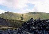
The fell has twin summits, Great and Little Sca Fell, with Little Sca Fell, which reaches an altitude of 635 metres, lying 400 metres north of the main summit across a low col, it has a more substantial cairn
and a strange depression which has been augmented by a low wall to make a wind shelter. The summit of Great Sca Fell itself is a broad flat plateau on which the highest point could be located almost at any point within a 15 metre radius, however it has a small cairn to mark the recognised top. Four ridges radiate from the summit to the adjoining fells of Knott (south), Brae Fell
(north), Meal Fell (west) and Longlands Fell (north west) making Great Sca Fell strategically important when walking these lonely hills. The River Ellen
has its source on the western slopes of Great Sca Fell, flowing westerly to the Solway Firth
. Drainage from the east of the fell flows eventually into the River Caldew
and then the Eden
to again reach the sea at the Solway.
. The view of Lakeland to the south is severely curtailed by the Skiddaw
massif but there is distant view of the Bowfell
group of fells almost 30 kilometres away through a gap in the hills.
Fell
“Fell” is a word used to refer to mountains, or certain types of mountainous landscape, in Scandinavia, the Isle of Man, and parts of northern England.- Etymology :...
in the English Lake District
Lake District
The Lake District, also commonly known as The Lakes or Lakeland, is a mountainous region in North West England. A popular holiday destination, it is famous not only for its lakes and its mountains but also for its associations with the early 19th century poetry and writings of William Wordsworth...
, it stands seven kilometres southwest of the village of Caldbeck
Caldbeck
Caldbeck is a village and civil parish in the Borough of Allerdale, Cumbria, England. Historically within Cumberland, the village had 714 inhabitants according to the census of 2001. It lies on the northern edge of the Lake District. The nearest town is Wigton, 6 miles north east of the village...
and is the highest of the four Uldale Fells (the other three being Longlands Fell
Longlands Fell
Longlands Fell is a small fell in the northern part of the English Lake District. It is situated in the high ground known as the Uldale Fells, 5.5 kilometres south west of the village of Caldbeck...
, Meal Fell
Meal Fell
Meal Fell is a small fell in the northern region of the English Lake District, it is situated seven kilometres south west of the village of Caldbeck and is one of the four main Uldale Fells ....
and Great Cockup
Great Cockup
Great Cockup is a fell in the northern region of the English Lake District, one of the four Uldale Fells .- Description :...
).
Topography
The Uldale fells are a smooth and grassy sheep pasture which rise in three ridges from the low land to the north and culminate at the summit of Great Sca Fell at a height of 651 m (2,136 ft). Although the hill is a “Wainwright” fell and comfortably crests the 2000 foot mark, it does not meet the criteria for any of the other major hill listsHill lists in the British Isles
The mountains and hills of Great Britain, and to a lesser extent Ireland, are the subject of a considerable number of lists that categorise them by height, topographic prominence, or other criteria. They are commonly used as a basis for peak bagging, whereby hillwalkers attempt to reach all the...
, with a prominence
Topographic prominence
In topography, prominence, also known as autonomous height, relative height, shoulder drop , or prime factor , categorizes the height of the mountain's or hill's summit by the elevation between it and the lowest contour line encircling it and no higher summit...
of 13 metres to the higher fell of Knott
Knott
Knott is a mountain in the northern part of the English Lake District. It is the highest point of the Back o'Skiddaw region, an area of wild and unfrequented moorland to the north of Skiddaw and Blencathra. Other tops in this region include High Pike, Carrock Fell and Great Calva. The fell's slopes...
it narrowly fails to qualify as a Nuttall.
The fell has twin summits, Great and Little Sca Fell, with Little Sca Fell, which reaches an altitude of 635 metres, lying 400 metres north of the main summit across a low col, it has a more substantial cairn
Cairn
Cairn is a term used mainly in the English-speaking world for a man-made pile of stones. It comes from the or . Cairns are found all over the world in uplands, on moorland, on mountaintops, near waterways and on sea cliffs, and also in barren desert and tundra areas...
and a strange depression which has been augmented by a low wall to make a wind shelter. The summit of Great Sca Fell itself is a broad flat plateau on which the highest point could be located almost at any point within a 15 metre radius, however it has a small cairn to mark the recognised top. Four ridges radiate from the summit to the adjoining fells of Knott (south), Brae Fell
Brae Fell
Brae Fell is a fell in the English Lake District, situated 12 kilometres north of Keswick it reaches a height of 586 m and is regarded as part of the Caldbeck Fells along with High Pike and Carrock Fell even though it has ridge links to the Uldale Fells. The fell's name has Scottish overtones...
(north), Meal Fell (west) and Longlands Fell (north west) making Great Sca Fell strategically important when walking these lonely hills. The River Ellen
River Ellen
The River Ellen is a river in the English county of Cumbria .The river rises on the Uldale Fells and runs in a generally western direction, passing Uldale, Ireby, Boltongate, Baggrow and Blennerhasset parish boundary and Aspatria.From there, it continues southwest past Oughterside, Gilcrux,...
has its source on the western slopes of Great Sca Fell, flowing westerly to the Solway Firth
Solway Firth
The Solway Firth is a firth that forms part of the border between England and Scotland, between Cumbria and Dumfries and Galloway. It stretches from St Bees Head, just south of Whitehaven in Cumbria, to the Mull of Galloway, on the western end of Dumfries and Galloway. The Isle of Man is also very...
. Drainage from the east of the fell flows eventually into the River Caldew
River Caldew
The River Caldew is a river running through Cumbria in England. Historically, the county watered by the Caldew was Cumberland.The Caldew's source is high up on Skiddaw, between the summit and Sale How, in the Lake District, from where it runs east through a valley between Bowscale Fell and Carrock...
and then the Eden
River Eden, Cumbria
The River Eden is a river that flows through Cumbria, England on its way to the Solway Firth.-Course of river:The Eden rises in Black Fell Moss, Mallerstang, on the high ground between High Seat, Yorkshire Dales and Hugh Seat. Here it forms the boundary between the counties of Cumbria and North...
to again reach the sea at the Solway.
Ascents
Ascents of Great Sca Fell are usually started from the minor road which skirts the Uldale fells to the north west with the hamlets of Orthwaite and Longlands as likely starting points, either approaching up the valleys or climbing the other fells on the way and then approaching by the connecting ridges.View
The highlight of the view from the top of the fell is northwards to the Solway plain and beyond to the Scottish BordersScottish Borders
The Scottish Borders is one of 32 local government council areas of Scotland. It is bordered by Dumfries and Galloway in the west, South Lanarkshire and West Lothian in the north west, City of Edinburgh, East Lothian, Midlothian to the north; and the non-metropolitan counties of Northumberland...
. The view of Lakeland to the south is severely curtailed by the Skiddaw
Skiddaw
Skiddaw is a mountain in the Lake District National Park in England. With a summit at 931 m above sea level it is the fourth highest mountain in England. It lies just north of the town of Keswick, Cumbria, and dominates the skyline in this part of the northern lakes...
massif but there is distant view of the Bowfell
Bowfell
Bowfell is a pyramid-shaped mountain lying at the heart of the English Lake District, in the Southern Fells area. It is the sixth highest mountain in the lakes and one of the most popular of the Lake District fells...
group of fells almost 30 kilometres away through a gap in the hills.