
Bannerdale Crags
Encyclopedia
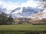
Bannerdale Crags is a fell
in the English
Lake District
. It stands between Blencathra
and Bowscale Fell
in the Northern Fells
.
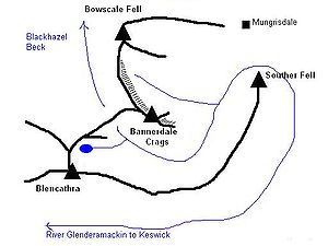
A broad convex slope descends northward from Blencathra's Atkinson Pike top, gradually resolving into two ridges. The western arm continues to Mungrisdale Common
while the north eastern limb, flecked with outcropping rock, falls to a steep sided col
at 2020 ft (615.7 m). From the depression Blackhazel Beck descends north west to join the River Caldew
while the source of the Glenderamackin lies on the opposite slope. Across the col smooth slopes rise once more up the south western flank of the Bannerdale Crags ridge. There is little clue here to the wall of crags on the other side.
The north eastern side of the ridge looks down upon the valley of Bannerdale Beck, a tributary of the Glenderamackin. The crags on this side are almost continuous for a mile in length, the highest sections falling 600 ft (182.9 m) to the valley. The major breach is a spur protruding from the face almost below the summit, providing a fine route of ascent.(see below)
To the north the summit ridge continues across a broad grassy saddle to Bowscale Fell, the crags continuing a little way into the territory of the neighbouring fell. By contrast to the south east the fell ends in White Horse Bent, the abrupt ridge-end descent to the Glenderamackin. This river has one of the most convoluted passages in the district, passing around the south and east of Bannerdale Crags, before turning back on itself to surround Souther Fell
on almost all sides and finally head west for Keswick and the River Derwent.
of flat stones. Nearer the face is another cairn, referred to on older large scale maps as a currick. A currick is a stone shelter built by shepherds. The view is surpringly extensive, the Coniston Fells being in sight to the south, 20 miles (32.2 km) away. The Eastern
and Far Eastern Fells
are also in view, but the highlight is probably Sharp Edge and the eastern prospect of Blencathra.
and siltstone
with greywacke
sandstone and is of Ordovician
age.
Bannerdale lead
mine was operated at the base of the crag itself, primarily in the latter half of the nineteenth century. This raised galena
and blende
from an east- west vein system with two major levels being over 100 ft long. Further workings below the summit were known as the graphite
level. It is not known how much was found, but the level has only been driven a few feet.
Saddleback Old Mine lies to the south of the fell, near to the col connecting it with Blencathra. This was also driven for lead, but the vein proved to consist mainly of limonite
. An attempt was made to market this as a pigment, but commercial success was elusive and there are no records of operation after 1894.
Less direct is the climb from Scales, first crossing Mousthwaite Combe to reach the Glenderamackin to the south of the fell. From here a straightforward assault on White Horse Bent is one alternative, or the miners track can be followed to Saddleback Old Mine and the source of the river.
Fell
“Fell” is a word used to refer to mountains, or certain types of mountainous landscape, in Scandinavia, the Isle of Man, and parts of northern England.- Etymology :...
in the English
England
England is a country that is part of the United Kingdom. It shares land borders with Scotland to the north and Wales to the west; the Irish Sea is to the north west, the Celtic Sea to the south west, with the North Sea to the east and the English Channel to the south separating it from continental...
Lake District
Lake District
The Lake District, also commonly known as The Lakes or Lakeland, is a mountainous region in North West England. A popular holiday destination, it is famous not only for its lakes and its mountains but also for its associations with the early 19th century poetry and writings of William Wordsworth...
. It stands between Blencathra
Blencathra
Blencathra, also known as Saddleback, is one of the most northerly mountains in the English Lake District. It has six separate fell tops, of which the highest is the Hallsfell Top.-Name:...
and Bowscale Fell
Bowscale Fell
Bowscale Fell is a hill in the English Lake District. It rises above the village of Mungrisdale in the Northern Fells. Bowscale Fell stands at the extreme north east the Blencathra group, connected to this higher fell by the intervening Bannerdale Crags...
in the Northern Fells
Northern Fells
The Northern Fells are a group of hills in the English Lake District. Including Skiddaw, they occupy a wide area to the north of Keswick. Smooth sweeping slopes predominate with a minimum of tarns or crags...
.
Topography
Bannerdale Crags is a ridge running north west to south east. The name was originally applied purely to the steep north eastern flank, but is now generally given to the fell as a whole.A broad convex slope descends northward from Blencathra's Atkinson Pike top, gradually resolving into two ridges. The western arm continues to Mungrisdale Common
Mungrisdale Common
Mungrisdale Common, pronounced mun-grize-dl, with emphasis on grize, is a fell in the English Lake District. Although Alfred Wainwright listed it as one of the 214 featured hills in his influential Pictorial Guide to the Lakeland Fells it was his least favourite. He commented that it "has no more...
while the north eastern limb, flecked with outcropping rock, falls to a steep sided col
Mountain pass
A mountain pass is a route through a mountain range or over a ridge. If following the lowest possible route, a pass is locally the highest point on that route...
at 2020 ft (615.7 m). From the depression Blackhazel Beck descends north west to join the River Caldew
River Caldew
The River Caldew is a river running through Cumbria in England. Historically, the county watered by the Caldew was Cumberland.The Caldew's source is high up on Skiddaw, between the summit and Sale How, in the Lake District, from where it runs east through a valley between Bowscale Fell and Carrock...
while the source of the Glenderamackin lies on the opposite slope. Across the col smooth slopes rise once more up the south western flank of the Bannerdale Crags ridge. There is little clue here to the wall of crags on the other side.
The north eastern side of the ridge looks down upon the valley of Bannerdale Beck, a tributary of the Glenderamackin. The crags on this side are almost continuous for a mile in length, the highest sections falling 600 ft (182.9 m) to the valley. The major breach is a spur protruding from the face almost below the summit, providing a fine route of ascent.(see below)
To the north the summit ridge continues across a broad grassy saddle to Bowscale Fell, the crags continuing a little way into the territory of the neighbouring fell. By contrast to the south east the fell ends in White Horse Bent, the abrupt ridge-end descent to the Glenderamackin. This river has one of the most convoluted passages in the district, passing around the south and east of Bannerdale Crags, before turning back on itself to surround Souther Fell
Souther Fell
Souther Fell is a fell in the English Lake District. It stands to the south of Mungrisdale village in the Northern Fells. It is most famous for the appearance of a "spectral army", said to have been seen marching along its crest on Midsummer's Day, 1745...
on almost all sides and finally head west for Keswick and the River Derwent.
Summit and view
The summit of the fell is smooth and grassy, the highest point being set back from the crags and marked by a small cairnCairn
Cairn is a term used mainly in the English-speaking world for a man-made pile of stones. It comes from the or . Cairns are found all over the world in uplands, on moorland, on mountaintops, near waterways and on sea cliffs, and also in barren desert and tundra areas...
of flat stones. Nearer the face is another cairn, referred to on older large scale maps as a currick. A currick is a stone shelter built by shepherds. The view is surpringly extensive, the Coniston Fells being in sight to the south, 20 miles (32.2 km) away. The Eastern
Eastern Fells
The Eastern Fells are a group of hills in the English Lake District. Centred on Helvellyn they primarily comprise a north south ridge running between Ullswater and Lakeland's Central Valley.-Partition of the Lakeland Fells:...
and Far Eastern Fells
Far Eastern Fells
The Far Eastern Fells are a group of hills in the English Lake District. Reaching their highest point at High Street they occupy a broad area to the east of Ullswater and Kirkstone Pass. Much quieter than the central areas of Lakeland they offer in general easier but less exciting walking as the...
are also in view, but the highlight is probably Sharp Edge and the eastern prospect of Blencathra.
Geology and Mining
In common with much of the Northern Fells the Kirk Stile Formation of the Skiddaw Group predominates. This is composed of laminated mudstoneMudstone
Mudstone is a fine grained sedimentary rock whose original constituents were clays or muds. Grain size is up to 0.0625 mm with individual grains too small to be distinguished without a microscope. With increased pressure over time the platey clay minerals may become aligned, with the...
and siltstone
Siltstone
Siltstone is a sedimentary rock which has a grain size in the silt range, finer than sandstone and coarser than claystones.- Description :As its name implies, it is primarily composed of silt sized particles, defined as grains 1/16 - 1/256 mm or 4 to 8 on the Krumbein phi scale...
with greywacke
Greywacke
Greywacke or Graywacke is a variety of sandstone generally characterized by its hardness, dark color, and poorly sorted angular grains of quartz, feldspar, and small rock fragments or lithic fragments set in a compact, clay-fine matrix. It is a texturally immature sedimentary rock generally found...
sandstone and is of Ordovician
Ordovician
The Ordovician is a geologic period and system, the second of six of the Paleozoic Era, and covers the time between 488.3±1.7 to 443.7±1.5 million years ago . It follows the Cambrian Period and is followed by the Silurian Period...
age.
Bannerdale lead
Lead
Lead is a main-group element in the carbon group with the symbol Pb and atomic number 82. Lead is a soft, malleable poor metal. It is also counted as one of the heavy metals. Metallic lead has a bluish-white color after being freshly cut, but it soon tarnishes to a dull grayish color when exposed...
mine was operated at the base of the crag itself, primarily in the latter half of the nineteenth century. This raised galena
Galena
Galena is the natural mineral form of lead sulfide. It is the most important lead ore mineral.Galena is one of the most abundant and widely distributed sulfide minerals. It crystallizes in the cubic crystal system often showing octahedral forms...
and blende
Blende
Blende may refer to:* Sphalerite , the most common usage* Hornblende* Pitchblende* an alternative name for Rana Niejta...
from an east- west vein system with two major levels being over 100 ft long. Further workings below the summit were known as the graphite
Graphite
The mineral graphite is one of the allotropes of carbon. It was named by Abraham Gottlob Werner in 1789 from the Ancient Greek γράφω , "to draw/write", for its use in pencils, where it is commonly called lead . Unlike diamond , graphite is an electrical conductor, a semimetal...
level. It is not known how much was found, but the level has only been driven a few feet.
Saddleback Old Mine lies to the south of the fell, near to the col connecting it with Blencathra. This was also driven for lead, but the vein proved to consist mainly of limonite
Limonite
Limonite is an ore consisting in a mixture of hydrated iron oxide-hydroxide of varying composition. The generic formula is frequently written as FeO·nH2O, although this is not entirely accurate as limonite often contains a varying amount of oxide compared to hydroxide.Together with hematite, it has...
. An attempt was made to market this as a pigment, but commercial success was elusive and there are no records of operation after 1894.
Ascents
Starting from Mungrisdale village to the east the Glenderamackin can be followed as far as its confluence with Bannerdale Beck. From here the east spur climbs almost direct to the summit, the rock scenery improving throughout and ending with a gentle scramble. An alternative from Mungrisdale is the wide and easy track leading up to the ridge between Bannerdale Crags and Bowscale Fell.Less direct is the climb from Scales, first crossing Mousthwaite Combe to reach the Glenderamackin to the south of the fell. From here a straightforward assault on White Horse Bent is one alternative, or the miners track can be followed to Saddleback Old Mine and the source of the river.