
North American blizzard of 2006
Encyclopedia
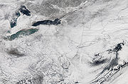
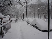
The Blizzard of 2006 was a nor'easter
that began on the evening of February 11, 2006. It dumped heavy snow
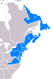
across the Northeast United States from Virginia
to Maine
through the early evening of February 12 and ended in Atlantic Canada
on February 13. The major northeast cities
from Baltimore
to Boston
received at least a foot of snow, with an all-time largest amount of 26.9 inches (68.3 cm) in New York City
, the most since at least 1869, the start of record keeping.
 Since the heaviest snow was confined to a fairly small, but very heavily populated area, the storm was only ranked as a low-end Category 3 (Major) on the new Northeast Snowfall Impact Scale
, which takes into account the area and population affected, as well as snowfall accumulations. This indirectly also reflects that fact that casualties were extremely low and cleanup was fairly quick, even in the New York City
area where the record snow amounts occurred. The main reasons for this are: A) The storm fell on a Sunday when many people can more easily stay home, B) the relatively small geographic area of extremely large snowfall, and C) Because the temperature was well below freezing throughout most of the storm, the snow was mostly dry and light in composition, as opposed to the wet and heavy snows that make some otherwise lesser storms much harder to clean up from and are more common at least in the coastal Northeast. Plus, temperatures in the days after the storm were unseasonably warm in some spots (reaching the mid-50s °F in hard-hit New York City
, and the mid 60s in DC) which helped melt the snow much more quickly than usual.
The storm system began developing on February 11 as a relatively minor system, bringing some snow along the southern Appalachian range. The low pressure center moved off-shore early February 12 before it began its exponential intensification. By early morning, snow began falling at a massive rate, taking several forecasters by surprise who had expected about a foot of snow, at most, along the eastern fringes of the Atlantic seaboard. During the height of the storm on Sunday morning the 12th, thunder and lightning occurred as the snow fell. The presence of this thundersnow
shows how energetic this storm became.
The reason for the extreme intensification was the result of a fairly mild winter that kept water temperatures in the Atlantic a few degrees warmer than they should have been for February. The storm system's intensity led to snowfall accumulations upwards of 32 inches (81.3 cm) in some localities.
In addition to the heavy snow, coastal flooding from storm surge
was reported, particularly in Massachusetts
. Storm surges have been recorded as high as 3 feet (1 m) in parts of New England.
The low pressure area
began forming in the Southern
states a few days prior to the Blizzard striking, eventually merging with a northern stream system. A trough
on the East Coast
brought the system up the coast, and cold to the north eventually slowed the system to a crawl. As the system completed bombing, or rapid decrease in central pressure (a common measure of the strength of a storm), mesoscale banding features (areas of significant snowfall associated with small scale physical phenomena) impinged on the entire I-95
Corridor.
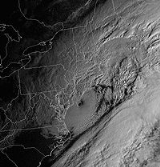
The low pressure center was so deep that somewhat of an eye actually formed. Rarely do eyes form on storms other than hurricanes, and it is especially rare in extratropical cyclone
s. NASA took a satellite picture of the eye of the storm; the eye was located south and east of southern New Jersey in this picture.
 Three casualties occurred as a result of the snow: in Virginia, a man died due to his truck sliding off a highway; in Baltimore, a person died in a house fire as a result of snow delaying rescue workers from getting to the fire. A third fatality occurred in a weather-related accident in Nova Scotia
.
was one of the hardest hit areas, the state was well-prepared for the storm and managed to avoid major problems. Hartford received a total of 21.9 inches (55 cm) of snow — the second largest snowfall since 1906. A total of 18 inches (46 cm) fell in the small Sandy Hook village. West Hartford totaled 27 inches (69 cm) and Fairfield saw 27.8 inches (70.6 cm) of snow. Despite the large amounts of snow, there were only isolated individual power outages. At the storm's onset, governor M. Jodi Rell
ordered all tractor-trailer trucks off the state's highways to facilitate the efforts of highway crews with snow removal. Motorists whose vehicles were not equipped with 4-wheel drive were required to use snow chains
to travel on state roadways during the storm. Connecticut mobilized 2,500 state-owned and privately contracted snowplow
s to keep state highways open during the storm. The state's 169 cities and towns employed hundreds of additional plows to keep local roads passable. Bradley International Airport
was closed for several hours, and the storm disrupted service on Metro North
.
and Wilmington
felt the brunt of this storm, with 14-15 inches (35–38 cm) of snow. Kent
and Sussex
counties to the south mixed with rain for a while, and saw significantly less snow accumulations, mostly in the 6 inch (15 cm) range.
missed the worst of the storm. The city received about 10 inches (24 cm) of snow, far less than in the suburb
s. Approximately 3,000 people lost electricity
in the District of Columbia. However, Ronald Reagan Washington National Airport
(just across the Potomac River
) was closed.
occurred. Snowfall amounts of up to 21 inches (53 cm) were reported in Columbia
, 13.1 inches (33.3 cm) in Baltimore, 17 inches (43 cm) in Catonsville
, and a foot (30.5 cm) in Potomac
. This was the area's heaviest snow since the North American blizzard of 2003
. Lesser amounts occurred in western and southern parts of the state.
Maryland was hardest hit by power outages. In the Baltimore
area, more than 62,000 people lost electricity, plus another 16,000 in Montgomery County
and 37,000 in Prince George's County
.
at times, but winds of up to 60 mph (95 km/h) whipped up the ocean with storm surges of 2 to 3 feet (60 to 90 cm) and led to some coastal flooding, plus offshore waves of up to 25 feet (8 m). Logan International Airport
in Boston and Barnstable municipal airport in Hyannis
on Cape Cod
saw over 90% of their flights cancelled at the peak of the storm.
There were no power outages, despite the conditions. There was one death; a tree fell onto a pickup truck in Billerica
, killing the driver. Strong winds across the state caused $1.9 million in damage (2006 USD).
was strong enough to stop the New Jersey Transit
bus
service between 7:30 a.m. and 4:00 p.m., although train
s continued to run (with some delays). Many roads remained closed. Businesses were closed for most of the day. 16,000 people were without power in the state. Central and northeastern New Jersey saw the brunt of the storm due to heavy banding through the night into the morning: 21" (53.3 cm) of snow fell at Newark Airport
and 27" fell in Rahway.
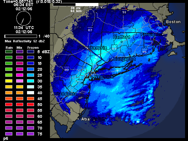
 The Greater New York City
area received the brunt of the February Blizzard of 2006. All three of the airport
s in the New York City
area (LaGuardia Airport
, John F. Kennedy International Airport
and Newark Liberty International Airport
) were closed during the record blizzard, for the first time since the September 11, 2001 attacks
. Like the Blizzard of 1996, this winter storm does not meet the criteria to be called a blizzard, however. The winds were not strong enough, and visibility was not poor enough. Thundersnow
, which is a rare occurrence in New York, occurred for about a 4 hour period in parts of Bronx, Manhattan
, Brooklyn
, Queens
, Rockland
and Westchester
during the height of the storm early Sunday morning.
Central Park
received 26.9 inches (68.3 cm) of snow, the largest amount for a single storm since records began, breaking the record of 26.4 inches (67.1 cm) that fell on December 26, 1947. By comparison, the blizzards of 1996 and 2003 dropped 20.2 and 19.8 inches (51.3 and 50.3 cm) in Central Park respectively. The smallest amounts of snowfall were recorded in portions of Nassau County, including the towns of Oceanside, Lynbrook, Rockville Centre and Island Park.
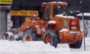
The snow removal
cost in New York City alone is estimated at about $27 million. It took nearly two days for utility crews to fully restore service to as many as 300,000 customers.
 The storm did not reach very far north of the city; the Albany
area only received 1-2 inches (2.5–5 cm) of snow. As a result, the 2005-06 winter season ended up being the first time ever since records began in the late 19th century that New York City
received more snow than Albany in a given winter (the inland, upstate city averages about twice as much snowfall per winter as its big neighbor to the south).
The strong winds downed trees and powerlines, resulting in $3 million in damage (2006 USD). The Long Island Railroad reported extensive delays and as many as eight trains disabled up to several hours after the blizzard. The Monday morning commute was no better, as two of the railroad's lines were shut down completely and delays caused headaches for ambitious commuters. By Tuesday, two days after the storm, service was back to normal.
Despite the record snowfall, the New York City schools were open on February 13, owing to planning and work by the city and its snowplow team.
, but 35 miles (56 km) to the west in West Caln Township, there were 21 inches (53 cm). Philadelphia International Airport remained open throughout the storm, although about 50% of flights were cancelled. There were also power outages in the Philadelphia area, with about 10,000 customers losing power. But in contrast, in Western Pennsylvania most got 1" (2.5 cm) or less of snow. Philadelphia public and parchocial schools were closed for the day.
, declared a statewide state of emergency
due to the blizzard conditions. The Providence Journal reported that state accumulations were generally between 9 and 19 inches (23 to 49 cm). Generally, Providence County received the heaviest accumulations in the state (see the chart below). On February 12, the bulk of the snow ended around 5:00 p.m. Eastern Standard Time, with flurries lasting through the early evening. No significant power outages or injuries were reported.
lost power in the storm, primarily in the suburban areas adjacent to Washington, D.C. Many locations in the extreme northeastern portion of the state recorded 10-15" (25–38 cm) of snow, with Falls Church and Fairfax coming in at 13.5" (34.3 cm) and 14.0" (35.6 cm) respectively. Fairfax County and eastern Loudoun County were generally the start of the 12+" (30+ cm) accumulations, which spread north towards Massachusetts.
, the winds increased substantially. The worst of the storm was felt along the Atlantic coast, particularly in a swath around the Bay of Fundy
, the Northumberland Strait
and the south coast of Newfoundland. Hurricane-force wind gusts were reported in several communities, peaking at 156 km/h (97 mph) in Grand Etang, Nova Scotia
(equal to a Category 2
hurricane) and 133 km/h (83 mph) in Cape Race
on the east coast of Newfoundland. Some damage was reported as a result of the strong winds, particularly downed power lines but also some roof damage to buildings.
 Only accumulations of 8 inches (20 cm) or greater are listed. Not all observations are listed due to space limitations; only major communities and notable reports are listed.
Sources: National Weather Service
local offices - Sterling, VA, Mount Holly, NJ, Upton, NY,
Taunton, MA, Caribou, ME, Gray, ME
Nor'easter
A nor'easter is a type of macro-scale storm along the East Coast of the United States and Atlantic Canada, so named because the storm travels to the northeast from the south and the winds come from the northeast, especially in the coastal areas of the Northeastern United States and Atlantic Canada...
that began on the evening of February 11, 2006. It dumped heavy snow
Snow
Snow is a form of precipitation within the Earth's atmosphere in the form of crystalline water ice, consisting of a multitude of snowflakes that fall from clouds. Since snow is composed of small ice particles, it is a granular material. It has an open and therefore soft structure, unless packed by...
across the Northeast United States from Virginia
Virginia
The Commonwealth of Virginia , is a U.S. state on the Atlantic Coast of the Southern United States. Virginia is nicknamed the "Old Dominion" and sometimes the "Mother of Presidents" after the eight U.S. presidents born there...
to Maine
Maine
Maine is a state in the New England region of the northeastern United States, bordered by the Atlantic Ocean to the east and south, New Hampshire to the west, and the Canadian provinces of Quebec to the northwest and New Brunswick to the northeast. Maine is both the northernmost and easternmost...
through the early evening of February 12 and ended in Atlantic Canada
Atlantic Canada
Atlantic Canada is the region of Canada comprising the four provinces located on the Atlantic coast, excluding Quebec: the three Maritime provinces – New Brunswick, Prince Edward Island, and Nova Scotia – and Newfoundland and Labrador...
on February 13. The major northeast cities
City
A city is a relatively large and permanent settlement. Although there is no agreement on how a city is distinguished from a town within general English language meanings, many cities have a particular administrative, legal, or historical status based on local law.For example, in the U.S...
from Baltimore
Baltimore
Baltimore is the largest independent city in the United States and the largest city and cultural center of the US state of Maryland. The city is located in central Maryland along the tidal portion of the Patapsco River, an arm of the Chesapeake Bay. Baltimore is sometimes referred to as Baltimore...
to Boston
Boston
Boston is the capital of and largest city in Massachusetts, and is one of the oldest cities in the United States. The largest city in New England, Boston is regarded as the unofficial "Capital of New England" for its economic and cultural impact on the entire New England region. The city proper had...
received at least a foot of snow, with an all-time largest amount of 26.9 inches (68.3 cm) in New York City
New York City
New York is the most populous city in the United States and the center of the New York Metropolitan Area, one of the most populous metropolitan areas in the world. New York exerts a significant impact upon global commerce, finance, media, art, fashion, research, technology, education, and...
, the most since at least 1869, the start of record keeping.
Meteorological information
Northeast Snowfall Impact Scale
The Northeast Snowfall Impact Scale was created to measure snowstorms in the U.S. Northeast in much the same way the Saffir-Simpson Hurricane Scale records hurricane intensity and the Enhanced Fujita Scale with tornadoes.-The Scale:...
, which takes into account the area and population affected, as well as snowfall accumulations. This indirectly also reflects that fact that casualties were extremely low and cleanup was fairly quick, even in the New York City
New York City
New York is the most populous city in the United States and the center of the New York Metropolitan Area, one of the most populous metropolitan areas in the world. New York exerts a significant impact upon global commerce, finance, media, art, fashion, research, technology, education, and...
area where the record snow amounts occurred. The main reasons for this are: A) The storm fell on a Sunday when many people can more easily stay home, B) the relatively small geographic area of extremely large snowfall, and C) Because the temperature was well below freezing throughout most of the storm, the snow was mostly dry and light in composition, as opposed to the wet and heavy snows that make some otherwise lesser storms much harder to clean up from and are more common at least in the coastal Northeast. Plus, temperatures in the days after the storm were unseasonably warm in some spots (reaching the mid-50s °F in hard-hit New York City
New York City
New York is the most populous city in the United States and the center of the New York Metropolitan Area, one of the most populous metropolitan areas in the world. New York exerts a significant impact upon global commerce, finance, media, art, fashion, research, technology, education, and...
, and the mid 60s in DC) which helped melt the snow much more quickly than usual.
The storm system began developing on February 11 as a relatively minor system, bringing some snow along the southern Appalachian range. The low pressure center moved off-shore early February 12 before it began its exponential intensification. By early morning, snow began falling at a massive rate, taking several forecasters by surprise who had expected about a foot of snow, at most, along the eastern fringes of the Atlantic seaboard. During the height of the storm on Sunday morning the 12th, thunder and lightning occurred as the snow fell. The presence of this thundersnow
Thundersnow
Thundersnow, also known as a winter thunderstorm or a thunder snowstorm, is a relatively rare kind of thunderstorm with snow falling as the primary precipitation instead of rain. It typically falls in regions of strong upward motion within the cold sector of an extratropical cyclone...
shows how energetic this storm became.
The reason for the extreme intensification was the result of a fairly mild winter that kept water temperatures in the Atlantic a few degrees warmer than they should have been for February. The storm system's intensity led to snowfall accumulations upwards of 32 inches (81.3 cm) in some localities.
In addition to the heavy snow, coastal flooding from storm surge
Storm surge
A storm surge is an offshore rise of water associated with a low pressure weather system, typically tropical cyclones and strong extratropical cyclones. Storm surges are caused primarily by high winds pushing on the ocean's surface. The wind causes the water to pile up higher than the ordinary sea...
was reported, particularly in Massachusetts
Massachusetts
The Commonwealth of Massachusetts is a state in the New England region of the northeastern United States of America. It is bordered by Rhode Island and Connecticut to the south, New York to the west, and Vermont and New Hampshire to the north; at its east lies the Atlantic Ocean. As of the 2010...
. Storm surges have been recorded as high as 3 feet (1 m) in parts of New England.
The low pressure area
Low pressure area
A low-pressure area, or "low", is a region where the atmospheric pressure at sea level is below that of surrounding locations. Low-pressure systems form under areas of wind divergence which occur in upper levels of the troposphere. The formation process of a low-pressure area is known as...
began forming in the Southern
Southern United States
The Southern United States—commonly referred to as the American South, Dixie, or simply the South—constitutes a large distinctive area in the southeastern and south-central United States...
states a few days prior to the Blizzard striking, eventually merging with a northern stream system. A trough
Trough (meteorology)
A trough is an elongated region of relatively low atmospheric pressure, often associated with fronts.Unlike fronts, there is not a universal symbol for a trough on a weather chart. The weather charts in some countries or regions mark troughs by a line. In the United States, a trough may be marked...
on the East Coast
East Coast of the United States
The East Coast of the United States, also known as the Eastern Seaboard, refers to the easternmost coastal states in the United States, which touch the Atlantic Ocean and stretch up to Canada. The term includes the U.S...
brought the system up the coast, and cold to the north eventually slowed the system to a crawl. As the system completed bombing, or rapid decrease in central pressure (a common measure of the strength of a storm), mesoscale banding features (areas of significant snowfall associated with small scale physical phenomena) impinged on the entire I-95
Interstate 95
Interstate 95 is the main highway on the East Coast of the United States, running parallel to the Atlantic Ocean from Maine to Florida and serving some of the most populated urban areas in the country, including Boston, Providence, New Haven, New York City, Newark, Philadelphia, Baltimore,...
Corridor.
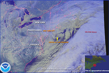
The low pressure center was so deep that somewhat of an eye actually formed. Rarely do eyes form on storms other than hurricanes, and it is especially rare in extratropical cyclone
Extratropical cyclone
Extratropical cyclones, sometimes called mid-latitude cyclones or wave cyclones, are a group of cyclones defined as synoptic scale low pressure weather systems that occur in the middle latitudes of the Earth having neither tropical nor polar characteristics, and are connected with fronts and...
s. NASA took a satellite picture of the eye of the storm; the eye was located south and east of southern New Jersey in this picture.
Impact
Nova Scotia
Nova Scotia is one of Canada's three Maritime provinces and is the most populous province in Atlantic Canada. The name of the province is Latin for "New Scotland," but "Nova Scotia" is the recognized, English-language name of the province. The provincial capital is Halifax. Nova Scotia is the...
.
Connecticut
While ConnecticutConnecticut
Connecticut is a state in the New England region of the northeastern United States. It is bordered by Rhode Island to the east, Massachusetts to the north, and the state of New York to the west and the south .Connecticut is named for the Connecticut River, the major U.S. river that approximately...
was one of the hardest hit areas, the state was well-prepared for the storm and managed to avoid major problems. Hartford received a total of 21.9 inches (55 cm) of snow — the second largest snowfall since 1906. A total of 18 inches (46 cm) fell in the small Sandy Hook village. West Hartford totaled 27 inches (69 cm) and Fairfield saw 27.8 inches (70.6 cm) of snow. Despite the large amounts of snow, there were only isolated individual power outages. At the storm's onset, governor M. Jodi Rell
M. Jodi Rell
Mary Jodi Rell is a Republican politician and was the 87th Governor of the U.S. state of Connecticut from 2004 until 2011. She was the Lieutenant Governor of Connecticut under Governor John G. Rowland, who resigned during a corruption investigation. Rell is Connecticut's second female Governor,...
ordered all tractor-trailer trucks off the state's highways to facilitate the efforts of highway crews with snow removal. Motorists whose vehicles were not equipped with 4-wheel drive were required to use snow chains
Snow chains
Snow chains, or tire chains, are devices fitted to the tires of vehicles to provide maximum traction when driving through snow and ice....
to travel on state roadways during the storm. Connecticut mobilized 2,500 state-owned and privately contracted snowplow
Snowplow
A snowplow is a device intended for mounting on a vehicle, used for removing snow and ice from outdoor surfaces, typically those serving transportation purposes...
s to keep state highways open during the storm. The state's 169 cities and towns employed hundreds of additional plows to keep local roads passable. Bradley International Airport
Bradley International Airport
Bradley International Airport is a joint civil-military public airport located in Windsor Locks on the border with East Granby and Suffield, in Hartford County, Connecticut, United States. It is owned by the State of Connecticut....
was closed for several hours, and the storm disrupted service on Metro North
Metro north
Metro North can refer to either of* Metro-North Railroad, a commuter railroad serving parts of New York and Connecticut in the United States* Dublin Metro#Metro North, a branch of the proposed Dublin Metro, in Dublin, Ireland...
.
Delaware
New Castle CountyNew Castle County, Delaware
New Castle County is the northernmost of the three counties of the U.S. state of Delaware. As of 2010 its population was 538,479, an increase of 7.6% over the previous decade. The county seat is Wilmington. The center of population of Delaware is located in New Castle County, in the town of...
and Wilmington
Wilmington, Delaware
Wilmington is the largest city in the state of Delaware, United States, and is located at the confluence of the Christina River and Brandywine Creek, near where the Christina flows into the Delaware River. It is the county seat of New Castle County and one of the major cities in the Delaware Valley...
felt the brunt of this storm, with 14-15 inches (35–38 cm) of snow. Kent
Kent County, Delaware
Kent County is a county located in the central part of the U.S. state of Delaware. It is coextensive with the Dover, Delaware, Metropolitan Statistical Area. As of 2010 the population was 162,310, a 28.1% increase over the previous decade. The county seat is Dover, the state capital...
and Sussex
Sussex County, Delaware
Sussex County is a county located in the southern part of the U.S. state of Delaware. As of 2010 the population was 197,145, an increase of 25.9% over the previous decade. The county seat is Georgetown. The Seaford Micropolitan Statistical Area includes all of Sussex County.Sussex County is...
counties to the south mixed with rain for a while, and saw significantly less snow accumulations, mostly in the 6 inch (15 cm) range.
District of Columbia
The city of Washington, D.C.Washington, D.C.
Washington, D.C., formally the District of Columbia and commonly referred to as Washington, "the District", or simply D.C., is the capital of the United States. On July 16, 1790, the United States Congress approved the creation of a permanent national capital as permitted by the U.S. Constitution....
missed the worst of the storm. The city received about 10 inches (24 cm) of snow, far less than in the suburb
Suburb
The word suburb mostly refers to a residential area, either existing as part of a city or as a separate residential community within commuting distance of a city . Some suburbs have a degree of administrative autonomy, and most have lower population density than inner city neighborhoods...
s. Approximately 3,000 people lost electricity
Electricity
Electricity is a general term encompassing a variety of phenomena resulting from the presence and flow of electric charge. These include many easily recognizable phenomena, such as lightning, static electricity, and the flow of electrical current in an electrical wire...
in the District of Columbia. However, Ronald Reagan Washington National Airport
Ronald Reagan Washington National Airport
Ronald Reagan Washington National Airport is a public airport located south of downtown Washington, D.C., in Arlington County, Virginia. It is the commercial airport nearest to Washington, D.C. For many decades, it was called Washington National Airport, but this airport was renamed in 1998 to...
(just across the Potomac River
Potomac River
The Potomac River flows into the Chesapeake Bay, located along the mid-Atlantic coast of the United States. The river is approximately long, with a drainage area of about 14,700 square miles...
) was closed.
Maryland
The heaviest snow in Maryland fell from the northern suburbs of Washington, D.C., to the Baltimore area. These areas overwhelmingly saw over a foot of snow. Snowfall rates of 2-3 inches (5–8 cm) per hour were common, and thundersnowThundersnow
Thundersnow, also known as a winter thunderstorm or a thunder snowstorm, is a relatively rare kind of thunderstorm with snow falling as the primary precipitation instead of rain. It typically falls in regions of strong upward motion within the cold sector of an extratropical cyclone...
occurred. Snowfall amounts of up to 21 inches (53 cm) were reported in Columbia
Columbia, Maryland
Columbia is a planned community that consists of ten self-contained villages, located in Howard County, Maryland, United States. It began with the idea that a city could enhance its residents' quality of life. Creator and developer James W. Rouse saw the new community in terms of human values, not...
, 13.1 inches (33.3 cm) in Baltimore, 17 inches (43 cm) in Catonsville
Catonsville, Maryland
According to the United States Census Bureau, the CDP has a total area of , all of it land.-Demographics:In 2010 Catonsville had a population of 41,567...
, and a foot (30.5 cm) in Potomac
Potomac, Maryland
Potomac is a census-designated place in Montgomery County, Maryland, United States, named for the nearby Potomac River. The population was 44,822 at the 2000 census. The Potomac area is known for its very affluent and highly-educated residents. In 2009 CNNMoney.com listed Potomac as the fourth...
. This was the area's heaviest snow since the North American blizzard of 2003
North American blizzard of 2003
The Blizzard of 2003, also known as the Presidents' Day Storm II or simply PDII, was a historical and record-breaking snowstorm on the East Coast of the United States and Canada, which lasted from February 14 to February 19, 2003. It spread heavy snow across the major cities of the Northeastern US,...
. Lesser amounts occurred in western and southern parts of the state.
Maryland was hardest hit by power outages. In the Baltimore
Baltimore
Baltimore is the largest independent city in the United States and the largest city and cultural center of the US state of Maryland. The city is located in central Maryland along the tidal portion of the Patapsco River, an arm of the Chesapeake Bay. Baltimore is sometimes referred to as Baltimore...
area, more than 62,000 people lost electricity, plus another 16,000 in Montgomery County
Montgomery County, Maryland
Montgomery County is a county in the U.S. state of Maryland, situated just to the north of Washington, D.C., and southwest of the city of Baltimore. It is one of the most affluent counties in the United States, and has the highest percentage of residents over 25 years of age who hold post-graduate...
and 37,000 in Prince George's County
Prince George's County, Maryland
Prince George's County is a county located in the U.S. state of Maryland, immediately north, east, and south of Washington, DC. As of 2010, it has a population of 863,420 and is the wealthiest African-American majority county in the nation....
.
Massachusetts
The most serious coastal problems were in Massachusetts. The heaviest snow was in the central part of the state, where snow amounts of up to 20 inches (50 cm) were reported. Coastal areas, particularly around Nantucket, saw lesser amounts (approximately 12") as it was mixed with sleetIce storm
An ice storm is a type of winter storm characterized by freezing rain, also known as a glaze event or in some parts of the United States as a silver thaw. The U.S. National Weather Service defines an ice storm as a storm which results in the accumulation of at least of ice on exposed surfaces...
at times, but winds of up to 60 mph (95 km/h) whipped up the ocean with storm surges of 2 to 3 feet (60 to 90 cm) and led to some coastal flooding, plus offshore waves of up to 25 feet (8 m). Logan International Airport
Logan International Airport
General Edward Lawrence Logan International Airport is located in the East Boston neighborhood of Boston, Massachusetts . It covers , has six runways, and employs an estimated 16,000 people. It is the 19th busiest airport in the United States.Boston serves as a focus city for JetBlue Airways...
in Boston and Barnstable municipal airport in Hyannis
Hyannis, Massachusetts
Hyannis is the largest of seven villages in Barnstable, Massachusetts. Also it is the commercial and transportation hub of Cape Cod and was designated an urban area as a result of the 1990 census. Because of this, many refer to Hyannis as the "Capital of the Cape"...
on Cape Cod
Cape Cod
Cape Cod, often referred to locally as simply the Cape, is a cape in the easternmost portion of the state of Massachusetts, in the Northeastern United States...
saw over 90% of their flights cancelled at the peak of the storm.
There were no power outages, despite the conditions. There was one death; a tree fell onto a pickup truck in Billerica
Billerica, Massachusetts
Billerica is a town in Middlesex County, Massachusetts, United States. The population was 40,243 at the 2010 census. It is the only town named Billerica in the United States and borrows its name from the town of Billericay in Essex, England.- History :...
, killing the driver. Strong winds across the state caused $1.9 million in damage (2006 USD).
New Jersey
The impact of the blizzard in northern New JerseyNew Jersey
New Jersey is a state in the Northeastern and Middle Atlantic regions of the United States. , its population was 8,791,894. It is bordered on the north and east by the state of New York, on the southeast and south by the Atlantic Ocean, on the west by Pennsylvania and on the southwest by Delaware...
was strong enough to stop the New Jersey Transit
New Jersey Transit
The New Jersey Transit Corporation is a statewide public transportation system serving the United States state of New Jersey, and New York, Orange, and Rockland counties in New York State...
bus
New Jersey Transit Bus Operations
New Jersey Transit Bus Operations is the bus division of New Jersey Transit, providing bus service throughout New Jersey along with service along one light rail line, with many routes going to New York City and Philadelphia.-History:...
service between 7:30 a.m. and 4:00 p.m., although train
Train
A train is a connected series of vehicles for rail transport that move along a track to transport cargo or passengers from one place to another place. The track usually consists of two rails, but might also be a monorail or maglev guideway.Propulsion for the train is provided by a separate...
s continued to run (with some delays). Many roads remained closed. Businesses were closed for most of the day. 16,000 people were without power in the state. Central and northeastern New Jersey saw the brunt of the storm due to heavy banding through the night into the morning: 21" (53.3 cm) of snow fell at Newark Airport
Newark Liberty International Airport
Newark Liberty International Airport , first named Newark Metropolitan Airport and later Newark International Airport, is an international airport within the city limits of both Newark and Elizabeth, New Jersey, United States...
and 27" fell in Rahway.
New York
New York metropolitan area
The New York metropolitan area, also known as Greater New York, or the Tri-State area, is the region that composes of New York City and the surrounding region...
area received the brunt of the February Blizzard of 2006. All three of the airport
Airport
An airport is a location where aircraft such as fixed-wing aircraft, helicopters, and blimps take off and land. Aircraft may be stored or maintained at an airport...
s in the New York City
New York City
New York is the most populous city in the United States and the center of the New York Metropolitan Area, one of the most populous metropolitan areas in the world. New York exerts a significant impact upon global commerce, finance, media, art, fashion, research, technology, education, and...
area (LaGuardia Airport
LaGuardia Airport
LaGuardia Airport is an airport located in the northern part of Queens County on Long Island in the City of New York. The airport is located on the waterfront of Flushing Bay and Bowery Bay, and borders the neighborhoods of Astoria, Jackson Heights and East Elmhurst. The airport was originally...
, John F. Kennedy International Airport
John F. Kennedy International Airport
John F. Kennedy International Airport is an international airport located in the borough of Queens in New York City, about southeast of Lower Manhattan. It is the busiest international air passenger gateway to the United States, handling more international traffic than any other airport in North...
and Newark Liberty International Airport
Newark Liberty International Airport
Newark Liberty International Airport , first named Newark Metropolitan Airport and later Newark International Airport, is an international airport within the city limits of both Newark and Elizabeth, New Jersey, United States...
) were closed during the record blizzard, for the first time since the September 11, 2001 attacks
September 11, 2001 attacks
The September 11 attacks The September 11 attacks The September 11 attacks (also referred to as September 11, September 11th or 9/119/11 is pronounced "nine eleven". The slash is not part of the pronunciation...
. Like the Blizzard of 1996, this winter storm does not meet the criteria to be called a blizzard, however. The winds were not strong enough, and visibility was not poor enough. Thundersnow
Thundersnow
Thundersnow, also known as a winter thunderstorm or a thunder snowstorm, is a relatively rare kind of thunderstorm with snow falling as the primary precipitation instead of rain. It typically falls in regions of strong upward motion within the cold sector of an extratropical cyclone...
, which is a rare occurrence in New York, occurred for about a 4 hour period in parts of Bronx, Manhattan
Manhattan
Manhattan is the oldest and the most densely populated of the five boroughs of New York City. Located primarily on the island of Manhattan at the mouth of the Hudson River, the boundaries of the borough are identical to those of New York County, an original county of the state of New York...
, Brooklyn
Brooklyn
Brooklyn is the most populous of New York City's five boroughs, with nearly 2.6 million residents, and the second-largest in area. Since 1896, Brooklyn has had the same boundaries as Kings County, which is now the most populous county in New York State and the second-most densely populated...
, Queens
Queens
Queens is the easternmost of the five boroughs of New York City. The largest borough in area and the second-largest in population, it is coextensive with Queens County, an administrative division of New York state, in the United States....
, Rockland
Rockland County, New York
Rockland County is a suburban county 15 miles to the northwest of Manhattan and part of the New York City Metropolitan Area, in the U.S. state of New York. It is the southernmost county in New York west of the Hudson River, and the smallest county in New York outside of New York City. The...
and Westchester
Westchester County, New York
Westchester County is a county located in the U.S. state of New York. Westchester covers an area of and has a population of 949,113 according to the 2010 Census, residing in 45 municipalities...
during the height of the storm early Sunday morning.
Central Park
Central Park
Central Park is a public park in the center of Manhattan in New York City, United States. The park initially opened in 1857, on of city-owned land. In 1858, Frederick Law Olmsted and Calvert Vaux won a design competition to improve and expand the park with a plan they entitled the Greensward Plan...
received 26.9 inches (68.3 cm) of snow, the largest amount for a single storm since records began, breaking the record of 26.4 inches (67.1 cm) that fell on December 26, 1947. By comparison, the blizzards of 1996 and 2003 dropped 20.2 and 19.8 inches (51.3 and 50.3 cm) in Central Park respectively. The smallest amounts of snowfall were recorded in portions of Nassau County, including the towns of Oceanside, Lynbrook, Rockville Centre and Island Park.
The snow removal
Snow removal
Snow removal is the job of removing snow after a snowfall to make travel easier and safer. This is done by both individual households and by governments and institutions.-De-icing and anti-icing:...
cost in New York City alone is estimated at about $27 million. It took nearly two days for utility crews to fully restore service to as many as 300,000 customers.
Albany, New York
Albany is the capital city of the U.S. state of New York, the seat of Albany County, and the central city of New York's Capital District. Roughly north of New York City, Albany sits on the west bank of the Hudson River, about south of its confluence with the Mohawk River...
area only received 1-2 inches (2.5–5 cm) of snow. As a result, the 2005-06 winter season ended up being the first time ever since records began in the late 19th century that New York City
New York City
New York is the most populous city in the United States and the center of the New York Metropolitan Area, one of the most populous metropolitan areas in the world. New York exerts a significant impact upon global commerce, finance, media, art, fashion, research, technology, education, and...
received more snow than Albany in a given winter (the inland, upstate city averages about twice as much snowfall per winter as its big neighbor to the south).
The strong winds downed trees and powerlines, resulting in $3 million in damage (2006 USD). The Long Island Railroad reported extensive delays and as many as eight trains disabled up to several hours after the blizzard. The Monday morning commute was no better, as two of the railroad's lines were shut down completely and delays caused headaches for ambitious commuters. By Tuesday, two days after the storm, service was back to normal.
Despite the record snowfall, the New York City schools were open on February 13, owing to planning and work by the city and its snowplow team.
Pennsylvania
Snowfall totals were measured at 12 inches (30 cm) at Philadelphia International AirportPhiladelphia International Airport
Philadelphia International Airport is a major airport in Philadelphia, Pennsylvania, United States, and is the largest airport in the Delaware Valley region and in Pennsylvania...
, but 35 miles (56 km) to the west in West Caln Township, there were 21 inches (53 cm). Philadelphia International Airport remained open throughout the storm, although about 50% of flights were cancelled. There were also power outages in the Philadelphia area, with about 10,000 customers losing power. But in contrast, in Western Pennsylvania most got 1" (2.5 cm) or less of snow. Philadelphia public and parchocial schools were closed for the day.
Rhode Island
The Governor of Rhode Island, Donald CarcieriDonald Carcieri
Donald L. "Don" Carcieri was the 73rd Governor of the U.S. state of Rhode Island. Carcieri has had a varied vocational background, having worked as a manufacturing company executive, aid relief worker, bank executive and teacher.-Personal background:...
, declared a statewide state of emergency
State of emergency
A state of emergency is a governmental declaration that may suspend some normal functions of the executive, legislative and judicial powers, alert citizens to change their normal behaviours, or order government agencies to implement emergency preparedness plans. It can also be used as a rationale...
due to the blizzard conditions. The Providence Journal reported that state accumulations were generally between 9 and 19 inches (23 to 49 cm). Generally, Providence County received the heaviest accumulations in the state (see the chart below). On February 12, the bulk of the snow ended around 5:00 p.m. Eastern Standard Time, with flurries lasting through the early evening. No significant power outages or injuries were reported.
Virginia
According to Dominion Power, over 64,000 people in Northern VirginiaNorthern Virginia
Northern Virginia consists of several counties and independent cities in the Commonwealth of Virginia, in a widespread region generally radiating southerly and westward from Washington, D.C...
lost power in the storm, primarily in the suburban areas adjacent to Washington, D.C. Many locations in the extreme northeastern portion of the state recorded 10-15" (25–38 cm) of snow, with Falls Church and Fairfax coming in at 13.5" (34.3 cm) and 14.0" (35.6 cm) respectively. Fairfax County and eastern Loudoun County were generally the start of the 12+" (30+ cm) accumulations, which spread north towards Massachusetts.
Atlantic Canada
While the snowfall amounts diminished somewhat (to about 6 to 12 inches (304.8 mm) or 15 to 30 cm) by the time the storm tracked east into Atlantic CanadaAtlantic Canada
Atlantic Canada is the region of Canada comprising the four provinces located on the Atlantic coast, excluding Quebec: the three Maritime provinces – New Brunswick, Prince Edward Island, and Nova Scotia – and Newfoundland and Labrador...
, the winds increased substantially. The worst of the storm was felt along the Atlantic coast, particularly in a swath around the Bay of Fundy
Bay of Fundy
The Bay of Fundy is a bay on the Atlantic coast of North America, on the northeast end of the Gulf of Maine between the Canadian provinces of New Brunswick and Nova Scotia, with a small portion touching the U.S. state of Maine...
, the Northumberland Strait
Northumberland Strait
The Northumberland Strait is a strait in the southern part of the Gulf of Saint Lawrence in eastern Canada...
and the south coast of Newfoundland. Hurricane-force wind gusts were reported in several communities, peaking at 156 km/h (97 mph) in Grand Etang, Nova Scotia
Grand Étang, Nova Scotia
Grand Étang is a small community in the Canadian province of Nova Scotia, located in Inverness County on Cape Breton Island.-References:*...
(equal to a Category 2
Saffir-Simpson Hurricane Scale
The Saffir–Simpson Hurricane Scale , or the Saffir–Simpson Hurricane Wind Scale , classifies hurricanes — Western Hemisphere tropical cyclones that exceed the intensities of tropical depressions and tropical storms — into five categories distinguished by the intensities of their sustained winds...
hurricane) and 133 km/h (83 mph) in Cape Race
Cape Race
Cape Race is a point of land located at the southeastern tip of the Avalon Peninsula on the island of Newfoundland, Canada. Its name is thought to come from the original Portuguese name for this cape, "Raso", or "bare"...
on the east coast of Newfoundland. Some damage was reported as a result of the strong winds, particularly downed power lines but also some roof damage to buildings.
Observed accumulations
| State | City/location | Amount in inches (cm) |
|---|---|---|
| CT | Fairfield Fairfield, Connecticut Fairfield is a town located in Fairfield County, Connecticut, United States. It is bordered by the towns of Bridgeport, Trumbull, Easton, Redding and Westport along the Gold Coast of Connecticut. As of the 2010 census, the town had a population of 59,404... |
27.8 (70.6) |
| NJ | Rahway Rahway, New Jersey Rahway is a city in southern Union County, New Jersey, United States. It is part of the New York metropolitan area, being 15 miles southwest of Manhattan and five miles west of Staten Island... |
27.0 (68.6) |
| CT | West Hartford West Hartford, Connecticut West Hartford is a town located in Hartford County, Connecticut, United States. The town was incorporated in 1854. Prior to that date, the town was a parish of Hartford.... |
27.0 (68.6) |
| NY | Manhattan (Central Park Central Park Central Park is a public park in the center of Manhattan in New York City, United States. The park initially opened in 1857, on of city-owned land. In 1858, Frederick Law Olmsted and Calvert Vaux won a design competition to improve and expand the park with a plan they entitled the Greensward Plan... ) |
26.9 (68.3) |
| CT | Danbury Danbury, Connecticut Danbury is a city in northern Fairfield County, Connecticut, United States. It had population at the 2010 census of 80,893. Danbury is the fourth largest city in Fairfield County and is the seventh largest city in Connecticut.... |
26.0 (66.0) |
| NY | LaGuardia Airport LaGuardia Airport LaGuardia Airport is an airport located in the northern part of Queens County on Long Island in the City of New York. The airport is located on the waterfront of Flushing Bay and Bowery Bay, and borders the neighborhoods of Astoria, Jackson Heights and East Elmhurst. The airport was originally... |
25.4 (64.5) |
| NY | Bronx | 24.5 (62.2) |
| NY | New Rochelle New Rochelle, New York New Rochelle is a city in Westchester County, New York, United States, in the southeastern portion of the state.The town was settled by refugee Huguenots in 1688 who were fleeing persecution in France... |
24.5 (62.2) |
| NY | Brewster Brewster, New York Brewster is a village within the town of Southeast in Putnam County, New York, United States. Its population was 2,162 at the 2000 census. The village is the most densely populated portion of the town... |
24.0 (61.0) |
| NY | Yonkers Yonkers, New York Yonkers is the fourth most populous city in the state of New York , and the most populous city in Westchester County, with a population of 195,976... |
23.9 (60.7) |
| CT | Waterbury Waterbury, Connecticut Waterbury is a city in New Haven County, Connecticut, on the Naugatuck River, 33 miles southwest of Hartford and 77 miles northeast of New York City... |
23.0 (58.4) |
| MD | Randallstown Randallstown, Maryland Randallstown is an unincorporated community and a census-designated place in Baltimore County, Maryland, United States. It is named after Christopher and Thomas Randall, two 18th-century tavern-keepers. At that time, Randallstown was a tollgate crossroads on the Liberty Turnpike, a major east-west... |
22.0 (55.9) |
| MA | Wilbraham Wilbraham, Massachusetts Wilbraham is a town in Hampden County, Massachusetts, United States. It is also a suburb of the City of Springfield, Massachusetts and part of the Springfield Metropolitan Statistical Area. The population was 14,868 at the 2010 census... |
22.0 (55.9) |
| CT | Bradley Airport Bradley International Airport Bradley International Airport is a joint civil-military public airport located in Windsor Locks on the border with East Granby and Suffield, in Hartford County, Connecticut, United States. It is owned by the State of Connecticut.... |
21.9 (55.6) |
| MD | Columbia Columbia, Maryland Columbia is a planned community that consists of ten self-contained villages, located in Howard County, Maryland, United States. It began with the idea that a city could enhance its residents' quality of life. Creator and developer James W. Rouse saw the new community in terms of human values, not... |
21.3 (54.1) |
| NJ | | Newark Airport | 21.3 (54.1) |
| CT | East Granby | 21.0 (53.3) |
| NJ | | East Brunswick | 21.0 (53.3) |
| NJ | | Hoboken Hoboken, New Jersey Hoboken is a city in Hudson County, New Jersey, United States. As of the 2010 United States Census, the city's population was 50,005. The city is part of the New York metropolitan area and contains Hoboken Terminal, a major transportation hub for the region... |
20.7 (52.8) |
| CT | Greenwich Greenwich, Connecticut Greenwich is a town in Fairfield County, Connecticut, United States. As of the 2010 census, the town had a total population of 61,171. It is home to many hedge funds and other financial service companies. Greenwich is the southernmost and westernmost municipality in Connecticut and is 38+ minutes ... |
20.4 (51.8) |
| NY | Islip | 20.0 (50.8) |
| NY | New City New City, New York New City is a hamlet , in the Town of Clarkstown Rockland County, New York, United States, part of the New York Metropolitan Area. The hamlet is a suburb of New York City, located 18 miles north of the city at the closest point, Riverdale, The Bronx... |
20.0 (50.8) |
| CT | Norwalk Norwalk, Connecticut Norwalk is a city in Fairfield County, Connecticut, United States. According to the 2010 U.S. Census, the population of the city is 85,603, making Norwalk sixth in population in Connecticut, and third in Fairfield County... |
20.0 (50.8) |
| NJ | | Randolph Township | 20.0 (50.8) |
| NY | Woodbury (Nassau County) Woodbury, Nassau County, New York Woodbury is a hamlet located within the town of Oyster Bay in Nassau County, New York, United States. The population was 8,907 at the 2010 census... |
20.0 (50.8) |
| RI | | Foster Foster, Rhode Island Foster is a town in Providence County, Rhode Island, in the United States. The population was 4,606 at the 2010 census.- History :Foster was originally settled in the 17th century by British colonists as a farming community... |
19.0 (48.3) |
| NJ | | Ridgewood Ridgewood, New Jersey Ridgewood is a village in Bergen County, New Jersey, United States. As of the 2010 United States Census, the village population was 24,958. Ridgewood is an affluent suburban bedroom community of New York City, located approximately northwest of Midtown Manhattan.The Village of Ridgewood was... |
19.0 (48.3) |
| NJ | | Glen Rock Glen Rock, New Jersey Glen Rock is a borough in Bergen County, New Jersey, United States. As of the 2010 United States Census, the borough population was 11,601.-History:... |
18.7 (47.5) |
| PA | Willow Grove Willow Grove, Pennsylvania Willow Grove is a census-designated place in Montgomery County, Pennsylvania. A community in Philadelphia's northern suburbs, the population was 15,726 at the 2010 census. It is located in Abington Township and Upper Moreland Township... |
18.5 (47.0) |
| RI | | Cumberland Cumberland, Rhode Island Cumberland is a town in Providence County, Rhode Island, United States, incorporated in 1746. The population was 33,506 at the 2010 census.-History:... |
18.2 (46.2) |
| MA | Cambridge Cambridge, Massachusetts Cambridge is a city in Middlesex County, Massachusetts, United States, in the Greater Boston area. It was named in honor of the University of Cambridge in England, an important center of the Puritan theology embraced by the town's founders. Cambridge is home to two of the world's most prominent... |
18.2 (46.2) |
| PA | Birdsboro Birdsboro, Pennsylvania Birdsboro is a borough along the Schuylkill River in Berks County, Pennsylvania, eight miles southeast of Reading. In the past, Birdsboro was noted for its large foundries and machine shops, none of which remain in operation today.-History:... |
18.2 (46.2) |
| MA | Worcester Worcester, Massachusetts Worcester is a city and the county seat of Worcester County, Massachusetts, United States. Named after Worcester, England, as of the 2010 Census the city's population is 181,045, making it the second largest city in New England after Boston.... |
18.0 (45.8) |
| MA | Salem Salem, Massachusetts Salem is a city in Essex County, Massachusetts, United States. The population was 40,407 at the 2000 census. It and Lawrence are the county seats of Essex County... |
18.0 (45.8) |
| PA | Langhorne Langhorne, Pennsylvania Langhorne is a borough in Bucks County, Pennsylvania, United States. The population was 1,622 at the 2010 census.The name "Langhorne" is used broadly to describe the majority of surrounding Middletown Township, which for the most part uses Langhorne's zip code of 19047... |
17.5 (44.5) |
| MA | Logan Airport Logan International Airport General Edward Lawrence Logan International Airport is located in the East Boston neighborhood of Boston, Massachusetts . It covers , has six runways, and employs an estimated 16,000 people. It is the 19th busiest airport in the United States.Boston serves as a focus city for JetBlue Airways... |
17.5 (44.5) |
| NJ | | Clinton Clinton, New Jersey Clinton is a Town in Hunterdon County, New Jersey on the South Branch of the Raritan River. As of the 2010 United States Census, the town population was 2,719.... |
17.4 (44.2) |
| MA | Leominster Leominster, Massachusetts Leominster is a city in Worcester County, Massachusetts, United States. It is the second-largest city in Worcester County, with a population of 40,759 at the 2010 census. Leominster is located north of Worcester and west of Boston. Both Route 2 and Route 12 pass through Leominster. Interstate 190,... |
17.4 (44.2) |
| NJ | | Trenton Trenton, New Jersey Trenton is the capital of the U.S. state of New Jersey and the county seat of Mercer County. As of the 2010 United States Census, Trenton had a population of 84,913... |
17.0 (43.2) |
| NJ | | Edison Edison, New Jersey Edison Township is a township in Middlesex County, New Jersey. What is now Edison Township was originally incorporated as Raritan Township by an Act of the New Jersey Legislature on March 17, 1870, from portions of both Piscataway Township and Woodbridge Township... |
17.0 (43.2) |
| MA | Needham Needham, Massachusetts Needham is a town in Norfolk County, Massachusetts, United States. A suburb of Boston, its population was 28,886 at the 2010 census.- History :... |
17.0 (43.2) |
| NY | JFK Airport John F. Kennedy International Airport John F. Kennedy International Airport is an international airport located in the borough of Queens in New York City, about southeast of Lower Manhattan. It is the busiest international air passenger gateway to the United States, handling more international traffic than any other airport in North... |
16.7 (42.4) |
| NH | Nashua Nashua, New Hampshire -Climate:-Demographics:As of the census of 2010, there were 86,494 people, 35,044 households, and 21,876 families residing in the city. The population density was 2,719.9 people per square mile . There were 37,168 housing units at an average density of 1,202.8 per square mile... |
16.5 (41.9) |
| NJ | | Somerville Somerville, New Jersey Somerville is a borough in Somerset County, New Jersey, United States. As of the 2010 United States Census, the borough population was 12,098. It is the county seat of Somerset County.... |
16.5 (41.9) |
| ME | East Machias East Machias, Maine East Machias is a town in Washington County, Maine, United States on the East Machias River. As of the 2000 census, the town population was 1,298.-Geography:... |
16.0 (40.6) |
| CT | New Haven New Haven, Connecticut New Haven is the second-largest city in Connecticut and the sixth-largest in New England. According to the 2010 Census, New Haven's population increased by 5.0% between 2000 and 2010, a rate higher than that of the State of Connecticut, and higher than that of the state's five largest cities, and... |
16.0 (40.6) |
| RI | Woonsocket Woonsocket, Rhode Island Woonsocket is a city in Providence County, Rhode Island, United States. The population was 41,186 at the 2010 census, making it the sixth largest city in the state. Woonsocket lies directly south of the Massachusetts border.... |
15.8 (40.1) |
| VA | Linden Linden, Virginia Linden is an unincorporated community in Fauquier and Warren counties in the U.S. state of Virginia. It is less than an hour from Washington, D.C... |
15.5 (39.4) |
| MA | Boston Common | 15.5 (39.4) |
| CT | Hartford Hartford, Connecticut Hartford is the capital of the U.S. state of Connecticut. The seat of Hartford County until Connecticut disbanded county government in 1960, it is the second most populous city on New England's largest river, the Connecticut River. As of the 2010 Census, Hartford's population was 124,775, making... (Downtown) |
15.5 (39.4) |
| MD | Glen Burnie Glen Burnie, Maryland Glen Burnie is a census-designated place in Anne Arundel County, Maryland, United States, and is a suburb of Baltimore. The population was 67,639 at the 2010 census... |
15.3 (38.9) |
| PA | Allentown Allentown, Pennsylvania Allentown is a city located in Lehigh County, Pennsylvania, in the United States. It is Pennsylvania's third most populous city, after Philadelphia and Pittsburgh, and the 215th largest city in the United States. As of the 2010 census, the city had a total population of 118,032 and is currently... |
15.2 (38.6) |
| MD | Baltimore | 15.0 (38.0) |
| MD | Elkton Elkton, Maryland The town of Elkton is the county seat of Cecil County, Maryland, United States. The population was 11,893 as of the 2000 census and 14,842 according to current July 2008 census estimates. It is the county seat of Cecil County... |
15.0 (38.0) |
| NH | Hollis Hollis, New Hampshire Hollis is a town in Hillsborough County, New Hampshire, United States. The population was 7,684 at the 2010 census. The town center village is listed on the National Register of Historic Places as Hollis Village Historic District.... |
15.0 (38.0) |
| MD | Westminster Westminster, Maryland Westminster is a city in northern Maryland, United States. It is the seat of Carroll County. The city's population was 18,590 at the 2010 census. Westminster is an outlying community within the Baltimore-Towson, MD MSA, which is part of a greater Washington-Baltimore-Northern Virginia, DC-MD-VA-WV... |
15.0 (38.0) |
| DE | Wilmington Wilmington, Delaware Wilmington is the largest city in the state of Delaware, United States, and is located at the confluence of the Christina River and Brandywine Creek, near where the Christina flows into the Delaware River. It is the county seat of New Castle County and one of the major cities in the Delaware Valley... |
14.4 (36.6) |
| MD | Gaithersburg Gaithersburg, Maryland Gaithersburg is a city in Montgomery County, Maryland, United States. The city had a population of 59,933 at the 2010 census, making it the fourth largest incorporated city in the state, behind Baltimore, Frederick, and Rockville... |
14.3 (36.3) |
| RI | Cumberland Cumberland, Rhode Island Cumberland is a town in Providence County, Rhode Island, United States, incorporated in 1746. The population was 33,506 at the 2010 census.-History:... |
14.0 (35.6) |
| VA | Fairfax Fairfax, Virginia The City of Fairfax is an independent city forming an enclave within the confines of Fairfax County, in the Commonwealth of Virginia in the United States. Although politically independent of the surrounding county, the City is nevertheless the county seat.... |
14.0 (35.6) |
| MA | Gloucester Gloucester, Massachusetts Gloucester is a city on Cape Ann in Essex County, Massachusetts, in the United States. It is part of Massachusetts' North Shore. The population was 28,789 at the 2010 U.S. Census... |
14.0 (35.6) |
| NJ | | Lumberton | 14.0 (35.6) |
| CT | Norwich Norwich, Connecticut Regular steamship service between New York and Boston helped Norwich to prosper as a shipping center through the early part of the 20th century. During the Civil War, Norwich once again rallied and saw the growth of its textile, armaments, and specialty item manufacturing... |
14.0 (35.6) |
| NH | Salem Salem, New Hampshire Salem is a town in Rockingham County, New Hampshire, United States. The population was 28,776 at the 2010 census. Salem is a marketing and distributing center north of Boston, with a major amusement attraction, Canobie Lake Park, and a large shopping mall, the Mall at Rockingham Park.- History :The... |
14.0 (35.6) |
| VA | Falls Church Falls Church, Virginia The City of Falls Church is an independent city in Virginia, United States, in the Washington Metropolitan Area. The city population was 12,332 in 2010, up from 10,377 in 2000. Taking its name from The Falls Church, an 18th-century Anglican parish, Falls Church gained township status within... |
13.5 (34.3) |
| MA | Plainville Plainville, Massachusetts Plainville is a town in Norfolk County, Massachusetts, United States. The population as of the 2010 census was 8,264. Plainville is part of the Providence metropolitan area.- History :Plainville was originally a part of the town of Wrentham, Massachusetts... |
13.5 (34.3) |
| MD | BWI Airport | 13.1 (33.3) |
| NJ | | Ewing | 13.1 (33.3) |
| PA | Easton Easton, Pennsylvania Easton is a city in Northampton County, Pennsylvania, United States. The population was 26,800 as of the 2010 census. It is the county seat of Northampton County.... |
13.0 (33.0) |
| MD | Hagerstown Hagerstown, Maryland Hagerstown is a city in northwestern Maryland, United States. It is the county seat of Washington County, and, by many definitions, the largest city in a region known as Western Maryland. The population of Hagerstown city proper at the 2010 census was 39,662, and the population of the... |
13.0 (33.0) |
| VA | Manassas Manassas, Virginia The City of Manassas is an independent city surrounded by Prince William County and the independent city of Manassas Park in the Commonwealth of Virginia in the United States. Its population was 37,821 as of 2010. Manassas also surrounds the county seat for Prince William County but that county... |
13.0 (33.0) |
| CT | Bridgeport Bridgeport, Connecticut Bridgeport is the most populous city in the U.S. state of Connecticut. Located in Fairfield County, the city had an estimated population of 144,229 at the 2010 United States Census and is the core of the Greater Bridgeport area... |
12.5 (31.8) |
| PA | Philadelphia Philadelphia, Pennsylvania Philadelphia is the largest city in the Commonwealth of Pennsylvania and the county seat of Philadelphia County, with which it is coterminous. The city is located in the Northeastern United States along the Delaware and Schuylkill rivers. It is the fifth-most-populous city in the United States,... (Downtown Center City, Philadelphia Center City, or Downtown Philadelphia includes the central business district and central neighborhoods of the City of Philadelphia, Pennsylvania, United States. As of 2005, its population of over 88,000 made it the third most populous downtown in the United States, after New York City's and Chicago's... ) |
12.5 (31.8) |
| VA | Haymarket Haymarket, Virginia Haymarket is a town in Prince William County, Virginia, United States. The population was 879 at the 2000 census, but the 2009 is 1,252. Haymarket is home to the Haymarket Senators of the Valley Baseball League... |
12.3 (31.2) |
| TN | Gatlinburg Gatlinburg, Tennessee Gatlinburg is a mountain resort city in Sevier County, Tennessee, United States. As of the 2000 U.S. Census, Gatlinburg had a population of 3,828. The city is a popular vacation resort, as it rests on the border of the Great Smoky Mountains National Park along U.S... |
12.0 (30.5) |
| ME | Kennebunk Kennebunk, Maine Kennebunk is a town in York County, Maine, United States. The population was 1,075 people at the 2000 census. Including Kennebunkport , the population totals 14,196 people... |
12.0 (30.5) |
| PA | Philadelphia Airport Philadelphia International Airport Philadelphia International Airport is a major airport in Philadelphia, Pennsylvania, United States, and is the largest airport in the Delaware Valley region and in Pennsylvania... |
12.0 (30.5) |
| MA | Springfield Springfield, Massachusetts Springfield is the most populous city in Western New England, and the seat of Hampden County, Massachusetts, United States. Springfield sits on the eastern bank of the Connecticut River near its confluence with three rivers; the western Westfield River, the eastern Chicopee River, and the eastern... |
11.0 (27.9) |
| NY | Lynbrook Lynbrook, New York Lynbrook is a village in Nassau County, New York, USA. The population was 19,427 at the 2010 census. The Village of Lynbrook is inside the Town of Hempstead. The Village of Lynbrook's current mayor is William Hendrick.... |
11.0 (27.9) |
| MD | Frederick Frederick, Maryland Frederick is a city in north-central Maryland. It is the county seat of Frederick County, the largest county by area in the state of Maryland. Frederick is an outlying community of the Washington-Arlington-Alexandria, DC-VA-MD-WV Metropolitan Statistical Area, which is part of a greater... |
10.5 (26.7) |
| WV | Harpers Ferry Harpers Ferry, West Virginia Harpers Ferry is a historic town in Jefferson County, West Virginia, United States. In many books the town is called "Harper's Ferry" with an apostrophe.... |
10.0 (25.4) |
| VA | Arlington | 10.0 (25.4) |
| WV | Martinsburg Martinsburg, West Virginia Martinsburg is a city in the Eastern Panhandle region of West Virginia, United States. The city's population was 14,972 at the 2000 census; according to a 2009 Census Bureau estimate, Martinsburg's population was 17,117, making it the largest city in the Eastern Panhandle and the eighth largest... |
10.0 (25.4) |
| ME | Southwest Harbor Southwest Harbor, Maine Southwest Harbor is a town in Hancock County, Maine, United States. Located on Mount Desert Island, the population was 1,966 at the 2000 census.-Geography:... |
9.5 (24.1) |
| RI | Providence Providence, Rhode Island Providence is the capital and most populous city of Rhode Island and was one of the first cities established in the United States. Located in Providence County, it is the third largest city in the New England region... (Downtown Downtown, Providence, Rhode Island Downtown, also known as Downcity, is the central economic, political, and cultural district of the city of Providence, Rhode Island. It is bounded on the east by Canal Street and the Providence River, to the north by Smith Street, to the west by Interstate 95, and to the south by Henderson Street... ) |
9.0 (22.9) |
| VA | Winchester Winchester, Virginia Winchester is an independent city located in the northwestern portion of the Commonwealth of Virginia in the USA. The city's population was 26,203 according to the 2010 Census... |
8.9 (22.6) |
| DC | Washington (Capitol Hill) | 8.8 (22.4) |
| VA | Dulles Airport Washington Dulles International Airport Washington Dulles International Airport is a public airport in Dulles, Virginia, 26 miles west of downtown Washington, D.C. The airport serves the Baltimore-Washington-Northern Virginia metropolitan area centered on the District of Columbia. It is named after John Foster Dulles, Secretary of... |
8.1 (20.6) |
Sources: National Weather Service
National Weather Service
The National Weather Service , once known as the Weather Bureau, is one of the six scientific agencies that make up the National Oceanic and Atmospheric Administration of the United States government...
local offices - Sterling, VA, Mount Holly, NJ, Upton, NY,
Taunton, MA, Caribou, ME, Gray, ME
External links
- 'Dangerous storm' slams Northeast, snarls travel — CNNCNNCable News Network is a U.S. cable news channel founded in 1980 by Ted Turner. Upon its launch, CNN was the first channel to provide 24-hour television news coverage, and the first all-news television channel in the United States...
(February 12, 2006) - 'Winter storm hits Northeast, thousands lose power — CNNCNNCable News Network is a U.S. cable news channel founded in 1980 by Ted Turner. Upon its launch, CNN was the first channel to provide 24-hour television news coverage, and the first all-news television channel in the United States...
(Saturday, February 18, 2006) - Images from the storm