

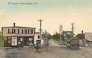
Salem, New Hampshire
Encyclopedia
Salem is a town in Rockingham County
, New Hampshire
, United States
. The population was 28,776 at the 2010 census. Salem is a marketing and distributing center north of Boston
, with a major amusement attraction, Canobie Lake Park
, and a large shopping mall
, the Mall at Rockingham Park
.
, Massachusetts
, or "Methuen District." In 1741, when the boundary line between Massachusetts
and New Hampshire
was re-established, the "North Parish" became part of New Hampshire, and was given the name "Salem," taken from nearby Salem
, Massachusetts
. It was incorporated in 1750 by Colonial
Governor Benning Wentworth
.
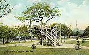
 In 1902, Canobie Lake Park
was established in Salem by the Massachusetts Northeast Street Railway Company, to encourage leisure excursions on its trolley
s. The plan was successful, and the enterprise quickly became one of the leading resorts of its type in New England
. Crowds arrived from all over, including the nearby mill town
s of Haverhill
, Lawrence
, Lowell
and Methuen
in Massachusetts, and Manchester
and Nashua
in New Hampshire. Factory workers and others found respite strolling along tree-lined promenades, between flower-beds or beside the lake. Rides, arcades and a dance hall
provided lively entertainments. The rise of the automobile
, however, brought the decline of the trolley. But Canobie Lake Park, one of the few former street railway amusement resorts still in existence, continues to be popular.
Other features of Salem's tourism
history include Rockingham Park
Race Track, the first horse race track in New England, and "America's Stonehenge
", a curiosity (formerly "Mystery Hill"). A recent attraction in town is the Icenter, a skating arena.
Starting in the 1950s, Salem developed rapidly as part of Greater Boston
, with suburban-style residential neighborhoods and a long strip of commercial development along NH Route 28
. Recent (c. 2006) commercial construction has continued to focus on Route 28, as well as on the commercial zone off Exit 2 on Interstate 93
.
, the town has a total area of 25.9 square miles (67.1 km²), of which 24.7 sq mi (64 km²) is land and 1.2 sq mi (3.1 km²) is water, comprising 4.49% of the town. Salem is drained by the Spicket River
and Policy Brook. Canobie Lake
is on the western boundary, Arlington Mill Reservoir
is in the north, and World End Pond is in the southeast. The highest point in Salem is the summit of Gordons Hill, at 380 feet (115.8 m) above sea level
, along the town's western border.
 At the 2000 census
, there were 28,112 people, 10,402 households and 7,603 families residing in the town. The population density
was 1,138.0 per square mile (439.4/km²). There were 10,866 housing units at an average density of 439.9 per square mile (169.9/km²). The racial makeup of the town was 95.01% White, 0.55% African American, 0.21% Native American, 2.27% Asian, 0.06% Pacific Islander, 0.83% from other races
, and 1.07% from two or more races. Hispanic or Latino of any race were 1.96% of the population.
There were 10,402 households of which 34.3% had children under the age of 18 living with them, 60.6% were married couples
living together, 8.7% had a female householder with no husband present, and 26.9% were non-families. 21.2% of all households were made up of individuals and 7.5% had someone living alone who was 65 years of age or older. The average household size was 2.69 and the average family size was 3.16.
 Age distribution was 25.3% under the age of 18, 6.2% from 18 to 24, 31.7% from 25 to 44, 25.3% from 45 to 64, and 11.5% who were 65 years of age or older. The median age was 38 years. For every 100 females there were 99.1 males. For every 100 females age 18 and over, there were 96.9 males.
The median household income
was $58,090, and the median family income was $67,278. Males had a median income of $46,330 versus $31,031 for females. The per capita income
for the town was $26,170. About 3.1% of families and 4.1% of the population were below the poverty line, including 5.1% of those under age 18 and 7.6% of those age 65 or over.
High School
Administration
Race Track, located in Salem, as mentioned in the film The Sting
starring Paul Newman
and Robert Redford
, was central to that film's plot.
Scenes from the original The Thomas Crown Affair
were filmed at the Salem glider airport, which is now Campbell's Scottish Highlands Golf Course.
Rockingham County, New Hampshire
-Demographics:As of the census of 2000, there were 277,359 people, 104,529 households, and 74,320 families residing in the county. The population density was 399 people per square mile . There were 113,023 housing units at an average density of 163 per square mile...
, New Hampshire
New Hampshire
New Hampshire is a state in the New England region of the northeastern United States of America. The state was named after the southern English county of Hampshire. It is bordered by Massachusetts to the south, Vermont to the west, Maine and the Atlantic Ocean to the east, and the Canadian...
, United States
United States
The United States of America is a federal constitutional republic comprising fifty states and a federal district...
. The population was 28,776 at the 2010 census. Salem is a marketing and distributing center north of Boston
Boston
Boston is the capital of and largest city in Massachusetts, and is one of the oldest cities in the United States. The largest city in New England, Boston is regarded as the unofficial "Capital of New England" for its economic and cultural impact on the entire New England region. The city proper had...
, with a major amusement attraction, Canobie Lake Park
Canobie Lake Park
Canobie Lake Park is an amusement park located in Salem, New Hampshire, United States, about north of Boston, Massachusetts.-Description:Canobie Lake Park opened on August 23, 1902, as a trolley park for the Massachusetts Northeast Street Railway Company. The amusement park has opened every summer...
, and a large shopping mall
Shopping mall
A shopping mall, shopping centre, shopping arcade, shopping precinct or simply mall is one or more buildings forming a complex of shops representing merchandisers, with interconnecting walkways enabling visitors to easily walk from unit to unit, along with a parking area — a modern, indoor version...
, the Mall at Rockingham Park
Mall at Rockingham Park
The Mall at Rockingham Park is located in Salem, New Hampshire. It is the largest shopping mall in New Hampshire, as well as northern New England, with of floor space. The mall is adjacent to the Rockingham Park race track in Salem, and was the state's third shopping mall to be built...
.
History
The area was first settled in 1652. As early as 1736, Salem was the "North Parish" of MethuenMethuen, Massachusetts
Methuen is a city in Essex County, Massachusetts, United States. The population was 43,789 at the 2000 census.-History:Methuen was first settled in 1642 and was officially incorporated in 1726; it is named for the British diplomat Sir Paul Methuen. Methuen was originally part of Haverhill,...
, Massachusetts
Massachusetts
The Commonwealth of Massachusetts is a state in the New England region of the northeastern United States of America. It is bordered by Rhode Island and Connecticut to the south, New York to the west, and Vermont and New Hampshire to the north; at its east lies the Atlantic Ocean. As of the 2010...
, or "Methuen District." In 1741, when the boundary line between Massachusetts
Massachusetts
The Commonwealth of Massachusetts is a state in the New England region of the northeastern United States of America. It is bordered by Rhode Island and Connecticut to the south, New York to the west, and Vermont and New Hampshire to the north; at its east lies the Atlantic Ocean. As of the 2010...
and New Hampshire
New Hampshire
New Hampshire is a state in the New England region of the northeastern United States of America. The state was named after the southern English county of Hampshire. It is bordered by Massachusetts to the south, Vermont to the west, Maine and the Atlantic Ocean to the east, and the Canadian...
was re-established, the "North Parish" became part of New Hampshire, and was given the name "Salem," taken from nearby Salem
Salem, Massachusetts
Salem is a city in Essex County, Massachusetts, United States. The population was 40,407 at the 2000 census. It and Lawrence are the county seats of Essex County...
, Massachusetts
Massachusetts
The Commonwealth of Massachusetts is a state in the New England region of the northeastern United States of America. It is bordered by Rhode Island and Connecticut to the south, New York to the west, and Vermont and New Hampshire to the north; at its east lies the Atlantic Ocean. As of the 2010...
. It was incorporated in 1750 by Colonial
Colony
In politics and history, a colony is a territory under the immediate political control of a state. For colonies in antiquity, city-states would often found their own colonies. Some colonies were historically countries, while others were territories without definite statehood from their inception....
Governor Benning Wentworth
Benning Wentworth
Benning Wentworth was the colonial governor of New Hampshire from 1741 to 1766.-Biography:The eldest child of the John Wentworth who had been Lieutenant Governor, he was born and died in Portsmouth, New Hampshire. Wentworth graduated from Harvard College in 1715...
.
Canobie Lake Park
Canobie Lake Park is an amusement park located in Salem, New Hampshire, United States, about north of Boston, Massachusetts.-Description:Canobie Lake Park opened on August 23, 1902, as a trolley park for the Massachusetts Northeast Street Railway Company. The amusement park has opened every summer...
was established in Salem by the Massachusetts Northeast Street Railway Company, to encourage leisure excursions on its trolley
Tram
A tram is a passenger rail vehicle which runs on tracks along public urban streets and also sometimes on separate rights of way. It may also run between cities and/or towns , and/or partially grade separated even in the cities...
s. The plan was successful, and the enterprise quickly became one of the leading resorts of its type in New England
New England
New England is a region in the northeastern corner of the United States consisting of the six states of Maine, New Hampshire, Vermont, Massachusetts, Rhode Island, and Connecticut...
. Crowds arrived from all over, including the nearby mill town
Mill town
A mill town, also known as factory town or mill village, is typically a settlement that developed around one or more mills or factories .- United Kingdom:...
s of Haverhill
Haverhill, Massachusetts
Haverhill is a city in Essex County, Massachusetts, United States. The population was 60,879 at the 2010 census.Located on the Merrimack River, it began as a farming community that would evolve into an important industrial center, beginning with sawmills and gristmills run by water power. In the...
, Lawrence
Lawrence, Massachusetts
Lawrence is a city in Essex County, Massachusetts, United States on the Merrimack River. According to the 2010 U.S. Census, the city had a total population of 76,377. Surrounding communities include Methuen to the north, Andover to the southwest, and North Andover to the southeast. It and Salem are...
, Lowell
Lowell, Massachusetts
Lowell is a city in Middlesex County, Massachusetts, USA. According to the 2010 census, the city's population was 106,519. It is the fourth largest city in the state. Lowell and Cambridge are the county seats of Middlesex County...
and Methuen
Methuen, Massachusetts
Methuen is a city in Essex County, Massachusetts, United States. The population was 43,789 at the 2000 census.-History:Methuen was first settled in 1642 and was officially incorporated in 1726; it is named for the British diplomat Sir Paul Methuen. Methuen was originally part of Haverhill,...
in Massachusetts, and Manchester
Manchester, New Hampshire
Manchester is the largest city in the U.S. state of New Hampshire, the tenth largest city in New England, and the largest city in northern New England, an area comprising the states of Maine, New Hampshire, and Vermont. It is in Hillsborough County along the banks of the Merrimack River, which...
and Nashua
Nashua, New Hampshire
-Climate:-Demographics:As of the census of 2010, there were 86,494 people, 35,044 households, and 21,876 families residing in the city. The population density was 2,719.9 people per square mile . There were 37,168 housing units at an average density of 1,202.8 per square mile...
in New Hampshire. Factory workers and others found respite strolling along tree-lined promenades, between flower-beds or beside the lake. Rides, arcades and a dance hall
Dance hall
Dance hall in its general meaning is a hall for dancing. From the earliest years of the twentieth century until the early 1960s, the dance hall was the popular forerunner of the discothèque or nightclub...
provided lively entertainments. The rise of the automobile
Automobile
An automobile, autocar, motor car or car is a wheeled motor vehicle used for transporting passengers, which also carries its own engine or motor...
, however, brought the decline of the trolley. But Canobie Lake Park, one of the few former street railway amusement resorts still in existence, continues to be popular.
Other features of Salem's tourism
Tourism
Tourism is travel for recreational, leisure or business purposes. The World Tourism Organization defines tourists as people "traveling to and staying in places outside their usual environment for not more than one consecutive year for leisure, business and other purposes".Tourism has become a...
history include Rockingham Park
Rockingham Park
Rockingham Park is a horse racing establishment in Salem, New Hampshire, in the United States. First built in 1906, it was used as an area for many to gamble on the weekends. Seabiscuit raced there in 1935 and 1936, and Mom's Command ran in her first race and gained her first victory there in...
Race Track, the first horse race track in New England, and "America's Stonehenge
America's Stonehenge
America's Stonehenge is an archaeological site consisting of a number of large rocks and stone structures scattered around roughly within the town of Salem, New Hampshire in the northeast United States. America's Stonehenge is open to the public for a fee...
", a curiosity (formerly "Mystery Hill"). A recent attraction in town is the Icenter, a skating arena.
Starting in the 1950s, Salem developed rapidly as part of Greater Boston
Greater Boston
Greater Boston is the area of the Commonwealth of Massachusetts surrounding the city of Boston. Due to ambiguity in usage, the size of the area referred to can be anywhere between that of the metropolitan statistical area of Boston and that of the city's combined statistical area which includes...
, with suburban-style residential neighborhoods and a long strip of commercial development along NH Route 28
New Hampshire Route 28
New Hampshire Route 28 is an north–south state highway in southeastern New Hampshire. It connects the town of Ossipee in east-central New Hampshire with Salem on the Massachusetts border....
. Recent (c. 2006) commercial construction has continued to focus on Route 28, as well as on the commercial zone off Exit 2 on Interstate 93
Interstate 93
Interstate 93 is an Interstate Highway in the New England section of the United States. Its southern terminus is in Canton, Massachusetts, in the Boston metropolitan area, at Interstate 95; its northern terminus is near St. Johnsbury, Vermont, at Interstate 91...
.
Geography
According to the United States Census BureauUnited States Census Bureau
The United States Census Bureau is the government agency that is responsible for the United States Census. It also gathers other national demographic and economic data...
, the town has a total area of 25.9 square miles (67.1 km²), of which 24.7 sq mi (64 km²) is land and 1.2 sq mi (3.1 km²) is water, comprising 4.49% of the town. Salem is drained by the Spicket River
Spicket River
The Spicket River is a river located in New Hampshire and Massachusetts in the United States. It is a tributary of the Merrimack River, part of the Gulf of Maine watershed. It is sometimes spelled "Spickett"....
and Policy Brook. Canobie Lake
Canobie Lake
Canobie Lake is a body of water located in Rockingham County in southern New Hampshire, United States, in the towns of Salem and Windham. It is approximately long, and on average wide, though two arms of the lake combine to produce a width of at the lake's center. Canobie Lake Park, an...
is on the western boundary, Arlington Mill Reservoir
Arlington Mill Reservoir
Arlington Mill Reservoir, known locally as Arlington Pond, is a impoundment located in Rockingham County in southern New Hampshire, United States, in the town of Salem. It is located along the Spicket River, a small stream that flows south to the Merrimack River in Lawrence, Massachusetts....
is in the north, and World End Pond is in the southeast. The highest point in Salem is the summit of Gordons Hill, at 380 feet (115.8 m) above sea level
Sea level
Mean sea level is a measure of the average height of the ocean's surface ; used as a standard in reckoning land elevation...
, along the town's western border.
Demographics
Census
A census is the procedure of systematically acquiring and recording information about the members of a given population. It is a regularly occurring and official count of a particular population. The term is used mostly in connection with national population and housing censuses; other common...
, there were 28,112 people, 10,402 households and 7,603 families residing in the town. The population density
Population density
Population density is a measurement of population per unit area or unit volume. It is frequently applied to living organisms, and particularly to humans...
was 1,138.0 per square mile (439.4/km²). There were 10,866 housing units at an average density of 439.9 per square mile (169.9/km²). The racial makeup of the town was 95.01% White, 0.55% African American, 0.21% Native American, 2.27% Asian, 0.06% Pacific Islander, 0.83% from other races
Race (United States Census)
Race and ethnicity in the United States Census, as defined by the Federal Office of Management and Budget and the United States Census Bureau, are self-identification data items in which residents choose the race or races with which they most closely identify, and indicate whether or not they are...
, and 1.07% from two or more races. Hispanic or Latino of any race were 1.96% of the population.
There were 10,402 households of which 34.3% had children under the age of 18 living with them, 60.6% were married couples
Marriage
Marriage is a social union or legal contract between people that creates kinship. It is an institution in which interpersonal relationships, usually intimate and sexual, are acknowledged in a variety of ways, depending on the culture or subculture in which it is found...
living together, 8.7% had a female householder with no husband present, and 26.9% were non-families. 21.2% of all households were made up of individuals and 7.5% had someone living alone who was 65 years of age or older. The average household size was 2.69 and the average family size was 3.16.
The median household income
Median household income
The median household income is commonly used to generate data about geographic areas and divides households into two equal segments with the first half of households earning less than the median household income and the other half earning more...
was $58,090, and the median family income was $67,278. Males had a median income of $46,330 versus $31,031 for females. The per capita income
Per capita income
Per capita income or income per person is a measure of mean income within an economic aggregate, such as a country or city. It is calculated by taking a measure of all sources of income in the aggregate and dividing it by the total population...
for the town was $26,170. About 3.1% of families and 4.1% of the population were below the poverty line, including 5.1% of those under age 18 and 7.6% of those age 65 or over.
Education
Colleges- Hesser CollegeHesser CollegeHesser College is a for-profit college with several campuses in New Hampshire. It is owned by Kaplan, Inc. The college offers associate and bachelor degrees in the fields of early childhood education, criminal justice, general studies, business and various art programs. The college claims a...
- Southern New Hampshire UniversitySouthern New Hampshire UniversitySouthern New Hampshire University, also known as SNHU, is a private university in Manchester and Hooksett, New Hampshire. The university is accredited by the Commission on Institutions of Higher Education of the New England Association of Schools and Colleges, and also has numerous specialized...
(Salem satellite campus)
High School
- Salem High School
Administration
Salem in popular culture
Rockingham ParkRockingham Park
Rockingham Park is a horse racing establishment in Salem, New Hampshire, in the United States. First built in 1906, it was used as an area for many to gamble on the weekends. Seabiscuit raced there in 1935 and 1936, and Mom's Command ran in her first race and gained her first victory there in...
Race Track, located in Salem, as mentioned in the film The Sting
The Sting
The Sting is a 1973 American caper film set in September 1936 that involves a complicated plot by two professional grifters to con a mob boss . The film was directed by George Roy Hill, who previously directed Newman and Redford in the western Butch Cassidy and the Sundance Kid.Created by...
starring Paul Newman
Paul Newman
Paul Leonard Newman was an American actor, film director, entrepreneur, humanitarian, professional racing driver and auto racing enthusiast...
and Robert Redford
Robert Redford
Charles Robert Redford, Jr. , better known as Robert Redford, is an American actor, film director, producer, businessman, environmentalist, philanthropist, and founder of the Sundance Film Festival. He has received two Oscars: one in 1981 for directing Ordinary People, and one for Lifetime...
, was central to that film's plot.
Scenes from the original The Thomas Crown Affair
The Thomas Crown Affair (1968 film)
The Thomas Crown Affair is a 1968 film by Norman Jewison starring Steve McQueen and Faye Dunaway. It was nominated for two Academy Awards and won the Award for Best Song with Michel Legrand's "Windmills of Your Mind"...
were filmed at the Salem glider airport, which is now Campbell's Scottish Highlands Golf Course.
Points of interest
- America's StonehengeAmerica's StonehengeAmerica's Stonehenge is an archaeological site consisting of a number of large rocks and stone structures scattered around roughly within the town of Salem, New Hampshire in the northeast United States. America's Stonehenge is open to the public for a fee...
- Canobie Lake ParkCanobie Lake ParkCanobie Lake Park is an amusement park located in Salem, New Hampshire, United States, about north of Boston, Massachusetts.-Description:Canobie Lake Park opened on August 23, 1902, as a trolley park for the Massachusetts Northeast Street Railway Company. The amusement park has opened every summer...
- Rockingham ParkRockingham ParkRockingham Park is a horse racing establishment in Salem, New Hampshire, in the United States. First built in 1906, it was used as an area for many to gamble on the weekends. Seabiscuit raced there in 1935 and 1936, and Mom's Command ran in her first race and gained her first victory there in...
- Mall at Rockingham ParkMall at Rockingham ParkThe Mall at Rockingham Park is located in Salem, New Hampshire. It is the largest shopping mall in New Hampshire, as well as northern New England, with of floor space. The mall is adjacent to the Rockingham Park race track in Salem, and was the state's third shopping mall to be built...
- Manchester and Lawrence RailroadManchester and Lawrence RailroadThe Manchester and Lawrence Railroad was a railroad company that was chartered in New Hampshire by businessmen from Manchester, to build a rail line from that city to the Massachusetts state line....
rail trail