

Anahim hotspot
Encyclopedia
The Anahim hotspot is a volcanic
hotspot
in central British Columbia
, Canada
. It is situated on the Interior Plateau
, a large region that lies between the Cariboo
and Monashee Mountains
to the east, and the Hazelton Mountains
, Coast Mountains
and Cascade Range
to the west. As a geologic
hotspot, it is a place that has experienced active volcanism over a long period of time.
Identifiable from the mid-Miocene
period, it has recorded changes in the western-moving North American Plate
because it is believed to have been relatively stationary for tens of millions of years. Since then it has formed a line of volcano
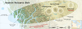
es called the Anahim Volcanic Belt
, stretching from the coast to the Interior Plateau near Quesnel
. Each of the volcanoes was once over the hotspot, but migration of the North American Plate has pulled the volcanoes away from the hotspot's magmatic source at a rate of 2 cm (0.78740157480315 in) to 3.3 cm (1.3 in) per year. As a result, the volcanoes are progressively older to the west. The composition of magma to the volcanoes and its supply change with time as the volcanoes grow over the hotspot and migrate away.
volcanic complex on what was then the coast of British Columbia, now heavily eroded
to form the ~20 km (12 mi) long Bella Bella
and ~6 km (4 mi) long Gale Passage dike swarm
s. Individual dikes are as thick as 20 m (66 ft) and have basalt
, trachyte
, and comendite
compositions. The converging dikes may mark the first appearance of the Anahim hotspot. During the early to middle Miocene
era, the passage of the Anahim hotspot beneath the range created the central Coast Mountains
; this orogeny
caused reactions with the North American Plate
in late Miocene-Pliocene
time.
 During a period of 2 million years, extrusion of highly fluid basic and silicic lava flows built up the gently sloping Late Miocene Rainbow Range
. It is one of three large peralkaline shield volcano
es that lie on an east-west trend in west-central British Columbia. Alkaline and peralkaline lava flows from four volcanic episodes make up an 845 m (2,772 ft) composite section on the north flank of the shield volcano. Basal comenditic trachyte
flows are unconformably overlain by flows and flow breccia
s of mugearite. A sequence of 40–60 m (130–200 ft) thick columnar-jointed comendite flows blankets the underlying units and gives the volcano its shield-like form. Hawaiite
dike
s, plugs
, and minor capping flows are scattered over the north flank. Comendite flows, which commonly have a glassy selvage at the base, account for 75% of the lavas in the flank zone. The Rainbow shield was erupting until 6.7 million years ago.
 Over a period of 2 million years, extrusion of highly fluid basic and silicic lava flows built up the gently sloping Late Miocene-to-Early Pliocene
Ilgachuz Range
. It is the second youngest of the three large peralkine shield volcanoes that lie on an east-west trend in west-central British Columbia with a diameter of 25 km (16 mi). The Ilgachuz shield was created by two chemically separate magmatic periods; an early complex series of trachyte
and rhyolite
eruptions and late extrusion of a sequence of basalt
ic lava flows. The surface of the outer shield, cut by deeply incised radial valleys, rises to a complexly dissected summit area where remnants of a small central caldera
and numerous felsic
domes and basalt
ic feeders are exposed. The outer flanks of the shield merge with flat-lying basalt of the Chilcotin Group, which is thought to have been formed by a back-arc basin
behind the Cascadia subduction zone
. The volcano was spewing out ash
, cinder
, pumice
, rhyolite
, trachyte
and basalt
ic lava up until 4 million years ago.
 During a period of 3 million years, extrusion of undersaturated trachyte
flows built up the gently sloping Late Pliocene-to-Pleistocene
Itcha Range
. It is the easternmost and youngest of the three large felsic
shield volcanoes lying on an east-west trend in west-central British Columbia. It has a diameter of 15 km (9 mi). The broad scale morphology of the Itcha shield is given by the extensive lateral distribution of thick (70–150 m (230–490 ft)) felsic flows which erupted from fissure vent
s around a central vent to cover an area of 330 km³ (79 cu mi). Most late-stage lavas capping the Itcha shield complex were erupted from cinder cone
s, tuff rings, and fissure vent
s in the eastern half of the complex about 80,000 years ago.
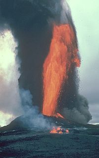
 Throughout the Holocene
epoch, the Anahim hotspot has energized numerous volcanoes. This volcanic activity has produced numerous Hawaiian eruption
s, which created lava fountain
s, small cinder cones and lava flows. The youngest expression of the Anahim hotspot is Nazko Cone
, which formed about 340,000 years ago. The most recent eruptive activity at Nazko Cone occurred about 7,200 years ago. This is very recent in geological terms, suggesting that the volcano may yet have some ongoing volcanic activity. The Rainbow Range is the largest Anahim volcano, although Nazko Cone is now the site of the most intense volcanic activity, located directly on top of the Anahim hotspot at . Its last eruption started with an eruption of two different progressions of runny lava flow
s, which resulted in an older, grey basalt becoming overlain by a younger, darker black basaltic lava flow. The passive eruptions were followed by a period of explosive eruption
s. This explosive activity built three overlying cinder cones that broke by the two lava flows near the end of the explosive phase of activity. The last phase of explosive activity spread tephra
to the north and east of the cones. The deepest deposits near the cone are less than 3 m (10 ft); that they thin to less than a few centimetres only a few kilometres away, suggests that the explosive eruptions at Nazko Cone were fairly small. However, the last eruption from Nazko Cone could have started forest fire
s, since there is charcoal
inside the tephra
layer.
 Analysis of the chemical composition of the lavas gives important clues about the source and dynamics of the hotspot plume. Where hotspots occur under thick continental crust
, basaltic magma
is trapped in the less dense continental crust, which is heated and melts to form rhyolite
s. These rhyolites can be quite hot and form violent eruptions, despite their low water content. Such rhyolitic magma can be found at the western part of the Anahim Volcanic Belt, which contrasts the more basaltic material in the Nazko Cone area. This suggests that as the North American Plate moves westwards, the Anahim hotspot underlies thinner continental crust
. This hypothesis has been verified by observation of the crustal regime in other compression margins – the thickest granitic
structures are found near the margin itself, with the North American Plate becoming less compressed in regions away from the margin. In this case, the thinner crust would represent briefer travel time, thus reducing the time available for magma differentiation, whose end products are rhyolites. As most magma is basaltic in origin, the eruption would therefore contain more basaltic materials. A few igneous rock
types with composition unlike basalt, such as nephelinite
, do occur at the small basaltic cinder cones and flows but are extremely rare.
 Basalt
ic lava flows have a high ferromagnesian (iron and magnesium) content and erupt at temperatures between 1000°C and 1200°C; these values are higher than those of other common igneous rock
s. Due to the high temperature of this lava flow, the lava would be extremely fluid
(it has low viscosity
), allowing the lava to travel long distances from the magma source (the volcano or vent). These extremely fluid lavas have flow speeds that depend heavily on underlying terrain, with a maximum of almost 60 kilometres per hour (37 mph) in underground lava channel
s. Flow independent of such channels and tubes moves quite a bit slower, averaging speeds of 1.6 km (0.994196378639691 mi) per hour. However, this flow speed changes considerably within the flow, with speeds depending heavily on depth and degree of cooling that the flow has experienced (essentially distance from the vent). Although the Nazko area flows would not be highly basaltic like those found in Iceland
or Hawaii
, lower depths are unlikely as viscosity is normally higher.
A few volcanic centers in the vicinity of the Bella Bella and Gale Passage dike swarms, such as Helmet Peak and Kitasu Hill
, which are members of the Milbanke Sound Group
, may represent the westernmost of the Anahim volcanoes, but their ages are significantly different, provoking on-going questions about their origin and connection to other regional volcanic activity. However, many volcanoes in that center are believed to be monogenetic
, suggesting a monogenetic volcanic field
may be responsible.
s hypothesize that the Anahim hotspot is linked with an upper mantle plume
(miniplume
) rather than the more common deep mantle plume because of the small size of the Bella Bella and Gale Passage dike swarm
s. Others prefer to attribute the hotspot to tensional cracking of the lithosphere
above the northern edge of the subducting
Juan de Fuca
and Explorer
plates at the Cascadia subduction zone
or interpreted as an edge effect of the subducting plates in the mantle
. None of the hypotheses so far suggested is without critics. Part of the controversy is due to the rather sudden appearance of the hotspot in the geologic record. A number of hotspot models have been suggested to explain tensional cracking origins, however. Some of Earth's more prominent hotspots were unified along with flood basalt
volcanism and continent
ial rift
ing. While mafic
lava flows appear to merge laterally with the less silicon
-undersaturated lavas of the Chilcotin Group surrounding the Anahim Volcanic Belt
, the particular nature and connection between the Anahim hotspot and the Chilcotin Group is unknown. Volcanic chemistry and isotopic composition of the Anahim Volcanic Belt
do not distinguish between either a rift
or a hotspot setting.
 Volcanism appears to have ceased in the western parts of the Anahim Volcanic Belt
, but if that is correct, future eruptive activity can be expected in the Nazko Cone
area and east of it. Future eruptions from the Anahim hotspot are most likely in the creation of basalt
ic cinder cone
s, but eruptions of less mafic
magma, typical of the eastern portions of the Anahim Volcanic Belt, cannot be ruled out.
away from the British Columbia Coast
. A series of <3.0 magnitude earthquakes began October 9, 2007 with its epicenter
in the McNaughton Lake region near Nazko Cone, which could signal the resumption of intense subterranean volcanic activity in the area. Thirty-four such <3.0 magnitude earthquakes were observed on October 10, 2007 alone. Since then more than 1,000 small earthquakes have been recorded. They are thought to have originated 25 km (15.5 mi) below the surface, but none of them have been felt by people. The cause of this seismic activity
is believed to be the upwelling of 500000 m³ (653,975.3 cu yd) of magma
, because the area is not close to any faults or tectonic plate
boundaries. This is the first indication of potential volcanic activity in Canada since around 1830 to 1850 in northwestern British Columbia.
The recent earthquake swarms in the Anahim hotspot have aroused much interest from volcanologist
s and seismologist
s since they began on October 9, 2007. More than 1,000 earthquakes have now been detected, and seven stations are now monitoring the area for further activity. The region's earthquake swarms have given rise to speculation of a possible eruption, a possibility estimated around 10%. An eruption in the region would not cause many fatalities, due to the region's remoteness, but people engaged in logging and ranching in the region are at risk. The greatest threats would be from forest fire
s and possible health risks to those in the area if volcanic gas
ses or ash columns
were released. Also, the Anahim hotspot is situated in the immediate proximity of a major air traffic route
, and volcanic ash reduces visibility and can cause jet engine failure as well as damage to other aircraft systems.
Volcano
2. Bedrock3. Conduit 4. Base5. Sill6. Dike7. Layers of ash emitted by the volcano8. Flank| 9. Layers of lava emitted by the volcano10. Throat11. Parasitic cone12. Lava flow13. Vent14. Crater15...
hotspot
Hotspot (geology)
The places known as hotspots or hot spots in geology are volcanic regions thought to be fed by underlying mantle that is anomalously hot compared with the mantle elsewhere. They may be on, near to, or far from tectonic plate boundaries. There are two hypotheses to explain them...
in central British Columbia
British Columbia
British Columbia is the westernmost of Canada's provinces and is known for its natural beauty, as reflected in its Latin motto, Splendor sine occasu . Its name was chosen by Queen Victoria in 1858...
, Canada
Canada
Canada is a North American country consisting of ten provinces and three territories. Located in the northern part of the continent, it extends from the Atlantic Ocean in the east to the Pacific Ocean in the west, and northward into the Arctic Ocean...
. It is situated on the Interior Plateau
Interior Plateau
The Interior Plateau comprises a large region of central British Columbia, and lies between the Cariboo and Monashee Mountains on the east, and the Hazelton Mountains, Coast Mountains and Cascade Range on the west. The continuation of the plateau into the United States is known there as the...
, a large region that lies between the Cariboo
Cariboo Mountains
The Cariboo Mountains are the northernmost subrange of the Columbia Mountains, which run down into the Spokane, Washington area of the United States and include the Selkirks, Monashees and Purcells. The Cariboo Mountains are entirely within the province of British Columbia, Canada. The range is...
and Monashee Mountains
Monashee Mountains
The Monashee Mountains are a mountain range mostly in British Columbia, Canada, extending into the U.S. state of Washington. They stretch from north to south and from east to west. They are a subrange of the Columbia Mountains...
to the east, and the Hazelton Mountains
Hazelton Mountains
The Hazelton Mountains are a grouping of mountain ranges on the inland lee of the Kitimat Ranges of the Coast Mountains in northwestern British Columbia, Canada, spanning the area of Hazelton, British Columbia south to the Nechako Reservoir...
, Coast Mountains
Coast Mountains
The Coast Mountains are a major mountain range, in the Pacific Coast Ranges, of western North America, extending from southwestern Yukon through the Alaska Panhandle and virtually all of the Coast of British Columbia. They are so-named because of their proximity to the sea coast, and are often...
and Cascade Range
Cascade Range
The Cascade Range is a major mountain range of western North America, extending from southern British Columbia through Washington and Oregon to Northern California. It includes both non-volcanic mountains, such as the North Cascades, and the notable volcanoes known as the High Cascades...
to the west. As a geologic
Geology
Geology is the science comprising the study of solid Earth, the rocks of which it is composed, and the processes by which it evolves. Geology gives insight into the history of the Earth, as it provides the primary evidence for plate tectonics, the evolutionary history of life, and past climates...
hotspot, it is a place that has experienced active volcanism over a long period of time.
Identifiable from the mid-Miocene
Miocene
The Miocene is a geological epoch of the Neogene Period and extends from about . The Miocene was named by Sir Charles Lyell. Its name comes from the Greek words and and means "less recent" because it has 18% fewer modern sea invertebrates than the Pliocene. The Miocene follows the Oligocene...
period, it has recorded changes in the western-moving North American Plate
North American Plate
The North American Plate is a tectonic plate covering most of North America, Greenland, Cuba, Bahamas, and parts of Siberia, Japan and Iceland. It extends eastward to the Mid-Atlantic Ridge and westward to the Chersky Range in eastern Siberia. The plate includes both continental and oceanic crust...
because it is believed to have been relatively stationary for tens of millions of years. Since then it has formed a line of volcano
Volcano
2. Bedrock3. Conduit 4. Base5. Sill6. Dike7. Layers of ash emitted by the volcano8. Flank| 9. Layers of lava emitted by the volcano10. Throat11. Parasitic cone12. Lava flow13. Vent14. Crater15...
es called the Anahim Volcanic Belt
Anahim Volcanic Belt
The Anahim Volcanic Belt is a long volcanic belt, stretching from just north of Vancouver Island to near Quesnel, British Columbia, Canada. The Anahim Volcanic Belt has had three main magmatic episodes: 15–13 Ma, 9–6 Ma, and 3–1 Ma. The volcanoes generally become younger eastward at a rate of to ...
, stretching from the coast to the Interior Plateau near Quesnel
Quesnel, British Columbia
-Demographics:Quesnel had a population of 9,326 people in 2006, which was a decrease of 7.1% from the 2001 census count. The median household income in 2005 for Quesnel was $54,044, which is slightly above the British Columbia provincial average of $52,709....
. Each of the volcanoes was once over the hotspot, but migration of the North American Plate has pulled the volcanoes away from the hotspot's magmatic source at a rate of 2 cm (0.78740157480315 in) to 3.3 cm (1.3 in) per year. As a result, the volcanoes are progressively older to the west. The composition of magma to the volcanoes and its supply change with time as the volcanoes grow over the hotspot and migrate away.
Dike swarm emplacements
The Anahim hotspot has a long history. About 13 and 12 million years ago, the Anahim hotspot created a peralkalinePeralkaline
Peralkaline rocks include those igneous rocks which have a deficiency of aluminium such that sodium and potassium are in excess of that needed for feldspar. The presence of aegerine and riebeckite are indicative of peralkaline conditions....
volcanic complex on what was then the coast of British Columbia, now heavily eroded
Erosion
Erosion is when materials are removed from the surface and changed into something else. It only works by hydraulic actions and transport of solids in the natural environment, and leads to the deposition of these materials elsewhere...
to form the ~20 km (12 mi) long Bella Bella
Bella Bella, British Columbia
Bella Bella, also known as Waglisla, is an unincorporated community and Indian Reserve community located within Bella Bella Indian Reserve No. 1 on the east coast of Campbell Island in the Central Coast region of British Columbia, Canada. Bella Bella is located north of Port Hardy, on Vancouver...
and ~6 km (4 mi) long Gale Passage dike swarm
Dike swarm
A dike swarm or dyke swarm is a large geological structure consisting of a major group of parallel, linear, or radially oriented dikes intruded within continental crust. They consist of several to hundreds of dikes emplaced more or less contemporaneously during a single intrusive event and are...
s. Individual dikes are as thick as 20 m (66 ft) and have basalt
Basalt
Basalt is a common extrusive volcanic rock. It is usually grey to black and fine-grained due to rapid cooling of lava at the surface of a planet. It may be porphyritic containing larger crystals in a fine matrix, or vesicular, or frothy scoria. Unweathered basalt is black or grey...
, trachyte
Trachyte
Trachyte is an igneous volcanic rock with an aphanitic to porphyritic texture. The mineral assemblage consists of essential alkali feldspar; relatively minor plagioclase and quartz or a feldspathoid such as nepheline may also be present....
, and comendite
Comendite
Comendite is a hard, peralkaline igneous rock, a type of light blue grey rhyolite. Phenocrysts are sodic sanidine with minor albite and bipyrimidal quartz. Comendite occurs in the mountains Tibrogargan, Coonowrin, Tunbubudla, Coochin, Saddleback, Tibberoowuccum and Ngungun in the Glass House...
compositions. The converging dikes may mark the first appearance of the Anahim hotspot. During the early to middle Miocene
Miocene
The Miocene is a geological epoch of the Neogene Period and extends from about . The Miocene was named by Sir Charles Lyell. Its name comes from the Greek words and and means "less recent" because it has 18% fewer modern sea invertebrates than the Pliocene. The Miocene follows the Oligocene...
era, the passage of the Anahim hotspot beneath the range created the central Coast Mountains
Coast Mountains
The Coast Mountains are a major mountain range, in the Pacific Coast Ranges, of western North America, extending from southwestern Yukon through the Alaska Panhandle and virtually all of the Coast of British Columbia. They are so-named because of their proximity to the sea coast, and are often...
; this orogeny
Orogeny
Orogeny refers to forces and events leading to a severe structural deformation of the Earth's crust due to the engagement of tectonic plates. Response to such engagement results in the formation of long tracts of highly deformed rock called orogens or orogenic belts...
caused reactions with the North American Plate
North American Plate
The North American Plate is a tectonic plate covering most of North America, Greenland, Cuba, Bahamas, and parts of Siberia, Japan and Iceland. It extends eastward to the Mid-Atlantic Ridge and westward to the Chersky Range in eastern Siberia. The plate includes both continental and oceanic crust...
in late Miocene-Pliocene
Pliocene
The Pliocene Epoch is the period in the geologic timescale that extends from 5.332 million to 2.588 million years before present. It is the second and youngest epoch of the Neogene Period in the Cenozoic Era. The Pliocene follows the Miocene Epoch and is followed by the Pleistocene Epoch...
time.
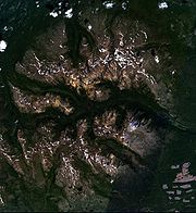
Rainbow Range eruptive period
Rainbow Range (Coast Mountains)
The Rainbow Range, formerly known as the Rainbow Mountains, is a mountain range in British Columbia, Canada, located northwest of Anahim Lake...
. It is one of three large peralkaline shield volcano
Shield volcano
A shield volcano is a type of volcano usually built almost entirely of fluid lava flows. They are named for their large size and low profile, resembling a warrior's shield. This is caused by the highly fluid lava they erupt, which travels farther than lava erupted from more explosive volcanoes...
es that lie on an east-west trend in west-central British Columbia. Alkaline and peralkaline lava flows from four volcanic episodes make up an 845 m (2,772 ft) composite section on the north flank of the shield volcano. Basal comenditic trachyte
Trachyte
Trachyte is an igneous volcanic rock with an aphanitic to porphyritic texture. The mineral assemblage consists of essential alkali feldspar; relatively minor plagioclase and quartz or a feldspathoid such as nepheline may also be present....
flows are unconformably overlain by flows and flow breccia
Breccia
Breccia is a rock composed of broken fragments of minerals or rock cemented together by a fine-grained matrix, that can be either similar to or different from the composition of the fragments....
s of mugearite. A sequence of 40–60 m (130–200 ft) thick columnar-jointed comendite flows blankets the underlying units and gives the volcano its shield-like form. Hawaiite
Hawaiite
Hawaiite is an olivine basalt with intermediate composition between alkali olivine and mugearite. It was first described at the island of Hawaii. In gemology, hawaiite is a colloquial term for Hawaii-originated peridot,which is gem-quality olivine mineral....
dike
Dike (geology)
A dike or dyke in geology is a type of sheet intrusion referring to any geologic body that cuts discordantly across* planar wall rock structures, such as bedding or foliation...
s, plugs
Volcanic plug
A volcanic plug, also called a volcanic neck or lava neck, is a volcanic landform created when magma hardens within a vent on an active volcano. When forming, a plug can cause an extreme build-up of pressure if volatile-charged magma is trapped beneath it, and this can sometimes lead to an...
, and minor capping flows are scattered over the north flank. Comendite flows, which commonly have a glassy selvage at the base, account for 75% of the lavas in the flank zone. The Rainbow shield was erupting until 6.7 million years ago.
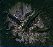
Ilgachuz Range eruptive period
Pliocene
The Pliocene Epoch is the period in the geologic timescale that extends from 5.332 million to 2.588 million years before present. It is the second and youngest epoch of the Neogene Period in the Cenozoic Era. The Pliocene follows the Miocene Epoch and is followed by the Pleistocene Epoch...
Ilgachuz Range
Ilgachuz Range
The Ilgachuz Range is a name given to an extinct shield volcano in British Columbia, Canada. It is not a mountain range in the normal sense, because it was formed as a single volcano that has been eroded for the past 5 million years. It lies on the Chilcotin Plateau, located some north-northwest...
. It is the second youngest of the three large peralkine shield volcanoes that lie on an east-west trend in west-central British Columbia with a diameter of 25 km (16 mi). The Ilgachuz shield was created by two chemically separate magmatic periods; an early complex series of trachyte
Trachyte
Trachyte is an igneous volcanic rock with an aphanitic to porphyritic texture. The mineral assemblage consists of essential alkali feldspar; relatively minor plagioclase and quartz or a feldspathoid such as nepheline may also be present....
and rhyolite
Rhyolite
This page is about a volcanic rock. For the ghost town see Rhyolite, Nevada, and for the satellite system, see Rhyolite/Aquacade.Rhyolite is an igneous, volcanic rock, of felsic composition . It may have any texture from glassy to aphanitic to porphyritic...
eruptions and late extrusion of a sequence of basalt
Basalt
Basalt is a common extrusive volcanic rock. It is usually grey to black and fine-grained due to rapid cooling of lava at the surface of a planet. It may be porphyritic containing larger crystals in a fine matrix, or vesicular, or frothy scoria. Unweathered basalt is black or grey...
ic lava flows. The surface of the outer shield, cut by deeply incised radial valleys, rises to a complexly dissected summit area where remnants of a small central caldera
Caldera
A caldera is a cauldron-like volcanic feature usually formed by the collapse of land following a volcanic eruption, such as the one at Yellowstone National Park in the US. They are sometimes confused with volcanic craters...
and numerous felsic
Felsic
The word "felsic" is a term used in geology to refer to silicate minerals, magma, and rocks which are enriched in the lighter elements such as silicon, oxygen, aluminium, sodium, and potassium....
domes and basalt
Basalt
Basalt is a common extrusive volcanic rock. It is usually grey to black and fine-grained due to rapid cooling of lava at the surface of a planet. It may be porphyritic containing larger crystals in a fine matrix, or vesicular, or frothy scoria. Unweathered basalt is black or grey...
ic feeders are exposed. The outer flanks of the shield merge with flat-lying basalt of the Chilcotin Group, which is thought to have been formed by a back-arc basin
Back-arc basin
Back-arc basins are geologic features, submarine basins associated with island arcs and subduction zones.They are found at some convergent plate boundaries, presently concentrated in the Western Pacific ocean. Most of them result from tensional forces caused by oceanic trench rollback and the...
behind the Cascadia subduction zone
Cascadia subduction zone
The Cascadia subduction zone is a subduction zone, a type of convergent plate boundary that stretches from northern Vancouver Island to northern California. It is a very long sloping fault that separates the Juan de Fuca and North America plates.New ocean floor is being created offshore of...
. The volcano was spewing out ash
Volcanic ash
Volcanic ash consists of small tephra, which are bits of pulverized rock and glass created by volcanic eruptions, less than in diameter. There are three mechanisms of volcanic ash formation: gas release under decompression causing magmatic eruptions; thermal contraction from chilling on contact...
, cinder
Cinder
A cinder is a pyroclastic material. Cinders are extrusive igneous rocks. Cinders are similar to pumice, which has so many cavities and is such low-density that it can float on water...
, pumice
Pumice
Pumice is a textural term for a volcanic rock that is a solidified frothy lava typically created when super-heated, highly pressurized rock is violently ejected from a volcano. It can be formed when lava and water are mixed. This unusual formation is due to the simultaneous actions of rapid...
, rhyolite
Rhyolite
This page is about a volcanic rock. For the ghost town see Rhyolite, Nevada, and for the satellite system, see Rhyolite/Aquacade.Rhyolite is an igneous, volcanic rock, of felsic composition . It may have any texture from glassy to aphanitic to porphyritic...
, trachyte
Trachyte
Trachyte is an igneous volcanic rock with an aphanitic to porphyritic texture. The mineral assemblage consists of essential alkali feldspar; relatively minor plagioclase and quartz or a feldspathoid such as nepheline may also be present....
and basalt
Basalt
Basalt is a common extrusive volcanic rock. It is usually grey to black and fine-grained due to rapid cooling of lava at the surface of a planet. It may be porphyritic containing larger crystals in a fine matrix, or vesicular, or frothy scoria. Unweathered basalt is black or grey...
ic lava up until 4 million years ago.
Itcha Range eruptive period
Trachyte
Trachyte is an igneous volcanic rock with an aphanitic to porphyritic texture. The mineral assemblage consists of essential alkali feldspar; relatively minor plagioclase and quartz or a feldspathoid such as nepheline may also be present....
flows built up the gently sloping Late Pliocene-to-Pleistocene
Pleistocene
The Pleistocene is the epoch from 2,588,000 to 11,700 years BP that spans the world's recent period of repeated glaciations. The name pleistocene is derived from the Greek and ....
Itcha Range
Itcha Range
The Itcha Range is a mountain range on the Chilcotin Plateau of the West-Central Interior of British Columbia, Canada. The range is located 25 miles northeast of Anahim Lake...
. It is the easternmost and youngest of the three large felsic
Felsic
The word "felsic" is a term used in geology to refer to silicate minerals, magma, and rocks which are enriched in the lighter elements such as silicon, oxygen, aluminium, sodium, and potassium....
shield volcanoes lying on an east-west trend in west-central British Columbia. It has a diameter of 15 km (9 mi). The broad scale morphology of the Itcha shield is given by the extensive lateral distribution of thick (70–150 m (230–490 ft)) felsic flows which erupted from fissure vent
Fissure vent
A fissure vent, also known as a volcanic fissure or simply fissure, is a linear volcanic vent through which lava erupts, usually without any explosive activity. The vent is usually a few meters wide and may be many kilometers long. Fissure vents can cause large flood basalts and lava channels...
s around a central vent to cover an area of 330 km³ (79 cu mi). Most late-stage lavas capping the Itcha shield complex were erupted from cinder cone
Cinder cone
According to the , Cinder Cone is the proper name of 1 cinder cone in Canada and 7 cinder cones in the United States:In Canada: Cinder Cone In the United States:...
s, tuff rings, and fissure vent
Fissure vent
A fissure vent, also known as a volcanic fissure or simply fissure, is a linear volcanic vent through which lava erupts, usually without any explosive activity. The vent is usually a few meters wide and may be many kilometers long. Fissure vents can cause large flood basalts and lava channels...
s in the eastern half of the complex about 80,000 years ago.
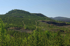
Nazko Cone eruptive period
Holocene
The Holocene is a geological epoch which began at the end of the Pleistocene and continues to the present. The Holocene is part of the Quaternary period. Its name comes from the Greek words and , meaning "entirely recent"...
epoch, the Anahim hotspot has energized numerous volcanoes. This volcanic activity has produced numerous Hawaiian eruption
Hawaiian eruption
A Hawaiian eruption is a type of volcanic eruption where lava flows from the vent in a relative gentle, low level eruption, so called because it is characteristic of Hawaiian volcanoes. Typically they are effusive eruptions, with basaltic magmas of low viscosity, low content of gases, and high...
s, which created lava fountain
Lava fountain
A lava fountain is a volcanic phenomenon in which lava is forcefully but non-explosively ejected from a crater, vent, or fissure. Lava fountains may reach heights of up to . They may occur as a series of short pulses, or a continuous jet of lava. They are commonly seen in Hawaiian eruptions.-See...
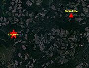
s, small cinder cones and lava flows. The youngest expression of the Anahim hotspot is Nazko Cone
Nazko Cone
Nazko Cone is a small potentially active basaltic cinder cone in central British Columbia, Canada, located 75 km west of Quesnel and 150 kilometers southwest of Prince George. It is considered the easternmost volcano in the Anahim Volcanic Belt. The small tree-covered cone rises 120 m above...
, which formed about 340,000 years ago. The most recent eruptive activity at Nazko Cone occurred about 7,200 years ago. This is very recent in geological terms, suggesting that the volcano may yet have some ongoing volcanic activity. The Rainbow Range is the largest Anahim volcano, although Nazko Cone is now the site of the most intense volcanic activity, located directly on top of the Anahim hotspot at . Its last eruption started with an eruption of two different progressions of runny lava flow
Lava
Lava refers both to molten rock expelled by a volcano during an eruption and the resulting rock after solidification and cooling. This molten rock is formed in the interior of some planets, including Earth, and some of their satellites. When first erupted from a volcanic vent, lava is a liquid at...
s, which resulted in an older, grey basalt becoming overlain by a younger, darker black basaltic lava flow. The passive eruptions were followed by a period of explosive eruption
Explosive eruption
An explosive eruption is a volcanic term to describe a violent, explosive type of eruption. Mount St. Helens in 1980 was an example. Such an eruption is driven by gas accumulating under great pressure. Driven by hot rising magma, it interacts with ground water until the pressure increases to the...
s. This explosive activity built three overlying cinder cones that broke by the two lava flows near the end of the explosive phase of activity. The last phase of explosive activity spread tephra
Tephra
200px|thumb|right|Tephra horizons in south-central [[Iceland]]. The thick and light coloured layer at center of the photo is [[rhyolitic]] tephra from [[Hekla]]....
to the north and east of the cones. The deepest deposits near the cone are less than 3 m (10 ft); that they thin to less than a few centimetres only a few kilometres away, suggests that the explosive eruptions at Nazko Cone were fairly small. However, the last eruption from Nazko Cone could have started forest fire
Wildfire
A wildfire is any uncontrolled fire in combustible vegetation that occurs in the countryside or a wilderness area. Other names such as brush fire, bushfire, forest fire, desert fire, grass fire, hill fire, squirrel fire, vegetation fire, veldfire, and wilkjjofire may be used to describe the same...
s, since there is charcoal
Charcoal
Charcoal is the dark grey residue consisting of carbon, and any remaining ash, obtained by removing water and other volatile constituents from animal and vegetation substances. Charcoal is usually produced by slow pyrolysis, the heating of wood or other substances in the absence of oxygen...
inside the tephra
Tephra
200px|thumb|right|Tephra horizons in south-central [[Iceland]]. The thick and light coloured layer at center of the photo is [[rhyolitic]] tephra from [[Hekla]]....
layer.
Petrology and geochemistry
Continental crust
The continental crust is the layer of igneous, sedimentary, and metamorphic rocks which form the continents and the areas of shallow seabed close to their shores, known as continental shelves. This layer is sometimes called sial due to more felsic, or granitic, bulk composition, which lies in...
, basaltic magma
Magma
Magma is a mixture of molten rock, volatiles and solids that is found beneath the surface of the Earth, and is expected to exist on other terrestrial planets. Besides molten rock, magma may also contain suspended crystals and dissolved gas and sometimes also gas bubbles. Magma often collects in...
is trapped in the less dense continental crust, which is heated and melts to form rhyolite
Rhyolite
This page is about a volcanic rock. For the ghost town see Rhyolite, Nevada, and for the satellite system, see Rhyolite/Aquacade.Rhyolite is an igneous, volcanic rock, of felsic composition . It may have any texture from glassy to aphanitic to porphyritic...
s. These rhyolites can be quite hot and form violent eruptions, despite their low water content. Such rhyolitic magma can be found at the western part of the Anahim Volcanic Belt, which contrasts the more basaltic material in the Nazko Cone area. This suggests that as the North American Plate moves westwards, the Anahim hotspot underlies thinner continental crust
Continental crust
The continental crust is the layer of igneous, sedimentary, and metamorphic rocks which form the continents and the areas of shallow seabed close to their shores, known as continental shelves. This layer is sometimes called sial due to more felsic, or granitic, bulk composition, which lies in...
. This hypothesis has been verified by observation of the crustal regime in other compression margins – the thickest granitic
Granite
Granite is a common and widely occurring type of intrusive, felsic, igneous rock. Granite usually has a medium- to coarse-grained texture. Occasionally some individual crystals are larger than the groundmass, in which case the texture is known as porphyritic. A granitic rock with a porphyritic...
structures are found near the margin itself, with the North American Plate becoming less compressed in regions away from the margin. In this case, the thinner crust would represent briefer travel time, thus reducing the time available for magma differentiation, whose end products are rhyolites. As most magma is basaltic in origin, the eruption would therefore contain more basaltic materials. A few igneous rock
Igneous rock
Igneous rock is one of the three main rock types, the others being sedimentary and metamorphic rock. Igneous rock is formed through the cooling and solidification of magma or lava...
types with composition unlike basalt, such as nephelinite
Nephelinite
Nephelinite is a fine-grained or aphanitic igneous rock made up almost entirely of nepheline and clinopyroxene . If olivine is present, the rock may be classified as an olivine nephelinite. Nephelinite is dark in color and may resemble basalt in hand specimen...
, do occur at the small basaltic cinder cones and flows but are extremely rare.
Basalt
Basalt is a common extrusive volcanic rock. It is usually grey to black and fine-grained due to rapid cooling of lava at the surface of a planet. It may be porphyritic containing larger crystals in a fine matrix, or vesicular, or frothy scoria. Unweathered basalt is black or grey...
ic lava flows have a high ferromagnesian (iron and magnesium) content and erupt at temperatures between 1000°C and 1200°C; these values are higher than those of other common igneous rock
Igneous rock
Igneous rock is one of the three main rock types, the others being sedimentary and metamorphic rock. Igneous rock is formed through the cooling and solidification of magma or lava...
s. Due to the high temperature of this lava flow, the lava would be extremely fluid
Fluid
In physics, a fluid is a substance that continually deforms under an applied shear stress. Fluids are a subset of the phases of matter and include liquids, gases, plasmas and, to some extent, plastic solids....
(it has low viscosity
Viscosity
Viscosity is a measure of the resistance of a fluid which is being deformed by either shear or tensile stress. In everyday terms , viscosity is "thickness" or "internal friction". Thus, water is "thin", having a lower viscosity, while honey is "thick", having a higher viscosity...
), allowing the lava to travel long distances from the magma source (the volcano or vent). These extremely fluid lavas have flow speeds that depend heavily on underlying terrain, with a maximum of almost 60 kilometres per hour (37 mph) in underground lava channel
Lava channel
A lava channel is a stream of fluid lava contained within marginal zones of static lava or levees. The initial channel may not contain levees per se, until the parental flow solidifies over what develops into the channel and creates simple levees. This initial levee allows for the building of a...
s. Flow independent of such channels and tubes moves quite a bit slower, averaging speeds of 1.6 km (0.994196378639691 mi) per hour. However, this flow speed changes considerably within the flow, with speeds depending heavily on depth and degree of cooling that the flow has experienced (essentially distance from the vent). Although the Nazko area flows would not be highly basaltic like those found in Iceland
Iceland
Iceland , described as the Republic of Iceland, is a Nordic and European island country in the North Atlantic Ocean, on the Mid-Atlantic Ridge. Iceland also refers to the main island of the country, which contains almost all the population and almost all the land area. The country has a population...
or Hawaii
Hawaii
Hawaii is the newest of the 50 U.S. states , and is the only U.S. state made up entirely of islands. It is the northernmost island group in Polynesia, occupying most of an archipelago in the central Pacific Ocean, southwest of the continental United States, southeast of Japan, and northeast of...
, lower depths are unlikely as viscosity is normally higher.
A few volcanic centers in the vicinity of the Bella Bella and Gale Passage dike swarms, such as Helmet Peak and Kitasu Hill
Kitasu Hill
Kitasu Hill is a young basaltic cinder cone on southwestern Swindle Island on the coast of the Canadian province of British Columbia. It is located southwest of Klemtu and south of Kitasu Bay. Kitasu Hill produced lava flows that extend to the north...
, which are members of the Milbanke Sound Group
Milbanke Sound Group
The Milbanke Sound Group, also called the Milbanke Sound Cones, is an enigmatic group of five small basaltic volcanoes in the Kitimat Ranges of the Coast Mountains in British Columbia, Canada. Named for Milbanke Sound, this volcanic group straddles on at least four small uninhabited islands,...
, may represent the westernmost of the Anahim volcanoes, but their ages are significantly different, provoking on-going questions about their origin and connection to other regional volcanic activity. However, many volcanoes in that center are believed to be monogenetic
Monogenetic volcanic field
A monogenetic volcanic field is a volcanic field of small, scattered volcanic vents. These volcanic fields, containing numerous monogenetic volcanoes, are noted for having only one short eruptive event at each volcano, as opposed to regular volcanoes that have several eruptions from the same vent...
, suggesting a monogenetic volcanic field
Monogenetic volcanic field
A monogenetic volcanic field is a volcanic field of small, scattered volcanic vents. These volcanic fields, containing numerous monogenetic volcanoes, are noted for having only one short eruptive event at each volcano, as opposed to regular volcanoes that have several eruptions from the same vent...
may be responsible.
Origin
The source of the Anahim hotspot is a matter of controversy. Some geologistGeologist
A geologist is a scientist who studies the solid and liquid matter that constitutes the Earth as well as the processes and history that has shaped it. Geologists usually engage in studying geology. Geologists, studying more of an applied science than a theoretical one, must approach Geology using...
s hypothesize that the Anahim hotspot is linked with an upper mantle plume
Mantle plume
A mantle plume is a hypothetical thermal diapir of abnormally hot rock that nucleates at the core-mantle boundary and rises through the Earth's mantle. Such plumes were invoked in 1971 to explain volcanic regions that were not thought to be explicable by the then-new theory of plate tectonics. Some...
(miniplume
Mantle plume
A mantle plume is a hypothetical thermal diapir of abnormally hot rock that nucleates at the core-mantle boundary and rises through the Earth's mantle. Such plumes were invoked in 1971 to explain volcanic regions that were not thought to be explicable by the then-new theory of plate tectonics. Some...
) rather than the more common deep mantle plume because of the small size of the Bella Bella and Gale Passage dike swarm
Dike swarm
A dike swarm or dyke swarm is a large geological structure consisting of a major group of parallel, linear, or radially oriented dikes intruded within continental crust. They consist of several to hundreds of dikes emplaced more or less contemporaneously during a single intrusive event and are...
s. Others prefer to attribute the hotspot to tensional cracking of the lithosphere
Lithosphere
The lithosphere is the rigid outermost shell of a rocky planet. On Earth, it comprises the crust and the portion of the upper mantle that behaves elastically on time scales of thousands of years or greater.- Earth's lithosphere :...
above the northern edge of the subducting
Subduction
In geology, subduction is the process that takes place at convergent boundaries by which one tectonic plate moves under another tectonic plate, sinking into the Earth's mantle, as the plates converge. These 3D regions of mantle downwellings are known as "Subduction Zones"...
Juan de Fuca
Juan de Fuca Plate
The Juan de Fuca Plate, named after the explorer of the same name, is a tectonic plate, generated from the Juan de Fuca Ridge, and subducting under the northerly portion of the western side of the North American Plate at the Cascadia subduction zone...
and Explorer
Explorer Plate
The Explorer Plate is an oceanic tectonic plate beneath the Pacific Ocean off the west coast of Vancouver Island, Canada.The eastern boundary of the Explorer Plate is being slowly subducted under the North American Plate, to which it may eventually accrete owing to the slow rate of subduction...
plates at the Cascadia subduction zone
Cascadia subduction zone
The Cascadia subduction zone is a subduction zone, a type of convergent plate boundary that stretches from northern Vancouver Island to northern California. It is a very long sloping fault that separates the Juan de Fuca and North America plates.New ocean floor is being created offshore of...
or interpreted as an edge effect of the subducting plates in the mantle
Mantle (geology)
The mantle is a part of a terrestrial planet or other rocky body large enough to have differentiation by density. The interior of the Earth, similar to the other terrestrial planets, is chemically divided into layers. The mantle is a highly viscous layer between the crust and the outer core....
. None of the hypotheses so far suggested is without critics. Part of the controversy is due to the rather sudden appearance of the hotspot in the geologic record. A number of hotspot models have been suggested to explain tensional cracking origins, however. Some of Earth's more prominent hotspots were unified along with flood basalt
Flood basalt
A flood basalt or trap basalt is the result of a giant volcanic eruption or series of eruptions that coats large stretches of land or the ocean floor with basalt lava. Flood basalts have occurred on continental scales in prehistory, creating great plateaus and mountain ranges...
volcanism and continent
Continent
A continent is one of several very large landmasses on Earth. They are generally identified by convention rather than any strict criteria, with seven regions commonly regarded as continents—they are : Asia, Africa, North America, South America, Antarctica, Europe, and Australia.Plate tectonics is...
ial rift
Rift
In geology, a rift or chasm is a place where the Earth's crust and lithosphere are being pulled apart and is an example of extensional tectonics....
ing. While mafic
Mafic
Mafic is an adjective describing a silicate mineral or rock that is rich in magnesium and iron; the term is a portmanteau of the words "magnesium" and "ferric". Most mafic minerals are dark in color and the relative density is greater than 3. Common rock-forming mafic minerals include olivine,...
lava flows appear to merge laterally with the less silicon
Silicon
Silicon is a chemical element with the symbol Si and atomic number 14. A tetravalent metalloid, it is less reactive than its chemical analog carbon, the nonmetal directly above it in the periodic table, but more reactive than germanium, the metalloid directly below it in the table...
-undersaturated lavas of the Chilcotin Group surrounding the Anahim Volcanic Belt
Anahim Volcanic Belt
The Anahim Volcanic Belt is a long volcanic belt, stretching from just north of Vancouver Island to near Quesnel, British Columbia, Canada. The Anahim Volcanic Belt has had three main magmatic episodes: 15–13 Ma, 9–6 Ma, and 3–1 Ma. The volcanoes generally become younger eastward at a rate of to ...
, the particular nature and connection between the Anahim hotspot and the Chilcotin Group is unknown. Volcanic chemistry and isotopic composition of the Anahim Volcanic Belt
Anahim Volcanic Belt
The Anahim Volcanic Belt is a long volcanic belt, stretching from just north of Vancouver Island to near Quesnel, British Columbia, Canada. The Anahim Volcanic Belt has had three main magmatic episodes: 15–13 Ma, 9–6 Ma, and 3–1 Ma. The volcanoes generally become younger eastward at a rate of to ...
do not distinguish between either a rift
Rift
In geology, a rift or chasm is a place where the Earth's crust and lithosphere are being pulled apart and is an example of extensional tectonics....
or a hotspot setting.
Future and present
Anahim Volcanic Belt
The Anahim Volcanic Belt is a long volcanic belt, stretching from just north of Vancouver Island to near Quesnel, British Columbia, Canada. The Anahim Volcanic Belt has had three main magmatic episodes: 15–13 Ma, 9–6 Ma, and 3–1 Ma. The volcanoes generally become younger eastward at a rate of to ...
, but if that is correct, future eruptive activity can be expected in the Nazko Cone
Nazko Cone
Nazko Cone is a small potentially active basaltic cinder cone in central British Columbia, Canada, located 75 km west of Quesnel and 150 kilometers southwest of Prince George. It is considered the easternmost volcano in the Anahim Volcanic Belt. The small tree-covered cone rises 120 m above...
area and east of it. Future eruptions from the Anahim hotspot are most likely in the creation of basalt
Basalt
Basalt is a common extrusive volcanic rock. It is usually grey to black and fine-grained due to rapid cooling of lava at the surface of a planet. It may be porphyritic containing larger crystals in a fine matrix, or vesicular, or frothy scoria. Unweathered basalt is black or grey...
ic cinder cone
Cinder cone
According to the , Cinder Cone is the proper name of 1 cinder cone in Canada and 7 cinder cones in the United States:In Canada: Cinder Cone In the United States:...
s, but eruptions of less mafic
Mafic
Mafic is an adjective describing a silicate mineral or rock that is rich in magnesium and iron; the term is a portmanteau of the words "magnesium" and "ferric". Most mafic minerals are dark in color and the relative density is greater than 3. Common rock-forming mafic minerals include olivine,...
magma, typical of the eastern portions of the Anahim Volcanic Belt, cannot be ruled out.
Seismology
The Anahim hotspot is the only notable earthquake zone in the Canadian CordilleraPacific Cordillera
The Pacific Cordillera is a top-level physiographic region of Canada. This cordillera is part of the Western Cordillera of North America. The mountain ranges in this region were covered during the Pleistocene by the Cordilleran Ice Sheet...
away from the British Columbia Coast
British Columbia Coast
The British Columbia Coast or BC Coast is Canada's western continental coastline on the Pacific Ocean. The usage is synonymous with the term West Coast of Canada....
. A series of <3.0 magnitude earthquakes began October 9, 2007 with its epicenter
Epicenter
The epicenter or epicentre is the point on the Earth's surface that is directly above the hypocenter or focus, the point where an earthquake or underground explosion originates...
in the McNaughton Lake region near Nazko Cone, which could signal the resumption of intense subterranean volcanic activity in the area. Thirty-four such <3.0 magnitude earthquakes were observed on October 10, 2007 alone. Since then more than 1,000 small earthquakes have been recorded. They are thought to have originated 25 km (15.5 mi) below the surface, but none of them have been felt by people. The cause of this seismic activity
Seismology
Seismology is the scientific study of earthquakes and the propagation of elastic waves through the Earth or through other planet-like bodies. The field also includes studies of earthquake effects, such as tsunamis as well as diverse seismic sources such as volcanic, tectonic, oceanic,...
is believed to be the upwelling of 500000 m³ (653,975.3 cu yd) of magma
Magma
Magma is a mixture of molten rock, volatiles and solids that is found beneath the surface of the Earth, and is expected to exist on other terrestrial planets. Besides molten rock, magma may also contain suspended crystals and dissolved gas and sometimes also gas bubbles. Magma often collects in...
, because the area is not close to any faults or tectonic plate
Plate tectonics
Plate tectonics is a scientific theory that describes the large scale motions of Earth's lithosphere...
boundaries. This is the first indication of potential volcanic activity in Canada since around 1830 to 1850 in northwestern British Columbia.
The recent earthquake swarms in the Anahim hotspot have aroused much interest from volcanologist
Volcanology
Volcanology is the study of volcanoes, lava, magma, and related geological, geophysical and geochemical phenomena. The term volcanology is derived from the Latin word vulcan. Vulcan was the ancient Roman god of fire....
s and seismologist
Seismology
Seismology is the scientific study of earthquakes and the propagation of elastic waves through the Earth or through other planet-like bodies. The field also includes studies of earthquake effects, such as tsunamis as well as diverse seismic sources such as volcanic, tectonic, oceanic,...
s since they began on October 9, 2007. More than 1,000 earthquakes have now been detected, and seven stations are now monitoring the area for further activity. The region's earthquake swarms have given rise to speculation of a possible eruption, a possibility estimated around 10%. An eruption in the region would not cause many fatalities, due to the region's remoteness, but people engaged in logging and ranching in the region are at risk. The greatest threats would be from forest fire
Wildfire
A wildfire is any uncontrolled fire in combustible vegetation that occurs in the countryside or a wilderness area. Other names such as brush fire, bushfire, forest fire, desert fire, grass fire, hill fire, squirrel fire, vegetation fire, veldfire, and wilkjjofire may be used to describe the same...
s and possible health risks to those in the area if volcanic gas
Volcanic gas
|250px|thumb|right|Image of the [[rhyolitic]] [[lava dome]] of [[Chaitén Volcano]] during its 2008-2010 eruption.Volcanic gases include a variety of substances given off by active volcanoes...
ses or ash columns
Eruption column
An eruption column consists of hot volcanic ash emitted during an explosive volcanic eruption. The ash forms a column rising many kilometres into the air above the peak of the volcano. In the most explosive eruptions, the eruption column may rise over 40 km, penetrating the stratosphere...
were released. Also, the Anahim hotspot is situated in the immediate proximity of a major air traffic route
Airway
The pulmonary airway comprises those parts of the respiratory system through which air flows, conceptually beginning at the nose and mouth, and terminating in the alveoli...
, and volcanic ash reduces visibility and can cause jet engine failure as well as damage to other aircraft systems.
See also
- Plate tectonicsPlate tectonicsPlate tectonics is a scientific theory that describes the large scale motions of Earth's lithosphere...
- List of volcanoes in Canada
- Anahim Volcanic BeltAnahim Volcanic BeltThe Anahim Volcanic Belt is a long volcanic belt, stretching from just north of Vancouver Island to near Quesnel, British Columbia, Canada. The Anahim Volcanic Belt has had three main magmatic episodes: 15–13 Ma, 9–6 Ma, and 3–1 Ma. The volcanoes generally become younger eastward at a rate of to ...
- Volcanism in CanadaVolcanism in CanadaVolcanism of Canada has produced lava flows, lava plateaus, lava domes, cinder cones, stratovolcanoes, shield volcanoes, submarine volcanoes, calderas, diatremes, and maars, along with examples of more less common volcanic forms such as tuyas and subglacial mounds...
- Coast MountainsCoast MountainsThe Coast Mountains are a major mountain range, in the Pacific Coast Ranges, of western North America, extending from southwestern Yukon through the Alaska Panhandle and virtually all of the Coast of British Columbia. They are so-named because of their proximity to the sea coast, and are often...
- Queen Charlotte BasinQueen Charlotte BasinThe Queen Charlotte Basin is a structural basin mostly beneath the continental shelf offshore, between the Queen Charlotte Islands, Vancouver Island, and the British Columbia mainland, roughly coincident with the physiographic region named the Hecate Depression....
- Geography of British ColumbiaGeography of British ColumbiaBritish Columbia is the westernmost province of Canada, bordered by the Pacific Ocean. With an area of it is Canada's third-largest province. The province is nearly four times the size of Great Britain, two and one-half times larger than Japan and larger than every U.S. state except Alaska. It is...
- Geology of the Pacific NorthwestGeology of the Pacific NorthwestThe geology of the Pacific Northwest refers to the study of the composition , structure, physical properties and the processes that shape the Pacific Northwest region of the United States and Canada...
External links
- Volcanoes of Canada - Map of Canadian volcanoes
- National Resources Canada
- Geology of BC