

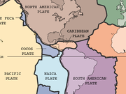
Caribbean Plate
Encyclopedia
Oceanic crust
Oceanic crust is the part of Earth's lithosphere that surfaces in the ocean basins. Oceanic crust is primarily composed of mafic rocks, or sima, which is rich in iron and magnesium...
tectonic plate underlying Central America
Central America
Central America is the central geographic region of the Americas. It is the southernmost, isthmian portion of the North American continent, which connects with South America on the southeast. When considered part of the unified continental model, it is considered a subcontinent...
and the Caribbean Sea
Caribbean Sea
The Caribbean Sea is a sea of the Atlantic Ocean located in the tropics of the Western hemisphere. It is bounded by Mexico and Central America to the west and southwest, to the north by the Greater Antilles, and to the east by the Lesser Antilles....
off the north coast of South America
South America
South America is a continent situated in the Western Hemisphere, mostly in the Southern Hemisphere, with a relatively small portion in the Northern Hemisphere. The continent is also considered a subcontinent of the Americas. It is bordered on the west by the Pacific Ocean and on the north and east...
.
Roughly 3.2 million square kilometers (1.2 million square miles) in area, the Caribbean Plate borders the North American Plate
North American Plate
The North American Plate is a tectonic plate covering most of North America, Greenland, Cuba, Bahamas, and parts of Siberia, Japan and Iceland. It extends eastward to the Mid-Atlantic Ridge and westward to the Chersky Range in eastern Siberia. The plate includes both continental and oceanic crust...
, the South American Plate
South American Plate
The South American Plate is a continental tectonic plate which includes the continent of South America and also a sizeable region of the Atlantic Ocean seabed extending eastward to the Mid-Atlantic Ridge....
, the Nazca Plate
Nazca Plate
]The Nazca Plate, named after the Nazca region of southern Peru, is an oceanic tectonic plate in the eastern Pacific Ocean basin off the west coast of South America. The ongoing subduction along the Peru-Chile Trench of the Nazca Plate under the South American Plate is largely responsible for the...
and the Cocos Plate
Cocos Plate
The Cocos Plate is an oceanic tectonic plate beneath the Pacific Ocean off the west coast of Central America, named for Cocos Island, which rides upon it.-Geology:...
. These borders are regions of intense seismic
Seismology
Seismology is the scientific study of earthquakes and the propagation of elastic waves through the Earth or through other planet-like bodies. The field also includes studies of earthquake effects, such as tsunamis as well as diverse seismic sources such as volcanic, tectonic, oceanic,...
activity, including frequent earthquake
Earthquake
An earthquake is the result of a sudden release of energy in the Earth's crust that creates seismic waves. The seismicity, seismism or seismic activity of an area refers to the frequency, type and size of earthquakes experienced over a period of time...
s, occasional tsunami
Tsunami
A tsunami is a series of water waves caused by the displacement of a large volume of a body of water, typically an ocean or a large lake...
s, and volcanic
Volcano
2. Bedrock3. Conduit 4. Base5. Sill6. Dike7. Layers of ash emitted by the volcano8. Flank| 9. Layers of lava emitted by the volcano10. Throat11. Parasitic cone12. Lava flow13. Vent14. Crater15...
eruptions.
Boundary types
The northern boundary with the North American plate is a transform or strike-slip boundary which runs from the border area of BelizeBelize
Belize is a constitutional monarchy and the northernmost country in Central America. Belize has a diverse society, comprising many cultures and languages. Even though Kriol and Spanish are spoken among the population, Belize is the only country in Central America where English is the official...
, Guatemala
Guatemala
Guatemala is a country in Central America bordered by Mexico to the north and west, the Pacific Ocean to the southwest, Belize to the northeast, the Caribbean to the east, and Honduras and El Salvador to the southeast...
(Motagua Fault
Motagua Fault
The Motagua Fault is a major, active left lateral-moving transform fault which cuts across Guatemala. It forms part of the tectonic boundary between the North American Plate and the Caribbean Plate...
), and Honduras
Honduras
Honduras is a republic in Central America. It was previously known as Spanish Honduras to differentiate it from British Honduras, which became the modern-day state of Belize...
in Central America, eastward through the Cayman trough on south of the southeast coast of Cuba
Cuba
The Republic of Cuba is an island nation in the Caribbean. The nation of Cuba consists of the main island of Cuba, the Isla de la Juventud, and several archipelagos. Havana is the largest city in Cuba and the country's capital. Santiago de Cuba is the second largest city...
, and just north of Hispaniola
Hispaniola
Hispaniola is a major island in the Caribbean, containing the two sovereign states of the Dominican Republic and Haiti. The island is located between the islands of Cuba to the west and Puerto Rico to the east, within the hurricane belt...
, Puerto Rico
Puerto Rico
Puerto Rico , officially the Commonwealth of Puerto Rico , is an unincorporated territory of the United States, located in the northeastern Caribbean, east of the Dominican Republic and west of both the United States Virgin Islands and the British Virgin Islands.Puerto Rico comprises an...
, and the Virgin Islands
Virgin Islands
The Virgin Islands are the western island group of the Leeward Islands, which are the northern part of the Lesser Antilles, which form the border between the Caribbean Sea and the Atlantic Ocean...
. Part of the Puerto Rico Trench
Puerto Rico Trench
The Puerto Rico Trench is an oceanic trench located on the boundary between the Caribbean Sea and the Atlantic Ocean. The trench is associated with a complex transition between the subduction zone to the south along the Lesser Antilles island arc and the major transform fault zone or plate boundary...
, the deepest part of the Atlantic Ocean
Atlantic Ocean
The Atlantic Ocean is the second-largest of the world's oceanic divisions. With a total area of about , it covers approximately 20% of the Earth's surface and about 26% of its water surface area...
(roughly 8,400 meters), lies along this border. The Puerto Rico trench is at a complex transition from the subduction boundary to the south and the transform boundary to the west.
The eastern boundary is a subduction zone, the Lesser Antilles subduction zone
Lesser Antilles subduction zone
The Lesser Antilles subduction zone is a convergent plate boundary on the seafloor along the eastern margin of the Lesser Antilles island arc. In this subduction zone, oceanic crust of the South American Plate is being subducted under the Caribbean Plate....
, where oceanic crust of the South American Plate is being subducted under the Caribbean Plate. Subduction forms the volcanic islands of the Lesser Antilles Volcanic Arc
Lesser Antilles Volcanic Arc
The Lesser Antilles Volcanic Arc is a volcanic arc that forms the eastern boundary of the Caribbean plate. It is part of a subduction zone, also known as the Lesser Antilles subduction zone, where the oceanic crust of the North American Plate is being subducted under the Caribbean Plate...
from the Virgin Islands in the north to the islands off the coast of Venezuela
Venezuela
Venezuela , officially called the Bolivarian Republic of Venezuela , is a tropical country on the northern coast of South America. It borders Colombia to the west, Guyana to the east, and Brazil to the south...
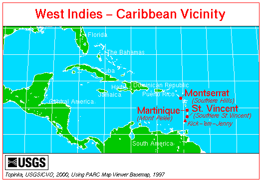
in the south. This boundary contains seventeen active volcanoes, most notably Soufriere Hills on Montserrat
Montserrat
Montserrat is a British overseas territory located in the Leeward Islands, part of the chain of islands called the Lesser Antilles in the West Indies. This island measures approximately long and wide, giving of coastline...
;, Mount Pelée
Mount Pelée
Mount Pelée is an active volcano at the northern end of the island and French overseas department of Martinique in the Lesser Antilles island arc of the Caribbean. Its volcanic cone is composed of layers of volcanic ash and hardened lava....
on Martinique
Martinique
Martinique is an island in the eastern Caribbean Sea, with a land area of . Like Guadeloupe, it is an overseas region of France, consisting of a single overseas department. To the northwest lies Dominica, to the south St Lucia, and to the southeast Barbados...
; La Grande Soufrière
La Grande Soufrière
La Grande Soufrière, , is an active stratovolcano located on the French island of Basse-Terre, in Guadeloupe. It is the tallest mountain in the Lesser Antilles, and rises 1,467 m high....
on Guadeloupe
Guadeloupe
Guadeloupe is an archipelago located in the Leeward Islands, in the Lesser Antilles, with a land area of 1,628 square kilometres and a population of 400,000. It is the first overseas region of France, consisting of a single overseas department. As with the other overseas departments, Guadeloupe...
; Soufrière Saint Vincent
Soufrière (volcano)
La Soufrière [The Sulfurer] or Soufrière Saint Vincent is an active volcano on the island of Saint Vincent in the Windward Islands of the Caribbean.- Geography and structure :...
on Saint Vincent
Saint Vincent (island)
Saint Vincent is a volcanic island in the Caribbean. It is the largest island of the chain called Saint Vincent and the Grenadines. It is located in the Caribbean Sea, between Saint Lucia and Grenada. It is composed of partially submerged volcanic mountains...
; and the submarine volcano Kick-'em-Jenny
Kick-'em-Jenny
Kick-'em-Jenny is an active submarine volcano or seamount on the Caribbean Sea floor, located north of the island of Grenada and about west of Ronde Island in the Grenadines. Kick-'em-Jenny rises above the sea floor on the steep inner western slope of the Lesser Antilles ridge...
which lies about 10 km north of Grenada
Grenada
Grenada is an island country and Commonwealth Realm consisting of the island of Grenada and six smaller islands at the southern end of the Grenadines in the southeastern Caribbean Sea...
.
Along the geologically complex southern boundary, the Caribbean Plate interacts with the South American Plate forming Barbados
Barbados
Barbados is an island country in the Lesser Antilles. It is in length and as much as in width, amounting to . It is situated in the western area of the North Atlantic and 100 kilometres east of the Windward Islands and the Caribbean Sea; therein, it is about east of the islands of Saint...
, Trinidad
Trinidad
Trinidad is the larger and more populous of the two major islands and numerous landforms which make up the island nation of Trinidad and Tobago. It is the southernmost island in the Caribbean and lies just off the northeastern coast of Venezuela. With an area of it is also the fifth largest in...
and Tobago
Tobago
Tobago is the smaller of the two main islands that make up the Republic of Trinidad and Tobago. It is located in the southern Caribbean, northeast of the island of Trinidad and southeast of Grenada. The island lies outside the hurricane belt...
(all on the Caribbean Plate), and islands off the coast of Venezuela (including the Leeward Antilles
Leeward Antilles
The Leeward Antilles are a chain of islands in the Caribbean – specifically, the southerly islands of the Lesser Antilles along the southeastern fringe of the Caribbean Sea, just north of the Venezuelan coast of the South American mainland...
) and Colombia
Colombia
Colombia, officially the Republic of Colombia , is a unitary constitutional republic comprising thirty-two departments. The country is located in northwestern South America, bordered to the east by Venezuela and Brazil; to the south by Ecuador and Peru; to the north by the Caribbean Sea; to the...
. This boundary is in part the result of transform faulting along with thrust fault
Thrust fault
A thrust fault is a type of fault, or break in the Earth's crust across which there has been relative movement, in which rocks of lower stratigraphic position are pushed up and over higher strata. They are often recognized because they place older rocks above younger...
ing and some subduction. The rich Venezuelan petroleum
Petroleum
Petroleum or crude oil is a naturally occurring, flammable liquid consisting of a complex mixture of hydrocarbons of various molecular weights and other liquid organic compounds, that are found in geologic formations beneath the Earth's surface. Petroleum is recovered mostly through oil drilling...
fields possibly result from this complex plate interaction.
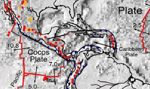
The western portion of the plate is occupied by Central America. The Cocos Plate
Cocos Plate
The Cocos Plate is an oceanic tectonic plate beneath the Pacific Ocean off the west coast of Central America, named for Cocos Island, which rides upon it.-Geology:...
in the Pacific Ocean
Pacific Ocean
The Pacific Ocean is the largest of the Earth's oceanic divisions. It extends from the Arctic in the north to the Southern Ocean in the south, bounded by Asia and Australia in the west, and the Americas in the east.At 165.2 million square kilometres in area, this largest division of the World...
is subducted beneath the Caribbean Plate, just off the western coast of Central America. This subduction forms the volcanoes of Guatemala
Guatemala
Guatemala is a country in Central America bordered by Mexico to the north and west, the Pacific Ocean to the southwest, Belize to the northeast, the Caribbean to the east, and Honduras and El Salvador to the southeast...
, El Salvador
El Salvador
El Salvador or simply Salvador is the smallest and the most densely populated country in Central America. The country's capital city and largest city is San Salvador; Santa Ana and San Miguel are also important cultural and commercial centers in the country and in all of Central America...
, Nicaragua
Nicaragua
Nicaragua is the largest country in the Central American American isthmus, bordered by Honduras to the north and Costa Rica to the south. The country is situated between 11 and 14 degrees north of the Equator in the Northern Hemisphere, which places it entirely within the tropics. The Pacific Ocean...
, and Costa Rica
Costa Rica
Costa Rica , officially the Republic of Costa Rica is a multilingual, multiethnic and multicultural country in Central America, bordered by Nicaragua to the north, Panama to the southeast, the Pacific Ocean to the west and the Caribbean Sea to the east....
, also known as the Central America Volcanic Arc.
Origin
There are two contending theories as to the origin of the Caribbean Plate.One holds that it is a large igneous province
Large igneous province
A Large Igneous Province is an extremely large accumulation of igneous rocks—intrusive, extrusive, or both—in the earth's crust...
that formed in the Pacific Ocean tens of millions of years ago. As the Atlantic Ocean widened, North America and South America were pushed westward, separated for a time by oceanic crust. The Pacific Ocean floor subducted under this oceanic crust between the continents. The Caribbean Plate drifted into the same area, but as it was less dense (although thicker) than the surrounding oceanic crust, it did not subduct, but rather overrode the ocean floor, continuing to move eastward relative to North America and South America. With the formation of the Isthmus of Panama
Isthmus of Panama
The Isthmus of Panama, also historically known as the Isthmus of Darien, is the narrow strip of land that lies between the Caribbean Sea and the Pacific Ocean, linking North and South America. It contains the country of Panama and the Panama Canal...
3 million years ago, it ultimately lost its connection to the Pacific.
A more recent theory asserts that the Caribbean Plate came into being from an Atlantic hotspot which no longer exists. This theory points to evidence of the absolute motion of the Caribbean Plate which indicates that it moves westward, not east, and that its apparent eastward motion is only relative to the motions of the North American Plate
North American Plate
The North American Plate is a tectonic plate covering most of North America, Greenland, Cuba, Bahamas, and parts of Siberia, Japan and Iceland. It extends eastward to the Mid-Atlantic Ridge and westward to the Chersky Range in eastern Siberia. The plate includes both continental and oceanic crust...
and the South American Plate
South American Plate
The South American Plate is a continental tectonic plate which includes the continent of South America and also a sizeable region of the Atlantic Ocean seabed extending eastward to the Mid-Atlantic Ridge....
.
See also
- List of tectonic plates
- Central America Volcanic Arc
- Earthquakes in GuatemalaEarthquakes in GuatemalaEarthquakes are relatively frequent occurrences in Guatemala. The country lies in a major fault zone, known as the Motagua and Chixoy-Polochic fault complex, which cuts across Guatemala and forms the tectonic boundary between the Caribbean plate and the North American plate...
- Gonâve MicroplateGonâve MicroplateThe Gonâve Microplate forms part of the boundary between the North American Plate and the Caribbean Plate. It is bounded to the west by the Cayman spreading center, to the north by the Septentrional-Oriente fault zone and to the south by the Walton fault zone and the Enriquillo-Plantain Garden...
- 2010 Haiti earthquake2010 Haiti earthquakeThe 2010 Haiti earthquake was a catastrophic magnitude 7.0 Mw earthquake, with an epicentre near the town of Léogâne, approximately west of Port-au-Prince, Haiti's capital. The earthquake occurred at 16:53 local time on Tuesday, 12 January 2010.By 24 January, at least 52 aftershocks...