
Nazko Cone
Encyclopedia
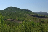
Nazko Cone is a small potentially active basalt
ic cinder cone
in central British Columbia
, Canada
, located 75 km west of Quesnel
and 150 kilometers southwest of Prince George
. It is considered the easternmost volcano in the Anahim Volcanic Belt
. The small tree
-covered cone rises 120 m above the Chilcotin
-Nechako Plateau
and rests on glacial till
. It was formed in three episodes of activity, the first of which took place during the Pleistocene
interglacial stage about 340,000 years ago. The second stage produced a large hyaloclastite
scoria
mound erupted beneath the Cordilleran Ice Sheet
during the Pleistocene. Its last eruption produced two small lava flows that traveled 1 km to the west, along with a blanket of volcanic ash
that extends several km to the north and east of the cone.
 Nazko Cone probably began erupting about 340,000 years ago and has grown steadily since then. Like all of the Anahim volcanoes, Nazko Cone has its origins in the Anahim hotspot
—a plume of magma rising from deep in the Earth's mantle
. The hotspot remains in a fixed position, while the North American Plate
drifts over it at a rate of 2 to 3.3 centimetres per year. The upwelling of the hot magma creates volcanoes, and each individual volcano erupts for a few million years before the movement of the plate carries it away from the rising magma.
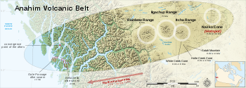
The hotspot has existed for at least 13 million years, and the Anahim Volcanic Belt stretches almost 600 kilometres (400 mi) away from the hotspot. Currently, the hotspot lies under Nazko Cone, which is the youngest volcano in the Anahim Volcanic Belt.
s, an older grey basalt overlain by a younger, darker black basalt. The passive eruptions were followed by a period of explosive eruption
s. This explosive activity built three overlapping cinder cones near the end of the explosive phase of activity. The last phase of explosive activity spread tephra to the north and east of the cones. The deepest deposits near the cones are over 3 m deep and thin to less than a few centimetres only a few kilometres away, which suggests that the explosive eruptions at Nazko Cone were fairly small. However, the last eruption from Nazko Cone could have started forest fire
s, since there is charcoal
inside the tephra
layer.
because the area is not close to any faults or tectonic plate
boundaries.
and ranch
ing in the region, and people engaged in these activities are at risk. Lava flows are likely to flow only a few kilometres from the volcano which could possibly start forest fire
s in the dry region. Ash clouds are likely to affect low flying air traffic since eruptions would likely be in the form of Hawaiian eruption
s - lava fountain
s that create small cinder cone
s and lava flows.
One of the most important tools is seismometry. About 5 seismometer
s were set up around Nazko Cone to enable scientists to measure the intensities and locations of hundreds of small earthquakes every day. Since than, there have been more than 1000 small earthquakes recorded. Earthquakes can begin to increase years before an eruption actually starts.
Another type of seismic activity occurs in the hours preceding an eruption. So-called harmonic tremor
is a continuous "rumble" which contrasts with the normal seismic activity of sudden shocks and is believed to be caused by the rapid movement of magma underground. Volcanic tremor normally indicates an imminent eruption, although it may also be caused by shallow intrusions of magma which do not reach the surface.
Another important indicator of what is happening underground is the shape of the volcano. Tiltmeter
s measure very small changes in the profile of the volcano, and sensitive equipment measures distances between points on the volcano. As magma fills the shallow reservoirs below the summit, the mountain inflates.
its cinder
and scoria
in the early 1990s by the Canadian Pumice Corporation, and has since been steadily reduced to produce red industrial aggregate for landscaping.
Before mining, the Nazko Cone was also a unique ecosystem. The vegetation included a complex of species. Very large old Douglas fir trees were common, growing in some of the more soil-like ash and lava
. White spruce
was surprisingly common, although severely stunted, whereas Lodgepole Pine
was not.
There were some shallow cave
s and hollows below the volcano. To the west, following the lava flow mentioned above, is a unique wetland
which appears to be saturated ash. What makes it unique is the fact that normally wetlands are saturated organic material such as peat moss
. The wetland at Nazko Cone, however, is mixed organic and lava or ash, and the resultant ecosystem is quite unexpected.
Basalt
Basalt is a common extrusive volcanic rock. It is usually grey to black and fine-grained due to rapid cooling of lava at the surface of a planet. It may be porphyritic containing larger crystals in a fine matrix, or vesicular, or frothy scoria. Unweathered basalt is black or grey...
ic cinder cone
Cinder cone
According to the , Cinder Cone is the proper name of 1 cinder cone in Canada and 7 cinder cones in the United States:In Canada: Cinder Cone In the United States:...
in central British Columbia
British Columbia
British Columbia is the westernmost of Canada's provinces and is known for its natural beauty, as reflected in its Latin motto, Splendor sine occasu . Its name was chosen by Queen Victoria in 1858...
, Canada
Canada
Canada is a North American country consisting of ten provinces and three territories. Located in the northern part of the continent, it extends from the Atlantic Ocean in the east to the Pacific Ocean in the west, and northward into the Arctic Ocean...
, located 75 km west of Quesnel
Quesnel, British Columbia
-Demographics:Quesnel had a population of 9,326 people in 2006, which was a decrease of 7.1% from the 2001 census count. The median household income in 2005 for Quesnel was $54,044, which is slightly above the British Columbia provincial average of $52,709....
and 150 kilometers southwest of Prince George
Prince George, British Columbia
Prince George, with a population of 71,030 , is the largest city in northern British Columbia, Canada, and is known as "BC's Northern Capital"...
. It is considered the easternmost volcano in the Anahim Volcanic Belt
Anahim Volcanic Belt
The Anahim Volcanic Belt is a long volcanic belt, stretching from just north of Vancouver Island to near Quesnel, British Columbia, Canada. The Anahim Volcanic Belt has had three main magmatic episodes: 15–13 Ma, 9–6 Ma, and 3–1 Ma. The volcanoes generally become younger eastward at a rate of to ...
. The small tree
Tree
A tree is a perennial woody plant. It is most often defined as a woody plant that has many secondary branches supported clear of the ground on a single main stem or trunk with clear apical dominance. A minimum height specification at maturity is cited by some authors, varying from 3 m to...
-covered cone rises 120 m above the Chilcotin
Chilcotin Plateau
The Chilcotin Plateau is part of the Fraser Plateau, a major subdivision of the Interior Plateau of British Columbia. The Chilcotin Plateau is physically near-identical with the region of the same name, i.e...
-Nechako Plateau
Nechako Plateau
The Nechako Plateau is the northernmost subdivision of the Interior Plateau, one of the main geographic regions of the Canadian province of British Columbia...
and rests on glacial till
Till
thumb|right|Closeup of glacial till. Note that the larger grains in the till are completely surrounded by the matrix of finer material , and this characteristic, known as matrix support, is diagnostic of till....
. It was formed in three episodes of activity, the first of which took place during the Pleistocene
Pleistocene
The Pleistocene is the epoch from 2,588,000 to 11,700 years BP that spans the world's recent period of repeated glaciations. The name pleistocene is derived from the Greek and ....
interglacial stage about 340,000 years ago. The second stage produced a large hyaloclastite
Hyaloclastite
Hyaloclastite is a hydrated tuff-like breccia rich in black volcanic glass, formed during volcanic eruptions under water, under ice or where subaerial flows reach the sea or other bodies of water. It has the appearance of angular flat fragments sized between a millimeter to few centimeters...
scoria
Scoria
Scoria is a volcanic rock containing many holes or vesicles. It is most generally dark in color , and basaltic or andesitic in composition. Scoria is relatively low in mass as a result of its numerous macroscopic ellipsoidal vesicles, but in contrast to pumice, all scoria has a specific gravity...
mound erupted beneath the Cordilleran Ice Sheet
Cordilleran Ice Sheet
The Cordilleran ice sheet was a major ice sheet that covered, during glacial periods of the Quaternary, a large area of North America. This included the following areas:*Western Montana*The Idaho Panhandle...
during the Pleistocene. Its last eruption produced two small lava flows that traveled 1 km to the west, along with a blanket of volcanic ash
Volcanic ash
Volcanic ash consists of small tephra, which are bits of pulverized rock and glass created by volcanic eruptions, less than in diameter. There are three mechanisms of volcanic ash formation: gas release under decompression causing magmatic eruptions; thermal contraction from chilling on contact...
that extends several km to the north and east of the cone.
Origins
Anahim hotspot
The Anahim hotspot is a volcanic hotspot in central British Columbia, Canada. It is situated on the Interior Plateau, a large region that lies between the Cariboo and Monashee Mountains to the east, and the Hazelton Mountains, Coast Mountains and Cascade Range to the west...
—a plume of magma rising from deep in the Earth's mantle
Mantle (geology)
The mantle is a part of a terrestrial planet or other rocky body large enough to have differentiation by density. The interior of the Earth, similar to the other terrestrial planets, is chemically divided into layers. The mantle is a highly viscous layer between the crust and the outer core....
. The hotspot remains in a fixed position, while the North American Plate
North American Plate
The North American Plate is a tectonic plate covering most of North America, Greenland, Cuba, Bahamas, and parts of Siberia, Japan and Iceland. It extends eastward to the Mid-Atlantic Ridge and westward to the Chersky Range in eastern Siberia. The plate includes both continental and oceanic crust...
drifts over it at a rate of 2 to 3.3 centimetres per year. The upwelling of the hot magma creates volcanoes, and each individual volcano erupts for a few million years before the movement of the plate carries it away from the rising magma.
The hotspot has existed for at least 13 million years, and the Anahim Volcanic Belt stretches almost 600 kilometres (400 mi) away from the hotspot. Currently, the hotspot lies under Nazko Cone, which is the youngest volcano in the Anahim Volcanic Belt.
7200 BP Eruption of Nazko Cone
The eruptive cycle of Nazko Cone 7200 years ago started with the eruption of two different progressions of fluid lava flowLava
Lava refers both to molten rock expelled by a volcano during an eruption and the resulting rock after solidification and cooling. This molten rock is formed in the interior of some planets, including Earth, and some of their satellites. When first erupted from a volcanic vent, lava is a liquid at...
s, an older grey basalt overlain by a younger, darker black basalt. The passive eruptions were followed by a period of explosive eruption
Explosive eruption
An explosive eruption is a volcanic term to describe a violent, explosive type of eruption. Mount St. Helens in 1980 was an example. Such an eruption is driven by gas accumulating under great pressure. Driven by hot rising magma, it interacts with ground water until the pressure increases to the...
s. This explosive activity built three overlapping cinder cones near the end of the explosive phase of activity. The last phase of explosive activity spread tephra to the north and east of the cones. The deepest deposits near the cones are over 3 m deep and thin to less than a few centimetres only a few kilometres away, which suggests that the explosive eruptions at Nazko Cone were fairly small. However, the last eruption from Nazko Cone could have started forest fire
Wildfire
A wildfire is any uncontrolled fire in combustible vegetation that occurs in the countryside or a wilderness area. Other names such as brush fire, bushfire, forest fire, desert fire, grass fire, hill fire, squirrel fire, vegetation fire, veldfire, and wilkjjofire may be used to describe the same...
s, since there is charcoal
Charcoal
Charcoal is the dark grey residue consisting of carbon, and any remaining ash, obtained by removing water and other volatile constituents from animal and vegetation substances. Charcoal is usually produced by slow pyrolysis, the heating of wood or other substances in the absence of oxygen...
inside the tephra
Tephra
200px|thumb|right|Tephra horizons in south-central [[Iceland]]. The thick and light coloured layer at center of the photo is [[rhyolitic]] tephra from [[Hekla]]....
layer.
Recent activity
The volcano has been dormant since the 7200 BP eruption. On October 10, 2007, a small swarm of earthquakes appeared 20 kilometres west of Nazko Cone. Most of these earthquakes were magnitude 1.0 or less; some as strong as M 3.1 or 3.2 were centered 25 kilometres below the surface. The cause of this seismic activity is believed to be the upwelling of magmaMagma
Magma is a mixture of molten rock, volatiles and solids that is found beneath the surface of the Earth, and is expected to exist on other terrestrial planets. Besides molten rock, magma may also contain suspended crystals and dissolved gas and sometimes also gas bubbles. Magma often collects in...
because the area is not close to any faults or tectonic plate
Plate tectonics
Plate tectonics is a scientific theory that describes the large scale motions of Earth's lithosphere...
boundaries.
Hazards
Future eruptions from Nazko Cone are unlikely to cause many fatalities, due to the region's remoteness. There is active loggingLogging
Logging is the cutting, skidding, on-site processing, and loading of trees or logs onto trucks.In forestry, the term logging is sometimes used in a narrow sense concerning the logistics of moving wood from the stump to somewhere outside the forest, usually a sawmill or a lumber yard...
and ranch
Ranch
A ranch is an area of landscape, including various structures, given primarily to the practice of ranching, the practice of raising grazing livestock such as cattle or sheep for meat or wool. The word most often applies to livestock-raising operations in the western United States and Canada, though...
ing in the region, and people engaged in these activities are at risk. Lava flows are likely to flow only a few kilometres from the volcano which could possibly start forest fire
Wildfire
A wildfire is any uncontrolled fire in combustible vegetation that occurs in the countryside or a wilderness area. Other names such as brush fire, bushfire, forest fire, desert fire, grass fire, hill fire, squirrel fire, vegetation fire, veldfire, and wilkjjofire may be used to describe the same...
s in the dry region. Ash clouds are likely to affect low flying air traffic since eruptions would likely be in the form of Hawaiian eruption
Hawaiian eruption
A Hawaiian eruption is a type of volcanic eruption where lava flows from the vent in a relative gentle, low level eruption, so called because it is characteristic of Hawaiian volcanoes. Typically they are effusive eruptions, with basaltic magmas of low viscosity, low content of gases, and high...
s - lava fountain
Lava fountain
A lava fountain is a volcanic phenomenon in which lava is forcefully but non-explosively ejected from a crater, vent, or fissure. Lava fountains may reach heights of up to . They may occur as a series of short pulses, or a continuous jet of lava. They are commonly seen in Hawaiian eruptions.-See...
s that create small cinder cone
Cinder cone
According to the , Cinder Cone is the proper name of 1 cinder cone in Canada and 7 cinder cones in the United States:In Canada: Cinder Cone In the United States:...
s and lava flows.
Monitoring
Nazko Cone has been an intensively monitored volcano by the Geological Survey of Canada since October 10, 2007.One of the most important tools is seismometry. About 5 seismometer
Seismometer
Seismometers are instruments that measure motions of the ground, including those of seismic waves generated by earthquakes, volcanic eruptions, and other seismic sources...
s were set up around Nazko Cone to enable scientists to measure the intensities and locations of hundreds of small earthquakes every day. Since than, there have been more than 1000 small earthquakes recorded. Earthquakes can begin to increase years before an eruption actually starts.
Another type of seismic activity occurs in the hours preceding an eruption. So-called harmonic tremor
Harmonic tremor
Harmonic tremor describes a long-duration release of seismic energy, with distinct spectral lines, that often precedes or accompanies a volcanic eruption...
is a continuous "rumble" which contrasts with the normal seismic activity of sudden shocks and is believed to be caused by the rapid movement of magma underground. Volcanic tremor normally indicates an imminent eruption, although it may also be caused by shallow intrusions of magma which do not reach the surface.
Another important indicator of what is happening underground is the shape of the volcano. Tiltmeter
Tiltmeter
A tiltmeter is an instrument designed to measure very small changes from the horizontal level, either on the ground or in structures. A similar term, in less common usage, is the inclinometer...
s measure very small changes in the profile of the volcano, and sensitive equipment measures distances between points on the volcano. As magma fills the shallow reservoirs below the summit, the mountain inflates.
Recent history
Nazko Cone was staked for miningMining
Mining is the extraction of valuable minerals or other geological materials from the earth, from an ore body, vein or seam. The term also includes the removal of soil. Materials recovered by mining include base metals, precious metals, iron, uranium, coal, diamonds, limestone, oil shale, rock...
its cinder
Cinder
A cinder is a pyroclastic material. Cinders are extrusive igneous rocks. Cinders are similar to pumice, which has so many cavities and is such low-density that it can float on water...
and scoria
Scoria
Scoria is a volcanic rock containing many holes or vesicles. It is most generally dark in color , and basaltic or andesitic in composition. Scoria is relatively low in mass as a result of its numerous macroscopic ellipsoidal vesicles, but in contrast to pumice, all scoria has a specific gravity...
in the early 1990s by the Canadian Pumice Corporation, and has since been steadily reduced to produce red industrial aggregate for landscaping.
Before mining, the Nazko Cone was also a unique ecosystem. The vegetation included a complex of species. Very large old Douglas fir trees were common, growing in some of the more soil-like ash and lava
Lava
Lava refers both to molten rock expelled by a volcano during an eruption and the resulting rock after solidification and cooling. This molten rock is formed in the interior of some planets, including Earth, and some of their satellites. When first erupted from a volcanic vent, lava is a liquid at...
. White spruce
White Spruce
Picea glauca is a species of spruce native to boreal forests in the north of North America, from central Alaska east to Newfoundland, and south to northern Montana, Minnesota, Wisconsin, Michigan, upstate New York, Vermont, New Hampshire, and Maine; there is also an isolated population in the...
was surprisingly common, although severely stunted, whereas Lodgepole Pine
Lodgepole Pine
Lodgepole Pine, Pinus contorta, also known as Shore Pine, is a common tree in western North America. Like all pines, it is evergreen.-Subspecies:...
was not.
There were some shallow cave
Cave
A cave or cavern is a natural underground space large enough for a human to enter. The term applies to natural cavities some part of which is in total darkness. The word cave also includes smaller spaces like rock shelters, sea caves, and grottos.Speleology is the science of exploration and study...
s and hollows below the volcano. To the west, following the lava flow mentioned above, is a unique wetland
Wetland
A wetland is an area of land whose soil is saturated with water either permanently or seasonally. Wetlands are categorised by their characteristic vegetation, which is adapted to these unique soil conditions....
which appears to be saturated ash. What makes it unique is the fact that normally wetlands are saturated organic material such as peat moss
Sphagnum
Sphagnum is a genus of between 151 and 350 species of mosses commonly called peat moss, due to its prevalence in peat bogs and mires. A distinction is made between sphagnum moss, the live moss growing on top of a peat bog on one hand, and sphagnum peat moss or sphagnum peat on the other, the...
. The wetland at Nazko Cone, however, is mixed organic and lava or ash, and the resultant ecosystem is quite unexpected.
See also
- Anahim Volcanic BeltAnahim Volcanic BeltThe Anahim Volcanic Belt is a long volcanic belt, stretching from just north of Vancouver Island to near Quesnel, British Columbia, Canada. The Anahim Volcanic Belt has had three main magmatic episodes: 15–13 Ma, 9–6 Ma, and 3–1 Ma. The volcanoes generally become younger eastward at a rate of to ...
- List of volcanoes in Canada
- Anahim hotspotAnahim hotspotThe Anahim hotspot is a volcanic hotspot in central British Columbia, Canada. It is situated on the Interior Plateau, a large region that lies between the Cariboo and Monashee Mountains to the east, and the Hazelton Mountains, Coast Mountains and Cascade Range to the west...
- Volcanism of Canada
- Volcanism of Western CanadaVolcanism of Western CanadaVolcanism of Western Canada produces lava flows, lava plateaus, lava domes, cinder cones, stratovolcanoes, shield volcanoes, submarine volcanoes, calderas, diatremes and maars, along with examples of more less common volcanic forms such as tuyas and subglacial mounds.-Volcanic belts:*Anahim...
- Itcha RangeItcha RangeThe Itcha Range is a mountain range on the Chilcotin Plateau of the West-Central Interior of British Columbia, Canada. The range is located 25 miles northeast of Anahim Lake...
- Ilgachuz RangeIlgachuz RangeThe Ilgachuz Range is a name given to an extinct shield volcano in British Columbia, Canada. It is not a mountain range in the normal sense, because it was formed as a single volcano that has been eroded for the past 5 million years. It lies on the Chilcotin Plateau, located some north-northwest...
- Rainbow RangeRainbow Range (Coast Mountains)The Rainbow Range, formerly known as the Rainbow Mountains, is a mountain range in British Columbia, Canada, located northwest of Anahim Lake...