
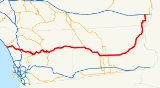
California State Route 78
Encyclopedia
State Route 78 is a state highway
in the U.S. state
of California
in the United States
(U.S.) that runs from Oceanside
east to Blythe
, traversing nearly the entire width of the state. Its western terminus is at Interstate 5 (I-5) in San Diego County
and its eastern terminus is at I-10 in Riverside County
. The route is a freeway through the heavily populated cities of northern San Diego County and a two-lane highway running through the Santa Rosa Mountains
to Julian
. In Imperial County
SR 78 travels through the desert near the Salton Sea
and passes through the city of Brawley
before turning north and passing through an area of sand dunes on the way to its terminus in Blythe.
SR 78 was one of the original state highways designated in 1934, although portions of the route existed as early as 1900. However, it was not designated east of Brawley
until 1959. The freeway section in the North County of San Diego that connects Oceanside and Escondido
was built in the middle of the twentieth century in several stages, including a transitory stage known as the Vista Way Freeway, and has been improved several times. There are many projects slated to improve the freeway due to increasing congestion in that region. An expressway bypass of the city of Brawley is also under construction.
to I-15
in the city of Escondido
, and Ben Hulse Highway (after a former state senator named Ben Hulse) from SR 86 near Brawley to I-10 near the city of Blythe
. The portion of SR 78 from SR 86 in Brawley to County Route S3 (CR S3) near Anza-Borrego Desert State Park
is designated as part of the Juan Bautista de Anza National Historic Trail
auto tour route, promoted by the National Park Service
. SR 78 is part of the California Freeway and Expressway System
, although only the metropolitan section of SR 78 is a freeway. The section of SR 78 from the western junction of SR 79 to the western junction with SR 86 is designated by the California State Legislature
as eligible by law for the State Scenic Highway System
; however, only the section in Anza Borrego Desert State Park has officially been designated by Caltrans as being part of the system.
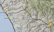
State Route 78 begins in Oceanside as a continuation of Vista Way. As it encounters a traffic signal and crosses over I-5, the route becomes a suburban freeway traveling east through Oceanside. The freeway loosely parallels Buena Vista Creek before entering the city of Vista
. The freeway then turns southeast, continuing into the city of San Marcos
near California State University San Marcos and entering Escondido, where it has an interchange with I-15. After passing the Center City Parkway (I-15 Business) interchange, the freeway abruptly ends at the intersection with Broadway. SR 78 then makes a turn south onto Broadway and continues through downtown Escondido by turning east onto Washington Avenue and south onto Ash Street, which becomes San Pasqual Valley Road.
Turning east once again, SR 78 leaves the Escondido city limits and enters the San Pasqual Valley as it provides access to the San Diego Zoo Safari Park and San Pasqual Battlefield State Park
. After leaving the San Pasqual Valley, the road follows a serpentine alignment, heading south to enter the community of Ramona
as Pine Street. In Ramona, SR 78 intersects SR 67 and makes a turn east onto Main Street, going through downtown Ramona. The highway leaves Ramona as Julian Road, which continues on a winding mountain alignment through Witch Creek to Santa Ysabel
where it meets State Route 79.
SR 78 runs concurrently with SR 79 across the headwaters of the San Diego River
and through the hamlet of Wynola, briefly entering Cleveland National Forest
before reaching Julian
as Washington Street. SR 78, still concurrent with SR 79, turns east onto Main Street and travels through downtown Julian before SR 79 diverges south towards Cuyamaca
and SR 78 heads northeast as Banner Road. The road intersects with County Route S2 (CR S2) in what is known as Scissors Crossing; CR S2 runs concurrently in a wrong-way concurrency. Shortly afterwards, SR 78 enters Anza-Borrego Desert State Park and is designated as a scenic highway for its length in the state park. Although this route travels many miles south of the town of Borrego Springs
, it provides access to the town via CR S3. SR 78 travels through the town of Ocotillo Wells
before exiting the state park and entering Imperial County
.
In Imperial County, State Route 78 intersects with State Route 86, running concurrently with it southwest of the Salton Sea
and northwest of San Felipe Creek. SR 78 passes through the desert community of Elmore Desert Ranch
before entering the city of Westmorland
. SR 78, still concurrent with SR 86, enters into the city of Brawley
as Main Street, where SR 86 splits off to the south towards El Centro
. After going through downtown for several blocks, the highway intersects with SR 111 and runs concurrently with it for about a mile, where SR 111 turns south again. SR 78 then intersects with SR 115 east of Brawley, running concurrently with it as well for a brief distance. Shortly after passing through the small community of Glamis
, the road turns northeast and eventually north towards Blythe, passing near the Chocolate Mountain Naval Reserve
. As it nears the Colorado River
and the Arizona
border, SR 78 briefly passes through Cibola National Wildlife Refuge
before entering the community of Palo Verde
, where the river turns away from the highway and SR 78 enters Riverside County
.
As it nears Blythe, the highway makes a sharp turn east onto 32nd Avenue before turning north on Rannels Boulevard. It makes a right on 28th Avenue before turning north on Washington Boulevard and passing through Ripley
. SR 78 continues north for a few more miles to its terminus at I-10 a few miles west of Blythe.
No road connected Brawley with Glamis at this time; it was necessary to travel north through Calipatria
to reach Blythe. East of the Sand Hills, there was a road from Glamis passing by Smith Well into Palo Verde, which roughly follows the routing of SR 78. Around the 1930s, the road from Escondido to Ramona was a gravel road, and the portion from Julian to U.S. Route 99
(US 99), which is currently designated as SR 86, was a dirt road.
SR 78 was originally formed along with the originally signed state highways in California (Sign Routes) in 1934; however, it only extended to what was then US 99 near Kane Springs. In the North County, SR 78 was legislatively designated as Legislative Route 196 from then-US 101 (present-day I-5) to Vista, and as Legislative Route 77 from Vista to U.S. Route 395 in Escondido. SR 78 was legally known as Legislative Route 197 from Escondido to Ramona, and Legislative Route 198 from Ramona to US 99, which is now SR 86. From US 99 in Brawley to SR 115, SR 78 was defined as Legislative Route 187.
 During the 1940s, US 395 ran concurrently along the portion of SR 78 from Vista to Escondido before continuing along Santa Fe Avenue to Bonsall and Fallbrook and rejoining its alignment during the 1970s. At this time, all of SR 78 that existed had been paved.
Before the present-day freeway was built, SR 78 was routed on the Vista Way Freeway (which was an expressway) from Oceanside east to downtown Vista. After this, it followed Santa Fe Avenue and Mission Road east (now signed as CR S14), continuing onto Grand Avenue in Escondido. After intersecting US 395, SR 78 turned south on Ash Street and rejoined the current alignment of the highway.
The Vista Way Freeway opened in April 1962 between I-5 and Melrose Drive, but was not entirely grade-separated. The first section of the SR 78 freeway from San Marcos to west of Vista was completed in early 1963, at a cost of $3.9 million (about $ today). The rest of the freeway between San Marcos and Escondido was constructed between 1963 and 1968. The section from I-5 east to Melrose Drive (along the routing of the Vista Way Freeway) had been upgraded to full freeway standards as of 1973. The College Boulevard diamond interchange
on this western segment opened to traffic on October 24, 1967, and functioned to connect the recently opened MiraCosta College
to the freeway. The interchange, previously an at-grade intersection
, improved traffic flow to the college. The construction of the interchange cost $800,941 at the time (about $ today).
The missing portions of the current SR 78 routing in Imperial County were constructed after 1963, when the state legislature allowed for a road to be built from SR 115 to the Riverside County line. This portion of the road was specifically designed to address the challenges of building it through sand dunes. The engineers routed the highway according to the terrain and made cuts in the sand up to eighty feet deep. In 1957, the United States Navy
obtained ownership from Imperial County of the road running through the Chocolate Mountain Aerial Gunnery Range for $660 thousand (about $ today). This money was used to fund the construction of what would become SR 78, which Ben Hulse (who later had the highway named after him) predicted would become a state highway. Following this, in 1965, the newly constructed section was signed as Imperial County Route S78. Legislatively, it was designated as Legislative Route 146 from the Riverside county line into Blythe, and eventually was signed as SR 195 from Palo Verde into Blythe; the SR 195 and Legislative Route 146 designations continued along the path of current US 95
to the Nevada state line. In 1959, the rest of the current routing of SR 78 between Brawley and Palo Verde was added to the state highway system as SR 195 and Legislative Route 146. The section from Palo Verde to Blythe shows up as part of SR 78 on maps as early as 1965, and the section from southwest of Midway Well to Palo Verde is shown as part of SR 78 as early as 1966.
In 1969, plans to extend the freeway portion of SR 78 east from the Broadway interchange through Escondido were delayed by Caltrans director Jacob Dekema due to a lack of funding; however, these plans fell through, as the bypass does not exist today. Finally, in 1971, the entire routing of SR 78 as it is today began to appear on highway maps.
lot. The interchange at Nordahl Road will also be improved.
In the Imperial and Riverside County portion from Brawley to Blythe, the road goes through several washes
. During the monsoon
season, these washes can be left with several inches of water, sand, and rock debris following rainstorms. There is a proposal to improve drainage by raising the roadway and installing culvert
s.
There are plans to build a bypass around the downtown portion of the city of Brawley. An expressway would carry the routing of SR 78 north and east of the city, with an interchange at SR 111, before intersecting with the current alignment of SR 78. A Swedish company began construction on this bypass in April 2008; the second phase of the bypass was projected to take until late 2010 to complete. However, on the third phase of the project, construction only began in late 2010 and is expected to take until early 2013 to be finished. This project was identified in August 2010 as a project that could be affected by California state budget cuts.
|colspan=4 align=center|West end of freeway
|-
|colspan=4 align=center|East end of freeway
State highway
State highway, state road or state route can refer to one of three related concepts, two of them related to a state or provincial government in a country that is divided into states or provinces :#A...
in the U.S. state
U.S. state
A U.S. state is any one of the 50 federated states of the United States of America that share sovereignty with the federal government. Because of this shared sovereignty, an American is a citizen both of the federal entity and of his or her state of domicile. Four states use the official title of...
of California
California
California is a state located on the West Coast of the United States. It is by far the most populous U.S. state, and the third-largest by land area...
in the United States
United States
The United States of America is a federal constitutional republic comprising fifty states and a federal district...
(U.S.) that runs from Oceanside
Oceanside, California
-2010:The 2010 United States Census reported that Oceanside had a population of 167,086. The population density was 3,961.8 people per square mile...
east to Blythe
Blythe, California
Blythe is a city in Riverside County, California, United States, in the "Palo Verde Valley" of the Lower Colorado River Valley region, an agricultural area and part of the Colorado Desert along the Colorado River. Blythe was named after Thomas Blythe, a gold prospector who established primary...
, traversing nearly the entire width of the state. Its western terminus is at Interstate 5 (I-5) in San Diego County
San Diego County, California
San Diego County is a large county located in the southwestern corner of the US state of California. Hence, San Diego County is also located in the southwestern corner of the 48 contiguous United States. Its county seat and largest city is San Diego. Its population was about 2,813,835 in the 2000...
and its eastern terminus is at I-10 in Riverside County
Riverside County, California
Riverside County is a county in the U.S. state of California. One of 58 California counties, it covers in the southern part of the state, and stretches from Orange County to the Colorado River, which forms the state border with Arizona. The county derives its name from the city of Riverside,...
. The route is a freeway through the heavily populated cities of northern San Diego County and a two-lane highway running through the Santa Rosa Mountains
Santa Rosa Mountains (California)
The Santa Rosa Mountains are a short mountain range in the Peninsular Ranges system, located east of the Los Angeles Basin and northeast of the San Diego metropolitan area of southern California, in the Southwestern United States.-Geography:...
to Julian
Julian, California
Julian is a census-designated place in San Diego County, California, in the United States. As of the 2010 census, the population was 1,502, down from 1,621 at the 2000 census.Julian is an official California Historical Landmark No. 412...
. In Imperial County
Imperial County, California
Imperial County is a county located in the Imperial Valley, in the far southeast of the U.S. state of California, bordering both Arizona and Mexico. It is part of the El Centro Metropolitan Area, which encompasses all of Imperial County. The population as of 2000 was 142,361. The county seat is the...
SR 78 travels through the desert near the Salton Sea
Salton Sea
The Salton Sea is a shallow, saline, endorheic rift lake located directly on the San Andreas Fault, predominantly in California's Imperial Valley. The lake occupies the lowest elevations of the Salton Sink in the Colorado Desert of Imperial and Riverside counties in Southern California. Like Death...
and passes through the city of Brawley
Brawley, California
Brawley is a city in Imperial County, California, United States. Brawley is located north of El Centro. The population was 24,953 at the 2010 census, up from 22,052 at the 2000 census. The town has a significant cattle and feed industry, and hosts the annual Cattle Call Rodeo. Year-round...
before turning north and passing through an area of sand dunes on the way to its terminus in Blythe.
SR 78 was one of the original state highways designated in 1934, although portions of the route existed as early as 1900. However, it was not designated east of Brawley
Brawley, California
Brawley is a city in Imperial County, California, United States. Brawley is located north of El Centro. The population was 24,953 at the 2010 census, up from 22,052 at the 2000 census. The town has a significant cattle and feed industry, and hosts the annual Cattle Call Rodeo. Year-round...
until 1959. The freeway section in the North County of San Diego that connects Oceanside and Escondido
Escondido, California
Escondido is a city occupying a shallow valley ringed by rocky hills, just north of the city of San Diego, California. Founded in 1888, it is one of the oldest cities in San Diego County. The city had a population of 143,911 at the 2010 census. Its municipal government set itself an operating...
was built in the middle of the twentieth century in several stages, including a transitory stage known as the Vista Way Freeway, and has been improved several times. There are many projects slated to improve the freeway due to increasing congestion in that region. An expressway bypass of the city of Brawley is also under construction.
Route description
State Route 78 is designated as Ronald Packard Parkway (after a former Congressman named Ronald Packard from the area) from I-5 in the city of OceansideOceanside, California
-2010:The 2010 United States Census reported that Oceanside had a population of 167,086. The population density was 3,961.8 people per square mile...
to I-15
Interstate 15 in California
In the U.S. state of California, Interstate 15 is a major north–south route through the San Bernardino, Riverside, and San Diego Counties, and it has a length of in the state. It is a major thoroughfare for traffic between Southern California and Las Vegas, Nevada, as well as points beyond...
in the city of Escondido
Escondido, California
Escondido is a city occupying a shallow valley ringed by rocky hills, just north of the city of San Diego, California. Founded in 1888, it is one of the oldest cities in San Diego County. The city had a population of 143,911 at the 2010 census. Its municipal government set itself an operating...
, and Ben Hulse Highway (after a former state senator named Ben Hulse) from SR 86 near Brawley to I-10 near the city of Blythe
Blythe, California
Blythe is a city in Riverside County, California, United States, in the "Palo Verde Valley" of the Lower Colorado River Valley region, an agricultural area and part of the Colorado Desert along the Colorado River. Blythe was named after Thomas Blythe, a gold prospector who established primary...
. The portion of SR 78 from SR 86 in Brawley to County Route S3 (CR S3) near Anza-Borrego Desert State Park
Anza-Borrego Desert State Park
Anza-Borrego Desert State Park is a state park located within the Colorado Desert of Southern California. The park takes its name from 18th century, Spanish explorer Juan Bautista de Anza and borrego, the Spanish word for bighorn sheep...
is designated as part of the Juan Bautista de Anza National Historic Trail
Juan Bautista de Anza National Historic Trail
thumb|325px|MAP: [[Juan Bautista de Anza]] National Historic Trail routes in [[Arizona]] and [[California]].The Juan Bautista de Anza National Historic Trail is a National Park Service unit in the United States National Historic Trail and National Millennium Trail programs...
auto tour route, promoted by the National Park Service
National Park Service
The National Park Service is the U.S. federal agency that manages all national parks, many national monuments, and other conservation and historical properties with various title designations...
. SR 78 is part of the California Freeway and Expressway System
California Freeway and Expressway System
The California Freeway and Expressway System is a system of existing or planned freeways and expressways in the U.S. state of California. It is defined by the Streets and Highways Code.-List of roads in the system:*State Route 1 *State Route 2...
, although only the metropolitan section of SR 78 is a freeway. The section of SR 78 from the western junction of SR 79 to the western junction with SR 86 is designated by the California State Legislature
California State Legislature
The California State Legislature is the state legislature of the U.S. state of California. It is a bicameral body consisting of the lower house, the California State Assembly, with 80 members, and the upper house, the California State Senate, with 40 members...
as eligible by law for the State Scenic Highway System
State Scenic Highway System (California)
The State Scenic Highway System is a list of highways, mainly state highways, that have been designated by the California Department of Transportation as scenic highways. The California State Legislature, primarily through Section 263 of the Streets and Highways Code, makes highways eligible for...
; however, only the section in Anza Borrego Desert State Park has officially been designated by Caltrans as being part of the system.
State Route 78 begins in Oceanside as a continuation of Vista Way. As it encounters a traffic signal and crosses over I-5, the route becomes a suburban freeway traveling east through Oceanside. The freeway loosely parallels Buena Vista Creek before entering the city of Vista
Vista, California
Vista is a city in north San Diego County, California. It was incorporated January 28, 1963 and became a charter city on June 13, 2007. Located just seven miles inland from the Pacific Ocean in northern San Diego County, the City of Vista has a Mediterranean climate...
. The freeway then turns southeast, continuing into the city of San Marcos
San Marcos, California
San Marcos is a suburb of San Diego in the North County section of San Diego County, California. As of the 2010 census, the city had a total population of 83,781. Outside the San Diego region, it is best known as the home of California State University, San Marcos...
near California State University San Marcos and entering Escondido, where it has an interchange with I-15. After passing the Center City Parkway (I-15 Business) interchange, the freeway abruptly ends at the intersection with Broadway. SR 78 then makes a turn south onto Broadway and continues through downtown Escondido by turning east onto Washington Avenue and south onto Ash Street, which becomes San Pasqual Valley Road.
Turning east once again, SR 78 leaves the Escondido city limits and enters the San Pasqual Valley as it provides access to the San Diego Zoo Safari Park and San Pasqual Battlefield State Park
Battle of San Pasqual
The Battle of San Pasqual, also spelled San Pascual, was a military encounter that occurred during the Mexican-American War in what is now the San Pasqual Valley community of the city of San Diego, California. On December 6 and December 7, 1846, General Stephen W...
. After leaving the San Pasqual Valley, the road follows a serpentine alignment, heading south to enter the community of Ramona
Ramona, California
Ramona is a census-designated place in San Diego County, California. The population was 20,292 at the 2010 census.The term Ramona also refers to an unincorporated community that includes both the Ramona CDP and the adjacent CDP of San Diego Country Estates CDP...
as Pine Street. In Ramona, SR 78 intersects SR 67 and makes a turn east onto Main Street, going through downtown Ramona. The highway leaves Ramona as Julian Road, which continues on a winding mountain alignment through Witch Creek to Santa Ysabel
Santa Ysabel, California
Santa Ysabel is an unincorporated community in California, in the east half of San Diego County. It is home to Santa Ysabel Asistencia, a Spanish mission...
where it meets State Route 79.
SR 78 runs concurrently with SR 79 across the headwaters of the San Diego River
San Diego River
The San Diego River is a river in San Diego County, California. It originates in the Cuyamaca Mountains northwest of the town of Julian, then flows to the southwest until it reaches the El Capitan Reservoir, the largest reservoir in the river's watershed at . Below El Capitan Dam, the river runs...
and through the hamlet of Wynola, briefly entering Cleveland National Forest
Cleveland National Forest
Cleveland National Forest encompasses 460,000 acres , mostly of chaparral, with a few riparian areas. A warm dry mediterranean climate prevails over the Forest. It is the southernmost National forest of California. It is administered by the United States Forest Service, a government agency within...
before reaching Julian
Julian, California
Julian is a census-designated place in San Diego County, California, in the United States. As of the 2010 census, the population was 1,502, down from 1,621 at the 2000 census.Julian is an official California Historical Landmark No. 412...
as Washington Street. SR 78, still concurrent with SR 79, turns east onto Main Street and travels through downtown Julian before SR 79 diverges south towards Cuyamaca
Cuyamaca, California
Cuyamaca is a region of eastern San Diego County. It lies east of the Capitan Grande Indian Reservation in the western Laguna Mountains, north of Descanso and south of Julian. Named for the 1845 Rancho Cuyamaca Mexican land grant, the region is now dominated by the Cuyamaca Rancho State Park...
and SR 78 heads northeast as Banner Road. The road intersects with County Route S2 (CR S2) in what is known as Scissors Crossing; CR S2 runs concurrently in a wrong-way concurrency. Shortly afterwards, SR 78 enters Anza-Borrego Desert State Park and is designated as a scenic highway for its length in the state park. Although this route travels many miles south of the town of Borrego Springs
Borrego Springs, California
Borrego Springs is a census-designated place in San Diego County, California. The population was 3,429 at the 2010 census, up from 2,535 at the 2000 census. Many residents are seasonal while others remain year round...
, it provides access to the town via CR S3. SR 78 travels through the town of Ocotillo Wells
Ocotillo Wells, California
Ocotillo Wells is an unincorporated community in San Diego County, California. It is west of the Imperial County line on State Route 78 at an elevation of . The name became official in 1962 when it was adopted for federal use by the Board of Geographic Names. A federally-recognized variant name,...
before exiting the state park and entering Imperial County
Imperial County, California
Imperial County is a county located in the Imperial Valley, in the far southeast of the U.S. state of California, bordering both Arizona and Mexico. It is part of the El Centro Metropolitan Area, which encompasses all of Imperial County. The population as of 2000 was 142,361. The county seat is the...
.
In Imperial County, State Route 78 intersects with State Route 86, running concurrently with it southwest of the Salton Sea
Salton Sea
The Salton Sea is a shallow, saline, endorheic rift lake located directly on the San Andreas Fault, predominantly in California's Imperial Valley. The lake occupies the lowest elevations of the Salton Sink in the Colorado Desert of Imperial and Riverside counties in Southern California. Like Death...
and northwest of San Felipe Creek. SR 78 passes through the desert community of Elmore Desert Ranch
Elmore Desert Ranch, California
Elmore Desert Ranch is an unincorporated community in Imperial County, California. It lies at an elevation of 177 feet below sea level....
before entering the city of Westmorland
Westmorland, California
Westmorland is a city in Imperial County, California. Westmorland is located southwest of Calipatria, The population was 2,225 at the 2010 census, up from 2,131 at the 2000 census...
. SR 78, still concurrent with SR 86, enters into the city of Brawley
Brawley, California
Brawley is a city in Imperial County, California, United States. Brawley is located north of El Centro. The population was 24,953 at the 2010 census, up from 22,052 at the 2000 census. The town has a significant cattle and feed industry, and hosts the annual Cattle Call Rodeo. Year-round...
as Main Street, where SR 86 splits off to the south towards El Centro
El Centro, California
El Centro is a city in and county seat of Imperial County, the largest city in the Imperial Valley and the east anchor of the Southern California Border Region, and the core urban area and principal city of the El Centro metropolitan area which encompasses all of Imperial County. El Centro is also...
. After going through downtown for several blocks, the highway intersects with SR 111 and runs concurrently with it for about a mile, where SR 111 turns south again. SR 78 then intersects with SR 115 east of Brawley, running concurrently with it as well for a brief distance. Shortly after passing through the small community of Glamis
Glamis, California
Glamis is an unincorporated community in Imperial County, California. It is located northeast of Holtville, at an elevation of 335 feet ....
, the road turns northeast and eventually north towards Blythe, passing near the Chocolate Mountain Naval Reserve
Chocolate Mountain Aerial Gunnery Range
The Chocolate Mountain Aerial Gunnery Range , is a 456,000 acre restricted area, approximately 20 miles wide, east to west, and 50 miles long, northwest to southeast, which is used by the Navy and Marines for aerial bombing and live fire aerial gunnery practice...
. As it nears the Colorado River
Colorado River
The Colorado River , is a river in the Southwestern United States and northwestern Mexico, approximately long, draining a part of the arid regions on the western slope of the Rocky Mountains. The watershed of the Colorado River covers in parts of seven U.S. states and two Mexican states...
and the Arizona
Arizona
Arizona ; is a state located in the southwestern region of the United States. It is also part of the western United States and the mountain west. The capital and largest city is Phoenix...
border, SR 78 briefly passes through Cibola National Wildlife Refuge
Cibola National Wildlife Refuge
Cibola National Wildlife Refuge is a U.S. National Wildlife Refuge in the floodplain of the lower Colorado River between Arizona and California and surrounded by a fringe of desert ridges and washes. The refuge encompasses both the historic Colorado River channel as well as a channelized portion...
before entering the community of Palo Verde
Palo Verde, California
Palo Verde is a census-designated place in Imperial County, California. Palo Verde is located on the Riverside County line northeast of El Centro, The population was 171 at the 2010 census, down from 236 at the 2000 census. It is part of the 'El Centro, California Metropolitan Statistical Area'...
, where the river turns away from the highway and SR 78 enters Riverside County
Riverside County, California
Riverside County is a county in the U.S. state of California. One of 58 California counties, it covers in the southern part of the state, and stretches from Orange County to the Colorado River, which forms the state border with Arizona. The county derives its name from the city of Riverside,...
.
As it nears Blythe, the highway makes a sharp turn east onto 32nd Avenue before turning north on Rannels Boulevard. It makes a right on 28th Avenue before turning north on Washington Boulevard and passing through Ripley
Ripley, California
Ripley is a census-designated place community in east Riverside County. It is located along State Route 78 between Palo Verde and Blythe. The area is mostly agricultural lands irrigated by Colorado River water. The elevation is...
. SR 78 continues north for a few more miles to its terminus at I-10 a few miles west of Blythe.
Before construction
Before the designation of SR 78, a road known as the Brawley-Westmorland-Julian-Oceanside Highway (connecting Oceanside, Escondido, Ramona, Julian, Westmorland, and Brawley) existed during the early twentieth century. This road roughly followed the current routing of SR 78 from Escondido to the east of Brawley, although it traveled along a different routing from Westmorland into Brawley.No road connected Brawley with Glamis at this time; it was necessary to travel north through Calipatria
Calipatria, California
Calipatria is a city in Imperial County, California. Calipatria is located north of El Centro, It is part of the El Centro Metropolitan Area. The population was 7,705 at the 2010 census, up from 7,289 at the 2000 census, including 4000 inmates at Calipatria State Prison...
to reach Blythe. East of the Sand Hills, there was a road from Glamis passing by Smith Well into Palo Verde, which roughly follows the routing of SR 78. Around the 1930s, the road from Escondido to Ramona was a gravel road, and the portion from Julian to U.S. Route 99
U.S. Route 99
U.S. Route 99 was the main north–south highway on the West Coast of the United States until 1964, running from Calexico, California, on the U.S.-Mexico border to Blaine, Washington, on the U.S.-Canada border. It was a route of the United States Numbered Highways, assigned in 1926 and existing...
(US 99), which is currently designated as SR 86, was a dirt road.
SR 78 was originally formed along with the originally signed state highways in California (Sign Routes) in 1934; however, it only extended to what was then US 99 near Kane Springs. In the North County, SR 78 was legislatively designated as Legislative Route 196 from then-US 101 (present-day I-5) to Vista, and as Legislative Route 77 from Vista to U.S. Route 395 in Escondido. SR 78 was legally known as Legislative Route 197 from Escondido to Ramona, and Legislative Route 198 from Ramona to US 99, which is now SR 86. From US 99 in Brawley to SR 115, SR 78 was defined as Legislative Route 187.
Construction
Before the present-day freeway was built, SR 78 was routed on the Vista Way Freeway (which was an expressway) from Oceanside east to downtown Vista. After this, it followed Santa Fe Avenue and Mission Road east (now signed as CR S14), continuing onto Grand Avenue in Escondido. After intersecting US 395, SR 78 turned south on Ash Street and rejoined the current alignment of the highway.
The Vista Way Freeway opened in April 1962 between I-5 and Melrose Drive, but was not entirely grade-separated. The first section of the SR 78 freeway from San Marcos to west of Vista was completed in early 1963, at a cost of $3.9 million (about $ today). The rest of the freeway between San Marcos and Escondido was constructed between 1963 and 1968. The section from I-5 east to Melrose Drive (along the routing of the Vista Way Freeway) had been upgraded to full freeway standards as of 1973. The College Boulevard diamond interchange
Diamond interchange
A diamond interchange is a common type of road junction, used where a freeway crosses a minor road. The freeway itself is grade-separated from the minor road, one crossing the other over a bridge...
on this western segment opened to traffic on October 24, 1967, and functioned to connect the recently opened MiraCosta College
MiraCosta College
MiraCosta College is a community college located in the northern coastal region of San Diego County, California. MiraCosta College is located at 1 Barnard Drive, Oceanside, California 92056. It also has a campus in Cardiff-by-the-Sea and a Community Learning Center in Oceanside.- History :MiraCosta...
to the freeway. The interchange, previously an at-grade intersection
At-grade intersection
An at-grade intersection is a junction at which two or more transport axes cross at the same level .-Traffic management:With areas of high or fast traffic, an at-grade intersection normally requires a traffic control device such as a stop sign, traffic light or railway signal to manage conflicting...
, improved traffic flow to the college. The construction of the interchange cost $800,941 at the time (about $ today).
The missing portions of the current SR 78 routing in Imperial County were constructed after 1963, when the state legislature allowed for a road to be built from SR 115 to the Riverside County line. This portion of the road was specifically designed to address the challenges of building it through sand dunes. The engineers routed the highway according to the terrain and made cuts in the sand up to eighty feet deep. In 1957, the United States Navy
United States Navy
The United States Navy is the naval warfare service branch of the United States Armed Forces and one of the seven uniformed services of the United States. The U.S. Navy is the largest in the world; its battle fleet tonnage is greater than that of the next 13 largest navies combined. The U.S...
obtained ownership from Imperial County of the road running through the Chocolate Mountain Aerial Gunnery Range for $660 thousand (about $ today). This money was used to fund the construction of what would become SR 78, which Ben Hulse (who later had the highway named after him) predicted would become a state highway. Following this, in 1965, the newly constructed section was signed as Imperial County Route S78. Legislatively, it was designated as Legislative Route 146 from the Riverside county line into Blythe, and eventually was signed as SR 195 from Palo Verde into Blythe; the SR 195 and Legislative Route 146 designations continued along the path of current US 95
U.S. Route 95 in California
In the U.S. state of California, U.S. Route 95 traverses through the far eastern edges of both Riverside and San Bernardino counties. US 95 serves Blythe and Needles and junctions with SR 62 at Vidal Junction....
to the Nevada state line. In 1959, the rest of the current routing of SR 78 between Brawley and Palo Verde was added to the state highway system as SR 195 and Legislative Route 146. The section from Palo Verde to Blythe shows up as part of SR 78 on maps as early as 1965, and the section from southwest of Midway Well to Palo Verde is shown as part of SR 78 as early as 1966.
In 1969, plans to extend the freeway portion of SR 78 east from the Broadway interchange through Escondido were delayed by Caltrans director Jacob Dekema due to a lack of funding; however, these plans fell through, as the bypass does not exist today. Finally, in 1971, the entire routing of SR 78 as it is today began to appear on highway maps.
Following initial construction
During the last decade, several significant improvements have been made to SR 78 in the North County. A new interchange with Vista Village Drive was opened in 1998, and the College Boulevard interchange in Oceanside was revised along westbound SR 78. In addition to this, a new interchange was constructed at Las Posas Road in San Marcos, which opened in 2006.Future
The western portion of SR 78 in North County is currently slated for several improvements. There were plans to construct an additional interchange at Rancho Del Oro Road in Oceanside; however, the Oceanside City Council decided to cancel these plans in 2005, despite studies suggesting that this would be detrimental to the traffic in the region. There are also plans to improve the interchange with I-5, which currently involves a traffic signal connecting Vista Way and SR 78 with the ramps to I-5 southbound. Plans call for adding more lanes to I-5 and SR 78 as well as for the construction of a new ramp from SR 78 westbound to I-5 southbound and from I-5 southbound to SR 78 eastbound. In the past, there was a direct ramp from SR 78 westbound to I-5 southbound which avoided this traffic signal; however, it was removed to construct a park and ridePark and ride
Park and ride facilities are car parks with connections to public transport that allow commuters and other people wishing to travel into city centres to leave their vehicles and transfer to a bus, rail system , or carpool for the rest of their trip...
lot. The interchange at Nordahl Road will also be improved.
In the Imperial and Riverside County portion from Brawley to Blythe, the road goes through several washes
Arroyo (creek)
An arroyo , a Spanish word translated as brook, and also called a wash is usually a dry creek or stream bed—gulch that temporarily or seasonally fills and flows after sufficient rain. Wadi is a similar term in Africa. In Spain, a rambla has a similar meaning to arroyo.-Types and processes:Arroyos...
. During the monsoon
Monsoon
Monsoon is traditionally defined as a seasonal reversing wind accompanied by corresponding changes in precipitation, but is now used to describe seasonal changes in atmospheric circulation and precipitation associated with the asymmetric heating of land and sea...
season, these washes can be left with several inches of water, sand, and rock debris following rainstorms. There is a proposal to improve drainage by raising the roadway and installing culvert
Culvert
A culvert is a device used to channel water. It may be used to allow water to pass underneath a road, railway, or embankment. Culverts can be made of many different materials; steel, polyvinyl chloride and concrete are the most common...
s.
There are plans to build a bypass around the downtown portion of the city of Brawley. An expressway would carry the routing of SR 78 north and east of the city, with an interchange at SR 111, before intersecting with the current alignment of SR 78. A Swedish company began construction on this bypass in April 2008; the second phase of the bypass was projected to take until late 2010 to complete. However, on the third phase of the project, construction only began in late 2010 and is expected to take until early 2013 to be finished. This project was identified in August 2010 as a project that could be affected by California state budget cuts.
Major intersections
|-|colspan=4 align=center|West end of freeway
|-
|colspan=4 align=center|East end of freeway