

Imperial Valley
Encyclopedia
Southern California
Southern California is a megaregion, or megapolitan area, in the southern area of the U.S. state of California. Large urban areas include Greater Los Angeles and Greater San Diego. The urban area stretches along the coast from Ventura through the Southland and Inland Empire to San Diego...
's Imperial County
Imperial County, California
Imperial County is a county located in the Imperial Valley, in the far southeast of the U.S. state of California, bordering both Arizona and Mexico. It is part of the El Centro Metropolitan Area, which encompasses all of Imperial County. The population as of 2000 was 142,361. The county seat is the...
. It is located in southeastern Southern California
Southern California
Southern California is a megaregion, or megapolitan area, in the southern area of the U.S. state of California. Large urban areas include Greater Los Angeles and Greater San Diego. The urban area stretches along the coast from Ventura through the Southland and Inland Empire to San Diego...
, centered around the city of El Centro. Locally, the terms "Imperial Valley" and "Imperial County" are used synonymously. The Valley is bordered between the Colorado River
Colorado River
The Colorado River , is a river in the Southwestern United States and northwestern Mexico, approximately long, draining a part of the arid regions on the western slope of the Rocky Mountains. The watershed of the Colorado River covers in parts of seven U.S. states and two Mexican states...
to the east and, in part, the Salton Sea
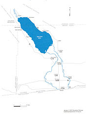
Salton Sea
The Salton Sea is a shallow, saline, endorheic rift lake located directly on the San Andreas Fault, predominantly in California's Imperial Valley. The lake occupies the lowest elevations of the Salton Sink in the Colorado Desert of Imperial and Riverside counties in Southern California. Like Death...
to the west. Farther west lies the San Diego and Imperial County border. To the north is the Inland Empire's Coachella Valley
Coachella Valley
Coachella Valley is a large valley landform in Southern California. The valley extends for approximately 45 miles in Riverside County southeast from the San Bernardino Mountains to the saltwater Salton Sea, the largest lake in California...
, which together form the "Cahuilla Basin" or the "Salton Trough", also the county line of Imperial and Riverside counties, and to the south the international boundary with the U.S. state of California and Baja California
Baja California
Baja California officially Estado Libre y Soberano de Baja California is one of the 31 states which, with the Federal District, comprise the 32 Federal Entities of Mexico. It is both the northernmost and westernmost state of Mexico. Before becoming a state in 1953, the area was known as the North...
.
The Imperial Valley is rich in natural beauty, local history, and culture. The unique culture of the area blends the two different countries of the United States
United States
The United States of America is a federal constitutional republic comprising fifty states and a federal district...
with Mexico
Mexico
The United Mexican States , commonly known as Mexico , is a federal constitutional republic in North America. It is bordered on the north by the United States; on the south and west by the Pacific Ocean; on the southeast by Guatemala, Belize, and the Caribbean Sea; and on the east by the Gulf of...
, due to its regional history and geographic location along the international border. This creates a small town atmosphere, and an economy based on agriculture, and a strong work ethic for the people of the valley. From early in January through the winter holiday season, the Imperial Valley hosts many festivals and activities that keep things moving. From the aerial displays of the Blue Angels to the Tomato Festival. From the North to the South. Imperial Valley offers visitors and residents a taste of many cultures such as those from Mexico
Mexico
The United Mexican States , commonly known as Mexico , is a federal constitutional republic in North America. It is bordered on the north by the United States; on the south and west by the Pacific Ocean; on the southeast by Guatemala, Belize, and the Caribbean Sea; and on the east by the Gulf of...
with all its sights, sounds and tastes waiting to be savored. Mexico can easily be accessed by vehicle or by walking due to the Valleys proximity to the border.
Imperial Valley was so named by the Imperial Land Company
Imperial Land Company
The Imperial Land Company was a land colonization company incorporated in California in March, 1900 for the purpose of encouraging settlement of the Imperial Valley thus providing customers for the California Development Company...
, in hopes of attracting settlers. Having done that it is now the home of the El Centro metropolitan area and also an economic center of California's, government defined, "South Border".
Geography

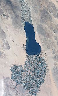
Salton Sea
The Salton Sea is a shallow, saline, endorheic rift lake located directly on the San Andreas Fault, predominantly in California's Imperial Valley. The lake occupies the lowest elevations of the Salton Sink in the Colorado Desert of Imperial and Riverside counties in Southern California. Like Death...
into Mexico
Mexico
The United Mexican States , commonly known as Mexico , is a federal constitutional republic in North America. It is bordered on the north by the United States; on the south and west by the Pacific Ocean; on the southeast by Guatemala, Belize, and the Caribbean Sea; and on the east by the Gulf of...
. Part of a trough stretching from the Coachella Valley to the Gulf of California
Gulf of California
The Gulf of California is a body of water that separates the Baja California Peninsula from the Mexican mainland...
, it is almost entirely below sea level—235 feet (72 m) below at the edge of the Salton Sea. Its hot desert climate is characterized by daily temperature extremes. It was once part of the Gulf of California
Gulf of California
The Gulf of California is a body of water that separates the Baja California Peninsula from the Mexican mainland...
, from which it was cut off by the dam-like deposits of the Colorado River
Colorado River
The Colorado River , is a river in the Southwestern United States and northwestern Mexico, approximately long, draining a part of the arid regions on the western slope of the Rocky Mountains. The watershed of the Colorado River covers in parts of seven U.S. states and two Mexican states...
Delta Fan as it carved out the Grand Canyon
Grand Canyon
The Grand Canyon is a steep-sided canyon carved by the Colorado River in the United States in the state of Arizona. It is largely contained within the Grand Canyon National Park, the 15th national park in the United States...
. Bordered by sand dunes and barren mountains, it was uninhabited until 1901, when the Imperial Canal
Alamo Canal
The Alamo Canal was a long waterway that connected the Colorado River to the head of the Alamo River. The canal was constructed to provide irrigation to the Imperial Valley. A small portion of the canal was located in the United States but the majority of the canal was located in Mexico...
was opened and diverted Colorado River water into the valley through Mexico. Floodwaters in 1905–07 destroyed the irrigation channels and created the Salton Sea now filled by the New River
New River (Mexico – United States)
The New River flows north from near Cerro Prieto, through the city of Mexicali, Baja California, Mexico, into the United States through the city of Calexico, California towards the Salton Sea...
and irrigation run-off. The rivers in the southern part of the Salton Sea river basin flow south to north.
The valley is bordered by the Colorado River
Colorado River
The Colorado River , is a river in the Southwestern United States and northwestern Mexico, approximately long, draining a part of the arid regions on the western slope of the Rocky Mountains. The watershed of the Colorado River covers in parts of seven U.S. states and two Mexican states...
to the east and, in part, the Salton Sea
Salton Sea
The Salton Sea is a shallow, saline, endorheic rift lake located directly on the San Andreas Fault, predominantly in California's Imperial Valley. The lake occupies the lowest elevations of the Salton Sink in the Colorado Desert of Imperial and Riverside counties in Southern California. Like Death...
to the west. Farther west lies the border with San Diego County
San Diego County, California
San Diego County is a large county located in the southwestern corner of the US state of California. Hence, San Diego County is also located in the southwestern corner of the 48 contiguous United States. Its county seat and largest city is San Diego. Its population was about 2,813,835 in the 2000...
, and to the south the international boundary between the U.S. state of California
California
California is a state located on the West Coast of the United States. It is by far the most populous U.S. state, and the third-largest by land area...
and Baja California
Baja California
Baja California officially Estado Libre y Soberano de Baja California is one of the 31 states which, with the Federal District, comprise the 32 Federal Entities of Mexico. It is both the northernmost and westernmost state of Mexico. Before becoming a state in 1953, the area was known as the North...
, Mexico
Mexico
The United Mexican States , commonly known as Mexico , is a federal constitutional republic in North America. It is bordered on the north by the United States; on the south and west by the Pacific Ocean; on the southeast by Guatemala, Belize, and the Caribbean Sea; and on the east by the Gulf of...
. To the north is the boundary with the Inland Empire
Inland Empire (California)
The Inland Empire is a region in Southern California. The region sits directly east of the Los Angeles metropolitan area. The Inland Empire most commonly is used in reference to the U.S. Census Bureau's federally-defined Riverside-San Bernardino-Ontario metropolitan area, which covers more than...
's Riverside County
Riverside County, California
Riverside County is a county in the U.S. state of California. One of 58 California counties, it covers in the southern part of the state, and stretches from Orange County to the Colorado River, which forms the state border with Arizona. The county derives its name from the city of Riverside,...
and its Coachella Valley
Coachella Valley
Coachella Valley is a large valley landform in Southern California. The valley extends for approximately 45 miles in Riverside County southeast from the San Bernardino Mountains to the saltwater Salton Sea, the largest lake in California...
, which with the Imperial Valley form the "Cahuilla Basin" or the "Salton Trough
Salton Sink
The Salton Sink is a geographic sink in the Coachella and Imperial valleys of southeastern California. It is in the Colorado Desert subregion of the Sonoran Desert ecoregion...
".
Climate
The Imperial Valley often has summer temperatures well over 100 degrees, but from late October until mid-April the temperature is relatively mild and can sometimes even reach low temperatures not expected in a desert. During winter months the Valley averages more than eight hours of sunshine a day, receiving the most sunlight of any place in the United StatesUnited States
The United States of America is a federal constitutional republic comprising fifty states and a federal district...
.
Historically, the lowest minimum temperature ever recorded in the Imperial Valley was 16 degrees F on January 22, 1937. The highest maximum temperature ever recorded was 121 degrees F on July 28, 1995. The lowest maximum temperature was 42 degrees F, recorded on January 24, 1949, and the highest minimum temperature was 92 degrees F on June 30, 1946. The highest monthly mean temperature was 95.9 degrees F, recorded in August 1969 and the lowest mean temperature was 42.3 degrees F in February 1939.
The 85-year average annual rainfall is 2.93 inches (74.4 mm) with June being the driest month. The only recorded snowfall in the Valley occurred on December 12, 1932. Snow began falling at 8:45 p.m. and by 5 a.m. The next day 2.5 inches (6.4 cm) had been recorded. In the southwest portion of Imperial Valley, 4 inches (10.2 cm) of snow was reported that day. This was the only snowfall of record to cover the entire valley.
Population
The El Centro Metropolitan Area is home to 163,972 residents, according to a 2008 US Census estimate and encompasses the whole Imperial County. The area is in the far southeast region of the State of California. Major population centers are BrawleyBrawley, California
Brawley is a city in Imperial County, California, United States. Brawley is located north of El Centro. The population was 24,953 at the 2010 census, up from 22,052 at the 2000 census. The town has a significant cattle and feed industry, and hosts the annual Cattle Call Rodeo. Year-round...
, Calexico
Calexico, California
Calexico is a city in Imperial County, California. The population was 38,572 at the 2010 census, up from 27,109 at the 2000 census. Calexico is about east of San Diego and west of Yuma, Arizona...
and El Centro
El Centro, California
El Centro is a city in and county seat of Imperial County, the largest city in the Imperial Valley and the east anchor of the Southern California Border Region, and the core urban area and principal city of the El Centro metropolitan area which encompasses all of Imperial County. El Centro is also...
which is the county seat
County seat
A county seat is an administrative center, or seat of government, for a county or civil parish. The term is primarily used in the United States....
. Imperial Valley is one of the fastest growing counties in the State of California offering many business opportunities along with a large number of trade possibilities.
Imperial County had the largest percentage increase in population in California between 2008 and 2009 in the state, according to the California Department of Finance
California Department of Finance
The California Department of Finance is a state cabinet-level agency within the government of California. The Department of Finance is responsible for preparing, explaining, and administering the state’s annual financial plan, which the Governor of California is required under the California...
. The county had a population growth rate of 2.2 percent between July 1, 2008, and July 1, 2009. The county’s growth rate has consistently been one of the top 10 out of 58 counties in California
California
California is a state located on the West Coast of the United States. It is by far the most populous U.S. state, and the third-largest by land area...
for the past six years. Last year’s growth rate was 2.43 percent.
El Centro
El Centro, California
El Centro is a city in and county seat of Imperial County, the largest city in the Imperial Valley and the east anchor of the Southern California Border Region, and the core urban area and principal city of the El Centro metropolitan area which encompasses all of Imperial County. El Centro is also...
is the promising new major commercial and industrial center of Southern California for the imperial valley, being the center of shipping exports as well as being home to retail, transportation, wholesale, and agricultural industries. There are also two international border crossings nearby for commercial and noncommercial vehicles. The city's population was 37,835 at the 2000 census. The 2006 population is 40,563. The city is 50 feet (15.2 m) below sea level and the largest city in the United States below sea level. Fifty percent of the jobs in El Centro come from the service and retail sector.
Regions
Imperial Valley can loosely categorize its cities and communities into three regions: the Salton Beach Towns, Desert Cities, and the El Centro area (urbanized Imperial). The Salton Sea Beach Towns have the smallest cities but were resorts in their heyday and have since shrunk in population and size due to the current state of the Salton Sea. The cities and communities of the desert region are outliers in that they are away from urbanized Imperial and tend to be smaller in population then the cities surrounding El Centro. Cities of the El Centro area tend to be larger than those of the desert and Salton regions.Cities over 10,000 population

- El CentroEl Centro, CaliforniaEl Centro is a city in and county seat of Imperial County, the largest city in the Imperial Valley and the east anchor of the Southern California Border Region, and the core urban area and principal city of the El Centro metropolitan area which encompasses all of Imperial County. El Centro is also...
(County SeatCounty seatA county seat is an administrative center, or seat of government, for a county or civil parish. The term is primarily used in the United States....
) - CalexicoCalexico, CaliforniaCalexico is a city in Imperial County, California. The population was 38,572 at the 2010 census, up from 27,109 at the 2000 census. Calexico is about east of San Diego and west of Yuma, Arizona...
- BrawleyBrawley, CaliforniaBrawley is a city in Imperial County, California, United States. Brawley is located north of El Centro. The population was 24,953 at the 2010 census, up from 22,052 at the 2000 census. The town has a significant cattle and feed industry, and hosts the annual Cattle Call Rodeo. Year-round...
Cities under 10,000 population
- ImperialImperial, CaliforniaImperial is a city in Imperial County, California. Imperial is located north of El Centro. As of the 2010 census, the city had a population of 14,758. It is part of the El Centro metropolitan area. The City of Imperial is a bustling center in the Imperial Valley due to its central location in The...
- CalipatriaCalipatria, CaliforniaCalipatria is a city in Imperial County, California. Calipatria is located north of El Centro, It is part of the El Centro Metropolitan Area. The population was 7,705 at the 2010 census, up from 7,289 at the 2000 census, including 4000 inmates at Calipatria State Prison...
- HoltvilleHoltville, CaliforniaHoltville is a city in Imperial County, California. Holtville is located east of El Centro, The population was 5,939 at the 2010 census, up from 5,612 at the 2000 census. It is part of the 'El Centro, California, Metropolitan Statistical Area'...
- WestmorlandWestmorland, CaliforniaWestmorland is a city in Imperial County, California. Westmorland is located southwest of Calipatria, The population was 2,225 at the 2010 census, up from 2,131 at the 2000 census...
Towns over 1,000 population

- HeberHeber, CaliforniaHeber is a census-designated place in Imperial County, California. Heber is located north-northwest of Calexico. The population was 4,275 at the 2010 census, up from 2,566 at the 2000 census.-Geography:Heber is located at ....
- SeeleySeeley, CaliforniaSeeley is a census-designated place in Imperial County, California. Seeley is located west of El Centro, The population was 1,739 at the 2010 census, up from 1,624 at the 2000 census. It is part of the El Centro Metropolitan Area.-History:...
- NilandNiland, CaliforniaNiland is a census-designated place in Imperial County, California. The town is located north of Calipatria, southeast of Salton Sea. The population was 1,006 at the 2010 census, down from 1,143 at the 2000 census...
Towns under 1,000 population
- Salton CitySalton City, CaliforniaSalton City is a census-designated place in Imperial County, California. The population was 3,763 at the 2010 census, up from 978 at the 2000 census. It is the largest Imperial County development on the Salton coast. It is part of the El Centro, California Metropolitan Statistical Area...
- Desert ShoresDesert Shores, CaliforniaDesert Shores is a census-designated place in Imperial County, California. It is located on Salton Sea west-northwest of Calipatria. It is part of the El Centro, California Metropolitan Statistical Area. The population was 1,104 at the 2010 census, up from 792 at the 2000...
- WinterhavenWinterhaven, CaliforniaWinterhaven is a census-designated place in Imperial County, California. Winterhaven is located east of Pilot Knob, The population was 394 at the 2010 census, down from 529 at the 2000 census. It is part of the 'El Centro, California Metropolitan Statistical Area'...
- Salton Sea BeachSalton Sea Beach, CaliforniaSalton Sea Beach is a census-designated place in Imperial County, California. Salton Sea Beach is located southeast of Desert Shores, The population was 422 at the 2010 census, up from 392 at the 2000 census. It is part of the El Centro, California Metropolitan Statistical Area.-Geography:The...
- Bombay BeachBombay Beach, CaliforniaBombay Beach is a census-designated place in Imperial County, California. It is located on the Salton Sea west-southwest of Frink. The population was 295 at the 2010 census, down from 366 at the 2000 census. It is part of the El Centro, California Metropolitan Statistical Area.-2010:The 2010...
- OcotilloOcotillo, CaliforniaOcotillo is a census-designated place in Imperial County, California. Ocotillo is located west of El Centro, The population was 266 at the 2010 census, down from 296 at the 2000 census...
- Palo VerdePalo Verde, CaliforniaPalo Verde is a census-designated place in Imperial County, California. Palo Verde is located on the Riverside County line northeast of El Centro, The population was 171 at the 2010 census, down from 236 at the 2000 census. It is part of the 'El Centro, California Metropolitan Statistical Area'...
Urban areas of the region
The El Centro, CA MSA is a multicore metropolitan region containing several urban areaUrban area
An urban area is characterized by higher population density and vast human features in comparison to areas surrounding it. Urban areas may be cities, towns or conurbations, but the term is not commonly extended to rural settlements such as villages and hamlets.Urban areas are created and further...
s. While most urban areas area located in the metropolitan area, the Yuma, AZ CA-AZ urban area spills over into Winterhaven. Populations are from the U.S. Census Bureau.
| Population Rank |
Name | State(s) U.S. state A U.S. state is any one of the 50 federated states of the United States of America that share sovereignty with the federal government. Because of this shared sovereignty, an American is a citizen both of the federal entity and of his or her state of domicile. Four states use the official title of... |
Type (UA/UC) | 2009 Population |
|---|---|---|---|---|
| 1 | Yuma Yuma, Arizona Yuma is a city in and the county seat of Yuma County, Arizona, United States. It is located in the southwestern corner of the state, and the population of the city was 77,515 at the 2000 census, with a 2008 Census Bureau estimated population of 90,041.... |
CA California California is a state located on the West Coast of the United States. It is by far the most populous U.S. state, and the third-largest by land area... -AZ Arizona Arizona ; is a state located in the southwestern region of the United States. It is also part of the western United States and the mountain west. The capital and largest city is Phoenix... |
UA | 94,842 |
| 2 | El Centro | CA California California is a state located on the West Coast of the United States. It is by far the most populous U.S. state, and the third-largest by land area... |
UA | 56,006 |
| 3 | Calexico Calexico, California Calexico is a city in Imperial County, California. The population was 38,572 at the 2010 census, up from 27,109 at the 2000 census. Calexico is about east of San Diego and west of Yuma, Arizona... |
CA California California is a state located on the West Coast of the United States. It is by far the most populous U.S. state, and the third-largest by land area... |
UC | 32,158 |
| 4 | Brawley Brawley, California Brawley is a city in Imperial County, California, United States. Brawley is located north of El Centro. The population was 24,953 at the 2010 census, up from 22,052 at the 2000 census. The town has a significant cattle and feed industry, and hosts the annual Cattle Call Rodeo. Year-round... |
CA California California is a state located on the West Coast of the United States. It is by far the most populous U.S. state, and the third-largest by land area... |
UC | 22,747 |
Economics
Imperial County’s economy consists predominantly of governmentGovernment
Government refers to the legislators, administrators, and arbitrators in the administrative bureaucracy who control a state at a given time, and to the system of government by which they are organized...
, agriculture
Agriculture
Agriculture is the cultivation of animals, plants, fungi and other life forms for food, fiber, and other products used to sustain life. Agriculture was the key implement in the rise of sedentary human civilization, whereby farming of domesticated species created food surpluses that nurtured the...
and retail trade that represents approximately 70% of total county employment. Government services account for over one-third of total employment. Agriculture accounts for one-fourth of jobs with major crops of alfalfa
Alfalfa
Alfalfa is a flowering plant in the pea family Fabaceae cultivated as an important forage crop in the US, Canada, Argentina, France, Australia, the Middle East, South Africa, and many other countries. It is known as lucerne in the UK, France, Australia, South Africa and New Zealand, and known as...
, lettuce
Lettuce
Lettuce is a temperate annual or biennial plant of the daisy family Asteraceae. It is most often grown as a leaf vegetable. It is eaten either raw, notably in salads, sandwiches, hamburgers, tacos, and many other dishes, or cooked, as in Chinese cuisine in which the stem becomes just as important...
, sugar beets and carrots. Retail growth has been experienced due to increased population in the Imperial and Mexicali Valleys. In 2005, the Imperial Valley Mall opened attracting shoppers from the Valley area, including residents and tourists across the border from Mexicali
Mexicali
Mexicali is the capital of the State of Baja California, seat of the Municipality of Mexicali, and 2nd largest city in Baja California. The City of Mexicali has a population of 689,775, according to the 2010 census, while the population of the entire metropolitan area reaches 936,826.The city...
, greatly contributing to the county’s retail sales.
Tourism
Salton Sea
The Salton Sea is a shallow, saline, endorheic rift lake located directly on the San Andreas Fault, predominantly in California's Imperial Valley. The lake occupies the lowest elevations of the Salton Sink in the Colorado Desert of Imperial and Riverside counties in Southern California. Like Death...
(California's largest inland lake, which serves as a dumpout point for the overflow and drainage from the IID canal system and ditch drainage) and the Algodones Dunes
Algodones Dunes
The Algodones Dunes is a large erg located in the southeastern portion of the U.S. state of California, near the border with Arizona and the Mexican state of Baja California. The field is approximately 45 miles long by 6 miles wide and extends along a northwest-southeast line that correlates to...
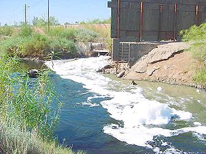
. The New River
New River (California)
The New River flows north from near Cerro Prieto, through the city of Mexicali, Baja California, Mexico, into the United States through the city of Calexico, California towards the Salton Sea...
and the Alamo River flow from the border city of Mexicali
Mexicali
Mexicali is the capital of the State of Baja California, seat of the Municipality of Mexicali, and 2nd largest city in Baja California. The City of Mexicali has a population of 689,775, according to the 2010 census, while the population of the entire metropolitan area reaches 936,826.The city...
northward to the Salton Sea.
Another popular destination is the Salton Sea mud pots and volcanoes. These mud pots and volcanoes are located in an open field on the eastern side of the Salton Sea. The mud is just above ambient temperature and you can walk right up to the vents. However, this is a natural system and temperatures will vary. Caution is advised. The location is host to a number of gray cones reaching heights of six feet (2 m) and depressions filled with bubbling mud. These features are the result of the geothermal activity in the area.
Off-roading on ATV's is also another popular activity for many Southern Californians visiting the Imperial Valley. Many people from San Diego often take part in this activity during the summer months. Heber Dunes State Vehicular Recreation Area is located south of El Centro and is a primarily used off-roading destination. The valley sand dune recreation area draws hundreds of thousands of off-road enthusiasts on good weekends. Outdoor enthusiasts will find plenty to do in the Imperial Valley. Another popular activity is bird watching due to natural habitats so abundant that bird watchers from around the globe come to glimpse rare species. The Imperial Valley combines water and sun to create a desert oasis that produces an array of excellent golf courses for all levels. Golf courses are in Holtville, Brawley and two in and around El Centro.
Fort Yuma
Fort YumaFort Yuma
Fort Yuma is a fort in California that is located in Imperial County, across the Colorado River from Yuma, Arizona. It was on the Butterfield Overland Mail route from 1858 until 1861 and was abandoned May 16, 1883, and transferred to the Department of the Interior. The Fort Yuma Indian School and a...
is located on the banks of the Colorado River
Colorado River
The Colorado River , is a river in the Southwestern United States and northwestern Mexico, approximately long, draining a part of the arid regions on the western slope of the Rocky Mountains. The watershed of the Colorado River covers in parts of seven U.S. states and two Mexican states...
in Winterhaven, California
Winterhaven, California
Winterhaven is a census-designated place in Imperial County, California. Winterhaven is located east of Pilot Knob, The population was 394 at the 2010 census, down from 529 at the 2000 census. It is part of the 'El Centro, California Metropolitan Statistical Area'...
. First established after the end of the Mexican-American War in 1848, it was originally located in the bottoms near the Colorado River, less than 1 miles (1.6 km) below the mouth of the Gila River
Gila River
The Gila River is a tributary of the Colorado River, 650 miles long, in the southwestern states of New Mexico and Arizona.-Description:...
. It was to defend the newly settled community of Yuma, Arizona
Yuma, Arizona
Yuma is a city in and the county seat of Yuma County, Arizona, United States. It is located in the southwestern corner of the state, and the population of the city was 77,515 at the 2000 census, with a 2008 Census Bureau estimated population of 90,041....
on the other side of the Colorado River and the nearby Mexican border
Mexico
The United Mexican States , commonly known as Mexico , is a federal constitutional republic in North America. It is bordered on the north by the United States; on the south and west by the Pacific Ocean; on the southeast by Guatemala, Belize, and the Caribbean Sea; and on the east by the Gulf of...
. In March 1851 the post was moved to a small elevation on the Colorado's west bank, opposite the present city of Yuma, Arizona, on the site of the former Mission Puerto de Purísima Concepción
Mission Puerto de Purísima Concepción
Mission Puerto de Purísima Concepción was founded in October, 1780, by Father Francisco Garcés. The settlement was not part of the California mission chain, but was administered as a part of the Arizona missions...
. This site had been occupied by Camp Calhoun, named for John C. Calhoun
John C. Calhoun
John Caldwell Calhoun was a leading politician and political theorist from South Carolina during the first half of the 19th century. Calhoun eloquently spoke out on every issue of his day, but often changed positions. Calhoun began his political career as a nationalist, modernizer, and proponent...
, established in 1849. Fort Yuma was established to protect the southern emigrant travel route to California and to attempt control of the warlike Yuma Indians in the surrounding 100 miles (160.9 km) area.

Blue Angels
NAF El Centro is the winter home of the U.S. Navy Flight Demonstration Squadron, The Blue AngelsBlue Angels
The United States Navy's Navy Flight Demonstration Squadron, popularly known as the Blue Angels, was formed in 1946 and is currently the oldest formal flying aerobatic team...
. NAF El Centro historically kicks off the Blue Angels' season with their first air show, traditionally held in March.
Imperial Valley Expo & Fairgrounds
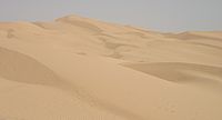
Home to the California Mid-Winter Fair and Fiesta which is the local county fair. It is also home to the Imperial Valley Speedway, a 3/8 mi race track.Algodones Sand Dunes
The name Algodones DunesAlgodones Dunes
The Algodones Dunes is a large erg located in the southeastern portion of the U.S. state of California, near the border with Arizona and the Mexican state of Baja California. The field is approximately 45 miles long by 6 miles wide and extends along a northwest-southeast line that correlates to...
refers to the entire geographic feature, while the administrative designation for that portion managed by the Bureau of Land Management
Bureau of Land Management
The Bureau of Land Management is an agency within the United States Department of the Interior which administers America's public lands, totaling approximately , or one-eighth of the landmass of the country. The BLM also manages of subsurface mineral estate underlying federal, state and private...
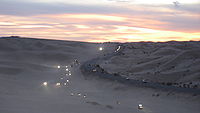
is the "Imperial Sand Dunes Recreation Area" (sometimes called the "Glamis Dunes"). The Algodones Sand Dunes are the largest mass of sand dunes in California. This dune system extends for more than 40 miles (64.4 km) along the eastern edge of the Imperial Valley agricultural region in a band averaging 5 miles (8 km) in width. A major east-west route of the Union Pacific railroad skirts the eastern edge.The dune system is divided into 3 areas. The northern most area is known as Mammoth Wash. South of Mammoth Wash is the North Algodones Dunes Wilderness established by the 1994 California Desert Protection Act. This area is closed to motorized use and access is by hiking and horseback. The largest and most heavily used area begins at Highway 78
California State Route 78
State Route 78 is a state highway in the U.S. state of California in the United States that runs from Oceanside east to Blythe, traversing nearly the entire width of the state. Its western terminus is at Interstate 5 in San Diego County and its eastern terminus is at I-10 in Riverside County...
and continues south just past Interstate 8
Interstate 8
Interstate 8 is an Interstate Highway in the southwestern United States. It runs from the southern edge of Mission Bay at Sunset Cliffs Blvd, in San Diego, California, almost at the Pacific Ocean, to the junction with Interstate 10, just southeast of Casa Grande, Arizona...
. The expansive dune formations offer picturesque scenery,, a chance to view rare plants and animals, and a playground for ATV
All-terrain vehicle
An all-terrain vehicle , also known as a quad, quad bike, three wheeler, or four wheeler, is defined by the American National Standards Institute as a vehicle that travels on low pressure tires, with a seat that is straddled by the operator, along with handlebars for steering control...
and off-roading enthusiasts. The dunes are also popular in film making and have been the site for movies such as Star Wars Episode VI: Return of the Jedi
Star Wars Episode VI: Return of the Jedi
Star Wars Episode VI: Return of the Jedi is a 1983 American epic space opera film directed by Richard Marquand and written by George Lucas and Lawrence Kasdan. It is the third film released in the Star Wars saga, and the sixth in terms of the series' internal chronology...
.
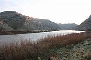
Colorado River
The Colorado RiverColorado River
The Colorado River , is a river in the Southwestern United States and northwestern Mexico, approximately long, draining a part of the arid regions on the western slope of the Rocky Mountains. The watershed of the Colorado River covers in parts of seven U.S. states and two Mexican states...
is a popular destination for water sports including fishing, boating, water-skiing, and jet-skiing. The Colorado River is a river in the southwestern United States and northwestern Mexico, approximately 2330 kilometres (1,447.8 mi) long, draining a part of the arid regions on the western slope of the Rocky Mountains
Rocky Mountains
The Rocky Mountains are a major mountain range in western North America. The Rocky Mountains stretch more than from the northernmost part of British Columbia, in western Canada, to New Mexico, in the southwestern United States...
. The natural course of the river flows from north of Grand Lake, Colorado into the Gulf of California
Gulf of California
The Gulf of California is a body of water that separates the Baja California Peninsula from the Mexican mainland...
. For many months out of the year, however, no water actually flows from the United States to the gulf, due to human consumption.
Salvation Mountain
Salvation MountainSalvation Mountain
Salvation Mountain is a colorful art installation covering much of a small hill north of Calipatria, California, near Slab City and just several miles from the Salton Sea. It is made from adobe, straw, and thousands of gallons of paint...
(location 33°15′14.9"N 115°28′21.4"W) is a colorful artificial mountain north of Calipatria, California
Calipatria, California
Calipatria is a city in Imperial County, California. Calipatria is located north of El Centro, It is part of the El Centro Metropolitan Area. The population was 7,705 at the 2010 census, up from 7,289 at the 2000 census, including 4000 inmates at Calipatria State Prison...
, near Slab City
Slab City
Slab City or The Slabs is a camp in the Colorado Desert in southeastern California, used by recreational vehicle owners and squatters from across North America. It takes its name from the concrete slabs and pylons that remain from the abandoned World War II Marine barracks Camp Dunlap there...
. It is made from adobe, straw, and thousands of gallons of paint. It was created by Leonard Knight
Leonard Knight
Leonard Knight is the builder and chief architect of Salvation Mountain. He lives at the mountain near Slab City, a few miles from Niland, California, and approximately from San Diego.-Childhood:...
to convey the message that "God Loves Everyone". Mr. Knight refused substantial donations of money and labor from supporters who wished to modify his message of universal love to favor or disfavor particular groups.
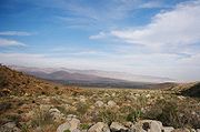
Anza-Borrego Desert State Park
Anza-Borrego Desert State ParkAnza-Borrego Desert State Park
Anza-Borrego Desert State Park is a state park located within the Colorado Desert of Southern California. The park takes its name from 18th century, Spanish explorer Juan Bautista de Anza and borrego, the Spanish word for bighorn sheep...
, portions of which are located in Imperial County, is the largest state park in California
California
California is a state located on the West Coast of the United States. It is by far the most populous U.S. state, and the third-largest by land area...
. 500 miles (804.7 km) of dirt roads, 12 wilderness areas and miles of hiking trails provide visitors with an unparalleled opportunity to experience the wonders of the Colorado Desert
Colorado Desert
California's Colorado Desert is a part of the larger Sonoran Desert, which extends across southwest North America. The Colorado Desert region encompasses approximately , reaching from the Mexican border in the south to the higher-elevation Mojave Desert in the north and from the Colorado River in...
. The park is named after Spanish explorer Juan Bautista de Anza
Juan Bautista de Anza
Juan Bautista de Anza Bezerra Nieto was a Novo-Spanish explorer and Governor of New Mexico for the Spanish Empire.-Early life:...
and the Spanish name borrego, or bighorn sheep
Bighorn Sheep
The bighorn sheep is a species of sheep in North America named for its large horns. These horns can weigh up to , while the sheep themselves weigh up to . Recent genetic testing indicates that there are three distinct subspecies of Ovis canadensis, one of which is endangered: Ovis canadensis sierrae...
. The park features washes, wildflowers, palm groves, cacti
Cactus
A cactus is a member of the plant family Cactaceae. Their distinctive appearance is a result of adaptations to conserve water in dry and/or hot environments. In most species, the stem has evolved to become photosynthetic and succulent, while the leaves have evolved into spines...
and sweeping vistas. Visitors may also have the chance to see Greater Roadrunner
Greater Roadrunner
The Greater Roadrunner, taxonomically classified as Geococcyx californianus, meaning "Californian Earth-cuckoo," is a long-legged bird in the cuckoo family, Cuculidae. Along with the Lesser Roadrunner, it is one of two species in the roadrunner genus Geococcyx...
s, Golden Eagle
Golden Eagle
The Golden Eagle is one of the best known birds of prey in the Northern Hemisphere. Like all eagles, it belongs to the family Accipitridae. Once widespread across the Holarctic, it has disappeared from many of the more heavily populated areas...
s, Kit Fox
Kit Fox
The kit fox is a fox species of North America. Its range is primarily in the southwestern United States and northern and central Mexico. Some mammalogists classify it as conspecific with the swift fox, V. velox, but molecular systematics imply that the two species are distinct.-Range:The...
es, Southern Mule Deer
Mule Deer
The mule deer is a deer indigenous to western North America. The Mule Deer gets its name from its large mule-like ears. There are believed to be several subspecies, including the black-tailed deer...
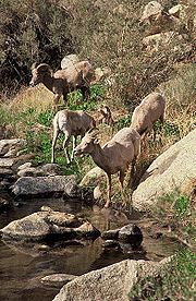
and Peninsular Bighorn Sheep
Bighorn Sheep
The bighorn sheep is a species of sheep in North America named for its large horns. These horns can weigh up to , while the sheep themselves weigh up to . Recent genetic testing indicates that there are three distinct subspecies of Ovis canadensis, one of which is endangered: Ovis canadensis sierrae...
, as well as Desert Iguana
Desert iguana
The desert iguana is one of the most common lizards of the Sonoran and Mojave deserts of the southwestern United States and northwestern Mexico...
s, Chuckwallas, and Sidewinder
Crotalus cerastes
Crotalus cerastes is a venomous pitviper species found in the desert regions of the southwestern United States and northwestern Mexico. Three subspecies are currently recognized, including the nominate subspecies described here.-Description:...
s.
Fossil Canyon and Painted Gorge
Located near Ocotillo, CaliforniaOcotillo, California
Ocotillo is a census-designated place in Imperial County, California. Ocotillo is located west of El Centro, The population was 266 at the 2010 census, down from 296 at the 2000 census...
in the Coyote Mountains
Coyote Mountains
The Coyote Mountains are a mountain range in San Diego County, California....
, Fossil Canyon and the surrounding area is a great place for rock hounding and fossil
Fossil
Fossils are the preserved remains or traces of animals , plants, and other organisms from the remote past...
hunting. The fossils here are not dinosaurs, but ancient shell
Seashell
A seashell or sea shell, also known simply as a shell, is a hard, protective outer layer created by an animal that lives in the sea. The shell is part of the body of the animal. Empty seashells are often found washed up on beaches by beachcombers...
s, coral
Coral
Corals are marine animals in class Anthozoa of phylum Cnidaria typically living in compact colonies of many identical individual "polyps". The group includes the important reef builders that inhabit tropical oceans and secrete calcium carbonate to form a hard skeleton.A coral "head" is a colony of...
, and oysters from the Miocene epoch
Miocene
The Miocene is a geological epoch of the Neogene Period and extends from about . The Miocene was named by Sir Charles Lyell. Its name comes from the Greek words and and means "less recent" because it has 18% fewer modern sea invertebrates than the Pliocene. The Miocene follows the Oligocene...
when the area was underwater.
The Painted Gorge, located on the eastern side of the Coyote Mountains, consists of sedimentary, metamorphic and igneous rocks. Heat
Heat
In physics and thermodynamics, heat is energy transferred from one body, region, or thermodynamic system to another due to thermal contact or thermal radiation when the systems are at different temperatures. It is often described as one of the fundamental processes of energy transfer between...
and movement over time has created fantastic shapes and colors. Oranges, reds, purples, and mauves mixed with browns and blacks create a palette of color as the sun illuminates and plays shadows upon this geologic wonder.
Imperial NWR
The Imperial National Wildlife RefugeImperial National Wildlife Refuge
The Imperial National Wildlife Refuge protects wildlife habitat along of the lower Colorado River in Arizona and California, including the last un-channeled section before the river enters Mexico...
protects wildlife habitat along 30 miles (48.3 km) of the lower Colorado River
Colorado River
The Colorado River , is a river in the Southwestern United States and northwestern Mexico, approximately long, draining a part of the arid regions on the western slope of the Rocky Mountains. The watershed of the Colorado River covers in parts of seven U.S. states and two Mexican states...
in Arizona
Arizona
Arizona ; is a state located in the southwestern region of the United States. It is also part of the western United States and the mountain west. The capital and largest city is Phoenix...
and California
California
California is a state located on the West Coast of the United States. It is by far the most populous U.S. state, and the third-largest by land area...
, including the last un-channeled section before the river enters Mexico
Mexico
The United Mexican States , commonly known as Mexico , is a federal constitutional republic in North America. It is bordered on the north by the United States; on the south and west by the Pacific Ocean; on the southeast by Guatemala, Belize, and the Caribbean Sea; and on the east by the Gulf of...
. The river and its associated backwater lakes and wetlands are a green oasis, contrasting with the surrounding desert mountains. It is a refuge and breeding area for migratory birds and local desert wildlife.
Sonny Bono Salton Sea NWR
The Sonny Bono Salton Sea National Wildlife RefugeSonny Bono Salton Sea National Wildlife Refuge
The Sonny Bono Salton Sea National Wildlife Refuge is located north of the Mexican border at the southern end of the Salton Sea in California’s Imperial Valley. Situated along the Pacific Flyway, the Refuge is the only one of its kind, located below sea level...
is located 40 miles (64.4 km) north of the Mexican
Mexico
The United Mexican States , commonly known as Mexico , is a federal constitutional republic in North America. It is bordered on the north by the United States; on the south and west by the Pacific Ocean; on the southeast by Guatemala, Belize, and the Caribbean Sea; and on the east by the Gulf of...
border at the southern end of the Salton Sea in California’s Imperial Valley. Situated along the Pacific Flyway
Pacific Flyway
The Pacific Flyway is a major north-south route of travel for migratory birds in America, extending from Alaska to Patagonia. Every year, migratory birds travel some or all of this distance both in spring and in fall, following food sources, heading to breeding grounds, or travelling to...
, the refuge is the only one of its kind, located 227 feet (69 m) below sea level. Because of its southern latitude, elevation and location in the Colorado Desert
Colorado Desert
California's Colorado Desert is a part of the larger Sonoran Desert, which extends across southwest North America. The Colorado Desert region encompasses approximately , reaching from the Mexican border in the south to the higher-elevation Mojave Desert in the north and from the Colorado River in...
, the refuge experiences some of the highest temperatures in the nation. Daily temperatures from May to October generally exceed 100°F with temperatures of 116°-120°F recorded yearly.
Mexicali
The border city of Mexicali, Baja California, MexicoMexico
The United Mexican States , commonly known as Mexico , is a federal constitutional republic in North America. It is bordered on the north by the United States; on the south and west by the Pacific Ocean; on the southeast by Guatemala, Belize, and the Caribbean Sea; and on the east by the Gulf of...
, offers big city amenities like museums, a zoo, a sports convention center, and an international airport. Visitors cross by foot or car from Calexico, California
Calexico, California
Calexico is a city in Imperial County, California. The population was 38,572 at the 2010 census, up from 27,109 at the 2000 census. Calexico is about east of San Diego and west of Yuma, Arizona...
in the United States
United States
The United States of America is a federal constitutional republic comprising fifty states and a federal district...
every day. Restaurants and taco stands, pharmacies, bars and dance clubs are part of the draw for the city's tourists. Many shops and stalls selling Mexican crafts and souvenirs are also located in walking distance from the border. Also many residents from California
California
California is a state located on the West Coast of the United States. It is by far the most populous U.S. state, and the third-largest by land area...
, Arizona
Arizona
Arizona ; is a state located in the southwestern region of the United States. It is also part of the western United States and the mountain west. The capital and largest city is Phoenix...
and Nevada
Nevada
Nevada is a state in the western, mountain west, and southwestern regions of the United States. With an area of and a population of about 2.7 million, it is the 7th-largest and 35th-most populous state. Over two-thirds of Nevada's people live in the Las Vegas metropolitan area, which contains its...
look for medical and dental services in Mexicali, because they tend to be less expensive than those in the United States. Mexico's drinking age of 18 (vs. 21 in the United States) makes it a common weekend destination for many high school and college aged Southern Californians. The town was near the epicenter
Epicenter
The epicenter or epicentre is the point on the Earth's surface that is directly above the hypocenter or focus, the point where an earthquake or underground explosion originates...
of the 2010 Baja California earthquake
2010 Baja California earthquake
The 2010 Baja California earthquake was an earthquake of 7.2 magnitude on the moment magnitude scale. It started south of Guadalupe Victoria, Baja California, Mexico, at a depth of . It occurred at 3:40:41 p.m...
(on Easter Sunday, April 4, 2010).
Agriculture
Colorado Desert
California's Colorado Desert is a part of the larger Sonoran Desert, which extends across southwest North America. The Colorado Desert region encompasses approximately , reaching from the Mexican border in the south to the higher-elevation Mojave Desert in the north and from the Colorado River in...
section of the Sonoran Desert
Sonoran Desert
The Sonoran Desert is a North American desert which straddles part of the United States-Mexico border and covers large parts of the U.S. states of Arizona and California and the northwest Mexican states of Sonora, Baja California, and Baja California Sur. It is one of the largest and hottest...
, with high temperatures and low average rainfall of 3 inches (75 mm) per year, the economy is heavily based on agriculture due to irrigation, which is supplied wholly from the Colorado River
Colorado River
The Colorado River , is a river in the Southwestern United States and northwestern Mexico, approximately long, draining a part of the arid regions on the western slope of the Rocky Mountains. The watershed of the Colorado River covers in parts of seven U.S. states and two Mexican states...
via the All-American Canal
All-American Canal
The All-American Canal is an long aqueduct, located in southeastern California. It conveys water from the Colorado River into the Imperial Valley and to nine cities. It is the Imperial Valley's only water source, and replaced the Alamo Canal, which was located mostly in Mexico...
. Thousands of acres of prime farmland have transformed the desert into one of the most productive farming regions in California with an annual crop production of over $1 billion. Agriculture is the largest industry in the Imperial Valley and accounts for 48% of all employment. An environmental cost is that, south of the canal, the Colorado River
Colorado River
The Colorado River , is a river in the Southwestern United States and northwestern Mexico, approximately long, draining a part of the arid regions on the western slope of the Rocky Mountains. The watershed of the Colorado River covers in parts of seven U.S. states and two Mexican states...
no longer flows at all for much of the year.
A vast system of canals, check dams, and pipelines carry the water all over the valley, a system which forms the Imperial Irrigation District
Imperial Irrigation District
The Imperial Irrigation District was formed in 1911 under the California Irrigation District Act to acquire the properties of the bankrupt California Development Company and its Mexican subsidiary. The IID had acquired 13 mutual water companies, which had developed and operated distribution canals...
, or IID. The water distribution system includes over 1400 miles (2,253.1 km) of canal and with 1100 miles (1,770.3 km) of pipeline. The number of canal and pipeline branches number roughly over a hundred. Imported water and a long growing season allow two crop cycles each year, and the Imperial Valley is a major source of winter fruits and vegetables, cotton, and grain for U.S. and international markets. Alfalfa
Alfalfa
Alfalfa is a flowering plant in the pea family Fabaceae cultivated as an important forage crop in the US, Canada, Argentina, France, Australia, the Middle East, South Africa, and many other countries. It is known as lucerne in the UK, France, Australia, South Africa and New Zealand, and known as...
is another major crop produced in the Imperial Valley. The agricultural lands are served by a constructed agricultural drain system, which conveys surface runoff and subsurface drainage from fields to the Salton Sea, which is a designated repository for agricultural runoff, with environmental considerations not yet solved.
- All-American CanalAll-American CanalThe All-American Canal is an long aqueduct, located in southeastern California. It conveys water from the Colorado River into the Imperial Valley and to nine cities. It is the Imperial Valley's only water source, and replaced the Alamo Canal, which was located mostly in Mexico...
- All-American Canal BridgeAll-American Canal BridgeThe All-American Canal Bridge is a bridge that carries Interstate 8 over the All-American Canal, a canal that supplies water from the Colorado River to the agricultural areas of the Imperial Valley....
- Alamo CanalAlamo CanalThe Alamo Canal was a long waterway that connected the Colorado River to the head of the Alamo River. The canal was constructed to provide irrigation to the Imperial Valley. A small portion of the canal was located in the United States but the majority of the canal was located in Mexico...
- Coachella CanalCoachella CanalThe Coachella Canal is a aqueduct that conveys Colorado River water for irrigation from the All-American Canal to the Coachella Valley in Riverside County, California....
- Imperial Irrigation DistrictImperial Irrigation DistrictThe Imperial Irrigation District was formed in 1911 under the California Irrigation District Act to acquire the properties of the bankrupt California Development Company and its Mexican subsidiary. The IID had acquired 13 mutual water companies, which had developed and operated distribution canals...
- Imperial Land CompanyImperial Land CompanyThe Imperial Land Company was a land colonization company incorporated in California in March, 1900 for the purpose of encouraging settlement of the Imperial Valley thus providing customers for the California Development Company...
- California Development CompanyCalifornia Development CompanyThe California Development Company was formed in 1896 as a replacement for the defunct Colorado River Irrigation Company, which had been started a few years earlier for the purpose of planning an irrigation system for the lower Colorado Desert in California...
Renewable Energy

Much of the land suitable for green energy is owned by the federal government (Bureau of Land Management
Bureau of Land Management
The Bureau of Land Management is an agency within the United States Department of the Interior which administers America's public lands, totaling approximately , or one-eighth of the landmass of the country. The BLM also manages of subsurface mineral estate underlying federal, state and private...
). As of April 2008, the BLM has received 163 applications to build renewable energy projects on 1600000 acres (6,475 km²) in California, "almost all of them are planned for the Imperial Valley and the desert region north of the valley." Stirling Energy is currently building one of the world's largest solar thermal plants, 10 square miles (25.9 km²) with 38,000 "sun catchers," it will power up to 600,000 homes once it is fully operational by around 2015. CalEnergy currently runs a geothermal plant that generates 340 megawatts, enough power for 300,000 homes, and could tap into more for up to 2.5 million homes.
Demographics
The Imperial and Mexicali Valleys share a common international bond of both American and HispanicHispanic
Hispanic is a term that originally denoted a relationship to Hispania, which is to say the Iberian Peninsula: Andorra, Gibraltar, Portugal and Spain. During the Modern Era, Hispanic sometimes takes on a more limited meaning, particularly in the United States, where the term means a person of ...
cultures. On the U.S. side, the majority of residents are of Mexican-American or Latino
Latino
The demonyms Latino and Latina , are defined in English language dictionaries as:* "a person of Latin-American descent."* "A Latin American."* "A person of Hispanic, especially Latin-American, descent, often one living in the United States."...
heritage, while the Mexican side has been greatly influenced by American culture by the U.S. for many decades. The entire valley has multi-racial representation of Africans, Europeans, east and south Asians, and Native Americans.
As of the census of 2000, there were 142,361 people, 39,384 households, and 31,467 families residing in the county. The population density was 34 people per square mile (13/km²). There were 43,891 housing units at an average density of 10 per square mile (4/km²). The racial makeup of the county was 49.37% White, 3.95% Black or African American, 1.87% Native American, 1.99% Asian, 0.08% Pacific Islander, 39.08% from other races, and 3.65% from two or more races. 72.22% of the population were Hispanic or Latino of any race. 65.7% spoke Spanish and 32.3% English as their first language.
There were 39,384 households out of which 46.7% had children under the age of 18 living with them, 57.7% were married couples living together, 17.1% had a female householder with no husband present, and 20.1% were non-families. 17.1% of all households were made up of individuals and 8.1% had someone living alone who was 65 years of age or older. The average household size was 3.33 and the average family size was 3.77.In the county the population was spread out with 31.4% under the age of 18, 9.9% from 18 to 24, 30.4% from 25 to 44, 18.2% from 45 to 64, and 10.0% who were 65 years of age or older. The median age was 31 years. For every 100 females there were 109.3 males. For every 100 females age 18 and over, there were 111.4 males.
| Year | DEM Democratic Party (United States) The Democratic Party is one of two major contemporary political parties in the United States, along with the Republican Party. The party's socially liberal and progressive platform is largely considered center-left in the U.S. political spectrum. The party has the lengthiest record of continuous... |
GOP Republican Party (United States) The Republican Party is one of the two major contemporary political parties in the United States, along with the Democratic Party. Founded by anti-slavery expansion activists in 1854, it is often called the GOP . The party's platform generally reflects American conservatism in the U.S... |
Others |
|---|---|---|---|
| 2008 | 61.1% 17,761 | 37.3% 10,850 | 1.6% 459 |
| 2004 | 52.4% 17,964 | 46.4% 15,890 | 1.2% 420 |
| 2000 | 53.5% 15,489 | 43.3% 12,524 | 3.2% 924 |
| 1996 | 55.3% 14,591 | 36.8% 9,705 | 8.0% 2,104 |
| 1992 | 43.9% 11,109 | 38.5% 9,759 | 17.6% 4,450 |
| 1988 | 43.8% 10,243 | 55.2% 12,889 | 1.0% 233 |
| 1984 | 36.9% 8,237 | 62.0% 13,829 | 1.1% 235 |
| 1980 | 36.9% 7,961 | 55.9% 12,068 | 7.2% 1,550 |
| 1976 | 48.2% 10,244 | 49.9% 10,618 | 1.9% 400 |
| 1972 | 34.9% 7,982 | 62.1% 14,178 | 3.0% 689 |
Politics
Imperial County is a Democratic stronghold in Presidential, Congressional and local elections. The last Republican to win a majority in the county was George H. W. BushGeorge H. W. Bush
George Herbert Walker Bush is an American politician who served as the 41st President of the United States . He had previously served as the 43rd Vice President of the United States , a congressman, an ambassador, and Director of Central Intelligence.Bush was born in Milton, Massachusetts, to...
in 1988
United States presidential election, 1988
The United States presidential election of 1988 featured no incumbent president, as President Ronald Reagan was unable to seek re-election after serving the maximum two terms allowed by the Twenty-second Amendment. Reagan's Vice President, George H. W. Bush, won the Republican nomination, while the...
.
On November 4, 2008, Imperial County voted 69.7% for Proposition 8, which amended the California Constitution to ban same-sex marriages, showing more support for the proposition than any other strongly Democratic county.
Imperial is part of California's 51st congressional district
California's 51st congressional district
California's 51st congressional district is a congressional district in the U.S. state of California. The district includes all of Imperial County and the extreme southern portions of San Diego County that run across the U.S.-Mexico border...
, which is held by Democrat Bob Filner
Bob Filner
Robert Earl Filner is the U.S. Representative for , and previously the 50th, serving since 1993, and Chairman of the House Committee on Veterans' Affairs since 2007. He is a member of the Democratic Party...
. In the state legislature
California State Legislature
The California State Legislature is the state legislature of the U.S. state of California. It is a bicameral body consisting of the lower house, the California State Assembly, with 80 members, and the upper house, the California State Senate, with 40 members...
, Imperial is part of the 80th Assembly district, which is held by Democrat Manuel Perez
Manuel Perez (politician)
V. Manuel Pérez is a Democratic Assemblymember from California's 80th State Assembly district from Coachella, California, United States.-Biography:...
, and the 40th Senate district, which is held by Democrat Denise Ducheny
Denise Moreno Ducheny
Denise Moreno Ducheny is a California State Senator who represents Senate District 40, which includes southern San Diego County, part of Riverside County, and all of Imperial County. Ducheny is a Democrat. She lives with her husband, Al, in San Diego, California.-Background:Ducheny was born in...
.
The median income for a household in the county was $31,870, and the median income for a family was $35,226. Males had a median income of $32,775 versus $23,974 for females. The per capita income for the county was $13,239. About 19.4% of families and 22.6% of the population were below the poverty line, including 28.7% of those under age 18 and 13.6% of those age 65 or over.
Schools In The Imperial Valley
The Imperial Valley has many schools to offer education; high schools, middle/junior high school, elementary schools, and college. Central Union High SchoolCentral Union High School (El Centro, California)
Central Union High School, also known as Central or CUHS, is a four-year public high school in El Centro, California with a diverse student body of more than 1,750 students. It is one of three schools in the Central Union High School District...
, Southwest High School
Southwest High School (El Centro, California)
Southwest High School, known as Southwest or SHS, is a 4 year public high school in El Centro, California that serves approximately 2,200 students. Southwest is one of the 3 high schools within the Central Union High School District. It has been a California Distinguished School...
and Brawley Union High School
Brawley Union High School
Brawley Union High School is a high school in Brawley, California.-Clubs:*Environmental Club*Campus Life*Theatre/Drama*Rotary Interact*Friday Night Live*S Club*California Scholastic Federation*AVID* American Field Service*Travel...
are some of the high schools Imperial Valley has to offer. Imperial Valley College
Imperial Valley College
Imperial Valley College is a college in Imperial County, California, USA. Founded in 1962 the college currently enrolls around 7,000 students per year. Currently, Ed Gould is President of the college. The main campus is located on a site in the city of Imperial...
, located in Imperial, California and SDSU
San Diego State University
San Diego State University , founded in 1897 as San Diego Normal School, is the largest and oldest higher education facility in the greater San Diego area , and is part of the California State University system...
Imperial Valley Extension, located in Calexico, CA are the colleges the Imperial Valley has to offer. The major high school rivals in the valley are the Central Union High School "Spartans" and Brawley Union High School "Wildcats"- these high school play an annual football game called the "Bell Game", whoever wins the game is victorious in the Imperial Valley League and keeps the bell. For two consecutive years (since 2008), the Spartans have kept the bell home up until 2011 where the Wildcats regained the bell. The bell game is held the second Friday of November. It is a game that almost everyone in the valley attends; the game gets very packed, the bleachers alway get full, and it gets full all around the football field.
Imagine School at Imperial Valley is a newly opened public charter school that will eventually serve students in grades K-8.
Major highways
.svg.png) Interstate 8
Interstate 8 State Route 7
 State Route 78California State Route 78State Route 78 is a state highway in the U.S. state of California in the United States that runs from Oceanside east to Blythe, traversing nearly the entire width of the state. Its western terminus is at Interstate 5 in San Diego County and its eastern terminus is at I-10 in Riverside County...
 State Route 86California State Route 86State Route 86 is a north–south state highway in the southeastern desert region of Southern California, United States. It runs from State Route 111, near the Mexican border crossing at Calexico, north through the Imperial Valley via El Centro and Brawley, and around the west side of the...
 State Route 98
 State Route 111California State Route 111State Route 111 is a state highway in the U.S. state of California. It is the main north/south state highway and retail corridor through the Coachella Valley, a part of the Colorado Desert in the southeastern corner of the state and famous as a resort destination...
 State Route 115California State Route 115State Route 115 is a state highway in the U.S. state of California. It runs from Interstate 8 southeast of Holtville to Calipatria in Imperial County...
Airports
Imperial County Airport is the main airport in the county. It is primarily a general aviation airport with limited commercial flight service. The major nearby airport is the San Diego International AirportSan Diego International Airport
San Diego International Airport , sometimes referred to as Lindbergh Field, is a public airport located northwest of the central business district of San Diego, California and from the Mexico – United States border at Tijuana, Mexico...
.
| Airport Airport An airport is a location where aircraft such as fixed-wing aircraft, helicopters, and blimps take off and land. Aircraft may be stored or maintained at an airport... |
IATA code IATA airport code An IATA airport code, also known an IATA location identifier, IATA station code or simply a location identifier, is a three-letter code designating many airports around the world, defined by the International Air Transport Association... |
ICAO code ICAO airport code The ICAO airport code or location indicator is a four-character alphanumeric code designating each airport around the world. These codes are defined by the International Civil Aviation Organization, and published in ICAO Document 7910: Location Indicators.The ICAO codes are used by air traffic... |
City |
|---|---|---|---|
| Calexico International Airport Calexico International Airport Calexico International Airport is a city-owned public-use airport located one mile west of the central business district of Calexico, in Imperial County, California, United States. The airport is mostly used for general aviation and to facilitate border crossing... |
CXL | KCXL | Calexico Calexico, California Calexico is a city in Imperial County, California. The population was 38,572 at the 2010 census, up from 27,109 at the 2000 census. Calexico is about east of San Diego and west of Yuma, Arizona... |
| Holtville Airport | L04 | none | Holtville Holtville, California Holtville is a city in Imperial County, California. Holtville is located east of El Centro, The population was 5,939 at the 2010 census, up from 5,612 at the 2000 census. It is part of the 'El Centro, California, Metropolitan Statistical Area'... |
| Imperial County Airport Imperial County Airport Imperial County Airport , also known as Boley Field, is a public airport located partially in the city of Imperial and partially in an unincorporated area in Imperial County, California, United States. The airport is located 0.94 miles south of the central business district of Imperial. The... |
IPL | KIPL | Imperial Imperial, California Imperial is a city in Imperial County, California. Imperial is located north of El Centro. As of the 2010 census, the city had a population of 14,758. It is part of the El Centro metropolitan area. The City of Imperial is a bustling center in the Imperial Valley due to its central location in The... |
Culture
Robert A. HeinleinRobert A. Heinlein
Robert Anson Heinlein was an American science fiction writer. Often called the "dean of science fiction writers", he was one of the most influential and controversial authors of the genre. He set a standard for science and engineering plausibility and helped to raise the genre's standards of...
's science fiction short story "Water is for Washing
Water is for Washing
"Water is for Washing" is a science fiction short story by Robert A. Heinlein, first published in Argosy and based on the premise that an earthquake had catastrophically shattered the range of alluvial deposits separating the Imperial Valley from the Gulf of California, precipitating a tidal wave...
" (Argosy
Argosy (magazine)
Argosy was an American pulp magazine, published by Frank Munsey. It is generally considered to be the first American pulp magazine. The magazine began as a general information periodical entitled The Golden Argosy, targeted at the boys adventure market.-Launch of Argosy:In late September 1882,...
, November 1947) was based on the premise that an earthquake had catastrophically shattered the range of deposits separating the Imperial Valley from the Gulf of California
Gulf of California
The Gulf of California is a body of water that separates the Baja California Peninsula from the Mexican mainland...
, precipitating a tidal wave
Tsunami
A tsunami is a series of water waves caused by the displacement of a large volume of a body of water, typically an ocean or a large lake...
moving north to transiently drown these lowlands. At the beginning of the story, Heinlein uses the character of a bartender in El Centro to establish the danger of the quake and inundation:
- "You've heard about the 1905 flood, when the Colorado River spilled over and formed the Salton SeaSalton SeaThe Salton Sea is a shallow, saline, endorheic rift lake located directly on the San Andreas Fault, predominantly in California's Imperial Valley. The lake occupies the lowest elevations of the Salton Sink in the Colorado Desert of Imperial and Riverside counties in Southern California. Like Death...
? But don't be too sure about quakes; valleys below sea level don't just grow — something has to cause them. The San Andreas FaultSan Andreas FaultThe San Andreas Fault is a continental strike-slip fault that runs a length of roughly through California in the United States. The fault's motion is right-lateral strike-slip...
curls around this valley like a question mark. Just imagine the shake-up it must have taken to drop thousands of square miles below the level of the Pacific."
Heinlein's perspective character is a traveling businessman who had picked up two chance-encountered children and a vagrant
Vagrancy (people)
A vagrant is a person in poverty, who wanders from place to place without a home or regular employment or income.-Definition:A vagrant is "a person without a settled home or regular work who wanders from place to place and lives by begging;" vagrancy is the condition of such persons.-History:In...
while driving frantically to higher ground, and the dramatic arc centers on the efforts of the men to survive and save the youngsters from drowning.
Due to its desert environment and proximity to Los Angeles, California
Los Angeles, California
Los Angeles , with a population at the 2010 United States Census of 3,792,621, is the most populous city in California, USA and the second most populous in the United States, after New York City. It has an area of , and is located in Southern California...
, movies are sometimes filmed in the sand dunes outside the agricultural portions of the Imperial Valley. These have included
- Star Wars Episode VI: Return of the JediStar Wars Episode VI: Return of the JediStar Wars Episode VI: Return of the Jedi is a 1983 American epic space opera film directed by Richard Marquand and written by George Lucas and Lawrence Kasdan. It is the third film released in the Star Wars saga, and the sixth in terms of the series' internal chronology...
- Independence DayIndependence Day (film)Independence Day is a 1996 science fiction film about an alien invasion of Earth, focusing on a disparate group of individuals and families as they converge in the Nevada desert and, along with the rest of the human population, participate in a last-chance counterattack on July 4 – the same...
- StargateStargate (film)Stargate is a 1994 American adventure-military science fiction film released through Metro-Goldwyn-Mayer and Carolco Pictures. Created by Dean Devlin and Roland Emmerich, the film is the first release in the Stargate franchise...
- The Scorpion KingThe Scorpion KingThe Scorpion King is a 2002 American action film directed by Chuck Russell, starring Dwayne "The Rock" Johnson, Kelly Hu, Grant Heslov, and Michael Clarke Duncan...
- Into the WildInto the Wild (film)Into the Wild is a 2007 American biographical drama film directed by Sean Penn. It is an adaptation of 1996 non-fiction book of the same name by Jon Krakauer based on the travels of Christopher McCandless across North America in the early 1990s. The film stars Emile Hirsch as McCandless with...
- The original "Flight of the Phoenix" (1965) was Filmed outside of Holtville.
- The Tom Cruise Movie "Losin' It" (1983) was filmed in Holtville and El Centro.
Additionally, portions of the 2005 film Jarhead
Jarhead (film)
Jarhead is a 2005 biographical drama war film based on U.S. Marine Anthony Swofford's 1991 Gulf War memoir of the same name, directed by Sam Mendes, starring Jake Gyllenhaal as Swofford with co-stars Jamie Foxx, Peter Sarsgaard, and Chris Cooper. The title comes from the slang term used to refer to...
were filmed here because of its similarity to the desert
Desert
A desert is a landscape or region that receives an extremely low amount of precipitation, less than enough to support growth of most plants. Most deserts have an average annual precipitation of less than...
terrain of Iraq
Iraq
Iraq ; officially the Republic of Iraq is a country in Western Asia spanning most of the northwestern end of the Zagros mountain range, the eastern part of the Syrian Desert and the northern part of the Arabian Desert....
. Mountains that were visible in the background during filming were digitally removed during postproduction.http://akas.imdb.com/title/tt0418763/