

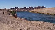
All-American Canal
Encyclopedia

Colorado River
The Colorado River , is a river in the Southwestern United States and northwestern Mexico, approximately long, draining a part of the arid regions on the western slope of the Rocky Mountains. The watershed of the Colorado River covers in parts of seven U.S. states and two Mexican states...
into the Imperial Valley and to nine cities. It is the Imperial Valley's only water source, and replaced the Alamo Canal
Alamo Canal
The Alamo Canal was a long waterway that connected the Colorado River to the head of the Alamo River. The canal was constructed to provide irrigation to the Imperial Valley. A small portion of the canal was located in the United States but the majority of the canal was located in Mexico...
, which was located mostly in Mexico. The Imperial Dam
Imperial Dam
The Imperial Diversion Dam is a concrete slab and buttress, ogee weir structure across the California/Arizona border, northeast of Yuma. Completed in the 1938, the dam retains the waters of the Colorado River into the Imperial Reservoir before desilting and diversion into the All-American Canal,...
, about 30 miles (48.3 km) northeast of Yuma, Arizona
Yuma, Arizona
Yuma is a city in and the county seat of Yuma County, Arizona, United States. It is located in the southwestern corner of the state, and the population of the city was 77,515 at the 2000 census, with a 2008 Census Bureau estimated population of 90,041....
on the Colorado River, diverts water into the All-American Canal, which runs to just west of Calexico, California
Calexico, California
Calexico is a city in Imperial County, California. The population was 38,572 at the 2010 census, up from 27,109 at the 2000 census. Calexico is about east of San Diego and west of Yuma, Arizona...
before its last branch heads mostly north into the Imperial Valley. Six smaller canals branching off the All American Canal move water into the Imperial Valley. These canal systems irrigates up to 630000 acres (254,952.2 ha) of good crop land and has made possible a greatly increased crop yield in this originally semi-desert area. It is the largest irrigation canal in the world, carrying a maximum of 26155 cuft/s. Agricultural runoff
Surface runoff
Surface runoff is the water flow that occurs when soil is infiltrated to full capacity and excess water from rain, meltwater, or other sources flows over the land. This is a major component of the water cycle. Runoff that occurs on surfaces before reaching a channel is also called a nonpoint source...
from the All American Canal drains into the Salton Sea
Salton Sea
The Salton Sea is a shallow, saline, endorheic rift lake located directly on the San Andreas Fault, predominantly in California's Imperial Valley. The lake occupies the lowest elevations of the Salton Sink in the Colorado Desert of Imperial and Riverside counties in Southern California. Like Death...
.
The All American Canal runs parallel to the Mexico California border for several miles and with over 500 people having drowned in the canal since 1997, it has been called "the Most Dangerous Body of Water in the U.S."
History
The All-American Canal was authorized along with the Hoover DamHoover Dam
Hoover Dam, once known as Boulder Dam, is a concrete arch-gravity dam in the Black Canyon of the Colorado River, on the border between the US states of Arizona and Nevada. It was constructed between 1931 and 1936 during the Great Depression and was dedicated on September 30, 1935, by President...
by the 1928 Boulder Canyon Project Act and built in the 1930s by the United States Bureau of Reclamation
United States Bureau of Reclamation
The United States Bureau of Reclamation , and formerly the United States Reclamation Service , is an agency under the U.S...
and Six Companies, Inc.. Its design and construction was supervised by the Bureau's then chief designing engineer, John L. Savage
John L. Savage
John Lucian Savage was an American civil engineer. He is best known for supervising the design and construction of the Hoover Dam, Shasta Dam and Grand Coulee Dam in the United States along with surveying for the future Three Gorges Dam in China...
and was completed in 1942.
Irrigation
The Bureau of Reclamation owns the canal, but the Imperial Irrigation DistrictImperial Irrigation District
The Imperial Irrigation District was formed in 1911 under the California Irrigation District Act to acquire the properties of the bankrupt California Development Company and its Mexican subsidiary. The IID had acquired 13 mutual water companies, which had developed and operated distribution canals...
operates it. Water for the canal is diverted at the Imperial Diversion Dam
Imperial Dam
The Imperial Diversion Dam is a concrete slab and buttress, ogee weir structure across the California/Arizona border, northeast of Yuma. Completed in the 1938, the dam retains the waters of the Colorado River into the Imperial Reservoir before desilting and diversion into the All-American Canal,...
. The All-American Canal feeds, from east to west, the Coachella Canal
Coachella Canal
The Coachella Canal is a aqueduct that conveys Colorado River water for irrigation from the All-American Canal to the Coachella Valley in Riverside County, California....
, East Highline Canal, Alamo River, Central Canal, New River Canal and the Westside Main Canal. These six main branches of the canal and a network of smaller canals gradually reduce the flow of the All-American Canal until it ends at a small drop in the western Imperial Valley where it drains into the Westside Main Canal. The main canal is 82 miles (132 km), with a total drop of 175 feet (53.3 m), a width of 150 feet (45.7 m) to 700 feet (213.4 m) and a depth of 7 feet (2.1 m) to 50 feet (15.2 m) The canals get smaller as they run west because they carry less water.
Power
Eight hydroelectric power plants have been constructed along drops in the All-American Canal system. Drops 1 through 5, Pilot KnobPilot Knob (Imperial County, California)
Pilot Knob is a peak in Imperial County, California.Pilot Knob is located southeast of Ogilby, It rises to an elevation of...
, East Highline and Double Weir are located on the All-American Canal. Another power plant, Turnip, is located on the Central Main Canal branch. The power plants are all relatively small and have a combined capacity of 58 MW. Electricity generation is dictated by water delivery needs. There is also a 7.2 MW pumped storage plant at Senator Wash Dam. Water from the Senator Wash Reservoir is released when water needs exceed flows at Parker Dam
Parker Dam
Parker Dam is a concrete arch-gravity dam that crosses the Colorado River downstream of Hoover Dam. Built between 1934 and 1938 by the Bureau of Reclamation, it is high, of which are below the riverbed, making it "the deepest dam in the world". The dam's primary functions are to create a...
.
Runoff
Runoff from the farmland irrigated by the All-American Canal make up most of the flows in the Alamo RiverAlamo River
The Alamo River is a river flowing west and north from the Mexicali Valley across the Imperial Valley . The river drains into the Salton Sea....
and New River, both of which drain into the Salton Sea
Salton Sea
The Salton Sea is a shallow, saline, endorheic rift lake located directly on the San Andreas Fault, predominantly in California's Imperial Valley. The lake occupies the lowest elevations of the Salton Sink in the Colorado Desert of Imperial and Riverside counties in Southern California. Like Death...
, now providing most of its water. The rest is from smaller rivers and drainage systems. Historically, the Salton Sea had been periodically flooded by extreme Colorado River floods and usually dried up before being reflooded. If not for the All-American Canal, the Salton Sea would have likely dried up long ago. The system transports silt, selenium and salts from the Colorado River into the Salton Sea. Because there is no outlet to the ocean, these salts and minerals are concentrated by evaporation.
Water withdrawal and usage
Total water use in the United States for 2000 was determined from estimates of water withdrawals for the eight categories of public supply, domestic, irrigation, livestock, aquaculture, industrial, mining, and thermoelectric power (fig. 1). Total freshwater and saline-water withdrawals for 2000 were estimated to be 408,000 Mgal/d, or 457000000 acre.ft per year (table 1). Freshwater withdrawals were 85 percent of the total, and the remaining 15 percent was saline water. Estimates of withdrawals by source indicate that for 2000, total surface-water withdrawals were 323,000 Mgal/d, or 79 percent of the total withdrawals for all categories of use. About 81 percent of surface water withdrawn was freshwater. Total ground-water withdrawals were 84,500 Mgal/d, of which 99 percent was freshwater. Nearly all (98 percent) saline-water withdrawals were from surface water.Total withdrawals by category and State are listed in table 2. For 2000, the largest water withdrawals were for thermoelectric power and irrigation. Most water (195,000 Mgal/d) was withdrawn for thermoelectric power, of which 30 percent (59,500 Mgal/d) was saline. Illinois used the largest amount of freshwater for thermoelectric power (8 percent of the freshwater withdrawals for thermoelectric power). The largest saline withdrawals for thermoelectric power (41 percent) were in California and Florida. The largest freshwater withdrawals were for irrigation (40 percent of the total freshwater, or 137,000 Mgal/d). California used the largest amount of irrigation water and accounted for nearly one-quarter of the total irrigation withdrawals.
Relining project
Approximately 68000 acre.ft is lost annually by seepage from the All American Canal, especially where the canal crosses the great Algodones Dune FieldAlgodones Dunes
The Algodones Dunes is a large erg located in the southeastern portion of the U.S. state of California, near the border with Arizona and the Mexican state of Baja California. The field is approximately 45 miles long by 6 miles wide and extends along a northwest-southeast line that correlates to...
, a portion of which is visible extending from top to bottom in the center of the satellite image above. Additionally, dune sand is constantly blown southeast into the canal. As part of California’s Colorado River Water Use Plan, 37 kilometres (23 mi) of the canal are being lined to prevent water loss by seepage. Some Mexican farmers have protested this lining project because the seepage from the canal allows them to irrigate their farms with groundwater replenished by the canal, however their claims were dismissed by a U.S. court.
In the immigration debate
Every year dozens of illegal aliensIllegal immigration
Illegal immigration is the migration into a nation in violation of the immigration laws of that jurisdiction. Illegal immigration raises many political, economical and social issues and has become a source of major controversy in developed countries and the more successful developing countries.In...
drown in the canal's swift current and deep water during their entry into the United States. There is an active proposal to install safety rope
Rope
A rope is a length of fibres, twisted or braided together to improve strength for pulling and connecting. It has tensile strength but is too flexible to provide compressive strength...
s across the canal to prevent drownings, but the board that oversees the canal has so far refused to string such ropes, as they are concerned that it would further encourage illegal immigration to the United States
Illegal immigration to the United States
An illegal immigrant in the United States is an alien who has entered the United States without government permission or stayed beyond the termination date of a visa....
.
To date, over 550 people have drowned in the canal, which has earned the canal the reputation of "the Most Dangerous Body of Water in the U.S."
In popular culture
The canal was featured in the 1957 horror movie The Monster That Challenged the WorldThe Monster That Challenged the World
The Monster That Challenged the World is a science-fiction monster movie, about an army of giant mollusks that emerge from the Salton Sea, California. Directed by Arnold Laven, the film starred Tim Holt and Audrey Dalton....
.
See also
- Alamo CanalAlamo CanalThe Alamo Canal was a long waterway that connected the Colorado River to the head of the Alamo River. The canal was constructed to provide irrigation to the Imperial Valley. A small portion of the canal was located in the United States but the majority of the canal was located in Mexico...
- All-American Canal BridgeAll-American Canal BridgeThe All-American Canal Bridge is a bridge that carries Interstate 8 over the All-American Canal, a canal that supplies water from the Colorado River to the agricultural areas of the Imperial Valley....
- Brock ReservoirBrock ReservoirBrock Reservoir is a man-made reservoir located near Gordons Well, California. The reservoir consists of two basins that can hold a combined total of of water. It holds water from the All-American Canal until it can be used for nearby agriculture....
- California Development CompanyCalifornia Development CompanyThe California Development Company was formed in 1896 as a replacement for the defunct Colorado River Irrigation Company, which had been started a few years earlier for the purpose of planning an irrigation system for the lower Colorado Desert in California...
- Coachella CanalCoachella CanalThe Coachella Canal is a aqueduct that conveys Colorado River water for irrigation from the All-American Canal to the Coachella Valley in Riverside County, California....
- Imperial Irrigation DistrictImperial Irrigation DistrictThe Imperial Irrigation District was formed in 1911 under the California Irrigation District Act to acquire the properties of the bankrupt California Development Company and its Mexican subsidiary. The IID had acquired 13 mutual water companies, which had developed and operated distribution canals...
- Imperial Land CompanyImperial Land CompanyThe Imperial Land Company was a land colonization company incorporated in California in March, 1900 for the purpose of encouraging settlement of the Imperial Valley thus providing customers for the California Development Company...
- Imperial ValleyImperial ValleyThe Imperial Valley is an agricultural area of Southern California's Imperial County. It is located in southeastern Southern California, centered around the city of El Centro. Locally, the terms "Imperial Valley" and "Imperial County" are used synonymously. The Valley is bordered between the...
Sources and external links
- IID - All-American Canal map
- USBR - All-American Canal website
- From the Colorado River to the Salton Sea: The story of Imperial Valley's Water (slideshow)
- USBR - Senator Wash Dam
- The All-American Canal: Slipforming 72 Feet (21.9 m) Wide, GOMACO World, article about the relining project.
- "Digging the World's Biggest Ditch", October 1936, Popular Science