
Interstate 8
Overview
United States
The United States of America is a federal constitutional republic comprising fifty states and a federal district...
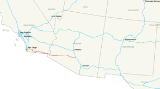
. It runs from the southern edge of Mission Bay at Sunset Cliffs Blvd, in San Diego, California
San Diego, California
San Diego is the eighth-largest city in the United States and second-largest city in California. The city is located on the coast of the Pacific Ocean in Southern California, immediately adjacent to the Mexican border. The birthplace of California, San Diego is known for its mild year-round...
, almost at the Pacific Ocean
Pacific Ocean
The Pacific Ocean is the largest of the Earth's oceanic divisions. It extends from the Arctic in the north to the Southern Ocean in the south, bounded by Asia and Australia in the west, and the Americas in the east.At 165.2 million square kilometres in area, this largest division of the World...
, to the junction with Interstate 10
Interstate 10
Interstate 10 is the fourth-longest Interstate Highway in the United States, after I-90, I-80, and I-40. It is the southernmost east–west, coast-to-coast Interstate Highway, although I-4 and I-8 are further south. It stretches from the Pacific Ocean at State Route 1 in Santa Monica,...
, just southeast of Casa Grande, Arizona
Casa Grande, Arizona
Casa Grande is a city in Pinal County, approximately halfway between Phoenix and Tucson in the U.S. state of Arizona. According to 2010 Census, the population of the city is 48,571...
. In California, especially from eastern San Diego County
San Diego County, California
San Diego County is a large county located in the southwestern corner of the US state of California. Hence, San Diego County is also located in the southwestern corner of the 48 contiguous United States. Its county seat and largest city is San Diego. Its population was about 2,813,835 in the 2000...
to points east, Interstate 8 runs very close to the United States-Mexico border where high-voltage transmission line Path 46
Path 46
Path 46, also called West of Colorado River, Arizona-California West-of-the-River Path , is a set of many alternating current high-voltage transmission lines that are located in southeast California and Nevada up to the Colorado River...
links Southern California to Mexico.