
.gif)
Hurricane Gert (1993)
Encyclopedia
Hurricane Gert was a large tropical cyclone
that caused heavy flood damage and many deaths throughout Central America and Mexico in September 1993. The seventh named storm
and third hurricane of the annual hurricane season
, Gert originated from a tropical wave
over the southwestern Caribbean Sea
on September 14. The following day, the cyclone briefly attained tropical storm strength before it moved ashore in Nicaragua
. It proceeded into Honduras
, and reorganized into a tropical storm over the Gulf of Honduras
before entering Belize
on September 18. After crossing the Yucatán Peninsula
, Gert emerged over warm water in the Bay of Campeche
, and steadily strengthened into a Category 2 hurricane by September 20. With sustained winds of 100 mph (165 km/h), the hurricane made a final landfall
on the Gulf Coast of Mexico
near Tuxpan, Veracruz that same day. The high terrain quickly disrupted its structure, and Gert entered the Pacific near the state of Nayarit
as a tropical depression by September 21. There, it briefly redeveloped a few strong thunderstorms before dissipating over open water five days later.
Gert's broad wind circulation produced widespread and heavy rainfall across Central America. The rain, combined with previously saturated soil from Tropical Storm Bret
, caused significant flooding of property and crops. Although the highest winds from the storm occurred upon landfall in Mexico, the worst effects in the country came from its rains. Following the overflow of several major rivers, deep flood waters submerged extensive parts of Veracruz
and Tamaulipas
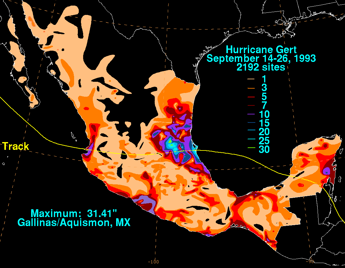
and forced thousands to evacuate. The heaviest rains occurred further inland over the mountainous region of San Luis Potosí
, where as much as 31.41 inches (798 mm) of precipitation were measured. In the wake of the disaster, the road networks across the affected countries were severely disrupted, and thousands of people became homeless. The storm caused at least 92 deaths and over $170 million (1993 USD) in damage.
—or an area of low pressure
oriented north to south—moved off the Africa
n coast well south of Dakar
on September 5 and tracked rapidly westward across the tropical Atlantic. The wave interacted with the Intertropical Convergence Zone
while positioned at a relatively low latitude
, which allowed for the enhancement of convection
in its vicinity. By September 11, a weak surface low had formed along the wave and passed directly over Trinidad
. The majority of the system subsequently moved inland along the northern coast of South America
, though it maintained its identity and emerged over the southwestern Caribbean Sea
on September 13. Owing to favorable tropospheric
conditions aloft, the system began showing signs of development
, as the deep convection organized into well-defined curved rainbands. Based on the increase in organization and the presence of a surface circulation, the National Hurricane Center
(NHC) classified it as a tropical depression at 1800 UTC on September 14, about 105 mi (165 km) north of the northern coast of Panama
.
The depression retained a large circulation during its formative stages, indicated by both satellite observations
and data from rawinsondes in the region. Its cloud pattern continued to coalesce, and the NHC upgraded it to Tropical Storm Gert at 0900 UTC on September 15. After tracking west-northwestward, the center of the storm moved ashore near Bluefields
, Nicaragua
around 1800 UTC that day, with winds
of 40 mph (65 km/h). Interaction with land impeded further development, and Gert weakened back to a tropical depression six hours later. Despite the center being inland for nearly two days, a part of the large circulation stayed over the adjacent Caribbean and Pacific waters. This allowed Gert to remain a tropical cyclone while trekking northwestward through Central America, defying the NHC's repeated forecasts of dissipation over land.
 The cyclone moved into the Gulf of Honduras
on September 17, and subsequently restrengthened into a tropical storm. By that time, it had retraced toward the north-northwest in response to a mid- to upper-level trough over the eastern Gulf of Mexico
. Gert's duration over water was short-lived; the storm moved back inland near Belize City
the next day, allowing minimal opportunity for additional strengthening. Once inland, Gert began to feel the effects of a ridge of high pressure
, and turned back to the west-northwest. After crossing the Yucatán Peninsula
and decreasing in organization, it entered the Bay of Campeche
as a tropical depression late on September 18. Gert restrengthened over open waters as light wind shear
allowed deep convection to consolidate, and by 0600 UTC the next day it once again became a tropical storm. On September 20, data from a United States Air Force aircraft
indicated that the storm had become a hurricane with winds of 75 mph (120 km/h). Its forward motion had slowed slightly due to a shortwave trough
to its north, giving the hurricane more time to organize over water. Upon curving toward the west, Gert attained its peak intensity as a Category 2 hurricane on the Saffir–Simpson scale
, reaching winds of 100 mph (165 km/h).
Around 2100 UTC on September 20, Gert made a final landfall
on the coast of Mexico
at peak intensity, just north of Tuxpan
, Veracruz
. Inland, the hurricane accelerated and rapidly weakened over the mountainous region of the Sierra Madre Oriental
; it had diminished to a tropical depression by September 21. Despite the degeneration, the large circulation remained intact as it crossed the country. Gert entered the Pacific Ocean
near the coast of Nayarit
later that day, where it was reclassified as Tropical Depression Fourteen-E. Although deep convection waxed and waned in intensity, satellite observations indicated the depression could have briefly been a tropical storm on September 22. It continued a west to west-northwestward motion for two days, though low-level flow steered it toward the southwest after the convection diminished. No redevelopment occurred due to cold waters, and the system dissipated on September 26.
issued a green alert for coastal regions on September 14. The next day, a tropical storm warning was also issued for the Atlantic coast of the country. National television and radio stations broadcast warning messages to alert the public, while emergency crews were dispatched in case conditions warranted. This helped with the effective and timely clearing of hospitals, as well as the evacuation of residents in risk zones. A tropical storm warning was also posted for the Atlantic coast of Nicaragua
on September 15, extending south from Puerto Cabezas
and including the adjacent islands. In Honduras
, early warnings allowed several hundred residents to evacuate well ahead of the storm. Once it became evident that Gert would strike the Yucatán Peninsula, coastal areas from Belize
northward to Cozumel, Mexico were placed under a tropical storm warning on September 17 until its landfall the next day.
When Gert was still located over the peninsula, the government of Mexico issued a tropical storm watch for the Gulf Coast from the city of Veracruz
northward to Soto la Marina, Tamaulipas
. By September 18, it was extended southward to Minatitlán
and upgraded to a tropical storm warning, though the initial watch area was placed under a hurricane watch after Gert showed signs of strenghtening. The next day, the watch for the area from Soto La Marina to Nautla was upgraded to hurricane warning as it became clearer where Gert would make landfall. Prior to impact, several ports along the Gulf Coast halted their operations, and people living in risk zones were evacuated. All warnings and watches were discontinued after the hurricane moved inland.
Gert was a large tropical cyclone for most of its lifespan, and it always remained close enough to the coast to restrengthen and redevelop thunderstorms. As a result, the storm produced heavy rains, flooding, and mudslides that killed 92 people from Central America through Mexico. Damage to roads, crop, property, and vegetation surmounted $170 million.
, and are therefore prone to soil saturation. The initial rains caused a significant water rise in many rivers, further exacerbating the flood threat. The imminent overflow of the Tempisque River
prompted a wide-scale evacuation of residents from adjacent areas; however, the river crested gradually without major consequences. Following hours of prolonged downpours, many Pacific regions such as Quepos
, Pérez Zeledón
and Osa
experienced extensive flooding and localized landslides, inflicting heavy damage to roads and some bridges. The floods destroyed about 500 acres (2 km²) of banana crop and caused moderate damage to oil palm
plantations. Small-scale crop farmers of reed
, maize
, beans and rice were also greatly affected. The storm disrupted local fishing, and several small boats in Quepos sustained damage. In addition, high winds caused great destruction to the Manuel Antonio National Park
, which vastly impacted the tourism-driven economy in Quepos.
Gert left considerable property damage in its wake; it demolished 27 homes and damaged 659, mostly due to flooding. In all, monetary losses surmounted $3.1 million, of which over $1.7 million was incurred by damage to the infrastructure. Roughly 1,000 people sought shelter during the storm, but owing to timely preparations only one cardiac arrest fatality was attributable to Gert when a landslide buried a home.
had struck the country, and caused excessive rainfall that continued for days in its wake. In spite of striking the Atlantic coast, Gert produced the largest amounts of precipitation over northern and Pacific coastal areas. A maximum of 17.8 in (452 mm) fell at Corinto
; other high totals include 17.6 in (447 mm) at Chinandega and 17.5 in (444 mm) at León
. The capital of Managua
recorded 9.8 in (249 mm) of rain during the event. Sustained winds from the storm reached no more than 40 mph (65 km/h) upon landfall near Bluefields
, but they generated high waves of up to 12 ft (3.7 m) offshore. After weakening to a depression inland, Gert continued to produce moderate gales along its path through the country.
Off the coast near Big Corn Island
, rough surf and winds destroyed nine fishing boats; two canoes with an unknown number of occupants disappeared at sea. Gert produced significant coastal flooding in Bluefields and Tasbapauni
upon moving ashore, prompting about 1,000 residents and hundreds of indigenous Miskito villagers to evacuate. Further inland, prolonged heavy rains caused numerous rivers to overflow, which in turn led to destructive freshwater flooding. A river near Rama
rose to 32 ft (10 m) above its normal stage, leaving about 80 percent of the town submerged and displacing 3,900 people. Throughout the Boaco Department, similar flooding affected 6,000 residents. Landslides caused additional damage to bridges and roads, disrupting local transportation. At least 252 houses were destroyed and more than 293 experienced damage across 14 of the country's departments. In addition, Gert was responsible for considerable economic losses and damage to infrastructure. It affected 10,408 households to varying degree, and there were 13 confirmed fatalities. Since flood damage from Tropical Storm Bret occurred just a month prior, an exclusive damage total for Gert is unavailable. The two storms inflicted about $10.7 million in damage, primarily to private property.
, at least 6.77 in (172 mm) of rain was recorded. Destructive floods swept through much of northern Honduras, affecting 13 of the country's departments and worsening the impact from Tropical Storm Bret in the Mosquitia Region
one month prior. There, the flooding affected 24,000 people and made communication with surrounding areas nearly impossible. Several major rivers such as the Ulúa River
overflowed due to excessive rains; rivers across Sula Valley sustained heavy damage to their banks, increasing the flood extent. San Pedro Sula
, the country's second-largest city, as well as adjacent municipalities were largely inundated. The rising water prompted the evacuation of many residents, and the Ramón Villeda Morales International Airport
halted all of its operations at the height of the flooding.
The storm greatly devastated Puerto Cortés
, one of the most important port cities in Central America. Elsewhere in Cortés, the overflow of a river in Choloma
triggered widespread floods; landslides in that area alone claimed the lives of six people. The country's agricultural sector sustained heavy flood damage to about 5700 acres (23.1 km²) of plantations across low-lying areas, including banana, sugar and citrus. In all, Gert inflicted $10 million worth of damage to roads, bridges and property. The disaster directly affected 67,447 people, of which roughly 60 percent had to evacuate their homes. In its final public statement, the government of Honduras confirmed 27 fatalities, although another source puts the death toll for the country as high as 103 deaths.
. High winds uprooted several trees or snapped their limbs, damaging power lines and subsequently causing power outages. In one community, heavy downpours triggered damaging mudslides along a major highway. The Río Grande de San Miguel
rapidly crested due to the rains, causing an excess of water discharge just southwest of Usulután
. As a consequence, about 2500 acres (10.1 km²) of crop from adjacent plantations sustained flood damage. Several other areas reported significant losses due to flooding, including San Marcos
and San Vicente
; some property and road damage also occurred in San Miguel
. Fishing operations were suspended during the storm, but four fishermen disappeared at sea. Overall, the weather system affected nearly 8,000 residents; officials reported at least twelve destroyed homes and five deaths in its wake.
Torrential rains from Gert affected around 20,000 people and killed one girl in Guatemala
. The storm caused significant agricultural losses across the country, though there were no other specific reports of damage. Gert moved ashore near Belize City
as a minimal tropical storm, dropping heavy rainfall in Belize. Just offshore, a weather station on Hunting Caye recorded 9.5 in (241 mm) of precipitation during the event. Despite the rains, only minor flooding occurred in Belize City, and there were no fatalities.
as a minimal storm, Gert dropped considerable rainfall in Quintana Roo
; a 24-hour accumulation of 7.4 in (188 mm) was recorded at Chetumal, although much higher localized totals of around 15 in (380 mm) fell elsewhere in the state. Gusty winds briefly buffeted the coast during the storm's landfall, with a maximum wind speed of 44 mph (70 km/h) recorded in Chetumal. Damage was limited to localized floods, however, cutting off one road to traffic. In addition, the flooding forced the inhabitants of some low-lying areas in Chetumal and Felipe Carrillo Puerto
to evacuate to higher ground. Scattered showers caused light flooding in parts of the state of Campeche
, such as Ciudad del Carmen
.
High gales and large waves battered wide stretches of coastline in Tamaulipas
and Veracruz
upon Gert's landfall, although hurricane-force winds were largely confined to the southern eyewall
. Tuxpan, just south of where the eye moved ashore, recorded wind velocities of over 100 mph (160 km/h), while 80 mph (130 km/h) gusts occurred further south in Poza Rica. To the north, winds reached 55 mph (90 km/h) in Tampico, Tamaulipas. Despite the severity of the winds, the worst of Gert occurred due to orographic lift
when its broad circulation made contact with the eastern slopes of the Sierra Madre Oriental highlands. This caused extreme precipitation over large parts of the Huasteca Region
, with 31.41 in (798 mm) of rain recorded in Aquismón
, San Luis Potosí
. In addition, Tempoal in Veracruz recorded a maximum 24-hour total of 13.35 in (339 mm).
The first reports of impact were from high winds, which uprooted trees and ripped off the roofs of homes in Tuxpan, Naranjos
, Cerro Azul
, and Poza Rica. Following Gert's extreme rains, catastrophic flooding struck many northeastern regions. The Pánuco River
rose to its highest level in 40 years and overflowed, forcing thousands of people out of their homes. Continued heavy rain in the wake of the storm aggravated the situation; the flooding ultimately submerged about 2000000 acres (8,093.7 km²) of land around Pánuco
and Tampico. Deep waters and thick mud inundated half of Tampico, demolishing structures and roads and forcing 200,000 residents to evacuate. Urban areas of Madero
and Altamira were also hit hard by the flooding. The Pánuco River basin sustained massive damage to its crops (mainly to coffee, corn, bean, and soy), which increased as the flooding persisted in the following weeks. The agricultural sector in San Luis Potosí also suffered great losses after roughly 80 percent of the crop and large amounts of livestock were washed away. Water damage to schools, bridges, and roads was particularly widespread, and 25 people lost their lives in the state.
Gert's trail of devastation extended as far inland as Hidalgo, where 35 rivers burst their banks. The flooding washed away bridges and roads, isolating 361 communities. It furthermore disrupted the state's power, telephone, and water services, which increased the lack of communication. The storm left fairly significant structural damage in its wake; at least 4,425 homes, 121 schools, and 49 public buildings were affected. Fifteen deaths occurred in the state alone, and eight people suffered injuries. In all, Gert became the worst natural disaster to strike the region in 40 years, with 29,075 houses and 145000 acres (586.8 km²) of crop damaged or destroyed across Mexico. The associated monetary losses totaled $156 million, and the death toll stood at 45.
, which connects the central region to the south of the country, exacerbated the economic losses. Following the extensive flood damage to farmland, many independent crop producers suffered from being unable to partake in subsequent sowing
s.
Prior to the arrival of Gert, a state of emergency was in effect for Nicaragua as a result of Tropical Storm Bret. National and regional relief agencies, including the Red Cross
, consequently extended their relief efforts. Although the government did not specifically reappeal for international assistance, several monetary contributions were made by organizations overseas, and a transfer channel for cash donations was opened at the Swiss Bank Corporation
. The United Nations Development Programme
provided $50,000 for the local purchase of fuel, while UNICEF distributed $25,000 worth of household supplies and medicine. The World Food Programme
donated approximately 160,000 lbs (72 tonne
s) of food supply and offered services of expert in response to the disaster. The federal governments of Japan, Canada, Switzerland, Norway, Germany, and Spain donated a combined $300,000 in aid.
On September 18, the President of Honduras surveyed the affected regions by helicopter; two days later, a local emergency was declared for various municipalities. Although most of the affected population received aid within days, the limited road network caused a large delay in relief efforts to the hard-hit Mosquitia Region. By September 28, about 27,000 residents unable to reenter their flooded homes remained in government-owned shelters. Seven weeks later, a temporary housing project was implemented for the 120 families most in need. Nationwide, sewage systems, water works, and latrines were severely disrupted and in need of rehabilitation. Public health concerns quickly rose in the wake of Gert, with the cost of required medicines totaling $208,000. The governments of Japan, Canada, Germany, and the United Kingdom provided a combined $310,300 for the purchase of relief items. Due to the severity of the disaster, approximately 5,900 families lost their source of income. Following the destruction of its sole water reservoir, much of the Puerto Cortés suffered potable water shortages for months in Gert's wake.
missions were activated. The government appealed for international aid, seeking nutritional and medical supplies, as well as weather-permitting clothing. Five storage centers across Hidalgo provided over 93 million lbs (42,000 tonnes) of food supply; 142,000 lbs (64 tonnes) of chicken, 45,000 pantries, and 76,000 disposable plates were distributed across San Luis Potosí, as well as 50,440 blankets and 6,081 airbeds
. Several schools served as shelters for the homeless; sheltered children, elderly, and pregnant or lactating women received milk powder donations. The cost of the donations totaled $27,000.
Many homes sustained irreparable damage to their roofs, leaving thousands of residents homeless. By three weeks after the storm, over 65,000 people had been accommodated in shelters; most of them remained as such until flood water levels receded weeks later. A grant of $22,000 was made available to purchase roofing sheets for those in urgent need of home repair. The president assigned $37.4 million for the reconstruction of roads and housing, as well as the assistance of affected farmers. In Gert's wake, the amount of respiratory disease and skin infection cases rose slightly, although the overall health situation for the country remained well under control.
Tropical cyclone
A tropical cyclone is a storm system characterized by a large low-pressure center and numerous thunderstorms that produce strong winds and heavy rain. Tropical cyclones strengthen when water evaporated from the ocean is released as the saturated air rises, resulting in condensation of water vapor...
that caused heavy flood damage and many deaths throughout Central America and Mexico in September 1993. The seventh named storm
Tropical cyclone naming
Tropical cyclones have officially been named since 1945 and are named for a variety of reasons, which include to facilitate communications between forecasters and the public when forecasts, watches, and warnings are issued. Names also reduce confusion about what storm is being described, as more...
and third hurricane of the annual hurricane season
1993 Atlantic hurricane season
The 1993 Atlantic hurricane season was a period in the annual formation of tropical cyclones. It officially began on June 1, 1993, and lasted until November 30, 1993. These dates conventionally delimit the period of each year when most tropical cyclones form in the Atlantic basin...
, Gert originated from a tropical wave
Tropical wave
Tropical waves, easterly waves, or tropical easterly waves, also known as African easterly waves in the Atlantic region, are a type of atmospheric trough, an elongated area of relatively low air pressure, oriented north to south, which move from east to west across the tropics causing areas of...
over the southwestern Caribbean Sea
Caribbean Sea
The Caribbean Sea is a sea of the Atlantic Ocean located in the tropics of the Western hemisphere. It is bounded by Mexico and Central America to the west and southwest, to the north by the Greater Antilles, and to the east by the Lesser Antilles....
on September 14. The following day, the cyclone briefly attained tropical storm strength before it moved ashore in Nicaragua
Nicaragua
Nicaragua is the largest country in the Central American American isthmus, bordered by Honduras to the north and Costa Rica to the south. The country is situated between 11 and 14 degrees north of the Equator in the Northern Hemisphere, which places it entirely within the tropics. The Pacific Ocean...
. It proceeded into Honduras
Honduras
Honduras is a republic in Central America. It was previously known as Spanish Honduras to differentiate it from British Honduras, which became the modern-day state of Belize...
, and reorganized into a tropical storm over the Gulf of Honduras
Gulf of Honduras
The Gulf or Bay of Honduras is a large inlet of the Caribbean Sea, indenting the coasts of Belize, Guatemala, and Honduras. From north to south, it runs for approximately 200 km from Dangriga, Belize, to La Ceiba, Honduras....
before entering Belize
Belize
Belize is a constitutional monarchy and the northernmost country in Central America. Belize has a diverse society, comprising many cultures and languages. Even though Kriol and Spanish are spoken among the population, Belize is the only country in Central America where English is the official...
on September 18. After crossing the Yucatán Peninsula
Yucatán Peninsula
The Yucatán Peninsula, in southeastern Mexico, separates the Caribbean Sea from the Gulf of Mexico, with the northern coastline on the Yucatán Channel...
, Gert emerged over warm water in the Bay of Campeche
Bay of Campeche
The Bay of Campeche is the southern bight of the Gulf of Mexico. It is surrounded on three sides by the Mexican states of Campeche, Tabasco and Veracruz. It was named by Francisco Hernández de Córdoba and Antonio de Alaminos during their expedition in 1517...
, and steadily strengthened into a Category 2 hurricane by September 20. With sustained winds of 100 mph (165 km/h), the hurricane made a final landfall
Landfall (meteorology)
Landfall is the event of a tropical cyclone or a waterspout coming onto land after being over water. When a waterspout makes landfall it is reclassified as a tornado, which can then cause damage inland...
on the Gulf Coast of Mexico
Gulf Coast of Mexico
The Gulf Coast of Mexico stretches along the Gulf of Mexico from the border with the United states at Matamoros, Tamaulipas all the way to the tip of the Yucatán Peninsula at Cancún. It includes the coastal regions along the Bay of Campeche. Major cities include Veracruz, Tampico, and...
near Tuxpan, Veracruz that same day. The high terrain quickly disrupted its structure, and Gert entered the Pacific near the state of Nayarit
Nayarit
Nayarit officially Estado Libre y Soberano de Nayarit is one of the 31 states which, with the Federal District, comprise the 32 Federal Entities of Mexico. It is divided in 20 municipalities and its capital city is Tepic.It is located in Western Mexico...
as a tropical depression by September 21. There, it briefly redeveloped a few strong thunderstorms before dissipating over open water five days later.
Gert's broad wind circulation produced widespread and heavy rainfall across Central America. The rain, combined with previously saturated soil from Tropical Storm Bret
Tropical Storm Bret (1993)
Tropical Storm Bret was the second named storm of the 1993 Atlantic hurricane season. The third tropical cyclone of the season, Bret formed on August 4 from a westward moving, African tropical wave. Bret would later peak as a 60 mph tropical storm as it neared Trinidad...
, caused significant flooding of property and crops. Although the highest winds from the storm occurred upon landfall in Mexico, the worst effects in the country came from its rains. Following the overflow of several major rivers, deep flood waters submerged extensive parts of Veracruz
Veracruz
Veracruz, formally Veracruz de Ignacio de la Llave officially Estado Libre y Soberano de Veracruz de Ignacio de la Llave , is one of the 31 states that, along with the Federal District, comprise the 32 federative entities of Mexico. It is divided in 212 municipalities and its capital city is...
and Tamaulipas
Tamaulipas
Tamaulipas officially Estado Libre y Soberano de Tamaulipas is one of the 31 states which, with the Federal District, comprise the 32 Federal Entities of Mexico. It is divided in 43 municipalities and its capital city is Ciudad Victoria. The capital city was named after Guadalupe Victoria, the...
and forced thousands to evacuate. The heaviest rains occurred further inland over the mountainous region of San Luis Potosí
San Luis Potosí
San Luis Potosí officially Estado Libre y Soberano de San Luis Potosí is one of the 31 states which, with the Federal District, comprise the 32 Federal Entities of Mexico. It is divided in 58 municipalities and its capital city is San Luis Potosí....
, where as much as 31.41 inches (798 mm) of precipitation were measured. In the wake of the disaster, the road networks across the affected countries were severely disrupted, and thousands of people became homeless. The storm caused at least 92 deaths and over $170 million (1993 USD) in damage.
Meteorological history
A tropical waveTropical wave
Tropical waves, easterly waves, or tropical easterly waves, also known as African easterly waves in the Atlantic region, are a type of atmospheric trough, an elongated area of relatively low air pressure, oriented north to south, which move from east to west across the tropics causing areas of...
—or an area of low pressure
Trough (meteorology)
A trough is an elongated region of relatively low atmospheric pressure, often associated with fronts.Unlike fronts, there is not a universal symbol for a trough on a weather chart. The weather charts in some countries or regions mark troughs by a line. In the United States, a trough may be marked...
oriented north to south—moved off the Africa
Africa
Africa is the world's second largest and second most populous continent, after Asia. At about 30.2 million km² including adjacent islands, it covers 6% of the Earth's total surface area and 20.4% of the total land area...
n coast well south of Dakar
Dakar
Dakar is the capital city and largest city of Senegal. It is located on the Cap-Vert Peninsula on the Atlantic coast and is the westernmost city on the African mainland...
on September 5 and tracked rapidly westward across the tropical Atlantic. The wave interacted with the Intertropical Convergence Zone
Intertropical Convergence Zone
The Intertropical Convergence Zone , known by sailors as The Doldrums, is the area encircling the earth near the equator where winds originating in the northern and southern hemispheres come together....
while positioned at a relatively low latitude
Latitude
In geography, the latitude of a location on the Earth is the angular distance of that location south or north of the Equator. The latitude is an angle, and is usually measured in degrees . The equator has a latitude of 0°, the North pole has a latitude of 90° north , and the South pole has a...
, which allowed for the enhancement of convection
Atmospheric convection
Atmospheric convection is the result of a parcel-environment instability, or temperature difference, layer in the atmosphere. Different lapse rates within dry and moist air lead to instability. Mixing of air during the day which expands the height of the planetary boundary layer leads to...
in its vicinity. By September 11, a weak surface low had formed along the wave and passed directly over Trinidad
Trinidad
Trinidad is the larger and more populous of the two major islands and numerous landforms which make up the island nation of Trinidad and Tobago. It is the southernmost island in the Caribbean and lies just off the northeastern coast of Venezuela. With an area of it is also the fifth largest in...
. The majority of the system subsequently moved inland along the northern coast of South America
South America
South America is a continent situated in the Western Hemisphere, mostly in the Southern Hemisphere, with a relatively small portion in the Northern Hemisphere. The continent is also considered a subcontinent of the Americas. It is bordered on the west by the Pacific Ocean and on the north and east...
, though it maintained its identity and emerged over the southwestern Caribbean Sea
Caribbean Sea
The Caribbean Sea is a sea of the Atlantic Ocean located in the tropics of the Western hemisphere. It is bounded by Mexico and Central America to the west and southwest, to the north by the Greater Antilles, and to the east by the Lesser Antilles....
on September 13. Owing to favorable tropospheric
Troposphere
The troposphere is the lowest portion of Earth's atmosphere. It contains approximately 80% of the atmosphere's mass and 99% of its water vapor and aerosols....
conditions aloft, the system began showing signs of development
Tropical cyclogenesis
Tropical cyclogenesis is the term that describes the development and strengthening of a tropical cyclone in the atmosphere. The mechanisms through which tropical cyclogenesis occurs are distinctly different from those through which mid-latitude cyclogenesis occurs...
, as the deep convection organized into well-defined curved rainbands. Based on the increase in organization and the presence of a surface circulation, the National Hurricane Center
National Hurricane Center
The National Hurricane Center , located at Florida International University in Miami, Florida, is the division of the National Weather Service responsible for tracking and predicting weather systems within the tropics between the Prime Meridian and the 140th meridian west poleward to the 30th...
(NHC) classified it as a tropical depression at 1800 UTC on September 14, about 105 mi (165 km) north of the northern coast of Panama
Panama
Panama , officially the Republic of Panama , is the southernmost country of Central America. Situated on the isthmus connecting North and South America, it is bordered by Costa Rica to the northwest, Colombia to the southeast, the Caribbean Sea to the north and the Pacific Ocean to the south. The...
.
The depression retained a large circulation during its formative stages, indicated by both satellite observations
Weather satellite
The weather satellite is a type of satellite that is primarily used to monitor the weather and climate of the Earth. Satellites can be either polar orbiting, seeing the same swath of the Earth every 12 hours, or geostationary, hovering over the same spot on Earth by orbiting over the equator while...
and data from rawinsondes in the region. Its cloud pattern continued to coalesce, and the NHC upgraded it to Tropical Storm Gert at 0900 UTC on September 15. After tracking west-northwestward, the center of the storm moved ashore near Bluefields
Bluefields
Bluefields is the capital of the municipality of the same name, and of Región Autónoma del Atlántico Sur in Nicaragua. It was also capital of the former Zelaya Department, which was divided into North and South Atlantic Autonomous Regions...
, Nicaragua
Nicaragua
Nicaragua is the largest country in the Central American American isthmus, bordered by Honduras to the north and Costa Rica to the south. The country is situated between 11 and 14 degrees north of the Equator in the Northern Hemisphere, which places it entirely within the tropics. The Pacific Ocean...
around 1800 UTC that day, with winds
Maximum sustained wind
The maximum sustained winds associated with a tropical cyclone are a common indicator of the intensity of the storm. Within a mature tropical cyclone, they are found within the eyewall at a distance defined as the radius of maximum wind, or RMW. Unlike gusts, the value of these winds are...
of 40 mph (65 km/h). Interaction with land impeded further development, and Gert weakened back to a tropical depression six hours later. Despite the center being inland for nearly two days, a part of the large circulation stayed over the adjacent Caribbean and Pacific waters. This allowed Gert to remain a tropical cyclone while trekking northwestward through Central America, defying the NHC's repeated forecasts of dissipation over land.
Gulf of Honduras
The Gulf or Bay of Honduras is a large inlet of the Caribbean Sea, indenting the coasts of Belize, Guatemala, and Honduras. From north to south, it runs for approximately 200 km from Dangriga, Belize, to La Ceiba, Honduras....
on September 17, and subsequently restrengthened into a tropical storm. By that time, it had retraced toward the north-northwest in response to a mid- to upper-level trough over the eastern Gulf of Mexico
Gulf of Mexico
The Gulf of Mexico is a partially landlocked ocean basin largely surrounded by the North American continent and the island of Cuba. It is bounded on the northeast, north and northwest by the Gulf Coast of the United States, on the southwest and south by Mexico, and on the southeast by Cuba. In...
. Gert's duration over water was short-lived; the storm moved back inland near Belize City
Belize City
Belize City is the largest city in the Central American nation of Belize. Unofficial estimates place the population of Belize City at 70,000 or more. It is located at the mouth of the Belize River on the coast of the Caribbean. The city is the country's principal port and its financial and...
the next day, allowing minimal opportunity for additional strengthening. Once inland, Gert began to feel the effects of a ridge of high pressure
Ridge (meteorology)
A ridge is an elongated region of relatively high atmospheric pressure, the opposite of a trough....
, and turned back to the west-northwest. After crossing the Yucatán Peninsula
Yucatán Peninsula
The Yucatán Peninsula, in southeastern Mexico, separates the Caribbean Sea from the Gulf of Mexico, with the northern coastline on the Yucatán Channel...
and decreasing in organization, it entered the Bay of Campeche
Bay of Campeche
The Bay of Campeche is the southern bight of the Gulf of Mexico. It is surrounded on three sides by the Mexican states of Campeche, Tabasco and Veracruz. It was named by Francisco Hernández de Córdoba and Antonio de Alaminos during their expedition in 1517...
as a tropical depression late on September 18. Gert restrengthened over open waters as light wind shear
Wind shear
Wind shear, sometimes referred to as windshear or wind gradient, is a difference in wind speed and direction over a relatively short distance in the atmosphere...
allowed deep convection to consolidate, and by 0600 UTC the next day it once again became a tropical storm. On September 20, data from a United States Air Force aircraft
Hurricane Hunters
The Hurricane Hunters are aircraft that fly into tropical cyclones in the North Atlantic Ocean and Northeastern Pacific Ocean for the specific purpose of directly measuring weather data in and around those storms. In the United States, the Air Force, Navy, and NOAA units have all participated in...
indicated that the storm had become a hurricane with winds of 75 mph (120 km/h). Its forward motion had slowed slightly due to a shortwave trough
Shortwave (meteorology)
A shortwave or shortwave trough is an embedded kink in the trough / ridge pattern. This is the opposite of longwaves, which are responsible for synoptic scale systems, although shortwaves may be contained within or found ahead of longwaves and range from the mesocale to the synoptic scale...
to its north, giving the hurricane more time to organize over water. Upon curving toward the west, Gert attained its peak intensity as a Category 2 hurricane on the Saffir–Simpson scale
Saffir-Simpson Hurricane Scale
The Saffir–Simpson Hurricane Scale , or the Saffir–Simpson Hurricane Wind Scale , classifies hurricanes — Western Hemisphere tropical cyclones that exceed the intensities of tropical depressions and tropical storms — into five categories distinguished by the intensities of their sustained winds...
, reaching winds of 100 mph (165 km/h).
Around 2100 UTC on September 20, Gert made a final landfall
Landfall (meteorology)
Landfall is the event of a tropical cyclone or a waterspout coming onto land after being over water. When a waterspout makes landfall it is reclassified as a tornado, which can then cause damage inland...
on the coast of Mexico
Mexico
The United Mexican States , commonly known as Mexico , is a federal constitutional republic in North America. It is bordered on the north by the United States; on the south and west by the Pacific Ocean; on the southeast by Guatemala, Belize, and the Caribbean Sea; and on the east by the Gulf of...
at peak intensity, just north of Tuxpan
Tuxpan
Tuxpan is both a municipality and city located in the Mexican state of Veracruz. The population of the city was 78,523 and of the municipality was 134,394 inhabitants, according to the INEGI census of 2005, residing in a total area of 1,051.89 km²...
, Veracruz
Veracruz
Veracruz, formally Veracruz de Ignacio de la Llave officially Estado Libre y Soberano de Veracruz de Ignacio de la Llave , is one of the 31 states that, along with the Federal District, comprise the 32 federative entities of Mexico. It is divided in 212 municipalities and its capital city is...
. Inland, the hurricane accelerated and rapidly weakened over the mountainous region of the Sierra Madre Oriental
Sierra Madre Oriental
The Sierra Madre Oriental is a mountain range in northeastern Mexico.-Setting:Spanning the Sierra Madre Oriental runs from Coahuila south through Nuevo León, southwest Tamaulipas, San Luis Potosí, Querétaro, and Hidalgo to northern Puebla, where it joins with the east-west running Eje Volcánico...
; it had diminished to a tropical depression by September 21. Despite the degeneration, the large circulation remained intact as it crossed the country. Gert entered the Pacific Ocean
Pacific Ocean
The Pacific Ocean is the largest of the Earth's oceanic divisions. It extends from the Arctic in the north to the Southern Ocean in the south, bounded by Asia and Australia in the west, and the Americas in the east.At 165.2 million square kilometres in area, this largest division of the World...
near the coast of Nayarit
Nayarit
Nayarit officially Estado Libre y Soberano de Nayarit is one of the 31 states which, with the Federal District, comprise the 32 Federal Entities of Mexico. It is divided in 20 municipalities and its capital city is Tepic.It is located in Western Mexico...
later that day, where it was reclassified as Tropical Depression Fourteen-E. Although deep convection waxed and waned in intensity, satellite observations indicated the depression could have briefly been a tropical storm on September 22. It continued a west to west-northwestward motion for two days, though low-level flow steered it toward the southwest after the convection diminished. No redevelopment occurred due to cold waters, and the system dissipated on September 26.
Preparations
After confirming the development of a tropical depression, authorities in Costa RicaCosta Rica
Costa Rica , officially the Republic of Costa Rica is a multilingual, multiethnic and multicultural country in Central America, bordered by Nicaragua to the north, Panama to the southeast, the Pacific Ocean to the west and the Caribbean Sea to the east....
issued a green alert for coastal regions on September 14. The next day, a tropical storm warning was also issued for the Atlantic coast of the country. National television and radio stations broadcast warning messages to alert the public, while emergency crews were dispatched in case conditions warranted. This helped with the effective and timely clearing of hospitals, as well as the evacuation of residents in risk zones. A tropical storm warning was also posted for the Atlantic coast of Nicaragua
Nicaragua
Nicaragua is the largest country in the Central American American isthmus, bordered by Honduras to the north and Costa Rica to the south. The country is situated between 11 and 14 degrees north of the Equator in the Northern Hemisphere, which places it entirely within the tropics. The Pacific Ocean...
on September 15, extending south from Puerto Cabezas
Puerto Cabezas
Puerto Cabezas is a municipality in, and capital of, the North Atlantic Coast department of Nicaragua....
and including the adjacent islands. In Honduras
Honduras
Honduras is a republic in Central America. It was previously known as Spanish Honduras to differentiate it from British Honduras, which became the modern-day state of Belize...
, early warnings allowed several hundred residents to evacuate well ahead of the storm. Once it became evident that Gert would strike the Yucatán Peninsula, coastal areas from Belize
Belize
Belize is a constitutional monarchy and the northernmost country in Central America. Belize has a diverse society, comprising many cultures and languages. Even though Kriol and Spanish are spoken among the population, Belize is the only country in Central America where English is the official...
northward to Cozumel, Mexico were placed under a tropical storm warning on September 17 until its landfall the next day.
When Gert was still located over the peninsula, the government of Mexico issued a tropical storm watch for the Gulf Coast from the city of Veracruz
Veracruz, Veracruz
Veracruz, officially known as Heroica Veracruz, is a major port city and municipality on the Gulf of Mexico in the Mexican state of Veracruz. The city is located in the central part of the state. It is located along Federal Highway 140 from the state capital Xalapa, and is the state's most...
northward to Soto la Marina, Tamaulipas
Soto la Marina, Tamaulipas
Soto la Marina is a town in Soto la Marina Municipality located in the Mexican state of Tamaulipas. It was directly hit by Hurricane Alex in 2010.-External links:* Official website...
. By September 18, it was extended southward to Minatitlán
Minatitlán, Veracruz
Minatitlán is a city in southeastern Mexican state of Veracruz in the Olmec region of the state and the north of the Isthmus of Tehuantepec.In 2010 the greater metropolitan area had a population of 356,020...
and upgraded to a tropical storm warning, though the initial watch area was placed under a hurricane watch after Gert showed signs of strenghtening. The next day, the watch for the area from Soto La Marina to Nautla was upgraded to hurricane warning as it became clearer where Gert would make landfall. Prior to impact, several ports along the Gulf Coast halted their operations, and people living in risk zones were evacuated. All warnings and watches were discontinued after the hurricane moved inland.
Impact
| Country | Deaths |
|---|---|
| Honduras Honduras Honduras is a republic in Central America. It was previously known as Spanish Honduras to differentiate it from British Honduras, which became the modern-day state of Belize... |
27 |
| Nicaragua Nicaragua Nicaragua is the largest country in the Central American American isthmus, bordered by Honduras to the north and Costa Rica to the south. The country is situated between 11 and 14 degrees north of the Equator in the Northern Hemisphere, which places it entirely within the tropics. The Pacific Ocean... |
13 |
| El Salvador El Salvador El Salvador or simply Salvador is the smallest and the most densely populated country in Central America. The country's capital city and largest city is San Salvador; Santa Ana and San Miguel are also important cultural and commercial centers in the country and in all of Central America... |
5 |
| Costa Rica Costa Rica Costa Rica , officially the Republic of Costa Rica is a multilingual, multiethnic and multicultural country in Central America, bordered by Nicaragua to the north, Panama to the southeast, the Pacific Ocean to the west and the Caribbean Sea to the east.... |
1 |
| Guatemala Guatemala Guatemala is a country in Central America bordered by Mexico to the north and west, the Pacific Ocean to the southwest, Belize to the northeast, the Caribbean to the east, and Honduras and El Salvador to the southeast... |
1 |
| Mexico Mexico The United Mexican States , commonly known as Mexico , is a federal constitutional republic in North America. It is bordered on the north by the United States; on the south and west by the Pacific Ocean; on the southeast by Guatemala, Belize, and the Caribbean Sea; and on the east by the Gulf of... |
45 |
| Total | 92 |
Gert was a large tropical cyclone for most of its lifespan, and it always remained close enough to the coast to restrengthen and redevelop thunderstorms. As a result, the storm produced heavy rains, flooding, and mudslides that killed 92 people from Central America through Mexico. Damage to roads, crop, property, and vegetation surmounted $170 million.
Costa Rica
Although Gert's center remained off the coast of Costa Rica, its large circulation produced brisk winds and heavy rainfall across the country. A local weather station recorded 13.1 in (332 mm) of rain during the passage of the storm. Geologically, the hardest-hit regions consist of sedi4mentary layers with poor hydraulic conductivityHydraulic conductivity
Hydraulic conductivity, symbolically represented as K, is a property of vascular plants, soil or rock, that describes the ease with which water can move through pore spaces or fractures. It depends on the intrinsic permeability of the material and on the degree of saturation...
, and are therefore prone to soil saturation. The initial rains caused a significant water rise in many rivers, further exacerbating the flood threat. The imminent overflow of the Tempisque River
Tempisque River
The Tempisque River, or Rio Tempisque, is 144 km long, located entirely in Costa Rica flowing from the Guanacaste Cordillera near the Orosí Volcano and emptying into the Gulf of Nicoya...
prompted a wide-scale evacuation of residents from adjacent areas; however, the river crested gradually without major consequences. Following hours of prolonged downpours, many Pacific regions such as Quepos
Quepos
Quepos is a city in Puntarenas Province, Costa Rica. It is served by the Quepos-La Managua airport. It is located at around . It is home to approximately 14,000 people....
, Pérez Zeledón
Pérez Zeledón Canton
Pérez Zeledón is the name of the 19th canton in the province of San José in Costa Rica. The canton covers an area of , making it the seventh largest of the 81 cantons in the country. It has a population of 130,982...
and Osa
Osa Peninsula
The Osa Peninsula is a peninsula located in southwestern Costa Rica, in the Puntarenas Province, on the Pacific Ocean, at . The peninsula was formed geologically by a faulting system that extends north into California....
experienced extensive flooding and localized landslides, inflicting heavy damage to roads and some bridges. The floods destroyed about 500 acres (2 km²) of banana crop and caused moderate damage to oil palm
Oil palm
The oil palms comprise two species of the Arecaceae, or palm family. They are used in commercial agriculture in the production of palm oil. The African Oil Palm Elaeis guineensis is native to West Africa, occurring between Angola and Gambia, while the American Oil Palm Elaeis oleifera is native to...
plantations. Small-scale crop farmers of reed
Reed (plant)
Reed is a generic polyphyletic botanical term used to describe numerous tall, grass-like plants of wet places, which are the namesake vegetation of reed beds...
, maize
Maize
Maize known in many English-speaking countries as corn or mielie/mealie, is a grain domesticated by indigenous peoples in Mesoamerica in prehistoric times. The leafy stalk produces ears which contain seeds called kernels. Though technically a grain, maize kernels are used in cooking as a vegetable...
, beans and rice were also greatly affected. The storm disrupted local fishing, and several small boats in Quepos sustained damage. In addition, high winds caused great destruction to the Manuel Antonio National Park
Manuel Antonio National Park
Manuel Antonio National Park, in Spanish the Parque Nacional Manuel Antonio, is a small National Park in the Central Pacific Conservation Area located on the Pacific coast of Costa Rica, just south of the city of Quepos, Puntarenas, and from the national capital of San José...
, which vastly impacted the tourism-driven economy in Quepos.
Gert left considerable property damage in its wake; it demolished 27 homes and damaged 659, mostly due to flooding. In all, monetary losses surmounted $3.1 million, of which over $1.7 million was incurred by damage to the infrastructure. Roughly 1,000 people sought shelter during the storm, but owing to timely preparations only one cardiac arrest fatality was attributable to Gert when a landslide buried a home.
Nicaragua
The storm struck Nicaragua a month after Tropical Storm BretTropical Storm Bret (1993)
Tropical Storm Bret was the second named storm of the 1993 Atlantic hurricane season. The third tropical cyclone of the season, Bret formed on August 4 from a westward moving, African tropical wave. Bret would later peak as a 60 mph tropical storm as it neared Trinidad...
had struck the country, and caused excessive rainfall that continued for days in its wake. In spite of striking the Atlantic coast, Gert produced the largest amounts of precipitation over northern and Pacific coastal areas. A maximum of 17.8 in (452 mm) fell at Corinto
Corinto, Nicaragua
Corinto is a town of 17,000 on the northwest Pacific coast of Nicaragua in the province of Chinandega. The municipality was founded in 1863 and was named in honour of the Greek city of Corinth.- Economy :...
; other high totals include 17.6 in (447 mm) at Chinandega and 17.5 in (444 mm) at León
León, Nicaragua
León is a department in northwestern Nicaragua . It is also the second largest city in Nicaragua, after Managua. It was founded by the Spaniards as Santiago de los Caballeros de León and rivals Granada, Nicaragua, in the number of historic Spanish colonial homes and churches...
. The capital of Managua
Managua
Managua is the capital city of Nicaragua as well as the department and municipality by the same name. It is the largest city in Nicaragua in terms of population and geographic size. Located on the southwestern shore of Lake Xolotlán or Lake Managua, the city was declared the national capital in...
recorded 9.8 in (249 mm) of rain during the event. Sustained winds from the storm reached no more than 40 mph (65 km/h) upon landfall near Bluefields
Bluefields
Bluefields is the capital of the municipality of the same name, and of Región Autónoma del Atlántico Sur in Nicaragua. It was also capital of the former Zelaya Department, which was divided into North and South Atlantic Autonomous Regions...
, but they generated high waves of up to 12 ft (3.7 m) offshore. After weakening to a depression inland, Gert continued to produce moderate gales along its path through the country.
Off the coast near Big Corn Island
Corn Islands
The Corn Islands are two islands about east off the Caribbean coast of Nicaragua, constituting one of 12 municipalities of the Región Autónoma del Atlántico Sur department...
, rough surf and winds destroyed nine fishing boats; two canoes with an unknown number of occupants disappeared at sea. Gert produced significant coastal flooding in Bluefields and Tasbapauni
Tasbapauni
Tasbapauni is a seacoast hamlet in Nicaragua, forty five miles north of Bluefields. The main ethnic groups are Creole and Miskito.Local residents have made fortunes reselling cocaine bundles which wash ashore after going overboard from Colombian drug runner speedboats. They have nicknamed the...
upon moving ashore, prompting about 1,000 residents and hundreds of indigenous Miskito villagers to evacuate. Further inland, prolonged heavy rains caused numerous rivers to overflow, which in turn led to destructive freshwater flooding. A river near Rama
El Rama
El Rama is a municipality in the Región Autónoma del Atlántico Sur department of Nicaragua. It is along the Escondido River which branches off into three other rivers: the Sumi, Rama, and Escondido. It is home to an important Atlantic/Caribbean port. Its population is approximately 50,000...
rose to 32 ft (10 m) above its normal stage, leaving about 80 percent of the town submerged and displacing 3,900 people. Throughout the Boaco Department, similar flooding affected 6,000 residents. Landslides caused additional damage to bridges and roads, disrupting local transportation. At least 252 houses were destroyed and more than 293 experienced damage across 14 of the country's departments. In addition, Gert was responsible for considerable economic losses and damage to infrastructure. It affected 10,408 households to varying degree, and there were 13 confirmed fatalities. Since flood damage from Tropical Storm Bret occurred just a month prior, an exclusive damage total for Gert is unavailable. The two storms inflicted about $10.7 million in damage, primarily to private property.
Honduras
Although it had weakened to a depression, Gert continued to produce significant rainfall while tracking across Honduras. In TegucigalpaTegucigalpa
Tegucigalpa , and commonly referred as Tegus , is the capital of Honduras and seat of government of the Republic, along with its twin sister Comayagüela. Founded on September 29, 1578 by the Spanish, it became the country's capital on October 30, 1880 under President Marco Aurelio Soto...
, at least 6.77 in (172 mm) of rain was recorded. Destructive floods swept through much of northern Honduras, affecting 13 of the country's departments and worsening the impact from Tropical Storm Bret in the Mosquitia Region
La Mosquitia
La Mosquitia refers to the northeastern part of Honduras along the Mosquito Coast. It is an underdeveloped region of tropical rainforest accessible primarily by water and air. Its population include indigenous groups such as the Miskito, the Pech, Rama, Sumo, and Tawakha. The Río Plátano Biosphere...
one month prior. There, the flooding affected 24,000 people and made communication with surrounding areas nearly impossible. Several major rivers such as the Ulúa River
Ulúa River
The Ulua River is a river in western Honduras. It rises in the central mountainous area of the country close to La Paz and runs 150 miles approximately due northwards to the east end of the Gulf of Honduras at . En route, it is joined by the Sulaco River, the Otoro River and the Chamelecon River....
overflowed due to excessive rains; rivers across Sula Valley sustained heavy damage to their banks, increasing the flood extent. San Pedro Sula
San Pedro Sula
San Pedro Sula is a city in Honduras. It is located in the northwest corner of the country, in the Valle de Sula , about 60 km south of Puerto Cortés on the Caribbean. With an estimated population of 638,259 people in the main municipality, and 802,598 in its metro area , it is the second...
, the country's second-largest city, as well as adjacent municipalities were largely inundated. The rising water prompted the evacuation of many residents, and the Ramón Villeda Morales International Airport
Ramón Villeda Morales International Airport
Ramón Villeda Morales International Airport , also known as La Mesa International Airport, is located from the city of San Pedro Sula, in the Cortés Department in Honduras. The airport is named after Ramón Villeda Morales, who served as President of Honduras from 1957 to 1963.It is the major and...
halted all of its operations at the height of the flooding.
The storm greatly devastated Puerto Cortés
Puerto Cortés
-Geography:It is on the Caribbean Sea coast, north of San Pedro Sula and east of Omoa, at 15.85° N, 87.94° W. It has a natural bay.It is Honduras's main sea port and it is considered the most important seaport in Central America...
, one of the most important port cities in Central America. Elsewhere in Cortés, the overflow of a river in Choloma
Choloma
Choloma is a municipality in the Honduran department of Cortés. The mayor is Polo Crivelli. It is now the third largest city in Honduras.Many factories are stationed in Choloma due to cheap labor which has helped the municipality's economy. As a result of this fast food joints like Pizza Hut,...
triggered widespread floods; landslides in that area alone claimed the lives of six people. The country's agricultural sector sustained heavy flood damage to about 5700 acres (23.1 km²) of plantations across low-lying areas, including banana, sugar and citrus. In all, Gert inflicted $10 million worth of damage to roads, bridges and property. The disaster directly affected 67,447 people, of which roughly 60 percent had to evacuate their homes. In its final public statement, the government of Honduras confirmed 27 fatalities, although another source puts the death toll for the country as high as 103 deaths.
Elsewhere in Central America
While passing through Central America, Gert generated an increase in cloudiness and showers across El SalvadorEl Salvador
El Salvador or simply Salvador is the smallest and the most densely populated country in Central America. The country's capital city and largest city is San Salvador; Santa Ana and San Miguel are also important cultural and commercial centers in the country and in all of Central America...
. High winds uprooted several trees or snapped their limbs, damaging power lines and subsequently causing power outages. In one community, heavy downpours triggered damaging mudslides along a major highway. The Río Grande de San Miguel
Río Grande de San Miguel
Río Grande de San Miguel is a river in southern El Salvador. It empties to the Pacific Ocean in the Usulután Department at ....
rapidly crested due to the rains, causing an excess of water discharge just southwest of Usulután
Usulután
Usulután is the 5th largest city in El Salvador, and capital of the Department of Usulutan in the south-east of El Salvador. As of 2006, it is estimated to have population of 71,636 people.Usulutan rests in a rich agricultural valley....
. As a consequence, about 2500 acres (10.1 km²) of crop from adjacent plantations sustained flood damage. Several other areas reported significant losses due to flooding, including San Marcos
San Marcos, El Salvador
San Marcos, a city of El Salvador. It is located on a small valley, 5 miles southern San Salvador downtown. Its population is 63,209 inhabitants...
and San Vicente
San Vicente, El Salvador
San Vicente is a municipality in the San Vicente department of El Salvador. It was founded by 50 Spanish families in 1635, under the Tempisque tree, which is still standing today....
; some property and road damage also occurred in San Miguel
San Miguel, El Salvador
San Miguel is the fourth most populous city in El Salvador after Santa Ana and Soyapango and the second most important after San Salvador. It is located 138 km east of the capital, San Salvador. It is also the capital of the department of San Miguel and a municipality...
. Fishing operations were suspended during the storm, but four fishermen disappeared at sea. Overall, the weather system affected nearly 8,000 residents; officials reported at least twelve destroyed homes and five deaths in its wake.
Torrential rains from Gert affected around 20,000 people and killed one girl in Guatemala
Guatemala
Guatemala is a country in Central America bordered by Mexico to the north and west, the Pacific Ocean to the southwest, Belize to the northeast, the Caribbean to the east, and Honduras and El Salvador to the southeast...
. The storm caused significant agricultural losses across the country, though there were no other specific reports of damage. Gert moved ashore near Belize City
Belize City
Belize City is the largest city in the Central American nation of Belize. Unofficial estimates place the population of Belize City at 70,000 or more. It is located at the mouth of the Belize River on the coast of the Caribbean. The city is the country's principal port and its financial and...
as a minimal tropical storm, dropping heavy rainfall in Belize. Just offshore, a weather station on Hunting Caye recorded 9.5 in (241 mm) of precipitation during the event. Despite the rains, only minor flooding occurred in Belize City, and there were no fatalities.
Mexico
While crossing the Yucatán PeninsulaYucatán Peninsula
The Yucatán Peninsula, in southeastern Mexico, separates the Caribbean Sea from the Gulf of Mexico, with the northern coastline on the Yucatán Channel...
as a minimal storm, Gert dropped considerable rainfall in Quintana Roo
Quintana Roo
Quintana Roo officially Estado Libre y Soberano de Quintana Roo is one of the 31 states which, with the Federal District, comprise the 32 Federal Entities of Mexico. It is divided in 10 municipalities and its capital city is Chetumal....
; a 24-hour accumulation of 7.4 in (188 mm) was recorded at Chetumal, although much higher localized totals of around 15 in (380 mm) fell elsewhere in the state. Gusty winds briefly buffeted the coast during the storm's landfall, with a maximum wind speed of 44 mph (70 km/h) recorded in Chetumal. Damage was limited to localized floods, however, cutting off one road to traffic. In addition, the flooding forced the inhabitants of some low-lying areas in Chetumal and Felipe Carrillo Puerto
Felipe Carrillo Puerto, Quintana Roo
See also Felipe Carrillo Puerto, Oaxaca, for the town in Oaxaca.Felipe Carrillo Puerto or simply Carrillo Puerto is the name of a municipality for which the city of the same name serves its the municipal seat. The municipality is located south-central part of the Mexican state of Quintana Roo. It...
to evacuate to higher ground. Scattered showers caused light flooding in parts of the state of Campeche
Campeche
Campeche is one of the 31 states which, with the Federal District, comprise the 32 Federal Entities of Mexico. Located in Southeast Mexico, it is bordered by the states of Yucatán to the north east, Quintana Roo to the east, and Tabasco to the south west...
, such as Ciudad del Carmen
Ciudad del Carmen
Ciudad del Carmen is a city in the southwest of the Mexican state of Campeche. Ciudad del Carmen is located at on the southwest of Carmen Island, which stands in the Laguna de Términos on the coast of the Gulf of Mexico. The 2005 census population was 154,197 people...
.
High gales and large waves battered wide stretches of coastline in Tamaulipas
Tamaulipas
Tamaulipas officially Estado Libre y Soberano de Tamaulipas is one of the 31 states which, with the Federal District, comprise the 32 Federal Entities of Mexico. It is divided in 43 municipalities and its capital city is Ciudad Victoria. The capital city was named after Guadalupe Victoria, the...
and Veracruz
Veracruz
Veracruz, formally Veracruz de Ignacio de la Llave officially Estado Libre y Soberano de Veracruz de Ignacio de la Llave , is one of the 31 states that, along with the Federal District, comprise the 32 federative entities of Mexico. It is divided in 212 municipalities and its capital city is...
upon Gert's landfall, although hurricane-force winds were largely confined to the southern eyewall
Eye (cyclone)
The eye is a region of mostly calm weather found at the center of strong tropical cyclones. The eye of a storm is a roughly circular area and typically 30–65 km in diameter. It is surrounded by the eyewall, a ring of towering thunderstorms where the second most severe weather of a cyclone...
. Tuxpan, just south of where the eye moved ashore, recorded wind velocities of over 100 mph (160 km/h), while 80 mph (130 km/h) gusts occurred further south in Poza Rica. To the north, winds reached 55 mph (90 km/h) in Tampico, Tamaulipas. Despite the severity of the winds, the worst of Gert occurred due to orographic lift
Orographic lift
Orographic lift occurs when an air mass is forced from a low elevation to a higher elevation as it moves over rising terrain. As the air mass gains altitude it quickly cools down adiabatically, which can raise the relative humidity to 100% and create clouds and, under the right conditions,...
when its broad circulation made contact with the eastern slopes of the Sierra Madre Oriental highlands. This caused extreme precipitation over large parts of the Huasteca Region
La Huasteca
La Huasteca is the first climbing area in Monterrey, Mexico, only 15 minutes from the city. With nearly 200 bolted routes with grades from 5.8 to 5.13C, it is the favorite place for weekend climbers. It is also known for the slippery type of limestone from which it is comprised, and which makes...
, with 31.41 in (798 mm) of rain recorded in Aquismón
Aquismón
Aquismón is a town and municipality in San Luis Potosí in central Mexico.-References:...
, San Luis Potosí
San Luis Potosí
San Luis Potosí officially Estado Libre y Soberano de San Luis Potosí is one of the 31 states which, with the Federal District, comprise the 32 Federal Entities of Mexico. It is divided in 58 municipalities and its capital city is San Luis Potosí....
. In addition, Tempoal in Veracruz recorded a maximum 24-hour total of 13.35 in (339 mm).
The first reports of impact were from high winds, which uprooted trees and ripped off the roofs of homes in Tuxpan, Naranjos
Naranjos Amatlán
Naranjos Amatlán is a municipality in Veracruz, Mexico. It is located in north zone of the State of Veracruz, about 402 km from state capital Xalapa. It has an area of...
, Cerro Azul
Cerro Azul, Veracruz
Cerro Azul is a city in the Mexican state of Veracruz. Located in the state's Huasteca Baja region, it serves as the municipal seat for the surrounding municipality of the same name.In the 2005 INEGI Census, the city reported a total population of23,573....
, and Poza Rica. Following Gert's extreme rains, catastrophic flooding struck many northeastern regions. The Pánuco River
Pánuco River
The Pánuco River is a river in Mexico that flows from the River Moctezuma in the Valley of Mexico to the Gulf of Mexico.At its source, it serves as a channel for water-drainage for Mexico City. From there, it becomes the state border between Hidalgo and Querétaro as it moves towards San Luis...
rose to its highest level in 40 years and overflowed, forcing thousands of people out of their homes. Continued heavy rain in the wake of the storm aggravated the situation; the flooding ultimately submerged about 2000000 acres (8,093.7 km²) of land around Pánuco
Pánuco, Veracruz
Pánuco is a city in the Mexican state of Veracruz, located in the state's Huasteca Alta region. It serves as the municipal seat of the surrounding Pánuco Municipality...
and Tampico. Deep waters and thick mud inundated half of Tampico, demolishing structures and roads and forcing 200,000 residents to evacuate. Urban areas of Madero
Ciudad Madero
Madero, formally Ciudad Madero, is a city and its coextensive municipality in the state of Tamaulipas, Mexico. The city is located at 22.27°N, 97.83°W in the extreme southeastern part of the state, on the Gulf of Mexico, just north and east of Tampico but still on the banks of the Río Pánuco, and...
and Altamira were also hit hard by the flooding. The Pánuco River basin sustained massive damage to its crops (mainly to coffee, corn, bean, and soy), which increased as the flooding persisted in the following weeks. The agricultural sector in San Luis Potosí also suffered great losses after roughly 80 percent of the crop and large amounts of livestock were washed away. Water damage to schools, bridges, and roads was particularly widespread, and 25 people lost their lives in the state.
Gert's trail of devastation extended as far inland as Hidalgo, where 35 rivers burst their banks. The flooding washed away bridges and roads, isolating 361 communities. It furthermore disrupted the state's power, telephone, and water services, which increased the lack of communication. The storm left fairly significant structural damage in its wake; at least 4,425 homes, 121 schools, and 49 public buildings were affected. Fifteen deaths occurred in the state alone, and eight people suffered injuries. In all, Gert became the worst natural disaster to strike the region in 40 years, with 29,075 houses and 145000 acres (586.8 km²) of crop damaged or destroyed across Mexico. The associated monetary losses totaled $156 million, and the death toll stood at 45.
Central America
Due to the effects of Gert, the government of Costa Rica declared a national emergency for the country on September 16, 1993. Emergency crews were accordingly dispatched to assess damage and distribute life supplies to the affected population; this included 90,940 lbs (41,250 kg) of food, 1,422 mattresses, and 1,350 blankets. In its wake, the disrupted road network across the affected regions impacted the local agriculture, tourism, and commerce. The obstruction of the major Pan-American HighwayPan-American Highway (North America)
The Pan-American Highway route in North America is the portion of a network of roads nearly 48,000 km in length which travels through the mainland nations of the Americas.No definitive length of the Pan American Highway exists because the U.S...
, which connects the central region to the south of the country, exacerbated the economic losses. Following the extensive flood damage to farmland, many independent crop producers suffered from being unable to partake in subsequent sowing
Sowing
Sowing is the process of planting seeds.-Plants which are usually sown:Among the major field crops, oats, wheat, and rye are sowed, grasses and legumes are seeded, and maize and soybeans are planted...
s.
Prior to the arrival of Gert, a state of emergency was in effect for Nicaragua as a result of Tropical Storm Bret. National and regional relief agencies, including the Red Cross
Nicaraguan Red Cross
The Nicaraguan Red Cross , is a member of the Red Cross Society and the national ambulance service in Nicaragua. Founded on January 10, 1934, it remains the country's emergency medical response organization. The Nicaraguan Red Cross has its headquarters in Managua....
, consequently extended their relief efforts. Although the government did not specifically reappeal for international assistance, several monetary contributions were made by organizations overseas, and a transfer channel for cash donations was opened at the Swiss Bank Corporation
Swiss Bank Corporation
Swiss Bank Corporation was a large integrated financial services company located in Switzerland...
. The United Nations Development Programme
United Nations Development Programme
The United Nations Development Programme is the United Nations' global development network. It advocates for change and connects countries to knowledge, experience and resources to help people build a better life. UNDP operates in 177 countries, working with nations on their own solutions to...
provided $50,000 for the local purchase of fuel, while UNICEF distributed $25,000 worth of household supplies and medicine. The World Food Programme
World Food Programme
The World Food Programme is the food aid branch of the United Nations, and the world's largest humanitarian organization addressing hunger worldwide. WFP provides food, on average, to 90 million people per year, 58 million of whom are children...
donated approximately 160,000 lbs (72 tonne
Tonne
The tonne, known as the metric ton in the US , often put pleonastically as "metric tonne" to avoid confusion with ton, is a metric system unit of mass equal to 1000 kilograms. The tonne is not an International System of Units unit, but is accepted for use with the SI...
s) of food supply and offered services of expert in response to the disaster. The federal governments of Japan, Canada, Switzerland, Norway, Germany, and Spain donated a combined $300,000 in aid.
On September 18, the President of Honduras surveyed the affected regions by helicopter; two days later, a local emergency was declared for various municipalities. Although most of the affected population received aid within days, the limited road network caused a large delay in relief efforts to the hard-hit Mosquitia Region. By September 28, about 27,000 residents unable to reenter their flooded homes remained in government-owned shelters. Seven weeks later, a temporary housing project was implemented for the 120 families most in need. Nationwide, sewage systems, water works, and latrines were severely disrupted and in need of rehabilitation. Public health concerns quickly rose in the wake of Gert, with the cost of required medicines totaling $208,000. The governments of Japan, Canada, Germany, and the United Kingdom provided a combined $310,300 for the purchase of relief items. Due to the severity of the disaster, approximately 5,900 families lost their source of income. Following the destruction of its sole water reservoir, much of the Puerto Cortés suffered potable water shortages for months in Gert's wake.
Mexico
In response to the flood disaster, Red Cross officials immediately began distributing aid to victims. After the President of Mexico assessed the situation by helicopter, the Pánuco River basin was declared an emergency zone, and ground and air-sea search and rescueSearch and rescue
Search and rescue is the search for and provision of aid to people who are in distress or imminent danger.The general field of search and rescue includes many specialty sub-fields, mostly based upon terrain considerations...
missions were activated. The government appealed for international aid, seeking nutritional and medical supplies, as well as weather-permitting clothing. Five storage centers across Hidalgo provided over 93 million lbs (42,000 tonnes) of food supply; 142,000 lbs (64 tonnes) of chicken, 45,000 pantries, and 76,000 disposable plates were distributed across San Luis Potosí, as well as 50,440 blankets and 6,081 airbeds
Air mattress
An air mattress is an inflatable mattress/sleeping pad. Due to its buoyancy, it is also often used as a water toy/flotation device, and in UK is termed as a lilo .-For sleeping:...
. Several schools served as shelters for the homeless; sheltered children, elderly, and pregnant or lactating women received milk powder donations. The cost of the donations totaled $27,000.
Many homes sustained irreparable damage to their roofs, leaving thousands of residents homeless. By three weeks after the storm, over 65,000 people had been accommodated in shelters; most of them remained as such until flood water levels receded weeks later. A grant of $22,000 was made available to purchase roofing sheets for those in urgent need of home repair. The president assigned $37.4 million for the reconstruction of roads and housing, as well as the assistance of affected farmers. In Gert's wake, the amount of respiratory disease and skin infection cases rose slightly, although the overall health situation for the country remained well under control.
See also
- Tropical Storm Arlene (1993)Tropical Storm Arlene (1993)Tropical Storm Arlene was the first tropical cyclone to make landfall in Texas since Hurricane Jerry in 1989. The second tropical cyclone and first named storm of the 1993 Atlantic hurricane season, Arlene developed from a tropical wave in the southern Gulf of Mexico on June 18...
- Tropical Storm Bret (1993)Tropical Storm Bret (1993)Tropical Storm Bret was the second named storm of the 1993 Atlantic hurricane season. The third tropical cyclone of the season, Bret formed on August 4 from a westward moving, African tropical wave. Bret would later peak as a 60 mph tropical storm as it neared Trinidad...
- Other storms of the same nameHurricane GertThe name Gert has been used for four tropical cyclones in the Atlantic Ocean.* 1981's Hurricane Gert - caused heavy rainfall to several Caribbean islands but no significant damage.*...
External links
- The NHC's archive on Hurricane Gert
- The NHC's reports on Hurricane Gert and Tropical Depression Fourteen-E
- The HPCHydrometeorological Prediction CenterThe Hydrometeorological Prediction Center is one of nine service centers under the umbrella of the National Centers for Environmental Prediction , a part of the National Weather Service, which in turn is part of the National Oceanic and Atmospheric Administration of the U.S. government...
's rainfall report on Hurricane Gert and Tropical Depression Fourteen-E - The 1993 Monthly Weather Review