
Maribyrnong river
Encyclopedia
Melbourne
Melbourne is the capital and most populous city in the state of Victoria, and the second most populous city in Australia. The Melbourne City Centre is the hub of the greater metropolitan area and the Census statistical division—of which "Melbourne" is the common name. As of June 2009, the greater...
, Victoria (Australia)
Victoria (Australia)
Victoria is the second most populous state in Australia. Geographically the smallest mainland state, Victoria is bordered by New South Wales, South Australia, and Tasmania on Boundary Islet to the north, west and south respectively....
, near Mount Macedon
Mount Macedon, Victoria
Mount Macedon is a small town located northwest of Melbourne in the Australian state of Victoria. It is situated on the side of the mountain of the same name, known as Geboor by the indigenous Wurundjeri people, which rises to above sea level. At the 2006 census, Mount Macedon had a population...
. It flows generally southward and combines with the Yarra River
Yarra River
The Yarra River, originally Birrarung, is a river in east-central Victoria, Australia. The lower stretches of the river is where the city of Melbourne was established in 1835 and today Greater Melbourne dominates and influences the landscape of its lower reaches...
to flow into Port Phillip
Port Phillip
Port Phillip Port Phillip Port Phillip (also commonly referred to as Port Phillip Bay or (locally) just The Bay, is a large bay in southern Victoria, Australia; it is the location of Melbourne. Geographically, the bay covers and the shore stretches roughly . Although it is extremely shallow for...
.
The inner western and north-western suburbs of Melbourne are located in the vicinity of the Maribyrnong River and the river has given its name to the suburb of Maribyrnong
Maribyrnong, Victoria
Maribyrnong is a suburb 8 km north-west of Melbourne, Victoria, Australia. Its Local Government Area is the City of Maribyrnong, part of River Ward. At the 2006 Census, Maribyrnong had a population of 8242....
and the local government area, the City of Maribyrnong
City of Maribyrnong
The City of Maribyrnong is a Local Government Area located within the metropolitan area of Melbourne, Victoria, Australia. It comprises the inner western suburbs between 5 and 10 kilometres from the Melbourne city centre...
.
Etymology
The river was initially named Saltwater River by early settlers, due to the tidal nature of its lower reaches. The name Maribyrnong however, is derived from either mirring-gnay-bir-nong which in WoiwurrungWoiwurrung
Woiwurrung is an Indigenous Australian language spoken by some of the Kulin Nation clans, the Wurundjeri people, of Central Victoria, from Mount Baw Baw in the east to Mount Macedon, Sunbury and Gisborne in the west.The Woiwurrung clans inhabited the Yarra River, called Birrarung in Woiwurrung,...
, the language of the local Wurundjeri
Wurundjeri
The Wurundjeri are a people of the Indigenous Australian nation of the Woiwurrung language group, in the Kulin alliance, who occupy the Birrarung Valley, its tributaries and the present location of Melbourne, Australia...
people, is said to mean "I can hear a ringtail possum" or "saltwater river" (Gunung or Gunnung is Woiwurrung for river, as seen in the names of other watercourses in the area, such as; Koonung Creek
Koonung Creek
Koonung Creek is a small tributary of the Yarra River in Melbourne's east. The creek originates in Nunawading near Springvale Road, and flows to join the Yarra at the border between Ivanhoe East, Bulleen and Balwyn North. The place the two waterways meet forms the borders between these suburbs...
and Birrarung
Yarra River
The Yarra River, originally Birrarung, is a river in east-central Victoria, Australia. The lower stretches of the river is where the city of Melbourne was established in 1835 and today Greater Melbourne dominates and influences the landscape of its lower reaches...
).
Marriburnong is an alternate spelling listed on a map dated from 1840.
History
The Maribyrnong River valley has been home for the WurundjeriWurundjeri
The Wurundjeri are a people of the Indigenous Australian nation of the Woiwurrung language group, in the Kulin alliance, who occupy the Birrarung Valley, its tributaries and the present location of Melbourne, Australia...
people of the Kulin
Kulin
The Kulin nation, was an alliance of five Indigenous Australian nations in Central Victoria, Australia, prior to European settlement. Their collective territory extended to around Port Phillip and Western Port, up into the Great Dividing Range and the Loddon and Goulburn River valleys. To their...
nation for up to 40,000 years. Human remains dated at least 15,000 years old have been found along the river, with much older signs of human habitation also present.
The first Europeans to explore along the river were the party led by Charles Grimes
Charles Grimes
Charles Grimes was an English-born surveyor who did some valuable work in colonial Australia. He served as surveyor-general of New South Wales and discovered the Yarra River in what is now the state of Victoria. He is perhaps best known for being the surveyor who mapped the route of the Hobart...
, Deputy Surveyor-General of New South Wales
New South Wales
New South Wales is a state of :Australia, located in the east of the country. It is bordered by Queensland, Victoria and South Australia to the north, south and west respectively. To the east, the state is bordered by the Tasman Sea, which forms part of the Pacific Ocean. New South Wales...
, in February 1803. John Batman
John Batman
John Batman was an Australian grazier, businessman and explorer who is best known for his role in the founding of a settlement which became Melbourne and the colony of Victoria.-Life:...
is likely to have explored up the river in early 1835. With the establishment of the colony of Melbourne
History of Melbourne
The history of Melbourne details the city's growth from a fledging settlement into a modern commercial and financial centre as Australia's second largest city.-Pre-European settlement:...
later that year, sheep runs were soon established by Edmund Davis Fergusson and Michael Solomon in the Avondale and Sunshine areas. On Solomon's sheep station the ford now near the west end of Canning Street in Avondale Heights
Avondale Heights, Victoria
Avondale Heights is a suburb 12 km north-west of Melbourne, Victoria, Australia. Its Local Government Area is the City of Moonee Valley. At the 2006 Census, Avondale Heights had a population of 11,074....
soon became known as Solomon's Ford. This was the lowest crossing on the Saltwater (Maribyrnong) River, and the furthest inland point of tidal influence. Batman is believed to have crossed the river at this point probably in the well worn steps of Aboriginals. It was for many years the only way from Melbourne to Geelong and land west.
During the second half of the nineteenth century much of Melbourne's industry was located along the river, and the water became very degraded. With the closure of many industries since the 1960s and 1970s, much river front land has opened up to parkland and highly sought after residential estates.
Geography
The geographic features and tributaries of the river are listed below, tributaries in bold:- Yarra RiverYarra RiverThe Yarra River, originally Birrarung, is a river in east-central Victoria, Australia. The lower stretches of the river is where the city of Melbourne was established in 1835 and today Greater Melbourne dominates and influences the landscape of its lower reaches...
, of which the Maribyrnong River is a tributaryTributaryA tributary or affluent is a stream or river that flows into a main stem river or a lake. A tributary does not flow directly into a sea or ocean... - Yarraville Wharves
- Maribyrnong Berth
- Newells Paddock Wetlands
- Burndap Lakes
- Jacks Canal
- Frogs Hollow Wetland
- Cliffs
- Steele or Rose Creek
- Grimes Flat
- Kulin Wetlands
- Taylors Creek
- Horseshoe Bend
- Gumms Corner
- Unnamed Creek
- Jackson Creek / Deep CreekDeep Creek (Victoria)Deep Creek is a watercourse in the Yarra-Maribyrnong catchment area, north of Melbourne in Victoria, which arises from the confluence of a number of smaller streams draining the north eastern slopes of the Mount Macedon range and the southern slopes of the Cobaw range, both ranges being...
Headwaters
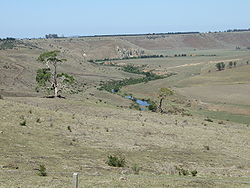
Jackson Creek starts its journey NW of Gisborne
Gisborne, Victoria
Gisborne is a town located approximately northwest of Melbourne, Victoria, Australia. As it is close to Melbourne, but in attractive countryside, it is proving an increasingly popular place to settle. The town was named after Henry Fyshe Gisborne , the first Commissioner for Crown Lands of the...
, 50 km north of Melbourne.
The other major tributary of the Maribyrnong is Deep Creek
Deep Creek (Victoria)
Deep Creek is a watercourse in the Yarra-Maribyrnong catchment area, north of Melbourne in Victoria, which arises from the confluence of a number of smaller streams draining the north eastern slopes of the Mount Macedon range and the southern slopes of the Cobaw range, both ranges being...
, which also has its headwaters in the northern and eastern parts of the Macedon Ranges. The creek has cut a deep valley through the surrounding basalt
Basalt
Basalt is a common extrusive volcanic rock. It is usually grey to black and fine-grained due to rapid cooling of lava at the surface of a planet. It may be porphyritic containing larger crystals in a fine matrix, or vesicular, or frothy scoria. Unweathered basalt is black or grey...
plains in its southward course, in particular as it flows through localities such as Konagaderra and Bulla
Bulla, Victoria
Bulla is a locality and township in Melbourne, Victoria, Australia, north-west from Melbourne's central business district. It is adjacent to the Melbourne metropolitan area. Its Local Government Area is the City of Hume...
.
To the west of Melbourne Airport
Melbourne Airport
Melbourne Airport , also known as Tullamarine Airport, is the primary airport serving the city of Melbourne and the second busiest in Australia. It was opened in 1970 to replace the nearby Essendon Airport. Melbourne Airport is the sole international airport of the four airports serving the...
the tributaries of Jackson Creek and Deep Creek
Deep Creek (Victoria)
Deep Creek is a watercourse in the Yarra-Maribyrnong catchment area, north of Melbourne in Victoria, which arises from the confluence of a number of smaller streams draining the north eastern slopes of the Mount Macedon range and the southern slopes of the Cobaw range, both ranges being...
conjoin to form the Maribyrnong River. The Organ Pipes National Park
Organ Pipes National Park
The Organ Pipes National Park , a protected area, is located in Victoria, Australia. It was established with the focus on conservation of the native flora and fauna, and preservation of the geological features in the Jackson Creek, a part of the Maribyrnong valley, north-west of Melbourne...
can be found on Jacksons Creek, near the Calder Freeway
Calder Freeway
Calder Freeway is a freeway linking Melbourne to Ravenswood South in Victoria, Australia, superseding stretches of the Calder Highway. Originally just a short spur of the Tullamarine Freeway linking to the Calder Highway in Keilor in suburban Melbourne, it has been extended in phases to Ravenswood...
: a pleasant picnic site, and a unique display of basaltic columns a geological formation so named because they look like organ pipes.
Middle reaches
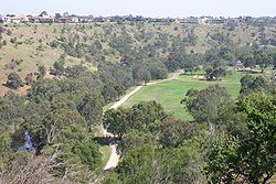
Keilor, Victoria
Keilor is a suburb in Melbourne, Victoria, Australia, 18 km north-west from Melbourne's central business district. Its Local Government Area are the Cities of Brimbank and Hume...
the river winds back on itself in a giant horsehoe bend, before winding south again at Brimbank Park. Here the river flows fifty five metres below the western plains. Horseshoe Bend Farm is a small scale farm open to schools, kindergartens, playgroups and the general public.
Brimbank Park forms a huge amphitheatre in the bend in the river with picnic areas, cycle and walking trails, and a cafe, which reverberate with activity on weekends and public holidays. The area is rich in birdlife and native fauna.
The Maribyrnong River Trail
Maribyrnong River Trail
The Maribyrnong River Trail is a shared use path for cyclists and pedestrians, which follows the Maribyrnong River through the north western suburbs of Melbourne, Victoria, Australia....
shared path starts at Brimbank Park, following mostly beside the river to near its conjunction with the Yarra River
Yarra River
The Yarra River, originally Birrarung, is a river in east-central Victoria, Australia. The lower stretches of the river is where the city of Melbourne was established in 1835 and today Greater Melbourne dominates and influences the landscape of its lower reaches...
in Footscray
Footscray, Victoria
Footscray is a suburb 5 km west of Melbourne, Victoria, Australia. Its Local Government Area is the City of Maribyrnong. At the 2006 Census, Footscray had a population of 11,401....
.
At Avondale Heights
Avondale Heights, Victoria
Avondale Heights is a suburb 12 km north-west of Melbourne, Victoria, Australia. Its Local Government Area is the City of Moonee Valley. At the 2006 Census, Avondale Heights had a population of 11,074....
and Essendon West
Essendon West, Victoria
Essendon West is a suburb in Melbourne, Victoria, Australia, 11 km north-west from Melbourne's central business district. Its Local Government Area is the City of Moonee Valley...
residents have a spectacular view over the river valley to the skyscraper
Skyscraper
A skyscraper is a tall, continuously habitable building of many stories, often designed for office and commercial use. There is no official definition or height above which a building may be classified as a skyscraper...
s of the Melbourne CBD.
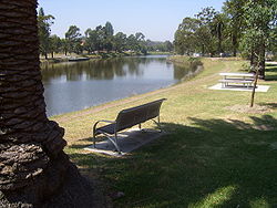
Lower reaches
The river flows past Pipemakers Park at MaribyrnongMaribyrnong, Victoria
Maribyrnong is a suburb 8 km north-west of Melbourne, Victoria, Australia. Its Local Government Area is the City of Maribyrnong, part of River Ward. At the 2006 Census, Maribyrnong had a population of 8242....
and the Living Museum of the West which presents information on the history of the river and the early industrial history of the site.
Dolphins are sometimes sighted in the lower reaches of the river, along with many water birds, especially at Burndap Park.
Footscray Park
Footscray Park
Footscray Park is one of the largest and most intact examples of an Edwardian park in Australia. The 15 hectare park is located on the south bank of the Maribyrnong River in Footscray in Victoria...
opposite the Flemington Racecourse
Flemington Racecourse
Flemington Racecourse is a major horse racing venue located in Melbourne, Victoria, Australia. It is most notable for hosting the Melbourne Cup, which is Australia's richest horse race. The racecourse is situated on low alluvial flats, next to the Maribyrnong River...
is only metres down river from Pipemakers Park and Burndap Park, the river then meanders across the floodplain to its juncture with the Yarra River
Yarra River
The Yarra River, originally Birrarung, is a river in east-central Victoria, Australia. The lower stretches of the river is where the city of Melbourne was established in 1835 and today Greater Melbourne dominates and influences the landscape of its lower reaches...
at Yarraville
Yarraville, Victoria
Yarraville is a suburb 6 km west of Melbourne, Victoria, Australia. Its Local Government Area is the City of Maribyrnong. At the 2006 Census, Yarraville had a population of 12,726....
.
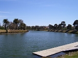
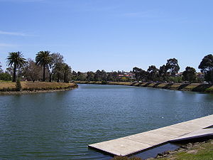
Recreational use
As the second major river in metropolitan Melbourne, the Maribyrnong plays a very important part in Melbourne's recreation. BoatingBoating
Boating is the leisurely activity of travelling by boat, or the recreational use of a boat whether powerboats, sailboats, or man-powered vessels , focused on the travel itself, as well as sports activities, such as fishing or water skiing...
, cycling
Cycling
Cycling, also called bicycling or biking, is the use of bicycles for transport, recreation, or for sport. Persons engaged in cycling are cyclists or bicyclists...
along its bike paths such as the Maribyrnong River Trail
Maribyrnong River Trail
The Maribyrnong River Trail is a shared use path for cyclists and pedestrians, which follows the Maribyrnong River through the north western suburbs of Melbourne, Victoria, Australia....
, fishing
Fishing
Fishing is the activity of trying to catch wild fish. Fish are normally caught in the wild. Techniques for catching fish include hand gathering, spearing, netting, angling and trapping....
, and walking
Walking
Walking is one of the main gaits of locomotion among legged animals, and is typically slower than running and other gaits. Walking is defined by an 'inverted pendulum' gait in which the body vaults over the stiff limb or limbs with each step...
. Light bushwalking can also be done and nature watchers can observe Australian native fauna such as echidna
Echidna
Echidnas , also known as spiny anteaters, belong to the family Tachyglossidae in the monotreme order of egg-laying mammals. There are four extant species, which, together with the platypus, are the only surviving members of that order and are the only extant mammals that lay eggs...
, wallabies
Wallaby
A wallaby is any of about thirty species of macropod . It is an informal designation generally used for any macropod that is smaller than a kangaroo or wallaroo that has not been given some other name.-Overview:...
as well as the ubiquitous possums
Common Brushtail Possum
The Common Brushtail Possum is a nocturnal, semi-arboreal marsupial of the family Phalangeridae, it is native to Australia, and the largest of the possums.Like most possums, the Common Brushtail is nocturnal...
and flying foxes
Pteropus
Bats of the genus Pteropus, belonging to the megabat or Megachiroptera sub-order, are the largest bats in the world. They are commonly known as the fruit bats or flying foxes among other colloquial names...
.
Crossings
Road and rail bridges and other crossing points along the Maribyrnong River include:- Shepherd Bridge - primary arterial road
- South Kensington-West Footscray railway
- Hopetoun Bridge - primary arterial road
- Suburban railway to Footscray
- Former stock bridge - relocated from Punt Road, South Yarra
- Lynchs Bridge - primary arterial road
- Farnsworth Avenue Bridge - secondary arterial road
- Pipemakers Park Footbridge
- Maribyrnong RoadMaribyrnong RoadMaribyrnong Road is a major road in northwestern Melbourne, Australia. It forms the boundary between the suburbs of Moonee Ponds and Ascot Vale for its entire length. The road is used frequently by trucks, and also has a tram line...
Bridge - primary arterial road - Afton Street Footbridge - pedestrian
- Canning Street Bridge - primary arterial road
- Medway Golf Club Footbridge
- Solomons Ford - historic crossing point
- Maribyrnong River Viaduct, on the Albion-Jacana railway
- E.J. Whitten Bridge - Western Ring Road
- Ford
- Ford
- Old Calder HighwayCalder HighwayCalder Highway is a Highway linking Ravenswood South in Victoria, to Mildura. North of the Victoria/New South Wales border, the highway continues north to Broken Hill, Tibooburra and the New South Wales/Queensland border as the Silver City Highway, under the standard national route shield as far...
Bridge - primary arterial road - Historic Calder Bridge (1868)
- Calder FreewayCalder FreewayCalder Freeway is a freeway linking Melbourne to Ravenswood South in Victoria, Australia, superseding stretches of the Calder Highway. Originally just a short spur of the Tullamarine Freeway linking to the Calder Highway in Keilor in suburban Melbourne, it has been extended in phases to Ravenswood...
Bridge - Flora Street Bridge - local road and private access
- Historic Arundel Road Bridge - (built 1906-7, closed to vehicles 1989, closed to pedestrians 2007)
- Arundel Road Bridge (1989) - local road
Flora and fauna
Native species
Many native species exist along the Maribyrnong River with many species thriving in the area.Native mammals / marsupials
Swamp WallabySwamp Wallaby
The Swamp Wallaby is a small macropod marsupial of eastern Australia. This wallaby is also commonly known as the Black Wallaby, with other names including Black-tailed Wallaby, Fern Wallaby, Black Pademelon, Stinker , and Black Stinker...
, Grey-headed Flying Foxes or Fruit Bats, Common Brushtail Possum
Common Brushtail Possum
The Common Brushtail Possum is a nocturnal, semi-arboreal marsupial of the family Phalangeridae, it is native to Australia, and the largest of the possums.Like most possums, the Common Brushtail is nocturnal...
, Common Ringtail Possum
Common Ringtail Possum
The common ringtail possum is an Australian marsupial. It lives in a variety of habitats and eats a variety of leaves of both native and introduced plants, as well as flowers and fruits. These dietary factors have, over time, aided burgeoning introduced populations in New Zealand...
, Water Rat or Rakali, Echidna
Echidna
Echidnas , also known as spiny anteaters, belong to the family Tachyglossidae in the monotreme order of egg-laying mammals. There are four extant species, which, together with the platypus, are the only surviving members of that order and are the only extant mammals that lay eggs...
, Platypus
Platypus
The platypus is a semi-aquatic mammal endemic to eastern Australia, including Tasmania. Together with the four species of echidna, it is one of the five extant species of monotremes, the only mammals that lay eggs instead of giving birth to live young...
- up river only
Native reptiles
Eastern Brown SnakeEastern brown snake
The eastern brown snake , often referred to as the common brown snake, is a species of genus Pseudonaja. This snake is considered the second most venomous land snake based on its value in mice. It is native to Australia, New Guinea and Indonesia.-Description:Adult eastern brown snakes are highly...
, Tiger Snake, Skinks, Common snakeneck turtle
Common snakeneck turtle
The eastern long-necked turtle , also known as the eastern snake-necked turtle, common snake-necked turtle or common long-necked turtle, has as its most distinctive feature its extremely long neck. In some cases, this turtle's neck can be as long as its carapace...
Native birds
Eastern WhipbirdEastern Whipbird
The Eastern Whipbird is an insectivorous passerine bird native to the east coast of Australia, its whip-crack call a familiar sound in forests of eastern Australia. Two subspecies are recognised. Heard much more often than seen, it is a dark olive-green and black in colour with a distinctive white...
, Cockatoo
Cockatoo
A cockatoo is any of the 21 species belonging to the bird family Cacatuidae. Along with the Psittacidae and the Strigopidae , they make up the parrot order Psittaciformes . Placement of the cockatoos as a separate family is fairly undisputed, although many aspects of the other living lineages of...
, Rainbow Lorikeet
Rainbow Lorikeet
The Rainbow Lorikeet, is a species of Australasian parrot found in Australia, eastern Indonesia , Papua New Guinea, New Caledonia, Solomon Islands and Vanuatu. In Australia, it is common along the eastern seaboard, from Queensland to South Australia and northwest Tasmania...
, Galah
Galah
The Galah , Eolophus roseicapilla, also known as the Rose-breasted Cockatoo, Galah Cockatoo, Roseate Cockatoo or Pink and Grey, is one of the most common and widespread cockatoos, and it can be found in open country in almost all parts of mainland Australia.It is endemic on the mainland and was...
, Brown Falcon
Brown Falcon
The Brown Falcon , also known as the Brown Hawk, is a member of the falcon genus found in the drier regions of Australia. Its specific name berigora is derived from an aboriginal name for the bird....
, Peregrine Falcon
Peregrine Falcon
The Peregrine Falcon , also known as the Peregrine, and historically as the Duck Hawk in North America, is a widespread bird of prey in the family Falconidae. A large, crow-sized falcon, it has a blue-gray back, barred white underparts, and a black head and "moustache"...
, Square-tailed Kite
Square-tailed Kite
The Square-tailed Kite is a bird of prey in the family Accipitridae which also includes many other diurnal raptors such as kites, eagles and harriers.-Conservation status:...
, Royal Spoonbill
Royal Spoonbill
The Royal Spoonbill, Platalea regia, also known as the Black-billed Spoonbill, occurs in intertidal flats and shallows of fresh and saltwater wetlands in Australia, New Zealand, Indonesia, Papua New Guinea, and the Solomon Islands. It has also been recorded as a vagrant in New Caledonia...
, Black Swan
Black Swan
The Black Swan is a large waterbird, a species of swan, which breeds mainly in the southeast and southwest regions of Australia. The species was hunted to extinction in New Zealand, but later reintroduced. Within Australia they are nomadic, with erratic migration patterns dependent upon climatic...
, Pacific Black Duck
Pacific Black Duck
The Pacific Black Duck is a dabbling duck found in much of Indonesia, New Guinea, Australia, New Zealand, and many islands in the southwestern Pacific, reaching to the Caroline Islands in the north and French Polynesia in the east. It is usually called the Grey Duck in New Zealand...
, Little Pied Cormorant
Little Pied Cormorant
The Little Pied Cormorant, Little Shag or Kawaupaka is a common Australasian waterbird, found around the coasts, islands, estuaries, and inland waters of Australia, New Guinea, New Zealand, Malaysia, and Indonesia, and around the islands of the south-western Pacific and the sub-Antarctic...
, Moorhen
Moorhen
Moorhens, sometimes called marsh hens, are medium-sized water birds that are members of the rail family Rallidae. They constitute the genus Gallinula....
, Long-billed Corella
Long-billed Corella
The Long-billed Corella, Cacatua tenuirostris, is a cockatoo native to Australia, which is similar in appearance to the Little Corella and Sulphur-crested Cockatoo. This species is mostly white, with a reddish-pink face and forehead, and has a long pale beak, which is used to dig for roots and seeds...
Native fish
- Short-finned EelShort-finned eelThe short-finned eel, Anguilla australis, is one of the 15 species of eel in the family Anguillidae. It is native to the lakes, dams and coastal rivers of south-eastern Australia, New Zealand, and much of the South Pacific, including New Caledonia, Norfolk Island, Lord Howe Island, Tahiti, and...
, Tupong, Short-headed Lamprey, Australian GraylingAustralian graylingThe Australian grayling is a primarily freshwater fish found in coastal rivers in Tasmania and south-eastern Australia. In past decades it has also been known as the “cucumber mullet” or “cucumber herring,” for its cucumber-like odor.-Description and Diet:The Australian grayling is a streamlined...
, Common GalaxiasCommon galaxiasThe common galaxias or the inanga , is a species of fish from the galaxiid family that is very widespread in the southern hemisphere. It is a slim narrow fish with a forked tail and as an adult it lives in freshwater rivers and lakes. Common galaxias grows to a length of 40 to 120 mm, but can grow...
, Broad-finned galaxies and Spotted galaxiasSpotted galaxias-Introduction:Spotted galaxias are a largish, primarily-freshwater galaxias species found in southern Australia. Spotted galaxias are perhaps the most beautiful of the Australian galaxias species...
, Southern black breamSouthern black breamThe southern black bream, Acanthopagrus butcheri, is a species of marine and freshwater fish of the porgy family, Sparidae...
etc.
Other native species
starfish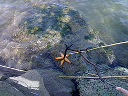
Introduced birds
Song ThrushSong Thrush
The Song Thrush is a thrush that breeds across much of Eurasia. It is also known in English dialects as throstle or mavis. It has brown upperparts and black-spotted cream or buff underparts and has three recognised subspecies...
, Common Blackbird, Common Myna
Common Myna
The Common Myna or Indian Myna also sometimes spelled Mynah, is a member of family Sturnidae native to Asia. An omnivorous open woodland bird with a strong territorial instinct, the Myna has adapted extremely well to urban environments...
, Common Starling, House Sparrow
House Sparrow
The House Sparrow is a bird of the sparrow family Passeridae, found in most parts of the world. One of about 25 species in the genus Passer, the House Sparrow occurs naturally in most of Europe, the Mediterranean region, and much of Asia...
, Spotted Turtle Dove, Rock Pigeon
Rock Pigeon
The Rock Dove or Rock Pigeon, is a member of the bird family Columbidae . In common usage, this bird is often simply referred to as the "pigeon"....
, Mallard
Mallard
The Mallard , or Wild Duck , is a dabbling duck which breeds throughout the temperate and subtropical Americas, Europe, Asia, and North Africa, and has been introduced to New Zealand and Australia....
Social Divider
For a long time, Melbourne's western suburbs have suffered the stigma of disadvantage. According to Campbell Rose from The AgeThe Age
The Age is a daily broadsheet newspaper, which has been published in Melbourne, Australia since 1854. Owned and published by Fairfax Media, The Age primarily serves Victoria, but is also available for purchase in Tasmania, the Australian Capital Territory and border regions of South Australia and...
, this perception of the west as a rust belt bedevilled by social and economic malaise hasn't been helped by the inevitable comparisons to the east — the affluent, leafy suburbs with iconic schools and institutions, with the Maribyrnong River acting as some sort of physical, mental, social and economic divide.
See also
- Maribyrnong River TrailMaribyrnong River TrailThe Maribyrnong River Trail is a shared use path for cyclists and pedestrians, which follows the Maribyrnong River through the north western suburbs of Melbourne, Victoria, Australia....
- Afton Street Conservation ReserveAfton Street Conservation ReserveThe Afton Street Conservation Reserve is located along the middle reaches of the Maribyrnong river in West Essendon, Melbourne. It is within the City of Moonee Valley and is 17 hectares .- History :...
- Kororoit CreekKororoit CreekKororoit Creek is a major waterway of over 80 km in length in the north-west and western parts of Melbourne. Its headwaters are north of Sunbury at 400m above sea level in ordovician geology...
another major watercourse in Melbourne's west. - Deep Creek (Victoria)Deep Creek (Victoria)Deep Creek is a watercourse in the Yarra-Maribyrnong catchment area, north of Melbourne in Victoria, which arises from the confluence of a number of smaller streams draining the north eastern slopes of the Mount Macedon range and the southern slopes of the Cobaw range, both ranges being...
- Jacksons Creek (Victoria)Jacksons Creek (Victoria)Jacksons Creek is a watercourse in the Yarra-Maribyrnong catchment area, north of Melbourne in Victoria, which arises from the confluence of a number of smaller streams draining the southern slopes of the Mount Macedon range being part of the Great Dividing Range.Jacksons Creek flows generally...