

CityLink
Encyclopedia
CityLink is a system of tolled
urban Highway
s in Melbourne
, Victoria
, Australia
. The company Transurban
was awarded the contract to augment two existing freeways and construct two new Toll roads—labelled the Western and Southern Links—directly linking a number of existing freeways to provide a continuous, high-capacity road route to, and around, the central business district.
. The plan advocated for reservations and set aside sinking funds for the new inner city freeway system. It was one of the few freeways connecting to the inner city (along with the Eastern Freeway to Clifton Hill) which was not later canned.
The proposal to build CityLink was first announced in May 1992 and received the State Government's formal approval in mid-1994. The contract was awarded to Transurban, a partnership between Australia's Transfield Services
and Japan's Obayashi Corporation in 1995. The total value of the project was estimated in 1996 at about $1.8 billion, and the 34 year concession
to operate the road expires in 2035.
CityLink was built between 1996 and 2000 and was eight times larger any other road project in Melbourne to that time. Toll plazas for manual tolling were impractical, and delays associated with plaza operations would have decreased the advantages of using the new road. The decision to use only electronic toll collection
was made in 1992, when there was no real field experience in the field. The first of the sections opened to traffic in August 1999, with tolling commencing on 3 January 2000 before final completion occurred on 28 December 2000 with tolling commencing the same year.
The Exhibition Street Extension
was not part of the initial project, as the project had been promoted as a bypass that would keep cars out of the CBD. Under a contract announced in April 1998, Transurban would operate the road and collect tolls from road users, with the road being opened in October 1999.
CityLink saw the widening and upgrading of the inner sections of the Tullamarine and Monash Freeways, as well tolls being imposed, which attracted criticism from road users.
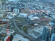 The elevated Western Link extends the existing Tullamarine Freeway, lengthening it to terminate it five kilometres further south at the West Gate Freeway in Port Melbourne. It includes a new major bridge (the Bolte Bridge
, named after former Premier
Sir Henry Bolte
) over the Yarra River
in the Docklands
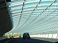
; and a tube-like sound barrier in Flemington
where the road passes close to a number of community housing towers. A short distance to the north of the sound tube, a massive sculptural work was placed, called the Melbourne International Gateway, consisting of a giant yellow beam hanging diagonally across the road (nicknamed the "Cheesestick") and a row of smaller red beams alongside the road (the "Zipper", or "rack of lamb"). The Tullamarine Freeway was also widended from Bell Street to Flemington Road, with a transit lane being added in each direction.
This section of Freeway was originally designated in the 1969 Melbourne Transportation Plan
as part of the F14 Freeway Corridor.
and Domain
Tunnels which pass under the Royal Botanic Gardens
and the Yarra River, each tunnel channelling traffic in different directions. This link also includes a connection to the CBD from the Monash Freeway over a bridge extension of Exhibition Street
over the nearby railway
lines.
This section of Freeway was shown in the 1969 Melbourne Transportation Plan as part of the F9 Freeway corridor as a surface-level road.
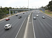 There are no toll booths along the entire length of the system, so traffic flow is not impeded.
CityLink uses a DSRC toll system called e-TAG
, where an electronic transponder is mounted on the inside of the vehicles' windscreen. Gantries constructed over each carriageway record registration plates and detect the e-TAGs, and deduct toll amounts automatically from the account linked electronically to each tag. Where a tag is not detected, the vehicle's registration is recorded using an automatic number plate recognition
system and checked against a database. For infrequent use of the system one can buy a Daypass – by phone, online, at any Australia Post
outlet or at participating service stations. A Daypass can be bought in advance or afterwards (until midnight three days later). The vehicle's registered owner will be sent a late toll invoice fine in the mail if payment is not made, and if the late toll invoice is then not paid a fine will be issued by civic compliance victoria.
The system came under fire in 2003 when it was found that e-TAGs did not warn drivers when their batteries were running low, and non-functioning batteries caused vehicles not to be detected by the toll sensors, thereby attracting additional charges and fines. CityLink has since recognised that e-TAGs have a limited lifespan and have undertaken a campaign to raise awareness among customers to contact them should their e-TAG not beep.
Note
Exits are numbered at the interchange only.
Toll road
A toll road is a privately or publicly built road for which a driver pays a toll for use. Structures for which tolls are charged include toll bridges and toll tunnels. Non-toll roads are financed using other sources of revenue, most typically fuel tax or general tax funds...
urban Highway
Highway
A highway is any public road. In American English, the term is common and almost always designates major roads. In British English, the term designates any road open to the public. Any interconnected set of highways can be variously referred to as a "highway system", a "highway network", or a...
s in Melbourne
Melbourne
Melbourne is the capital and most populous city in the state of Victoria, and the second most populous city in Australia. The Melbourne City Centre is the hub of the greater metropolitan area and the Census statistical division—of which "Melbourne" is the common name. As of June 2009, the greater...
, Victoria
Victoria (Australia)
Victoria is the second most populous state in Australia. Geographically the smallest mainland state, Victoria is bordered by New South Wales, South Australia, and Tasmania on Boundary Islet to the north, west and south respectively....
, Australia
Australia
Australia , officially the Commonwealth of Australia, is a country in the Southern Hemisphere comprising the mainland of the Australian continent, the island of Tasmania, and numerous smaller islands in the Indian and Pacific Oceans. It is the world's sixth-largest country by total area...
. The company Transurban
Transurban
Transurban is an international toll road developer and manager with interests in Australia and North America. In Australia, Transurban has a stake in five out of Sydney’s nine motorways, and in Melbourne it is the full owner of CityLink, which connects three of the city’s major freeways...
was awarded the contract to augment two existing freeways and construct two new Toll roads—labelled the Western and Southern Links—directly linking a number of existing freeways to provide a continuous, high-capacity road route to, and around, the central business district.
History
The first mention of a Southern and Western inner city bypass was in the 1969 Melbourne Transportation Plan1969 Melbourne Transportation Plan
The 1969 Melbourne Transportation Plan was a road and rail transport plan for Melbourne, the state capital of Victoria, Australia instituted by Henry Bolte's state government...
. The plan advocated for reservations and set aside sinking funds for the new inner city freeway system. It was one of the few freeways connecting to the inner city (along with the Eastern Freeway to Clifton Hill) which was not later canned.
The proposal to build CityLink was first announced in May 1992 and received the State Government's formal approval in mid-1994. The contract was awarded to Transurban, a partnership between Australia's Transfield Services
Transfield Services
Transfield Services Limited is an Australian publicly listed corporation providing operations and maintenance, asset management, project and capital management outsourcing and infrastructure development services to the resources and industrial, infrastructure services and property and facilities...
and Japan's Obayashi Corporation in 1995. The total value of the project was estimated in 1996 at about $1.8 billion, and the 34 year concession
Concession (contract)
A concession is a business operated under a contract or license associated with a degree of exclusivity in business within a certain geographical area. For example, sports arenas or public parks may have concession stands. Many department stores contain numerous concessions operated by other...
to operate the road expires in 2035.
CityLink was built between 1996 and 2000 and was eight times larger any other road project in Melbourne to that time. Toll plazas for manual tolling were impractical, and delays associated with plaza operations would have decreased the advantages of using the new road. The decision to use only electronic toll collection
Electronic toll collection
Electronic toll collection , an adaptation of military "identification friend or foe" technology, aims to eliminate the delay on toll roads by collecting tolls electronically. It is thus a technological implementation of a road pricing concept...
was made in 1992, when there was no real field experience in the field. The first of the sections opened to traffic in August 1999, with tolling commencing on 3 January 2000 before final completion occurred on 28 December 2000 with tolling commencing the same year.
The Exhibition Street Extension
Exhibition Street, Melbourne
Exhibition Street is a major street in the central business district of Melbourne, Australia. The street is named after the World Heritage listed Royal Exhibition Building, which is located in the Carlton Gardens.- Geography :...
was not part of the initial project, as the project had been promoted as a bypass that would keep cars out of the CBD. Under a contract announced in April 1998, Transurban would operate the road and collect tolls from road users, with the road being opened in October 1999.
Existing freeways
Previously, the city centre was served by four separate freeways:- The Monash FreewayMonash FreewayMonash Freeway is an urban freeway in Victoria, Australia linking Melbourne's CBD to its southeastern suburbs and the Gippsland region. The entire stretch of the Monash Freeway bears the designation...
(also previously known as the South Eastern Freeway, South Eastern Arterial, and Mulgrave Freeway in different sections of the existing route) which had begun approximately 2 km south-east of the city, and connects Melbourne to the outlying rural GippslandGippslandGippsland is a large rural region in Victoria, Australia. It begins immediately east of the suburbs of Melbourne and stretches to the New South Wales border, lying between the Great Dividing Range to the north and Bass Strait to the south...
area; - The
 /
/ Tullamarine FreewayTullamarine FreewayThe Tullamarine Freeway is an urban freeway in Melbourne, Australia, linking Melbourne Airport to the central business district.-History:Tullamarine Freeway is one of the oldest freeways in Melbourne, originally constructed in 1968-1970...
which had begun approximately 5 km north-west of the city, and links Melbourne to Tullamarine AirportMelbourne AirportMelbourne Airport , also known as Tullamarine Airport, is the primary airport serving the city of Melbourne and the second busiest in Australia. It was opened in 1970 to replace the nearby Essendon Airport. Melbourne Airport is the sole international airport of the four airports serving the...
, and also joins the Calder FreewayCalder FreewayCalder Freeway is a freeway linking Melbourne to Ravenswood South in Victoria, Australia, superseding stretches of the Calder Highway. Originally just a short spur of the Tullamarine Freeway linking to the Calder Highway in Keilor in suburban Melbourne, it has been extended in phases to Ravenswood...
, which links Melbourne to Bendigo; - The West Gate FreewayWest Gate FreewayWest Gate Freeway is a freeway in Melbourne, Australia, linking Geelong to Melbourne CBD and beyond. It is also a link between Melbourne and the west and linking industrial and residential areas west of the Yarra River with the city and port areas. The iconic West Gate Bridge is a part of the...
(also previously known as the Lower Yarra Freeway) which had begun near Port Melbourne, just southwest of the city, crossing the Yarra River using the West Gate BridgeWest Gate BridgeThe West Gate Bridge is a steel box girder cable-stayed bridge in Melbourne, Victoria, Australia. It spans the Yarra River, just north of its mouth into Port Phillip, and is a vital link between the inner city and Melbourne's western suburbs with the industrial suburbs in the west and with the city...
and joins to both the Princes FreewayPrinces FreewayThe Princes Freeway is a , 2 section freeway, which links Melbourne to Geelong on the west and Morwell on the east . It continues beyond these extremities as the Princes Highway towards Adelaide to the west and Sydney to the east...
(linking to Geelong) and the Western Ring Road;
 - The
 Eastern Freeway which begins near CollingwoodCollingwood, VictoriaCollingwood is an inner city suburb of Melbourne, Victoria, Australia, 3 km north-east from Melbourne's central business district. Its Local Government Area is the City of Yarra...
, passing through Melbourne's eastern and north-eastern suburbSuburbThe word suburb mostly refers to a residential area, either existing as part of a city or as a separate residential community within commuting distance of a city . Some suburbs have a degree of administrative autonomy, and most have lower population density than inner city neighborhoods...
s.
CityLink saw the widening and upgrading of the inner sections of the Tullamarine and Monash Freeways, as well tolls being imposed, which attracted criticism from road users.
Western Link
Bolte Bridge
The Bolte Bridge is a large twin Cantilever bridge in Melbourne, Victoria, Australia. It spans the Yarra River and Victoria Harbour in the Docklands precinct to the west of the Melbourne CBD...
, named after former Premier
Premiers of Victoria
The Premier of Victoria is the leader of the government in the Australian state of Victoria. The Premier is appointed by the Governor of Victoria, and is the leader of the political party able to secure a majority in the Legislative Assembly....
Sir Henry Bolte
Henry Bolte
Sir Henry Edward Bolte GCMG was an Australian politician. He was the 38th and longest serving Premier of Victoria.- Early years :...
) over the Yarra River
Yarra River
The Yarra River, originally Birrarung, is a river in east-central Victoria, Australia. The lower stretches of the river is where the city of Melbourne was established in 1835 and today Greater Melbourne dominates and influences the landscape of its lower reaches...
in the Docklands
Melbourne Docklands
Docklands is an inner city suburb in Melbourne, Victoria, Australia occupying an area extending up to 2 km west of and adjacent to Melbourne's Central Business District . Its Local Government Area is the City of Melbourne...
; and a tube-like sound barrier in Flemington
Flemington, Victoria
Flemington is a suburb in Melbourne, Victoria, Australia, situated between the Maribyrnong River and Moonee Ponds Creek 4 km north-west from Melbourne's central business district. It was named by settler James Watson after Flemington estate in Scotland. Its Local Government Areas are the...
where the road passes close to a number of community housing towers. A short distance to the north of the sound tube, a massive sculptural work was placed, called the Melbourne International Gateway, consisting of a giant yellow beam hanging diagonally across the road (nicknamed the "Cheesestick") and a row of smaller red beams alongside the road (the "Zipper", or "rack of lamb"). The Tullamarine Freeway was also widended from Bell Street to Flemington Road, with a transit lane being added in each direction.
This section of Freeway was originally designated in the 1969 Melbourne Transportation Plan
1969 Melbourne Transportation Plan
The 1969 Melbourne Transportation Plan was a road and rail transport plan for Melbourne, the state capital of Victoria, Australia instituted by Henry Bolte's state government...
as part of the F14 Freeway Corridor.
Southern Link
The underground Southern Link directly connects the ends of the West Gate and Monash Freeways into one continuous through-way. This link comprises the BurnleyBurnley Tunnel
The Burnley Tunnel is a tollway tunnel in Melbourne, in Victoria, Australia, which carries traffic eastbound from the West Gate Freeway to the Monash Freeway. It is part of the CityLink Tollway operated by Transurban. Running under the Yarra River and the inner suburbs of Richmond and Burnley, the...
and Domain
Domain Tunnel
The Domain Tunnel is a road tunnel located in Melbourne, Australia, which carries traffic westbound from the Monash Freeway to the West Gate Freeway, running under the Yarra River and Kings Domain...
Tunnels which pass under the Royal Botanic Gardens
Royal Botanic Gardens, Melbourne
The Royal Botanic Gardens Melbourne are internationally renowned botanical gardens located near the centre of Melbourne, Victoria, Australia, on the south bank of the Yarra River. They are 38 hectares of landscaped gardens consisting of a mix of native and non-native vegetation including over...
and the Yarra River, each tunnel channelling traffic in different directions. This link also includes a connection to the CBD from the Monash Freeway over a bridge extension of Exhibition Street
Exhibition Street, Melbourne
Exhibition Street is a major street in the central business district of Melbourne, Australia. The street is named after the World Heritage listed Royal Exhibition Building, which is located in the Carlton Gardens.- Geography :...
over the nearby railway
Rail transport
Rail transport is a means of conveyance of passengers and goods by way of wheeled vehicles running on rail tracks. In contrast to road transport, where vehicles merely run on a prepared surface, rail vehicles are also directionally guided by the tracks they run on...
lines.
This section of Freeway was shown in the 1969 Melbourne Transportation Plan as part of the F9 Freeway corridor as a surface-level road.
Tolling system
CityLink uses a DSRC toll system called e-TAG
E-TAG
e-TAG is an electronic toll collection system used on tollways throughout Australia. Based upon the DSRC protocol, it was originally developed by Transurban for use on their CityLink tollway in the early 1990s, with the system since adopted by all electronic tolled roads, bridges and tunnels in...
, where an electronic transponder is mounted on the inside of the vehicles' windscreen. Gantries constructed over each carriageway record registration plates and detect the e-TAGs, and deduct toll amounts automatically from the account linked electronically to each tag. Where a tag is not detected, the vehicle's registration is recorded using an automatic number plate recognition
Automatic number plate recognition
Automatic number plate recognition is a mass surveillance method that uses optical character recognition on images to read the license plates on vehicles. They can use existing closed-circuit television or road-rule enforcement cameras, or ones specifically designed for the task...
system and checked against a database. For infrequent use of the system one can buy a Daypass – by phone, online, at any Australia Post
Australia Post
Australia Post is the trading name of the Australian Government-owned Australian Postal Corporation .-History:...
outlet or at participating service stations. A Daypass can be bought in advance or afterwards (until midnight three days later). The vehicle's registered owner will be sent a late toll invoice fine in the mail if payment is not made, and if the late toll invoice is then not paid a fine will be issued by civic compliance victoria.
The system came under fire in 2003 when it was found that e-TAGs did not warn drivers when their batteries were running low, and non-functioning batteries caused vehicles not to be detected by the toll sensors, thereby attracting additional charges and fines. CityLink has since recognised that e-TAGs have a limited lifespan and have undertaken a campaign to raise awareness among customers to contact them should their e-TAG not beep.
Controversies
- As part of the development of CityLink, existing roads were upgraded and expanded, and tolling points were added. Toll charges now apply to the Monash Freeway (between Toorak Road and Punt Road) and the Tullamarine Freeway (south of Bulla Road). These roads did not cost tolls to use before.
- Some nearby roads were altered to restrict rat runs to stop people using neighbourhood back streets as short cuts to avoid the toll. Some people have viewed this as local councils 'forcing' people to use CityLink.
- CityLink account holders can, if they make multiple trips in a day, pay more to use the road than a casual user. A 24 hour Pass, for example, is charged at a flat rate, but an account holder pays per trip. Account holders who make multiple trips in a single day may pay more than a pass customer would. However, CityLink recognises this and account customers can remove their e-TAG device and buy a pass for the day: just like casual customers. However there is a limit to the number of passes that can be bought each 12 months.
- The contract between the government and CityLink's owner Transurban has protections for both parties. One of these is the ability for Transurban to make a claim against the state government if the state government does something that reduces the number of cars that could use CityLink. In 2001 Transurban commenced legal proceedings against the State of Victoria over the construction of Wurundjeri Way through the Melbourne DocklandsMelbourne DocklandsDocklands is an inner city suburb in Melbourne, Victoria, Australia occupying an area extending up to 2 km west of and adjacent to Melbourne's Central Business District . Its Local Government Area is the City of Melbourne...
. It was alleged that this 'free' road was competing with CityLink and causing it to earn less revenue. This can potentially also be applied if the capacity of other roads or rail routes parallel to CityLink are expanded.
- CityLink received negative media coverage when it was wrongly claimed that CityLink account holders' credit card details were stored on Transurban's public webserver and that someone had broken into the system and stolen tens of thousands of customers details. Customer details were stolen, not by an intruder via the web, but by a former employee who had had misused access to the secure IT systems.
- The two CityLink tunnels have regularly featured as discussion points on talkback radio, firstly for air quality. In the early days of operation, the air quality in the tunnels appeared smoggy. CityLink worked a way around the problem by adjusting the venting system which improved quality and dispersed exhaust fumes more effectively. The second issue was regarding the use of massive quantities of fresh drinking water pumped into the system to stabilise the tunnel environs. After some time, CityLink sought and obtained approval from the State Government to build a water recycling plant which meant they could rely primarily on recycled, and not drinking, water.
Western Link
| CityLink / |
|||
| Northbound exits | Distance to Melbourne Airport (km) |
Distance to Melbourne City Centre (km) |
Southbound exits |
| End CityLink continues as Tullamarine Freeway Tullamarine Freeway The Tullamarine Freeway is an urban freeway in Melbourne, Australia, linking Melbourne Airport to the central business district.-History:Tullamarine Freeway is one of the oldest freeways in Melbourne, originally constructed in 1968-1970...  to Bendigo / Sydney Sydney Sydney is the most populous city in Australia and the state capital of New South Wales. Sydney is located on Australia's south-east coast of the Tasman Sea. As of June 2010, the greater metropolitan area had an approximate population of 4.6 million people...  |
13 | 10 | Start CityLink from Tullamarine Freeway Tullamarine Freeway The Tullamarine Freeway is an urban freeway in Melbourne, Australia, linking Melbourne Airport to the central business district.-History:Tullamarine Freeway is one of the oldest freeways in Melbourne, originally constructed in 1968-1970... |
| NORTH EAST RAIL LINE | NORTH EAST RAIL LINE | ||
| Strathmore Strathmore, Victoria Strathmore is a suburb in Melbourne, Victoria, Australia, 11 km north-west from Melbourne's central business district. Its Local Government Area is the City of Moonee Valley... , Broadmeadows Broadmeadows, Victoria Broadmeadows is a suburb in Melbourne, Victoria, Australia, 16 km north from Melbourne's central business district. Its Local Government Area is the City of Hume... Pascoe Vale Road Pascoe Vale Road, Melbourne Pascoe Vale Road is a major thoroughfare through the inner northern suburbs of Melbourne continuing to the outer northern suburbs. It runs in the South from its junction with Mount Alexander Road at Moonee Ponds Junction and continues North through the suburbs of Moonee Ponds, Essendon, Strathmore,...  |
|||
| Essendon Essendon, Victoria Essendon is a suburb in Melbourne, Victoria, Australia, 10 km north-west from Melbourne's central business district. Its Local Government Area is the City of Moonee Valley... , Thornbury Thornbury, Victoria Thornbury originalSince the 1960s, the vast majority of Melburnians pronounce the name phonetically. The 'h' is no longer silent, and there is more stress placed upon the 'o'. pronunciation is a suburb in Melbourne, Victoria, Australia, 7 km north from Melbourne's central business district.... Moreland Road |
15 | 8 | no exit |
| no exit | 17 | 6 | Brunswick Brunswick, Victoria Brunswick is a suburb in Melbourne, Victoria, Australia, 6 km north from Melbourne's central business district. Its Local Government Area is the City of Moreland... , Northcote Northcote, Victoria Northcote is a suburb in Melbourne, Victoria, Australia, 7 km north-east from Melbourne's central business district. Its Local Government Area is the City of Darebin... Brunswick Road  Moonee Ponds Moonee Ponds, Victoria Moonee Ponds is a suburb in Melbourne, Victoria, Australia, 7 km north-west from Melbourne's central business district. Its Local Government Area is the City of Moonee Valley.It is home to Queens Park and the Moonee Valley Racecourse... , Ascot Vale Ascot Vale, Victoria Ascot Vale is a suburb 7 km north-west of Melbourne, Victoria, Australia. Its Local Government Area is the City of Moonee Valley. At the 2006 Census, Ascot Vale had a population of 12,398.... , Maribyrnong Maribyrnong, Victoria Maribyrnong is a suburb 8 km north-west of Melbourne, Victoria, Australia. Its Local Government Area is the City of Maribyrnong, part of River Ward. At the 2006 Census, Maribyrnong had a population of 8242.... Ormond Road |
| no exit | 19 | 4 | Parkville Parkville, Victoria Parkville is an inner city suburb in Melbourne, Victoria, Australia, 3 km north from Melbourne's central business district. Its Local Government Area is the City of Melbourne. At the 2006 Census, the population was 4,980.... , Melbourne City Centre Melbourne Melbourne is the capital and most populous city in the state of Victoria, and the second most populous city in Australia. The Melbourne City Centre is the hub of the greater metropolitan area and the Census statistical division—of which "Melbourne" is the common name. As of June 2009, the greater... Flemington Road Flemington Road, Melbourne Flemington Road is a major thoroughfare in the inner suburbs of North Melbourne and Parkville in Melbourne, Victoria, Australia. It runs from the north end of Elizabeth Street to the south end of Mount Alexander Road, Flemington, and provides a main connection between the Melbourne CBD and the...  |
| Northbound exits | Distance to Melbourne Airport (km) |
Distance to (km) |
Southbound exits |
| To Eastern Freeway Kensington Kensington, Victoria Kensington is a suburb in Melbourne, Victoria, Australia, 4 km north-west from Melbourne's central business district. Its Local Government Area is the City of Melbourne... , Parkville Parkville, Victoria Parkville is an inner city suburb in Melbourne, Victoria, Australia, 3 km north from Melbourne's central business district. Its Local Government Area is the City of Melbourne. At the 2006 Census, the population was 4,980.... Racecourse Road  |
18 | 7 | UPFIELD RAIL LINE |
| UPFIELD RAIL LINE | |||
| NORTH EAST / WESTERN / PORT FAIRY RAIL LINE | 21 | 4 | Melbourne City Centre Melbourne Melbourne is the capital and most populous city in the state of Victoria, and the second most populous city in Australia. The Melbourne City Centre is the hub of the greater metropolitan area and the Census statistical division—of which "Melbourne" is the common name. As of June 2009, the greater... , Footscray Footscray, Victoria Footscray is a suburb 5 km west of Melbourne, Victoria, Australia. Its Local Government Area is the City of Maribyrnong. At the 2006 Census, Footscray had a population of 11,401.... Dynon Road  |
| NORTH EAST / WESTERN / PORT FAIRY RAIL LINE | |||
| Footscray Footscray, Victoria Footscray is a suburb 5 km west of Melbourne, Victoria, Australia. Its Local Government Area is the City of Maribyrnong. At the 2006 Census, Footscray had a population of 11,401.... , Docklands Footscray Road  |
23 | 2 | Docklands, Footscray Footscray, Victoria Footscray is a suburb 5 km west of Melbourne, Victoria, Australia. Its Local Government Area is the City of Maribyrnong. At the 2006 Census, Footscray had a population of 11,401.... Footscray Road |
| BOLTE BRIDGE Bolte Bridge The Bolte Bridge is a large twin Cantilever bridge in Melbourne, Victoria, Australia. It spans the Yarra River and Victoria Harbour in the Docklands precinct to the west of the Melbourne CBD... |
24 | 1 | BOLTE BRIDGE Bolte Bridge The Bolte Bridge is a large twin Cantilever bridge in Melbourne, Victoria, Australia. It spans the Yarra River and Victoria Harbour in the Docklands precinct to the west of the Melbourne CBD... |
| Northbound exits | Exit Number Distance to Melbourne Airport |
Southbound exits | |
| Start CityLink continues from West Gate Freeway West Gate Freeway West Gate Freeway is a freeway in Melbourne, Australia, linking Geelong to Melbourne CBD and beyond. It is also a link between Melbourne and the west and linking industrial and residential areas west of the Yarra River with the city and port areas. The iconic West Gate Bridge is a part of the... |
-- (25 km) |
End CityLink |
|
| 3 | Docklands Lorimer Street |
||
| 2 | St Kilda St Kilda, Victoria St Kilda is an inner city suburb of Melbourne, Victoria, Australia, 6 km south from Melbourne's central business district. Its Local Government Area is the City of Port Phillip... , Frankston Frankston, Victoria Frankston is a suburb within the Greater Melbourne metropolitan area in Victoria, Australia. It is located 40 km southeast of the state capital Melbourne at the southernmost edge of Greater Melbourne, near the beginnings of the Mornington Peninsula... Kings Way (Princes Highway) Princes Highway The Princes Highway extends from Sydney to Port Augusta via the coast through the states of New South Wales, Victoria and South Australia, a distance of 1941 km or 1898 km via the former alignments of the highway ....  |
||
| 1E | Melbourne City Centre Melbourne Melbourne is the capital and most populous city in the state of Victoria, and the second most populous city in Australia. The Melbourne City Centre is the hub of the greater metropolitan area and the Census statistical division—of which "Melbourne" is the common name. As of June 2009, the greater... , Dandenong Dandenong, Victoria Dandenong is a suburb and major urban centre in metropolitan Melbourne, Victoria, Australia, 30 km south-east from Melbourne's central business district. Situated on Dandenong Creek and mostly flat land at the foothills of Mount Dandenong, it is the main administrative centre for the City of... , Warragul Warragul, Victoria Warragul is a rural centre with a population of 12,943 people east-southeast of Melbourne in Victoria. Warragul lies between the Strzelecki Ranges to the south and the Mount Baw Baw Plateau of the Great Dividing Range to the north... West Gate Freeway West Gate Freeway West Gate Freeway is a freeway in Melbourne, Australia, linking Geelong to Melbourne CBD and beyond. It is also a link between Melbourne and the west and linking industrial and residential areas west of the Yarra River with the city and port areas. The iconic West Gate Bridge is a part of the... |
||
| 1W | West Gate Bridge West Gate Bridge The West Gate Bridge is a steel box girder cable-stayed bridge in Melbourne, Victoria, Australia. It spans the Yarra River, just north of its mouth into Port Phillip, and is a vital link between the inner city and Melbourne's western suburbs with the industrial suburbs in the west and with the city... , Geelong West Gate Freeway West Gate Freeway West Gate Freeway is a freeway in Melbourne, Australia, linking Geelong to Melbourne CBD and beyond. It is also a link between Melbourne and the west and linking industrial and residential areas west of the Yarra River with the city and port areas. The iconic West Gate Bridge is a part of the...  |
||
Note
Exits are numbered at the
interchange only.Southern Link
| CityLink |
|||
| Westbound exits | Exit Number | Eastbound exits | |
| End CityLink (Domain Tunnel) continues as West Gate Freeway West Gate Freeway West Gate Freeway is a freeway in Melbourne, Australia, linking Geelong to Melbourne CBD and beyond. It is also a link between Melbourne and the west and linking industrial and residential areas west of the Yarra River with the city and port areas. The iconic West Gate Bridge is a part of the... to Ballarat / Bendigo / Geelong |
-- | Start CityLink (Burnley Tunnel) from West Gate Freeway West Gate Freeway West Gate Freeway is a freeway in Melbourne, Australia, linking Geelong to Melbourne CBD and beyond. It is also a link between Melbourne and the west and linking industrial and residential areas west of the Yarra River with the city and port areas. The iconic West Gate Bridge is a part of the... |
|
| DOMAIN TUNNEL Domain Tunnel The Domain Tunnel is a road tunnel located in Melbourne, Australia, which carries traffic westbound from the Monash Freeway to the West Gate Freeway, running under the Yarra River and Kings Domain... |
-- | BURNLEY TUNNEL Burnley Tunnel The Burnley Tunnel is a tollway tunnel in Melbourne, in Victoria, Australia, which carries traffic eastbound from the West Gate Freeway to the Monash Freeway. It is part of the CityLink Tollway operated by Transurban. Running under the Yarra River and the inner suburbs of Richmond and Burnley, the... No access to exit E1 and E2 |
|
| Melbourne City Centre Melbourne Melbourne is the capital and most populous city in the state of Victoria, and the second most populous city in Australia. The Melbourne City Centre is the hub of the greater metropolitan area and the Census statistical division—of which "Melbourne" is the common name. As of June 2009, the greater... Batman Avenue |
E1 | Start CityLink(Batman Avenue Extension) from Batman Avenue |
|
| Richmond Richmond, Victoria Richmond is a suburb in Melbourne, Victoria, Australia, 3 km south-east from Melbourne's central business district. Its Local Government Area is the City of Yarra... , Clifton Hill Clifton Hill, Victoria Clifton Hill is a suburb of Melbourne, Victoria, Australia, 4 km north-east from Melbourne's central business district. The border between Clifton Hill and Fitzroy North is Queens Parade and Smith Street. Merri Creek defines the eastern border of Clifton Hill. Its Local Government Area is... Punt Road Hoddle Highway Hoddle Highway is an urban highway in Melbourne linking CityLink and the Eastern Freeway, allotted metropolitan route . The name "Hoddle Highway" is almost completely unknown to most drivers - who refer instead to its constituent parts: Hoddle Street and Punt Road.It starts at the Eastern Freeway...  |
E2 | no exit | |
| SANDRINGHAM / FRANKSTON / GIPPSLAND RAIL LINE Orbost railway line The Orbost railway line is a railway serving the Latrobe Valley and Gippsland regions of Victoria, Australia... |
-- | SANDRINGHAM / FRANKSTON / GIPPSLAND RAIL LINE Orbost railway line The Orbost railway line is a railway serving the Latrobe Valley and Gippsland regions of Victoria, Australia... |
|
| no exit | -- | Cremorne Cremorne, Victoria Cremorne is a suburb in Melbourne, Victoria, Australia, 2 km south-east from Melbourne's central business district. Its Local Government Area is the City of Yarra... Church Street |
|
| Burnley Burnley, Victoria Burnley is a suburb in Melbourne, Victoria, Australia, 4 km east from Melbourne's central business district. Its Local Government Area is the City of Yarra. At the 2006 Census, Burnley had a population of 708.... Yarra Boulevard Route 2, Melbourne Route 2, or the Yarra Scenic Drive is one of Melbourne's few metropolitan transport routes which is not designed as a convenient route, but a tourist drive following the Yarra River as closely as possible... |
E3 | Burnley Burnley, Victoria Burnley is a suburb in Melbourne, Victoria, Australia, 4 km east from Melbourne's central business district. Its Local Government Area is the City of Yarra. At the 2006 Census, Burnley had a population of 708.... Burnley Street |
|
| CityLink (Batman Avenue Extension) merges with CityLink (Burnley Tunnel) |
|||
| GLEN WAVERLEY RAIL LINE | -- | GLEN WAVERLEY RAIL LINE | |
| Start CityLink from Monash Freeway Monash Freeway Monash Freeway is an urban freeway in Victoria, Australia linking Melbourne's CBD to its southeastern suburbs and the Gippsland region. The entire stretch of the Monash Freeway bears the designation... |
E4 | Burwood Burwood, Victoria Burwood is a suburb in Melbourne, Victoria, Australia, 17 km east from Melbourne's central business district. Its Local Government Area is largely the City of Whitehorse but includes the City of Monash in its south west corner. At the 2006 Census, Burwood had a population of 11,886.-History:The... , Toorak Toorak, Victoria Toorak is a suburb of Melbourne, Victoria, Australia, 5 km south-east from Melbourne's central business district located on a rise on the south side of a bend in the Yarra River. Its Local Government Area is the City of Stonnington... Toorak Road Burwood Highway Burwood Highway is a major transportation link with Melbourne's eastern suburbs. It begins in the suburb of Kooyong, Melbourne at the junction of the Monash Freeway as Toorak Road between Monash Freeway and Warrigal Road, and finishes in Belgrave, Victoria in the Dandenong Ranges...  |
|
| End CityLink continues as Monash Freeway Monash Freeway Monash Freeway is an urban freeway in Victoria, Australia linking Melbourne's CBD to its southeastern suburbs and the Gippsland region. The entire stretch of the Monash Freeway bears the designation... to Dandenong Dandenong, Victoria Dandenong is a suburb and major urban centre in metropolitan Melbourne, Victoria, Australia, 30 km south-east from Melbourne's central business district. Situated on Dandenong Creek and mostly flat land at the foothills of Mount Dandenong, it is the main administrative centre for the City of... / Warragul Warragul, Victoria Warragul is a rural centre with a population of 12,943 people east-southeast of Melbourne in Victoria. Warragul lies between the Strzelecki Ranges to the south and the Mount Baw Baw Plateau of the Great Dividing Range to the north... |
|||
See also
- Freeways in AustraliaFreeways in AustraliaThis is a list of freeways and motorways in Australia, sorted by states and territories and their corresponding routes. This list includes toll roads such as the CityLink freeway system in Melbourne. This list has over 70 entries...
- Freeways in Melbourne
- Road transport in Victoria