

Port Phillip
Encyclopedia
Port Phillip
Port Phillip (also commonly referred to as Port Phillip Bay or (locally) just The Bay, is a large bay
in southern Victoria
, Australia; it is the location of Melbourne. Geographically, the bay covers 1930 square kilometres (476,913 acre) and the shore stretches roughly 264 km (164 mi). Although it is extremely shallow for its size, most of the bay is navigable. The deepest portion is only 24 metres (78.7 ft), and half the region is shallower than 8 m (26.2 ft). The volume of the water in the bay is around 25 cubic kilometres (6 cu mi).
Prior to European settlement the area around Port Phillip was divided between the territories of the Wathaurong (to the west), Wurundjeri
(north) and Boonwurrung
(south and east) Nations. Its waters and coast are home to seal
s, whale
s, dolphin
s, coral
s and many kinds of seabird
s and migratory
wader
s.
The first Europeans to enter the bay were the crews of the Lady Nelson
, commanded by John Murray and, ten weeks later, the HMS Investigator commanded by Matthew Flinders
, in 1802. Subsequent expeditions into the bay took place in 1803 to establish the first settlement in Victoria, near Sorrento
, but was abandoned in 1804. Thirty years later, settlers from Tasmania
returned to establish Melbourne
, now the state
's capital city, at the mouth of the Yarra River
in 1835 and Geelong at Corio Bay
in 1838. Today Port Phillip is the most densely populated catchment in Australia with an estimated 3 million people living around the bay; Melbourne's suburbs extend around much of the northern and eastern shorelines, and the city of Geelong sprawls around Corio Bay
, in the bay's western arm.
, when the sea-level rose to drown what was then the lower reaches of the Yarra River
, vast river plains, wetlands and lakes. The Yarra and other tributaries flowed down what is now the middle of the bay, formed a lake in the southern reaches of the bay, dammed by The Heads
, subsequently pouring out into Bass Strait
.
The Aboriginal people were in occupation of the area long before the bay was formed, having arrived at least 20,000 years ago and possibly 40,000 years ago. Large piles of semi-fossilised sea-shells known as midden
s, can still be seen in places around the shoreline, marking the spots where Aboriginal people held feasts. They made a good living from the abundant sea-life, which included penguins and seals. In the cold season they wore possum-skin cloak
s and elaborate feathered head-dresses.
was the first known European to pass through Bass Strait from west to east, in the Lady Nelson. He was also the first to see, and crudely chart, the south coast from Cape Banks in South Australia to Wilson's Promontory in Victoria. Grant gave the name 'Governor King's Bay', to the body of water between Cape Otway and Wilson's Promontory, but did not venture in and discover Port Phillip.
The first Europeans to discover and enter Port Phillip, were the crew of the Lady Nelson
, commanded by John Murray, which entered the bay on 15 February 1802. Murray called the bay Port King after the Governor of New South Wales, Philip Gidley King
, but King later renamed it Port Phillip, in honour of his predecessor Arthur Phillip
.
About ten weeks after Murray, Matthew Flinders
in the Investigator also found and entered the port, unaware Murray had been there. The official history of Nicholas Baudin's explorations in Le Géographe
claimed they too had sighted the entrance at that time (30 March 1802) but this is almost certainly a later embellishment or error, being absent from the ship's logs and Baudin's own accounts. As a result of Murray's and Flinders' reports, King sent Lieutenant Charles Robbins in the Cumberland
to explore Port Phillip fully. One of his party, Charles Grimes
, became the first European to walk right round the bay, and thus to discover the mouth of the Yarra, on 2 February 1803.
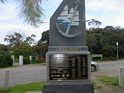 King decided to place a convict settlement at Port Phillip, mainly to stake a claim to southern Australia ahead of the French. In October 1803 a party led by Lt-Col David Collins
and consisting of about 400 people landed near the modern site of Sorrento
, where they established a settlement at Sullivan Bay which they called Hobart. Lack of fresh water and good timber, however, led this, the first attempt at European settlement in Victoria, to be abandoned in May 1804. Collins and party sailed to Tasmania
, where they established the modern Hobart
. Prior to abandonment one convict, William Buckley
, escaped from the settlement in a stolen canoe. Buckley later took up residence in a cave near Point Lonsdale on the western side of the bay's entrance, The Rip
.
Port Phillip was then left undisturbed until 1835, when settlers from Tasmania led by John Batman
and John Pascoe Fawkner
(who had been at the Sorrento settlement as a child) established Melbourne on the lower reaches of the Yarra. John Batman
encountered William Buckley
who then became an important participant in negotiations with the local indigenous tribesmen. In 1838 Geelong was founded, and became the main port serving the growing wool industry of the Western District. For a time Geelong rivalled Melbourne as the leading settlement on the bay, but the Gold Rush
which began in 1851 gave Melbourne a decisive edge as the largest town in Victoria.
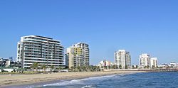 As Melbourne prospered, its wealthy classes discovered the recreational uses of Port Phillip. Bayside suburbs such as St Kilda
and Brighton
were established on the east shore of the bay. Later, resorts further south such as Sorrento
and Portsea
became popular. The more swampy western shores of the bay were not so favoured, and have been used mainly for non-residential purposes such as the Point Cook
Royal Australian Air Force
base and the Werribee Sewage Farm
. In recent decades the population along the western side of the bay has grown more rapidly.
In the 21st century, property along the Port Phillip coastline continues to be highly sought after. Port Phillip continues to be extensively used for recreational pursuits such as swimming, cycling, boating and fishing. The bay also features a number of historical walks and fauna reserves. The traditional land owners of the area have also been acknowledged at a number of sites.
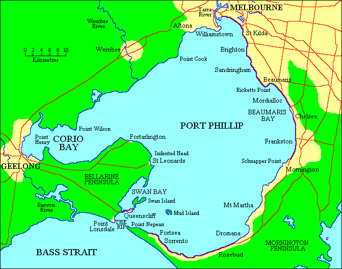 Port Phillip lies in southern Victoria, separated from Bass Strait
by the Bellarine Peninsula
to the southwest and Mornington Peninsula
to the southeast. It is the largest bay in Victoria and one of the largest inland bays in Australia. The narrow entrance to the bay, called the Rip
, between Point Lonsdale and Point Nepean
, features strong tidal streams made turbulent by the uneven contours of the seabed. The best time for small craft to enter the Rip is at slack water
. Large ships require expert local guidance to enter and exit, provided by the Port Phillip Sea Pilots. Work has commenced to deepen the channel
entrance, to allow newer, larger container ship
s to access Melbourne's docks.
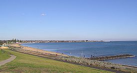
The eastern side of the bay is characterised by sandy beaches extending from St Kilda
, Sandringham
, Beaumaris
, Carrum
, and down the Mornington Peninsula
to Frankston
, Safety Beach
/Dromana
and Rye
to Portsea
. Longshore drift
carries sand
from south to north during winter and from north to south during summer. Cliff erosion
control has often resulted in sand starvation, necessitating offshore dredging to replenish the beach. On the western side of the bay there is a greater variety of beach types, seen at Queenscliff
, St Leonards
, Indented Head
, Portarlington
, and Eastern Beach.
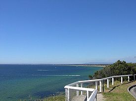
Numerous sandbanks and shoal
s occur in the southern section of the bay, and parts of the South Channel require occasional maintenance dredging. Swan Bay, adjacent to Queenscliff is an important feeding ground for waterbirds and migratory
wader
s. The Mud Islands
, off Sorrento
, are an important breeding habitat for White-faced Storm-Petrel
, Silver Gull
, Australian Pelican
and Pacific Gull
. Australian Gannet
s also breed on navigation beacon
s in this area, and it also hosts breeding colonies
of Australian Fur Seal. Salt marsh
es in the northwestern sections of the bay, such as that in the Werribee Sewage Farm
and the adjacent Spit Nature Conservation Reserve
, are within the Port Phillip Bay (Western Shoreline) and Bellarine Peninsula Ramsar Site
, listed as wetlands of international importance under the Ramsar Convention
, and the critically endangered Orange-bellied Parrot
is found at three wintering sites with saltmarsh habitat around Port Phillip and the Bellarine Peninsula
.
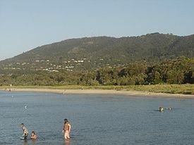
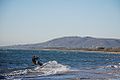
Port Phillip hosts many beaches, most of which are flat, shallow and long, with very small breaks making swimming quite safe. This attracts many tourists, mostly families, to the beaches of Port Phillip during the summer months and school holidays. Water sports such as body boarding and surfing
are difficult or impossible, except in extreme weather conditions. However, stand up paddle boarding (SUP), kite surfing and wind surfing are very popular. Most sandy beaches are located on the bay's northern, eastern and southern shorelines, while the western shorelines host a few sandy beaches, there mostly exists a greater variety of beaches, swampy wetlands and mangroves. The occasional pebble beach and rocky cliffs can also be found, mostly in the southern reaches.
s. Many sandy, muddy banks and shallows exist in its southern reaches, such as Mud Islands
, but most islands are located in the marshy shallows of Swan Bay. Some of the bay's major islands include:
and Sorrento
using two roll-on roll-off vessels. Ferries also run from St Kilda
to Williamstown, Victoria
across Hobsons Bay
. These ferries, like the many recreational cruises, mostly operate for tourists and run around the bay in various locations.
 The southern section of the Bay near the Heads is covered by extensive sand banks, known as the "Great Sand". A shipping channel was dredged in an east-west direction from the Heads to near Arthur's Seat late in the nineteenth century, and maintained ever since. Early shipping used piers at Sandridge (Port Melbourne), but later moved to various wharves along the Yarra River, which make up today's Port of Melbourne
. The Melbourne Harbor Trust and Geelong Harbor Trust were responsible for the piers and wharves in their respective cities - they are now the government owned Port of Melbourne Corporation
and the privately operated GeelongPort.
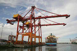
Today, the Port of Melbourne
has grown to become Australia's busiest commercial port, serving Australia's second largest city and handling an enormous amount of imports and exports into and out of the country. The Port of Geelong
also handles a large volume of dry bulk and oil, while nearby Port of Hastings
on Western Port
handles steel and oil products.
In 2004 the Victorian Government launched the Port Phillip Channel Deepening Project
to deepen the existing shipping channels and the lower Yarra to accommodate deeper draft vessels. The lower Yarra sediments were identified as likely to be contaminated with toxic chemicals and heavy metals, and were to be contained within a sealed berm clear of the shipping channels south of the Yarra entrance. The vessel chosen for the dredging is the Queen of the Netherlands
. 52 environmental groups, recreational fishing groups, and divers' groups formed the "Blue Wedges
" group to oppose the proposed channel deepening and dredging with organised protests carried out, culminating in the group taking action in the Federal Court in January 2008 against the Commonwealth to stop it signing off on the project. On 15 January 2008 it was announced that their appeal was dismissed, with dredging starting soon after. The government announced the completion of works in November 2009, ahead of schedule and $200 million under budget.
are a familiar sight in Port Phillip, and its waters are home to species such as Australian Fur Seals, Bottlenose dolphin
s, Common dolphin
s, and Humpback whale
s. The smooth toadfish
is one of the most common fishes in muddy areas. The bay has many endemic species including the bluedevil fish and fantastic sponge walls on the Lonsdale wall in the heads of the Bay.
A variety of seabird
s, such as Australasian Gannets, White-faced Storm-Petrel
s, Silver Gull
s, Pacific Gull
s, and Australian Pelican
s, breed on islands and feed on fish in the bay. Critically endangered
Orange-bellied Parrot
s winter on salt marsh
es around the coast.
, the Burrunan dolphin
(Tursiops australis). The other 50 or so of this rare species are to be found in the Gippsland Lakes
.
wrote two letters to a local schoolmaster at Dromana, Mr G.H. Rogers. His subject was his earliest recollections of an idyllic boyhood spent at Arthur's Seat Run, location of the historic McCrae Homestead
on the coast of the southern shores of the Bay, part of Mornington Peninsula
. In the letters he described in detail the natural history
of the area in the 1840s, and the species he particularly remembered 60 years later. In 1939, Charles Daley read an article before the Victorian Historical Society
based on these letters, which was published in their magazine in 1940 the year after a large bushfire in January, 1939, hastened the disappearance of much of the original surviving wildlife from the area.
The names of the species reflect the titles given to them by the original European settlers of the Bay.
The animals he observed as a young boy were "immense droves of kangaroos, brush kangaroos or wallaby, bandicoots, (two varieties) , great opossum, (two varieties) , ring tail, flying squirrel, flying mouse, dingoes or wild dogs in the gullies, that were caught in box traps with sliding doors, porcupine ant eater or echidna that were at the back of Arthur's Seat mountain, the great iguana, tree lizard- 5 feet, python, and the rock or sleeping lizard."
The trees were Coast Banksia, Honey suckle, and grass trees "with crowns for thatching". The gum of Xanthorrhoea australis
was used for carriage varnish.
In the waters of the bay he described "scallop shells which were used as an oil lamp with a bulrush wick, banks of cockles covered with birds, grey and white gulls, a 13-16 lb size schnapper ground off Mt Martha Point, mutton fish or venus ear- bait, coatfish, parrot fish, leather jackets, flathead, dog fish, sting rays, shark tailed rays, and pig fish (Castracion) "that he thought to be " very old."
On the beaches could be sighted " pelicans, penguins, Grey and grey white gull, called “bungan” by aborigines (the Bunurong
Mayone-bulluk clan), Small white and lavender gull, Pied oyster catchers, terns, cormorants, the little sandpiper, and musk ducks.
In the swamps (which have since been filled in) were "The Nankeen bird with one long white feather behind the ear, The rail, The bittern, The snipe and jack snipe, Several ducks- wood duck, black duck, Teal, Spoonbill, Black swan Geese, Cranes, Blue and white coots, Water hens, Kingfishers here and there and swamp or ground parrot with the barred tail feathers."
In the scrub by the waterholes were "honey eaters, warblers, red coat robins, emu wren with 2 long feathers in tail, Laughing jack ass- everywhere,
Butcher bird, also known as shrike or whistling jackass, Quail where coverage good in bottom of scrub, turkey at Boneo and the big swamp off the property."
On the flats were found spur wing plovers, minas, and leatherheads.
In timbers near the flats were "many varieties of parrots, Lorry, Rosella, Blue mountain or honeysuckle parrot, Sulphur –crested white cockatoo, Black cockatoo of two kinds", Grey cockatoo with scarlet crest and Corella or cockatoo parrot."
Among the cherry trees in the garden at the homestead were "bronzewing pigeon and satin birds, love birds and honeyeating parakeets."
Birds of prey were "eagle hawks, falcons, and owls, some white and of great size".
In 2008, the owner and master of Hong Kong-registered container vessel MV Sky Lucky were found liable for illegally disposing garbage into Port Phillip. convicted and fined $35,000.
s in the bay include;
ELISA Ramsden
's most popular tourist destinations. Many residents of Melbourne
holiday on the shorelines of the bay, particularly the eastern and southern shorelines, most annually, either camping in tents, caravan or villas in caravan parks, sharing rental houses or staying in holiday homes.
, windsurfing
, sailing
, boating
, scuba diving
, stand up paddle boarding (SUP) and other sports.
Port Phillip is home to 36 Yacht club
s. It also hosts the Melbourne to Hobart
and Melbourne to Launceston
Yacht Races. Port Phillip is also home to a number of marina
s, including large marinas at St Kilda, Geelong and Brighton. For the 1956 Summer Olympics
, it hosted the sailing
events.
Dozens of lifesaving clubs dot Port Phillip, especially on the east coast from Altona
to Frankston
. These clubs provide volunteer lifesaving services and conduct sporting carnivals.
Port Phillip is also known as a temperate water scuba diving
destination. The shore dives from beaches and piers around the Bay provide a wide variety of experiences on day and night dives. Boat diving in Port Phillip provides access to a remarkable variety of diving environments including wrecks, reefs, drift dives, scallop dives, seal dives and wall dives. Of particular interest are the five scuttled J-Class World War 1 submarines and the Ships' Graveyard off Torquay.
There are also a number of bike paths, including the Bayside Trail and the Hobsons Bay Coastal Trail
.

Port Phillip (also commonly referred to as Port Phillip Bay or (locally) just The Bay, is a large bay
Headlands and bays
Headlands and bays are two related features of the coastal environment.- Geology and geography :Headlands and bays are often found on the same coastline. A bay is surrounded by land on three sides, whereas a headland is surrounded by water on three sides. Headlands are characterized by high,...
in southern Victoria
Victoria (Australia)
Victoria is the second most populous state in Australia. Geographically the smallest mainland state, Victoria is bordered by New South Wales, South Australia, and Tasmania on Boundary Islet to the north, west and south respectively....
, Australia; it is the location of Melbourne. Geographically, the bay covers 1930 square kilometres (476,913 acre) and the shore stretches roughly 264 km (164 mi). Although it is extremely shallow for its size, most of the bay is navigable. The deepest portion is only 24 metres (78.7 ft), and half the region is shallower than 8 m (26.2 ft). The volume of the water in the bay is around 25 cubic kilometres (6 cu mi).
Prior to European settlement the area around Port Phillip was divided between the territories of the Wathaurong (to the west), Wurundjeri
Wurundjeri
The Wurundjeri are a people of the Indigenous Australian nation of the Woiwurrung language group, in the Kulin alliance, who occupy the Birrarung Valley, its tributaries and the present location of Melbourne, Australia...
(north) and Boonwurrung
Bunurong
The Bunurong are Indigenous Australians of the Kulin nation, who occupy South-Central Victoria, Australia. Prior to European settlement, they lived as all people of the Kulin nation lived, sustainably on the land, predominantly as hunters and gatherers, for tens of thousands of years...
(south and east) Nations. Its waters and coast are home to seal
Seal
Seal commonly refers to:* Pinniped, a diverse group of semi-aquatic marine mammals many of which are commonly called seals* Seal , a device which helps prevent leakage, contain pressure, or exclude contamination where two systems join...
s, whale
Whale
Whale is the common name for various marine mammals of the order Cetacea. The term whale sometimes refers to all cetaceans, but more often it excludes dolphins and porpoises, which belong to suborder Odontoceti . This suborder also includes the sperm whale, killer whale, pilot whale, and beluga...
s, dolphin
Dolphin
Dolphins are marine mammals that are closely related to whales and porpoises. There are almost forty species of dolphin in 17 genera. They vary in size from and , up to and . They are found worldwide, mostly in the shallower seas of the continental shelves, and are carnivores, mostly eating...
s, coral
Coral
Corals are marine animals in class Anthozoa of phylum Cnidaria typically living in compact colonies of many identical individual "polyps". The group includes the important reef builders that inhabit tropical oceans and secrete calcium carbonate to form a hard skeleton.A coral "head" is a colony of...
s and many kinds of seabird
Seabird
Seabirds are birds that have adapted to life within the marine environment. While seabirds vary greatly in lifestyle, behaviour and physiology, they often exhibit striking convergent evolution, as the same environmental problems and feeding niches have resulted in similar adaptations...
s and migratory
Bird migration
Bird migration is the regular seasonal journey undertaken by many species of birds. Bird movements include those made in response to changes in food availability, habitat or weather. Sometimes, journeys are not termed "true migration" because they are irregular or in only one direction...
wader
Wader
Waders, called shorebirds in North America , are members of the order Charadriiformes, excluding the more marine web-footed seabird groups. The latter are the skuas , gulls , terns , skimmers , and auks...
s.
The first Europeans to enter the bay were the crews of the Lady Nelson
Lady Nelson
The Royal Navy purchased Lady Nelson in 1799. She spent her career exploring the coast of Australia in the early years of the 19th century. She was the first known vessel to sail eastward through Bass Strait, the first to sail along the South coast of Victoria, as well as the first to enter Port...
, commanded by John Murray and, ten weeks later, the HMS Investigator commanded by Matthew Flinders
Matthew Flinders
Captain Matthew Flinders RN was one of the most successful navigators and cartographers of his age. In a career that spanned just over twenty years, he sailed with Captain William Bligh, circumnavigated Australia and encouraged the use of that name for the continent, which had previously been...
, in 1802. Subsequent expeditions into the bay took place in 1803 to establish the first settlement in Victoria, near Sorrento
Sorrento, Victoria
Sorrento is a township in Victoria, Australia, located on the shores of Port Phillip on the Mornington Peninsula, about one and a half hours south of Melbourne...
, but was abandoned in 1804. Thirty years later, settlers from Tasmania
Tasmania
Tasmania is an Australian island and state. It is south of the continent, separated by Bass Strait. The state includes the island of Tasmania—the 26th largest island in the world—and the surrounding islands. The state has a population of 507,626 , of whom almost half reside in the greater Hobart...
returned to establish Melbourne
Melbourne
Melbourne is the capital and most populous city in the state of Victoria, and the second most populous city in Australia. The Melbourne City Centre is the hub of the greater metropolitan area and the Census statistical division—of which "Melbourne" is the common name. As of June 2009, the greater...
, now the state
States and territories of Australia
The Commonwealth of Australia is a union of six states and various territories. The Australian mainland is made up of five states and three territories, with the sixth state of Tasmania being made up of islands. In addition there are six island territories, known as external territories, and a...
's capital city, at the mouth of the Yarra River
Yarra River
The Yarra River, originally Birrarung, is a river in east-central Victoria, Australia. The lower stretches of the river is where the city of Melbourne was established in 1835 and today Greater Melbourne dominates and influences the landscape of its lower reaches...
in 1835 and Geelong at Corio Bay
Corio Bay
Corio Bay is one of numerous bays in the southwest corner of Australia's Port Phillip, and is the bay on which abuts the City of Geelong. The nearby suburb of Corio takes its name from Corio Bay.-Name:...
in 1838. Today Port Phillip is the most densely populated catchment in Australia with an estimated 3 million people living around the bay; Melbourne's suburbs extend around much of the northern and eastern shorelines, and the city of Geelong sprawls around Corio Bay
Corio Bay
Corio Bay is one of numerous bays in the southwest corner of Australia's Port Phillip, and is the bay on which abuts the City of Geelong. The nearby suburb of Corio takes its name from Corio Bay.-Name:...
, in the bay's western arm.
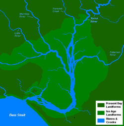
Formation and early history
Port Phillip was formed 7,000 to 10,000 years ago at the end of the last Ice AgeIce age
An ice age or, more precisely, glacial age, is a generic geological period of long-term reduction in the temperature of the Earth's surface and atmosphere, resulting in the presence or expansion of continental ice sheets, polar ice sheets and alpine glaciers...
, when the sea-level rose to drown what was then the lower reaches of the Yarra River
Yarra River
The Yarra River, originally Birrarung, is a river in east-central Victoria, Australia. The lower stretches of the river is where the city of Melbourne was established in 1835 and today Greater Melbourne dominates and influences the landscape of its lower reaches...
, vast river plains, wetlands and lakes. The Yarra and other tributaries flowed down what is now the middle of the bay, formed a lake in the southern reaches of the bay, dammed by The Heads
The Rip
"The Rip", also known as "The Heads", is a dangerous stretch of water in Victoria, Australia, connecting Port Phillip and Bass Strait. It is the only entrance for shipping into Port Phillip and hence into Melbourne. Because of large tidal flows through the relatively narrow channel from the bay to...
, subsequently pouring out into Bass Strait
Bass Strait
Bass Strait is a sea strait separating Tasmania from the south of the Australian mainland, specifically the state of Victoria.-Extent:The International Hydrographic Organization defines the limits of the Bass Strait as follows:...
.
The Aboriginal people were in occupation of the area long before the bay was formed, having arrived at least 20,000 years ago and possibly 40,000 years ago. Large piles of semi-fossilised sea-shells known as midden
Midden
A midden, is an old dump for domestic waste which may consist of animal bone, human excrement, botanical material, vermin, shells, sherds, lithics , and other artifacts and ecofacts associated with past human occupation...
s, can still be seen in places around the shoreline, marking the spots where Aboriginal people held feasts. They made a good living from the abundant sea-life, which included penguins and seals. In the cold season they wore possum-skin cloak
Possum-skin cloak
Possum-skin cloaks were a form of clothing worn by Aborigines in the south-east of Australia – present-day Victoria and New South Wales.The cloaks were made from numerous possum pelts sewn together with kangaroo sinew, and often decorated with significant incisions on the inside such as clan...
s and elaborate feathered head-dresses.
European exploration
In 1800, Lieutenant James GrantJames Grant (navigator)
James Grant was a British Royal Navy officer and navigator in the early nineteenth century. He made several voyages to Australia and Tasmania, and was the first to map parts of the south coast of Australia.-Early life:...
was the first known European to pass through Bass Strait from west to east, in the Lady Nelson. He was also the first to see, and crudely chart, the south coast from Cape Banks in South Australia to Wilson's Promontory in Victoria. Grant gave the name 'Governor King's Bay', to the body of water between Cape Otway and Wilson's Promontory, but did not venture in and discover Port Phillip.
The first Europeans to discover and enter Port Phillip, were the crew of the Lady Nelson
Lady Nelson
The Royal Navy purchased Lady Nelson in 1799. She spent her career exploring the coast of Australia in the early years of the 19th century. She was the first known vessel to sail eastward through Bass Strait, the first to sail along the South coast of Victoria, as well as the first to enter Port...
, commanded by John Murray, which entered the bay on 15 February 1802. Murray called the bay Port King after the Governor of New South Wales, Philip Gidley King
Philip Gidley King
Captain Philip Gidley King RN was a British naval officer and colonial administrator. He is best known as the official founder of the first European settlement on Norfolk Island and as the third Governor of New South Wales.-Early years and establishment of Norfolk Island settlement:King was born...
, but King later renamed it Port Phillip, in honour of his predecessor Arthur Phillip
Arthur Phillip
Admiral Arthur Phillip RN was a British admiral and colonial administrator. Phillip was appointed Governor of New South Wales, the first European colony on the Australian continent, and was the founder of the settlement which is now the city of Sydney.-Early life and naval career:Arthur Phillip...
.
About ten weeks after Murray, Matthew Flinders
Matthew Flinders
Captain Matthew Flinders RN was one of the most successful navigators and cartographers of his age. In a career that spanned just over twenty years, he sailed with Captain William Bligh, circumnavigated Australia and encouraged the use of that name for the continent, which had previously been...
in the Investigator also found and entered the port, unaware Murray had been there. The official history of Nicholas Baudin's explorations in Le Géographe
Baudin expedition of 1800 to 1802
The Baudin expedition of 1800 to 1803 was a French expedition to map the coast of Australia. Nicolas Baudin was selected as leader in October 1800...
claimed they too had sighted the entrance at that time (30 March 1802) but this is almost certainly a later embellishment or error, being absent from the ship's logs and Baudin's own accounts. As a result of Murray's and Flinders' reports, King sent Lieutenant Charles Robbins in the Cumberland
HMS Cumberland (1803)
HMS Cumberland was a 29 ton schooner built in Port Jackson, Australia, by Henry Moore in 1801. Under the command of Acting Lieutenant Charles Robbin, she was used for Charles Grimes survey of King Island and Port Phillip in early 1803. She was purchased in 1803 to convey Matthew Flinders to England...
to explore Port Phillip fully. One of his party, Charles Grimes
Charles Grimes
Charles Grimes was an English-born surveyor who did some valuable work in colonial Australia. He served as surveyor-general of New South Wales and discovered the Yarra River in what is now the state of Victoria. He is perhaps best known for being the surveyor who mapped the route of the Hobart...
, became the first European to walk right round the bay, and thus to discover the mouth of the Yarra, on 2 February 1803.
British settlement
David Collins (governor)
Colonel David Collins was the first Lieutenant Governor of the Colony of Van Diemens Land, founded in 1804, which in 1901 became the state of Tasmania in the Commonwealth of Australia.-Early life and military career:...
and consisting of about 400 people landed near the modern site of Sorrento
Sorrento, Victoria
Sorrento is a township in Victoria, Australia, located on the shores of Port Phillip on the Mornington Peninsula, about one and a half hours south of Melbourne...
, where they established a settlement at Sullivan Bay which they called Hobart. Lack of fresh water and good timber, however, led this, the first attempt at European settlement in Victoria, to be abandoned in May 1804. Collins and party sailed to Tasmania
Tasmania
Tasmania is an Australian island and state. It is south of the continent, separated by Bass Strait. The state includes the island of Tasmania—the 26th largest island in the world—and the surrounding islands. The state has a population of 507,626 , of whom almost half reside in the greater Hobart...
, where they established the modern Hobart
Hobart
Hobart is the state capital and most populous city of the Australian island state of Tasmania. Founded in 1804 as a penal colony,Hobart is Australia's second oldest capital city after Sydney. In 2009, the city had a greater area population of approximately 212,019. A resident of Hobart is known as...
. Prior to abandonment one convict, William Buckley
William Buckley
William, Will or Bill Buckley may refer to:* William F. Buckley, Jr. , American author and conservative commentator* William Frank Buckley, Sr. , lawyer in Tampico, Mexico...
, escaped from the settlement in a stolen canoe. Buckley later took up residence in a cave near Point Lonsdale on the western side of the bay's entrance, The Rip
The Rip
"The Rip", also known as "The Heads", is a dangerous stretch of water in Victoria, Australia, connecting Port Phillip and Bass Strait. It is the only entrance for shipping into Port Phillip and hence into Melbourne. Because of large tidal flows through the relatively narrow channel from the bay to...
.
Port Phillip was then left undisturbed until 1835, when settlers from Tasmania led by John Batman
John Batman
John Batman was an Australian grazier, businessman and explorer who is best known for his role in the founding of a settlement which became Melbourne and the colony of Victoria.-Life:...
and John Pascoe Fawkner
John Pascoe Fawkner
John Pascoe Fawkner was an early pioneer, businessman and politician of Melbourne, Victoria, Australia. In 1835 he financed a party of free settlers from Van Diemen's Land , to sail to the mainland in his ship, Enterprize...
(who had been at the Sorrento settlement as a child) established Melbourne on the lower reaches of the Yarra. John Batman
John Batman
John Batman was an Australian grazier, businessman and explorer who is best known for his role in the founding of a settlement which became Melbourne and the colony of Victoria.-Life:...
encountered William Buckley
William Buckley (convict)
William Buckley was an English convict who was transported to Australia, escaped, was given up for dead and lived in an Aboriginal community for many years....
who then became an important participant in negotiations with the local indigenous tribesmen. In 1838 Geelong was founded, and became the main port serving the growing wool industry of the Western District. For a time Geelong rivalled Melbourne as the leading settlement on the bay, but the Gold Rush
Gold rush
A gold rush is a period of feverish migration of workers to an area that has had a dramatic discovery of gold. Major gold rushes took place in the 19th century in Australia, Brazil, Canada, South Africa, and the United States, while smaller gold rushes took place elsewhere.In the 19th and early...
which began in 1851 gave Melbourne a decisive edge as the largest town in Victoria.
Modern use
St Kilda, Victoria
St Kilda is an inner city suburb of Melbourne, Victoria, Australia, 6 km south from Melbourne's central business district. Its Local Government Area is the City of Port Phillip...
and Brighton
Brighton, Victoria
Brighton is a suburb of Melbourne, Victoria, Australia, 11 km south-east from Melbourne's central business district. Its Local Government Area is the City of Bayside. At the 2006 Census, Brighton had a population of 20,651...
were established on the east shore of the bay. Later, resorts further south such as Sorrento
Sorrento, Victoria
Sorrento is a township in Victoria, Australia, located on the shores of Port Phillip on the Mornington Peninsula, about one and a half hours south of Melbourne...
and Portsea
Portsea, Victoria
Portsea is a resort town located across Port Phillip from Melbourne, Victoria, Australia. Its Local Government Area is the Shire of Mornington Peninsula....
became popular. The more swampy western shores of the bay were not so favoured, and have been used mainly for non-residential purposes such as the Point Cook
Point Cook, Victoria
Point Cook is a suburb in Melbourne, Victoria, Australia, 25 km south-west from Melbourne's central business district. Its Local Government Area is the City of Wyndham. At the 2006 Census, Point Cook had a population of 14,162, now it is estimated that the population of Point Cook is 32,167...
Royal Australian Air Force
Royal Australian Air Force
The Royal Australian Air Force is the air force branch of the Australian Defence Force. The RAAF was formed in March 1921. It continues the traditions of the Australian Flying Corps , which was formed on 22 October 1912. The RAAF has taken part in many of the 20th century's major conflicts...
base and the Werribee Sewage Farm
Werribee Sewage Farm
Werribee Sewage Farm or, more formally, the Western Treatment Plant of Melbourne Water, is an 110 km² sewage treatment farm adjacent to the town of Werribee, 30 km west of the city of Melbourne, Victoria, Australia, on the coast of Port Phillip Bay...
. In recent decades the population along the western side of the bay has grown more rapidly.
In the 21st century, property along the Port Phillip coastline continues to be highly sought after. Port Phillip continues to be extensively used for recreational pursuits such as swimming, cycling, boating and fishing. The bay also features a number of historical walks and fauna reserves. The traditional land owners of the area have also been acknowledged at a number of sites.
Geography
Bass Strait
Bass Strait is a sea strait separating Tasmania from the south of the Australian mainland, specifically the state of Victoria.-Extent:The International Hydrographic Organization defines the limits of the Bass Strait as follows:...
by the Bellarine Peninsula
Bellarine Peninsula
The Bellarine Peninsula is a peninsula located south-west of Melbourne in Victoria, Australia, surrounded by Port Phillip, Corio Bay and Bass Strait. The peninsula, together with the Mornington Peninsula separates Port Phillip from Bass Strait...
to the southwest and Mornington Peninsula
Mornington Peninsula
The Mornington Peninsula is a peninsula located south-east of Melbourne in Victoria, Australia. It is surrounded by Port Phillip to the west, Western Port to the east and Bass Strait to the south, and is connected to the mainland in the north. Geographically, the peninsula begins its protrusion...
to the southeast. It is the largest bay in Victoria and one of the largest inland bays in Australia. The narrow entrance to the bay, called the Rip
The Rip
"The Rip", also known as "The Heads", is a dangerous stretch of water in Victoria, Australia, connecting Port Phillip and Bass Strait. It is the only entrance for shipping into Port Phillip and hence into Melbourne. Because of large tidal flows through the relatively narrow channel from the bay to...
, between Point Lonsdale and Point Nepean
Point Nepean, Victoria
Point Nepean marks the southern point of The Rip and the most westerly point of the Mornington Peninsula, in Victoria, Australia. It was named after the British politician and colonial administrator, Sir Evan Nepean. It is within the suburb of Portsea...
, features strong tidal streams made turbulent by the uneven contours of the seabed. The best time for small craft to enter the Rip is at slack water
Slack water
Slack water, which used to be known as 'The stand of the tide', is a short period in a body of tidal water either side of high water or low water essentially when the water is completely unstressed, and therefore with no rise or fall of the tide and no movement either way in the tidal stream, and...
. Large ships require expert local guidance to enter and exit, provided by the Port Phillip Sea Pilots. Work has commenced to deepen the channel
Port Phillip Channel Deepening Project
The Port Phillip Channel Deepening Project began on 8 February 2008 to deepen the shipping channels leading to Melbourne, Australia, in Port Phillip to draught allow greater access for container ships. An estimated A$969 million, was to be spent on the works, with $150 million funded by taxpayers...
entrance, to allow newer, larger container ship
Container ship
Container ships are cargo ships that carry all of their load in truck-size intermodal containers, in a technique called containerization. They form a common means of commercial intermodal freight transport.-History:...
s to access Melbourne's docks.
The eastern side of the bay is characterised by sandy beaches extending from St Kilda
St Kilda, Victoria
St Kilda is an inner city suburb of Melbourne, Victoria, Australia, 6 km south from Melbourne's central business district. Its Local Government Area is the City of Port Phillip...
, Sandringham
Sandringham, Victoria
Sandringham is a suburb in Melbourne, Victoria, Australia, 16 km south-east from Melbourne's central business district. Its Local Government Area is the City of Bayside. At the 2006 Census, Sandringham had a population of 8693.-History:...
, Beaumaris
Beaumaris, Victoria
Beaumaris is a suburb in Melbourne, Victoria, Australia, 20 km south-east from Melbourne's central business district. Its Local Government Area is the City of Bayside. At the 2006 Census, Beaumaris had a population of 12,441....
, Carrum
Carrum, Victoria
Carrum is a suburb in Melbourne, Victoria, Australia, south-east from Melbourne's central business district. Its Local Government Area is the City of Kingston...
, and down the Mornington Peninsula
Mornington Peninsula
The Mornington Peninsula is a peninsula located south-east of Melbourne in Victoria, Australia. It is surrounded by Port Phillip to the west, Western Port to the east and Bass Strait to the south, and is connected to the mainland in the north. Geographically, the peninsula begins its protrusion...
to Frankston
Frankston, Victoria
Frankston is a suburb within the Greater Melbourne metropolitan area in Victoria, Australia. It is located 40 km southeast of the state capital Melbourne at the southernmost edge of Greater Melbourne, near the beginnings of the Mornington Peninsula...
, Safety Beach
Safety Beach, Victoria
Safety Beach is a suburb in Melbourne, Victoria, Australia. Its Local Government Area is the Shire of Mornington Peninsula.Safety Beach occupies slightly less than half the area of land between the foothills of Mount Martha and Arthurs Seat and borders Port Philip Bay to its west.There is a large...
/Dromana
Dromana, Victoria
Dromana is a suburb south of Melbourne, the capital city of Victoria, Australia, and is located on the Mornington Peninsula. Its Local Government Area is the Shire of Mornington Peninsula.-Geography:...
and Rye
Rye, Victoria
Rye is a seaside resort town, approximately 83 km south of Melbourne, Victoria, Australia, on the Mornington Peninsula, Victoria, Australia. Its bay beach is popular with swimmers, fishermen, yachtsmen and kitesurfers. Its ocean beach is also popular with surfers...
to Portsea
Portsea, Victoria
Portsea is a resort town located across Port Phillip from Melbourne, Victoria, Australia. Its Local Government Area is the Shire of Mornington Peninsula....
. Longshore drift
Longshore drift
Longshore drift consists of the transportation of sediments along a coast at an angle to the shoreline, which is dependent on prevailing wind direction, swash and backwash. This process occurs in the littoral zone, and in or within close proximity to the surf zone...
carries sand
Sand
Sand is a naturally occurring granular material composed of finely divided rock and mineral particles.The composition of sand is highly variable, depending on the local rock sources and conditions, but the most common constituent of sand in inland continental settings and non-tropical coastal...
from south to north during winter and from north to south during summer. Cliff erosion
Erosion
Erosion is when materials are removed from the surface and changed into something else. It only works by hydraulic actions and transport of solids in the natural environment, and leads to the deposition of these materials elsewhere...
control has often resulted in sand starvation, necessitating offshore dredging to replenish the beach. On the western side of the bay there is a greater variety of beach types, seen at Queenscliff
Queenscliff, Victoria
Queenscliff is a small town on the Bellarine Peninsula in southern Victoria, Australia, south of Swan Bay at the entrance to Port Phillip. It is the administrative centre for the Borough of Queenscliffe...
, St Leonards
St Leonards, Victoria
St Leonards is a coastal township near Geelong, Victoria, Australia, at the eastern end of the Bellarine Peninsula and the northern end of Swan Bay...
, Indented Head
Indented Head, Victoria
Indented Head is a small coastal township located on the Bellarine Peninsula, east of Geelong, in the Australian state of Victoria. The town lies on the coast of the Port Phillip bay between the towns of Portarlington and St Leonards.-History:...
, Portarlington
Portarlington, Victoria
Portarlington is a historic coastal township located on the Bellarine Peninsula, 27km from the city of Geelong, in the state of Victoria, Australia. The gently rising hills behind the town feature vineyards and olive groves, overlooking Port Phillip Bay. Portarlington is a popular family holiday...
, and Eastern Beach.
Numerous sandbanks and shoal
Shoal
Shoal, shoals or shoaling may mean:* Shoal, a sandbank or reef creating shallow water, especially where it forms a hazard to shipping* Shoal draught , of a boat with shallow draught which can pass over some shoals: see Draft...
s occur in the southern section of the bay, and parts of the South Channel require occasional maintenance dredging. Swan Bay, adjacent to Queenscliff is an important feeding ground for waterbirds and migratory
Bird migration
Bird migration is the regular seasonal journey undertaken by many species of birds. Bird movements include those made in response to changes in food availability, habitat or weather. Sometimes, journeys are not termed "true migration" because they are irregular or in only one direction...
wader
Wader
Waders, called shorebirds in North America , are members of the order Charadriiformes, excluding the more marine web-footed seabird groups. The latter are the skuas , gulls , terns , skimmers , and auks...
s. The Mud Islands
Mud Islands
The Mud Islands reserve is located within Port Phillip, about 90 km south-west of Melbourne, Australia, lying 10 km inside Port Phillip Heads, 7 km north of Portsea and 9 km east of Queenscliff. The land area of about 50 ha is made up of three low-lying islands surrounding a shallow tidal 35 ha...
, off Sorrento
Sorrento, Victoria
Sorrento is a township in Victoria, Australia, located on the shores of Port Phillip on the Mornington Peninsula, about one and a half hours south of Melbourne...
, are an important breeding habitat for White-faced Storm-Petrel
White-faced Storm-petrel
The White-faced Storm Petrel , also known as White-faced Petrel is a small seabird of the storm-petrel family. It is the only member of the monotypic genus Pelagodroma....
, Silver Gull
Silver Gull
The Silver Gull also known simply as "seagull" in Australia, is the most common gull seen in Australia. It has been found throughout the continent, but particularly coastal areas. The South African Hartlaub's Gull and the New Zealand Red-billed Gull The Silver Gull (Chroicocephalus...
, Australian Pelican
Australian Pelican
The Australian Pelican is a large water bird, widespread on the inland and coastal waters of Australia and New Guinea, also in Fiji, parts of Indonesia and as a vagrant to New Zealand.-Taxonomy:...
and Pacific Gull
Pacific Gull
The Pacific Gull is a very large gull, native to the coasts of Australia. It is moderately common between Carnarvon in the west, and Sydney in the east, although it has become scarce in some parts of the south-east, as a result of competition from the Kelp Gull, which has "self-introduced" since...
. Australian Gannet
Australian Gannet
The Australasian Gannet is a large seabird of the gannet family Sulidae....
s also breed on navigation beacon
Beacon
A beacon is an intentionally conspicuous device designed to attract attention to a specific location.Beacons can also be combined with semaphoric or other indicators to provide important information, such as the status of an airport, by the colour and rotational pattern of its airport beacon, or of...
s in this area, and it also hosts breeding colonies
Rookery
A rookery is a colony of breeding animals, generally birds. A rook is a Northern European and Central Asian member of the crow family, which nest in prominent colonies at the tops of trees. The term is applied to the nesting place of birds, such as crows and rooks, the source of the term...
of Australian Fur Seal. Salt marsh
Salt marsh
A salt marsh is an environment in the upper coastal intertidal zone between land and salt water or brackish water, it is dominated by dense stands of halophytic plants such as herbs, grasses, or low shrubs. These plants are terrestrial in origin and are essential to the stability of the salt marsh...
es in the northwestern sections of the bay, such as that in the Werribee Sewage Farm
Werribee Sewage Farm
Werribee Sewage Farm or, more formally, the Western Treatment Plant of Melbourne Water, is an 110 km² sewage treatment farm adjacent to the town of Werribee, 30 km west of the city of Melbourne, Victoria, Australia, on the coast of Port Phillip Bay...
and the adjacent Spit Nature Conservation Reserve
Spit Nature Conservation Reserve
The Spit Nature Conservation Reserve is a 300 ha nature reserve on the north-western shore of Port Phillip, a large bay in Victoria, Australia. It consists of public land set aside to conserve and protect species, communities and habitats of indigenous plants and animals...
, are within the Port Phillip Bay (Western Shoreline) and Bellarine Peninsula Ramsar Site
Port Phillip Bay (Western Shoreline) and Bellarine Peninsula Ramsar Site
The Port Phillip Bay and Bellarine Peninsula Ramsar Site is one of the Australian sites listed under the Ramsar Convention as a wetland of international importance. It was designated on 15 December 1982, and is listed as Ramsar Site No.266...
, listed as wetlands of international importance under the Ramsar Convention
Ramsar Convention
The Ramsar Convention is an international treaty for the conservation and sustainable utilization of wetlands, i.e., to stem the progressive encroachment on and loss of wetlands now and in the future, recognizing the fundamental ecological functions of wetlands and their economic, cultural,...
, and the critically endangered Orange-bellied Parrot
Orange-bellied Parrot
The Orange-bellied Parrot is a small broad-tailed parrot endemic to southern Australia, and one of only two species of parrot which migrate. The adult male is distinguished by its bright grass-green upperparts, yellow underparts and orange belly patch. The adult female and juvenile are duller...
is found at three wintering sites with saltmarsh habitat around Port Phillip and the Bellarine Peninsula
Bellarine Peninsula
The Bellarine Peninsula is a peninsula located south-west of Melbourne in Victoria, Australia, surrounded by Port Phillip, Corio Bay and Bass Strait. The peninsula, together with the Mornington Peninsula separates Port Phillip from Bass Strait...
.
Beaches
Port Phillip hosts many beaches, most of which are flat, shallow and long, with very small breaks making swimming quite safe. This attracts many tourists, mostly families, to the beaches of Port Phillip during the summer months and school holidays. Water sports such as body boarding and surfing
Surfing
Surfing' is a surface water sport in which the surfer rides a surfboard on the crest and face of a wave which is carrying the surfer towards the shore...
are difficult or impossible, except in extreme weather conditions. However, stand up paddle boarding (SUP), kite surfing and wind surfing are very popular. Most sandy beaches are located on the bay's northern, eastern and southern shorelines, while the western shorelines host a few sandy beaches, there mostly exists a greater variety of beaches, swampy wetlands and mangroves. The occasional pebble beach and rocky cliffs can also be found, mostly in the southern reaches.
- Major beaches include: St. KildaSt Kilda, VictoriaSt Kilda is an inner city suburb of Melbourne, Victoria, Australia, 6 km south from Melbourne's central business district. Its Local Government Area is the City of Port Phillip...
Beach, BrightonBrighton, VictoriaBrighton is a suburb of Melbourne, Victoria, Australia, 11 km south-east from Melbourne's central business district. Its Local Government Area is the City of Bayside. At the 2006 Census, Brighton had a population of 20,651...
Beach, SandringhamSandringham, VictoriaSandringham is a suburb in Melbourne, Victoria, Australia, 16 km south-east from Melbourne's central business district. Its Local Government Area is the City of Bayside. At the 2006 Census, Sandringham had a population of 8693.-History:...
Beach, Dromana Beach
Rivers and creeks
- Rivers: Yarra RiverYarra RiverThe Yarra River, originally Birrarung, is a river in east-central Victoria, Australia. The lower stretches of the river is where the city of Melbourne was established in 1835 and today Greater Melbourne dominates and influences the landscape of its lower reaches...
, Maribyrnong RiverMaribyrnong riverThe Maribyrnong River rises about 50 km north of Melbourne, Victoria , near Mount Macedon. It flows generally southward and combines with the Yarra River to flow into Port Phillip....
, Patterson RiverPatterson RiverThe Patterson River is a partly man-made waterway located approximately 35km south-east of Melbourne, Australia in Patterson Lakes, Carrum and Bonbeach....
, Little RiverLittle River, VictoriaLittle River is a town in Victoria, Australia, 51 km south-west from Melbourne's central business district. Its Local Government Area are the Cities of Wyndham and Greater Geelong. At the 2006 Census, Little River had a population of 375.-History:...
, Werribee RiverWerribee RiverThe Werribee River is located on the plain west of Melbourne, Victoria, Australia. The headwaters of a tributary, the Lerderderg River, are north of Ballan near Daylesford and it flows across the basalt plain, through the suburb of Werribee to enter Port Phillip. A linear park follows the Werribee...
. - Creeks: Kananook Creek, Sweetwater CreekSweetwater CreekSweetwater Creek may refer to:* Sweetwater Creek , a novel by Anne Rivers Siddons* Sweetwater Creek, Florida, an unincorporated community in Hillsborough County, Florida* Sweetwater Creek , Georgia...
, Cowies CreekCowies CreekCowies Creek is a creek in the northern suburbs of Geelong, Victoria, Australia. It flows from wetlands in Moorabool to Corio Quay, Corio Bay in Port Phillip. The mouth of Cowies Creek was excavated to become Corio Quay from 1909, with the creation of Lascelles Wharf to the north in later years....
, Kororoit CreekKororoit CreekKororoit Creek is a major waterway of over 80 km in length in the north-west and western parts of Melbourne. Its headwaters are north of Sunbury at 400m above sea level in ordovician geology...
, Chinamans Creek.
Islands
Due to its shallow depth, numerous artificial islands and forts have been built, however, despite the depth, it only hosts a few true islandIsland
An island or isle is any piece of sub-continental land that is surrounded by water. Very small islands such as emergent land features on atolls can be called islets, cays or keys. An island in a river or lake may be called an eyot , or holm...
s. Many sandy, muddy banks and shallows exist in its southern reaches, such as Mud Islands
Mud Islands
The Mud Islands reserve is located within Port Phillip, about 90 km south-west of Melbourne, Australia, lying 10 km inside Port Phillip Heads, 7 km north of Portsea and 9 km east of Queenscliff. The land area of about 50 ha is made up of three low-lying islands surrounding a shallow tidal 35 ha...
, but most islands are located in the marshy shallows of Swan Bay. Some of the bay's major islands include:
- Swan Island
- Mud IslandsMud IslandsThe Mud Islands reserve is located within Port Phillip, about 90 km south-west of Melbourne, Australia, lying 10 km inside Port Phillip Heads, 7 km north of Portsea and 9 km east of Queenscliff. The land area of about 50 ha is made up of three low-lying islands surrounding a shallow tidal 35 ha...
- Duck IslandDuck Island (Victoria)Duck Island, a small barrier island, lies 1.5 km north of Swan Island and south of Edwards Point in the main entrance to Swan Bay from Port Phillip in southern Victoria, Australia. It is part of the Port Phillip Heads Marine National Park and the plants and animals on and around the island are...
- South Channel FortSouth Channel FortSouth Channel Fort is a 0.7 ha artificial island in southern Port Phillip, Victoria, Australia, 6 km north-east of the town of Sorrento. It was part of a network of fortifications protecting the narrow entrance to Port Phillip....
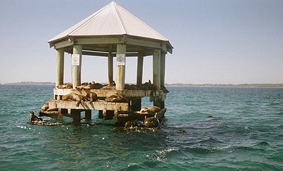
(artificial) - Pope's EyePope's EyePope's Eye is the uncompleted foundation for an island fort intended to defend the entrance to Port Phillip in the state of Victoria, Australia. It is less than a kilometre south-west of the former Chinaman's Hat....
(artificial)
Surrounding mountains and hills
- Arthurs SeatArthurs Seat, VictoriaArthurs Seat is a hill and locality on the Mornington Peninsula, within the Shire of Mornington Peninsula, about 75 km south east of Melbourne, Australia....
314m - Mount MarthaMount Martha, VictoriaMount Martha is a suburb in Melbourne, Victoria, Australia, located 60 km south-east of Melbourne's central business district. Its Local Government Area is the Shire of Mornington Peninsula. It is located on the south-eastern shores of Port Phillip and offers a bathing beach...
160m - Mount ElizaMount Eliza, VictoriaMount Eliza is an outer suburb south-east of Melbourne, Victoria, Australia. It is in the Local Government Area of the Shire of Mornington Peninsula...
- Olivers Hill
Surrounding lakes
- Albert Park Lake
- Lake Carramar, Lake Illawong and Lake Legana of Patterson LakesPatterson Lakes, VictoriaPatterson Lakes is a suburb in outer south-east Melbourne, Victoria, Australia, and is located 32 km south-east of Melbourne's central business district. Its Local Government Area is the City of Kingston. In the 2006 Census Patterson Lakes had a population of 7,235 people.Patterson Lakes consists...
- Lake VictoriaLake Victoria (Victoria).Lake Victoria is a 1.39 km² shallow saline lake on the Bellarine Peninsula, Victoria, Australia, close to the township of Point Lonsdale and part of the Lonsdale Lakes Nature Reserve administered by Parks Victoria. It is separated from Bass Strait by a narrow strip of coastal dunes...
- Salt LagoonSt Leonards Salt LagoonSt Leonards Salt Lagoon is a former marine embayment, isolated by coastal deposition from Port Phillip Bay, at St Leonards, Victoria, Australia. It now forms a shallow and hypersaline lake, of about 50 ha, which is often dry. It is a State Nature Reserve....
- Lake ConnewarreLake ConnewarreLake Connewarre is a shallow estuarine lake located on the Barwon River, on the Bellarine Peninsula near Geelong, Victoria. It is adjacent to, and downstream from, the freshwater Reedy Lake...
- Lake BorrieLake Borrie WetlandsLake Borrie Wetlands is located in Victoria, Australia within the Western Treatment Plant at Werribee. This plant is administered by Melbourne Water. It forms part of the Port Phillip Bay and Bellarine Peninsula Ramsar Site as a wetland of international importance...
- RAAF LakeRAAF WilliamsRAAF Williams comprises the two bases of Point Cook and Laverton. Both establishments previously existed as separate RAAF Bases until 1999 when they were amalgamated to form RAAF Williams...
- Sanctuary LakesSanctuary Lakes, VictoriaSanctuary Lakes is a golfing estate in Point Cook, Victoria, Australia including an 18-hole Greg Norman designed golf course and 168 acres of lake.-Scorecard:-External links:*...
(artificial) - Cherry LakeCherry Lake (Victoria)Cherry Lake is part of historical coastal wetlands in Altona, a suburb of Melbourne, Australia. The wetlands were converted to a lake with construction of retaining walls, levees, and flow channels...
Ferries
Peninsula Searoad Transport operates a vehicular ferry service across the mouth of the bay between QueenscliffQueenscliff, Victoria
Queenscliff is a small town on the Bellarine Peninsula in southern Victoria, Australia, south of Swan Bay at the entrance to Port Phillip. It is the administrative centre for the Borough of Queenscliffe...
and Sorrento
Sorrento, Victoria
Sorrento is a township in Victoria, Australia, located on the shores of Port Phillip on the Mornington Peninsula, about one and a half hours south of Melbourne...
using two roll-on roll-off vessels. Ferries also run from St Kilda
St Kilda, Victoria
St Kilda is an inner city suburb of Melbourne, Victoria, Australia, 6 km south from Melbourne's central business district. Its Local Government Area is the City of Port Phillip...
to Williamstown, Victoria
Williamstown, Victoria
Williamstown is a suburb in Melbourne, Victoria, Australia, 8 km south-west from Melbourne's central business district. Its Local Government Area is the City of Hobsons Bay. At the 2006 Census, Williamstown had a population of 12,733....
across Hobsons Bay
Hobsons Bay
Hobsons Bay is a bay in Port Phillip, Victoria, Australia....
. These ferries, like the many recreational cruises, mostly operate for tourists and run around the bay in various locations.
- Spirit of TasmaniaSpirit of TasmaniaSpirit of Tasmania may refer to:* The trading name of TT-Line Pty. Ltd.* One of the following ferries that sailed under the name of Spirit of Tasmania during its careers:** ** ** **...
Ferry (passenger and vehicles)
- Between: Station Pier, Port Melbourne
- And: DevonportDevonport, Tasmania-Sport:The Devonport Football Club is an Australian Rules team competing in the Tasmanian Statewide League. The Devonport Rugby Club is a Rugby Union team competing in the Tasmanian Rugby Union Statewide League...
, TasmaniaTasmaniaTasmania is an Australian island and state. It is south of the continent, separated by Bass Strait. The state includes the island of Tasmania—the 26th largest island in the world—and the surrounding islands. The state has a population of 507,626 , of whom almost half reside in the greater Hobart...
- Searoad Ferries (passenger and vehicles)
- Between: Sorrento Pier, SorrentoSorrento, VictoriaSorrento is a township in Victoria, Australia, located on the shores of Port Phillip on the Mornington Peninsula, about one and a half hours south of Melbourne...
- And: The Cut Pier, QueenscliffQueenscliff, VictoriaQueenscliff is a small town on the Bellarine Peninsula in southern Victoria, Australia, south of Swan Bay at the entrance to Port Phillip. It is the administrative centre for the Borough of Queenscliffe...
History
Port of Melbourne
The Port of Melbourne is Australia's busiest port for containerised and general cargo. It is located in Melbourne, Victoria and covers an area at the mouth of the Yarra River, downstream of Bolte Bridge, which is at the head of Port Phillip, as well as several piers on the bay itself...
. The Melbourne Harbor Trust and Geelong Harbor Trust were responsible for the piers and wharves in their respective cities - they are now the government owned Port of Melbourne Corporation
Port of Melbourne Corporation
The Port of Melbourne Corporation is a statutory body established by the Victorian Government. The Corporation commenced operations on 1 July 2003, when it took over the management of the Port of Melbourne from Melbourne Port Corporation...
and the privately operated GeelongPort.
Today, the Port of Melbourne
Port of Melbourne
The Port of Melbourne is Australia's busiest port for containerised and general cargo. It is located in Melbourne, Victoria and covers an area at the mouth of the Yarra River, downstream of Bolte Bridge, which is at the head of Port Phillip, as well as several piers on the bay itself...
has grown to become Australia's busiest commercial port, serving Australia's second largest city and handling an enormous amount of imports and exports into and out of the country. The Port of Geelong
Port of Geelong
The Port of Geelong is located on the shores of Corio Bay in Geelong, Victoria, Australia. The port is the sixth-largest in Australia by tonnage....
also handles a large volume of dry bulk and oil, while nearby Port of Hastings
Hastings, Victoria
Hastings is a suburb on the Mornington Peninsula, Victoria, Australia, as a part of the urban enclave on Westernport comprising Hastings, Bittern, Crib Point, Tyabb, and Somerville. Its Local Government Area is the Shire of Mornington Peninsula...
on Western Port
Western Port
Western Port, is sometimes called "Western Port Bay", is a large tidal bay in southern Victoria, Australia opening into Bass Strait. It is the second largest bay in Victoria. Geographically, it is dominated by the two large islands; French Island and Phillip Island. Contrary to its name, it lies to...
handles steel and oil products.
In 2004 the Victorian Government launched the Port Phillip Channel Deepening Project
Port Phillip Channel Deepening Project
The Port Phillip Channel Deepening Project began on 8 February 2008 to deepen the shipping channels leading to Melbourne, Australia, in Port Phillip to draught allow greater access for container ships. An estimated A$969 million, was to be spent on the works, with $150 million funded by taxpayers...
to deepen the existing shipping channels and the lower Yarra to accommodate deeper draft vessels. The lower Yarra sediments were identified as likely to be contaminated with toxic chemicals and heavy metals, and were to be contained within a sealed berm clear of the shipping channels south of the Yarra entrance. The vessel chosen for the dredging is the Queen of the Netherlands
Queen of the Netherlands (ship)
The Queen of the Netherlands is a Dutch trailing suction hopper dredging ship constructed in 1998. The vessel has been used in high-profile salvage and dredging operations including the investigation into the Swissair Flight 111 crash and in the Port Phillip Channel Deepening Project...
. 52 environmental groups, recreational fishing groups, and divers' groups formed the "Blue Wedges
Blue Wedges
Blue Wedges is a conservation organisation in conflict with Australia's Victorian government policy to deepen shipping channels in Port Phillip and the large scale development of Ramsar listed Westernport...
" group to oppose the proposed channel deepening and dredging with organised protests carried out, culminating in the group taking action in the Federal Court in January 2008 against the Commonwealth to stop it signing off on the project. On 15 January 2008 it was announced that their appeal was dismissed, with dredging starting soon after. The government announced the completion of works in November 2009, ahead of schedule and $200 million under budget.
Shipping channels
- South Channel - Extends from the area of the rip in an easterly direction where it terminates off the coast of Arthurs Seat. Vessels with a draught of 11.6m can be navigated through the channel at all tides. This is the main commercial shipping channel in the south of the bay allowing large ships access between the entrance of the bay and its middle regions.
- West Channel - Extends from the area of the rip, heads towards the north-west and ends off the coast of St LeonardsSt Leonards, VictoriaSt Leonards is a coastal township near Geelong, Victoria, Australia, at the eastern end of the Bellarine Peninsula and the northern end of Swan Bay...
. The depth varies, in May 1998 there was a minimum of 4.1 metres. Non-commercial vessels are still navigated through the channel, however it is no longer used for commercial shipping.
- The RipThe Rip"The Rip", also known as "The Heads", is a dangerous stretch of water in Victoria, Australia, connecting Port Phillip and Bass Strait. It is the only entrance for shipping into Port Phillip and hence into Melbourne. Because of large tidal flows through the relatively narrow channel from the bay to...
- Also referred to as "the heads" for shipping purposes, vessels with a draught of 11.6m can be navigated through the Heads during any tide.
- Melbourne Channels - Extends northwards through Hobsons Bay towards Station Pier and the entrance to the Yarra River. It is dredged to a depth of 13.1 metres and is the main shipping channel through the north of the bay into Melbourne's ports and docks. The channels include:
- Melbourne Channel
- Williamstown Channel
- Port Melbourne Channel
- Geelong Channels - Begins off the coast of Point Richards and runs in a westerly direction through Outer Harbour and into Corio Bay where it splits in two heading north towards the modern Port of GeelongPort of GeelongThe Port of Geelong is located on the shores of Corio Bay in Geelong, Victoria, Australia. The port is the sixth-largest in Australia by tonnage....
and south towards Cunningham Pier. The City Channel while once used for wool exports is no longer used for commercial shipping. The channels include:
- Point Richards Shipping Channel
- Wilson Spit Shipping Channel
- Hopetoun Shipping Channel
- City Channel
- Corio Channel
Shipping and cargo docks
- Station PierStation PierStation Pier is an historic pier on Port Phillip, in Port Melbourne, Victoria, Australia. Opened in 1854, the pier is Melbourne's primary passenger terminal, servicing interstate ferries and cruise ships, and is listed on the Victorian Heritage Register....
- Princess Pier
- Webb Dock
- Gellibrand Pier
- Point Wilson Pier
- Refinery Pier
- Lascelles Wharf
- Corio Quay
- Bulk Grain Pier
- Cunningham Pier
- Point Henry Pier
Ecology
JellyfishJellyfish
Jellyfish are free-swimming members of the phylum Cnidaria. Medusa is another word for jellyfish, and refers to any free-swimming jellyfish stages in the phylum Cnidaria...
are a familiar sight in Port Phillip, and its waters are home to species such as Australian Fur Seals, Bottlenose dolphin
Bottlenose Dolphin
Bottlenose dolphins, the genus Tursiops, are the most common and well-known members of the family Delphinidae, the family of oceanic dolphins. Recent molecular studies show the genus contains two species, the common bottlenose dolphin and the Indo-Pacific bottlenose dolphin , instead of one...
s, Common dolphin
Common dolphin
The common dolphin is the name given to two species of dolphin making up the genus Delphinus.Prior to the mid-1990s, most taxonomists only recognised one species in this genus, the common dolphin Delphinus delphis...
s, and Humpback whale
Humpback Whale
The humpback whale is a species of baleen whale. One of the larger rorqual species, adults range in length from and weigh approximately . The humpback has a distinctive body shape, with unusually long pectoral fins and a knobbly head. It is an acrobatic animal, often breaching and slapping the...
s. The smooth toadfish
Smooth toadfish
The smooth toadfish or smooth toado is a species of fish in the Tetraodontidae family of order Tetraodontiformes, found along Australia's eastern and southeast coast, from northern Queensland to South Australia and Tasmania...
is one of the most common fishes in muddy areas. The bay has many endemic species including the bluedevil fish and fantastic sponge walls on the Lonsdale wall in the heads of the Bay.
A variety of seabird
Seabird
Seabirds are birds that have adapted to life within the marine environment. While seabirds vary greatly in lifestyle, behaviour and physiology, they often exhibit striking convergent evolution, as the same environmental problems and feeding niches have resulted in similar adaptations...
s, such as Australasian Gannets, White-faced Storm-Petrel
White-faced Storm-petrel
The White-faced Storm Petrel , also known as White-faced Petrel is a small seabird of the storm-petrel family. It is the only member of the monotypic genus Pelagodroma....
s, Silver Gull
Silver Gull
The Silver Gull also known simply as "seagull" in Australia, is the most common gull seen in Australia. It has been found throughout the continent, but particularly coastal areas. The South African Hartlaub's Gull and the New Zealand Red-billed Gull The Silver Gull (Chroicocephalus...
s, Pacific Gull
Pacific Gull
The Pacific Gull is a very large gull, native to the coasts of Australia. It is moderately common between Carnarvon in the west, and Sydney in the east, although it has become scarce in some parts of the south-east, as a result of competition from the Kelp Gull, which has "self-introduced" since...
s, and Australian Pelican
Australian Pelican
The Australian Pelican is a large water bird, widespread on the inland and coastal waters of Australia and New Guinea, also in Fiji, parts of Indonesia and as a vagrant to New Zealand.-Taxonomy:...
s, breed on islands and feed on fish in the bay. Critically endangered
Critically endangered
Version 2010.3 of the IUCN Red List of Threatened Species identified 3744 Critically Endangered species, subspecies and varieties, stocks and subpopulations.Critically Endangered by kingdom:*1993 Animalia*2 Fungi*1745 Plantae*4 Protista-References:...
Orange-bellied Parrot
Orange-bellied Parrot
The Orange-bellied Parrot is a small broad-tailed parrot endemic to southern Australia, and one of only two species of parrot which migrate. The adult male is distinguished by its bright grass-green upperparts, yellow underparts and orange belly patch. The adult female and juvenile are duller...
s winter on salt marsh
Salt marsh
A salt marsh is an environment in the upper coastal intertidal zone between land and salt water or brackish water, it is dominated by dense stands of halophytic plants such as herbs, grasses, or low shrubs. These plants are terrestrial in origin and are essential to the stability of the salt marsh...
es around the coast.
Burrunan dolphins
The Bay is home to about 100 of the recently described species of Bottlenose dolphinBottlenose Dolphin
Bottlenose dolphins, the genus Tursiops, are the most common and well-known members of the family Delphinidae, the family of oceanic dolphins. Recent molecular studies show the genus contains two species, the common bottlenose dolphin and the Indo-Pacific bottlenose dolphin , instead of one...
, the Burrunan dolphin
Burrunan dolphin
The Burrunan dolphin is a recently-described species of bottlenose dolphin found in parts of Victoria, Australia. By size, the Burrunan dolphin is between the other two species of bottlenose dolphin and only around 150 individuals have been found in two locations.-Taxonomy:The species was formally...
(Tursiops australis). The other 50 or so of this rare species are to be found in the Gippsland Lakes
Gippsland Lakes
The Gippsland Lakes are a network of lakes, marshes and lagoons in east Gippsland, Victoria, Australia covering an area of about 600 km2. The largest of the lakes are Lake Wellington , Lake King and Lake Victoria. They are fed by the Avon, Thomson, Latrobe, Mitchell, Nicholson and Tambo...
.
Original flora and fauna
In 1906, George Gordon McCraeGeorge Gordon McCrae
-Early life:McCrae was born in Leith, Scotland; his father was Andrew Murison McCrae, a writer; his mother was Georgiana McCrae, a painter. George attended a preparatory school in London, and later received lessons from his mother...
wrote two letters to a local schoolmaster at Dromana, Mr G.H. Rogers. His subject was his earliest recollections of an idyllic boyhood spent at Arthur's Seat Run, location of the historic McCrae Homestead
McCrae Homestead
McCrae Homestead is an historic property located in McCrae, Victoria, Australia. It was built at the foot of Arthurs Seat, a small mountain, near the shores of Port Phillip in 1844 by Andrew McCrae, a lawyer, and his wife Georgiana Huntly McCrae...
on the coast of the southern shores of the Bay, part of Mornington Peninsula
Mornington Peninsula
The Mornington Peninsula is a peninsula located south-east of Melbourne in Victoria, Australia. It is surrounded by Port Phillip to the west, Western Port to the east and Bass Strait to the south, and is connected to the mainland in the north. Geographically, the peninsula begins its protrusion...
. In the letters he described in detail the natural history
Natural history
Natural history is the scientific research of plants or animals, leaning more towards observational rather than experimental methods of study, and encompasses more research published in magazines than in academic journals. Grouped among the natural sciences, natural history is the systematic study...
of the area in the 1840s, and the species he particularly remembered 60 years later. In 1939, Charles Daley read an article before the Victorian Historical Society
Royal Historical Society of Victoria
The Royal Historical Society of Victoria is a community organisation promoting the history of the state of Victoria, Australia. It functions to promote and research the history of that state after settlement, and as an umbrella organisation for more than 300 affiliated societies.It is operated by...
based on these letters, which was published in their magazine in 1940 the year after a large bushfire in January, 1939, hastened the disappearance of much of the original surviving wildlife from the area.
The names of the species reflect the titles given to them by the original European settlers of the Bay.
The animals he observed as a young boy were "immense droves of kangaroos, brush kangaroos or wallaby, bandicoots, (two varieties) , great opossum, (two varieties) , ring tail, flying squirrel, flying mouse, dingoes or wild dogs in the gullies, that were caught in box traps with sliding doors, porcupine ant eater or echidna that were at the back of Arthur's Seat mountain, the great iguana, tree lizard- 5 feet, python, and the rock or sleeping lizard."
The trees were Coast Banksia, Honey suckle, and grass trees "with crowns for thatching". The gum of Xanthorrhoea australis
Xanthorrhoea australis
Xanthorrhoea australis, the Grass-tree or Black Boy is a unique Australian plant. It is the most commonly seen species of the genus Xanthorrhoea . Its fire-blackened trunk can grow up to several metres tall and is often branched...
was used for carriage varnish.
In the waters of the bay he described "scallop shells which were used as an oil lamp with a bulrush wick, banks of cockles covered with birds, grey and white gulls, a 13-16 lb size schnapper ground off Mt Martha Point, mutton fish or venus ear- bait, coatfish, parrot fish, leather jackets, flathead, dog fish, sting rays, shark tailed rays, and pig fish (Castracion) "that he thought to be " very old."
On the beaches could be sighted " pelicans, penguins, Grey and grey white gull, called “bungan” by aborigines (the Bunurong
Bunurong
The Bunurong are Indigenous Australians of the Kulin nation, who occupy South-Central Victoria, Australia. Prior to European settlement, they lived as all people of the Kulin nation lived, sustainably on the land, predominantly as hunters and gatherers, for tens of thousands of years...
Mayone-bulluk clan), Small white and lavender gull, Pied oyster catchers, terns, cormorants, the little sandpiper, and musk ducks.
In the swamps (which have since been filled in) were "The Nankeen bird with one long white feather behind the ear, The rail, The bittern, The snipe and jack snipe, Several ducks- wood duck, black duck, Teal, Spoonbill, Black swan Geese, Cranes, Blue and white coots, Water hens, Kingfishers here and there and swamp or ground parrot with the barred tail feathers."
In the scrub by the waterholes were "honey eaters, warblers, red coat robins, emu wren with 2 long feathers in tail, Laughing jack ass- everywhere,
Butcher bird, also known as shrike or whistling jackass, Quail where coverage good in bottom of scrub, turkey at Boneo and the big swamp off the property."
On the flats were found spur wing plovers, minas, and leatherheads.
In timbers near the flats were "many varieties of parrots, Lorry, Rosella, Blue mountain or honeysuckle parrot, Sulphur –crested white cockatoo, Black cockatoo of two kinds", Grey cockatoo with scarlet crest and Corella or cockatoo parrot."
Among the cherry trees in the garden at the homestead were "bronzewing pigeon and satin birds, love birds and honeyeating parakeets."
Birds of prey were "eagle hawks, falcons, and owls, some white and of great size".
Environmental issues
Like the Yarra which flows into it, Port Phillip also faces the environmental concerns of pollution and water quality.In 2008, the owner and master of Hong Kong-registered container vessel MV Sky Lucky were found liable for illegally disposing garbage into Port Phillip. convicted and fined $35,000.
Other features
Lighthouses
- Williamstown LighthouseWilliamstown LighthouseThe Williamstown Lighthouse is situated at Gellibrand Point, in the Melbourne suburb of Williamstown. It was erected in 1852, and replaced earlier navigational aids established from the time of the first settlement in 1835. Built of local basalt, the unusual square plan form is the second oldest in...
(1840, 1849, 1934) - WilliamstownWilliamstown, VictoriaWilliamstown is a suburb in Melbourne, Victoria, Australia, 8 km south-west from Melbourne's central business district. Its Local Government Area is the City of Hobsons Bay. At the 2006 Census, Williamstown had a population of 12,733.... - Queenscliff High Light (1843, 1862) - QueenscliffQueenscliff, VictoriaQueenscliff is a small town on the Bellarine Peninsula in southern Victoria, Australia, south of Swan Bay at the entrance to Port Phillip. It is the administrative centre for the Borough of Queenscliffe...
- Queenscliff Low LightQueenscliff Low LightThe Queenscliff Low Light, also known as the Queenscliff White Lighthouse, is a lighthouse in the township of Queenscliff in the Borough of Queenscliffe, Victoria, Australia, at the eastern end of the Bellarine Peninsula...
(1863) - QueenscliffQueenscliff, VictoriaQueenscliff is a small town on the Bellarine Peninsula in southern Victoria, Australia, south of Swan Bay at the entrance to Port Phillip. It is the administrative centre for the Borough of Queenscliffe... - Eastern Lighthouse (1854, 1883) - McCraeMcCrae, VictoriaMcCrae is a suburb in Melbourne, Victoria, Australia. Its Local Government Area is the Shire of Mornington Peninsula. McCrae is known for the McCrae Lighthouse...
- South Channel Pile Light (1874) - Port Phillip
- West Channel Pile LightWest Channel Pile LightThe West Channel Pile Light is a two-storey octagonal lighthouse in Port Phillip, Victoria, Australia. It was built in 1881, replacing a lightship installed in 1854, to mark the north-east end of the West Sand. The site is listed in the Victorian Heritage Register....
(1881) - Port Phillip - Point Lonsdale LighthousePoint Lonsdale LighthousePoint Lonsdale Lighthouse, also known as the Point Lonsdale Signal Station, is close to the township of Point Lonsdale in the Borough of Queenscliffe, Victoria, Australia...
(1902) - Point LonsdalePoint Lonsdale, VictoriaPoint Lonsdale is a coastal township on the Bellarine Peninsula, near Queenscliff, Victoria, Australia, and included in the Borough of Queenscliffe. Point Lonsdale is also one of the headlands which, with Point Nepean, frame The Rip, the entrance to Port Phillip. The headland is dominated by the... - Port Melbourne Lighthouses (1924) - Port Melbourne
Major marinas and piers
- Station PierStation PierStation Pier is an historic pier on Port Phillip, in Port Melbourne, Victoria, Australia. Opened in 1854, the pier is Melbourne's primary passenger terminal, servicing interstate ferries and cruise ships, and is listed on the Victorian Heritage Register....
- St Kilda Pier
- St Kilda Marina
- Sandringham Marina
- Mornington Pier
- Martha Cove Marina
- Dromana Pier
- Rosebud Pier
- Rye Jetty
- Blairgowrie Marina
- Sorrento Pier
- Patterson Lakes MarinaPatterson Lakes MarinaPatterson Lakes Marina is largest marina in Victoria which is situated 1.25 kilometres away from Port Phillip Bay. Travelling time is 35 minutes from Melbourne, and 50 minutes to Portsea. Patterson Lakes Marina is known as the gateway to bustling waterways and the Peninsula via its access to...
- the first man made marina in the Southern Hemisphere and the largest of its kind in Victoria. - Portsea Pier
- Point Lonsdale Jetty
- Queenscliff Harbour
- Portarlington Pier
- Bellarine Street JettyWaterfront GeelongWaterfront Geelong is a tourist and recreation area on the north facing shores of Corio Bay in Geelong, Australia. The area was once part of the Port of Geelong, falling into disuse before being redeveloped during the 1990s.-Attractions:...
- Cunningham PierWaterfront GeelongWaterfront Geelong is a tourist and recreation area on the north facing shores of Corio Bay in Geelong, Australia. The area was once part of the Port of Geelong, falling into disuse before being redeveloped during the 1990s.-Attractions:...
- Werribee South Jetties
- RAAF WilliamsRAAF WilliamsRAAF Williams comprises the two bases of Point Cook and Laverton. Both establishments previously existed as separate RAAF Bases until 1999 when they were amalgamated to form RAAF Williams...
Pier - Altona Pier
Life saving clubs
- Altona LSC
- Aspendale LSC
- Bancoora SLSC
- Barwon Heads/13th Beach SLSC
- Beaumaris LSC
- Black Rock LSC
- Bonbeach LSC
- Brighton LSC
- Carrum SLSC
- Chelsea Longbeach LSC
- Dromana Bay LSC
- Edithvale LSC
- Elwood LSC
- Frankston LSC
- Gunnamatta SLSC
- Half Moon Bay SLSC
- Hampton LSC
- Mentone LSC
- Mordialloc LSC
- Mornington LSC
- Mount Martha LSC
- Point Lonsdale SLSC
- Point Leo SLSC
- Port Melbourne LSC
- Portsea SLSC
- Rosebud & McCrae LSC
- Sandridge LSC
- Sandringham LSC
- Seaford LSC
- Sorrento SLSC
- South Melbourne LSC
- St Kilda LSC
- Williamstown LSC
Yacht clubs
- Altona Yacht Club
- Beaumaris Yacht Club
- Black Rock Yacht Club
- Blairgowrie Yacht Squadron
- Carrum Sailing Club
- Chelsea Yacht Club
- Docklands Yacht Club
- Elwood Sailing Club
- Frankston Yacht Club
- Hampton Sailing Club
- Hobsons Bay Yacht Club
- Indented Head Yacht Club
- McCrae Yacht Club
- Mordialloc Yacht Club
- Mornington Yacht Club
- Ocean Racing Club of Victoria
- Port Melbourne Yacht Club
- Queenscliff Cruising Yacht Club
- Rosebud Yacht Club
- Royal Brighton Yacht Club
- Royal Geelong Yacht Club
- Royal Melbourne Yacht Squadron
- Royal Yacht Club of Victoria
- Rye Yacht Club
- Sandringham Yacht Club
- Sorrento Sailing Couta Boat Club
- Williamstown Sailing Club
Shipwrecks
Some of the more significant and historical shipwreckShipwreck
A shipwreck is what remains of a ship that has wrecked, either sunk or beached. Whatever the cause, a sunken ship or a wrecked ship is a physical example of the event: this explains why the two concepts are often overlapping in English....
s in the bay include;
- Mountain Maid - sunk off Swan Island after a collision with the SS Queen (1856)
- Wauchope - sunk off the coast of SorrentoSorrento, VictoriaSorrento is a township in Victoria, Australia, located on the shores of Port Phillip on the Mornington Peninsula, about one and a half hours south of Melbourne...
(1918) - OzoneOzone (paddle steamer)The Ozone was a ship built in 1886 near Glasgow, in Scotland. She could exceed 17 kts and is regarded as one of the finest paddle steamers ever built....
- scuttled off Indented HeadIndented Head, VictoriaIndented Head is a small coastal township located on the Bellarine Peninsula, east of Geelong, in the Australian state of Victoria. The town lies on the coast of the Port Phillip bay between the towns of Portarlington and St Leonards.-History:...
(1925) - HMVS CerberusHMVS CerberusHMVS Cerberus is a breastwork monitor that served in the Victoria Naval Forces, the Commonwealth Naval Forces , and the Royal Australian Navy between 1871 and 1924....
- scuttled in Half Moon BayHalf Moon Bay, VictoriaHalf Moon Bay is a bay and neighbourhood on Port Phillip, south east of Melbourne. Located in the suburb of Black Rock, it is home to the Black Rock Yacht Club. This bay also gets a mention in the Cat Empire song, "The Wine Song". Half Moon Bay is also home to HMVS Cerberus, the last surviving...
, Black RockBlack Rock, VictoriaBlack Rock is a suburb in Melbourne, Victoria, Australia, 18 km south-east from Melbourne's central business district. Its Local Government Area is the City of Bayside. At the 2006 Census, Black Rock had a population of 5796.-History:...
(1926) - HMAS J3HMAS J3HMS J3 was a J-class submarine built for the Royal Navy by HM Dockyard at Pembroke Dock in Wales and launched on 4 December 1915....
- scuttled in Swan BaySwan Bay (Victoria)Swan Bay is a shallow, marine embayment at the eastern end of the Bellarine Peninsula in Port Phillip, Victoria, Australia. The township of Queenscliff lies at its southern end, and St Leonards at its northern. It is partly separated from Port Phillip by Swan Island, Duck Island and Edwards Point...
(1926) - HMAS J7HMAS J7HMS J7 was a J-class submarine built for the Royal Navy by HM Dockyard Devonport in Plymouth and launched on 12 February 1917....
- scuttled off HamptonHampton, VictoriaHampton is a suburb in Melbourne, Victoria, Australia, 14 km south east from Melbourne's central business district. Its Local Government Area is the City of Bayside. At the 2006 Census, Hampton had a population of 11,825.Hampton is located in a wealthy bayside area of Melbourne, wedged between the...
Beach (1926)
ELISA Ramsden
Tourism
The bay is one of VictoriaVictoria (Australia)
Victoria is the second most populous state in Australia. Geographically the smallest mainland state, Victoria is bordered by New South Wales, South Australia, and Tasmania on Boundary Islet to the north, west and south respectively....
's most popular tourist destinations. Many residents of Melbourne
Melbourne
Melbourne is the capital and most populous city in the state of Victoria, and the second most populous city in Australia. The Melbourne City Centre is the hub of the greater metropolitan area and the Census statistical division—of which "Melbourne" is the common name. As of June 2009, the greater...
holiday on the shorelines of the bay, particularly the eastern and southern shorelines, most annually, either camping in tents, caravan or villas in caravan parks, sharing rental houses or staying in holiday homes.
Recreation and sport
Port Phillip's mostly flat topography and moderate waves make perfect conditions for recreational swimming, kitesurfingKitesurfing
Kitesurfing or Kiteboarding is an adventure surface water sport that has been described as combining wakeboarding, windsurfing, surfing, paragliding, and gymnastics into one extreme sport. Kitesurfing harnesses the power of the wind to propel a rider across the water on a small surfboard or a...
, windsurfing
Windsurfing
Windsurfing or sailboarding is a surface water sport that combines elements of surfing and sailing. It consists of a board usually two to four metres long, powered by the orthogonal effect of the wind on a sail. The rig is connected to the board by a free-rotating universal joint and comprises a...
, sailing
Sailing
Sailing is the propulsion of a vehicle and the control of its movement with large foils called sails. By changing the rigging, rudder, and sometimes the keel or centre board, a sailor manages the force of the wind on the sails in order to move the boat relative to its surrounding medium and...
, boating
Boating
Boating is the leisurely activity of travelling by boat, or the recreational use of a boat whether powerboats, sailboats, or man-powered vessels , focused on the travel itself, as well as sports activities, such as fishing or water skiing...
, scuba diving
Scuba diving
Scuba diving is a form of underwater diving in which a diver uses a scuba set to breathe underwater....
, stand up paddle boarding (SUP) and other sports.
Port Phillip is home to 36 Yacht club
Yacht club
A yacht club is a sports club specifically related to sailing and yachting.-Description:Yacht Clubs are mostly located by the sea, although there are some that have been established at a lake or riverside locations...
s. It also hosts the Melbourne to Hobart
Hobart
Hobart is the state capital and most populous city of the Australian island state of Tasmania. Founded in 1804 as a penal colony,Hobart is Australia's second oldest capital city after Sydney. In 2009, the city had a greater area population of approximately 212,019. A resident of Hobart is known as...
and Melbourne to Launceston
Launceston, Tasmania
Launceston is a city in the north of the state of Tasmania, Australia at the junction of the North Esk and South Esk rivers where they become the Tamar River. Launceston is the second largest city in Tasmania after the state capital Hobart...
Yacht Races. Port Phillip is also home to a number of marina
Marina
A marina is a dock or basin with moorings and supplies for yachts and small boats.A marina differs from a port in that a marina does not handle large passenger ships or cargo from freighters....
s, including large marinas at St Kilda, Geelong and Brighton. For the 1956 Summer Olympics
1956 Summer Olympics
The 1956 Melbourne Summer Olympics, officially known as the Games of the XVI Olympiad, were an international multi-sport event which was held in Melbourne, Australia, in 1956, with the exception of the equestrian events, which could not be held in Australia due to quarantine regulations...
, it hosted the sailing
Sailing at the 1956 Summer Olympics
Sailing/Yachting is a Olympic sport starting from the Games of the 1st Olympiad Sailing/Yachting is a Olympic sport starting from the Games of the 1st Olympiad Sailing/Yachting is a Olympic sport starting from the Games of the 1st Olympiad (1896 Olympics in Greece. With the exception of 1904 and...
events.
Dozens of lifesaving clubs dot Port Phillip, especially on the east coast from Altona
Altona, Victoria
Altona is a suburb in Melbourne, Victoria, Australia, 13 km south-west from Melbourne's central business district. Its Local Government Area is the City of Hobsons Bay. At the 2006 Census, Altona had a population of 9685....
to Frankston
Frankston, Victoria
Frankston is a suburb within the Greater Melbourne metropolitan area in Victoria, Australia. It is located 40 km southeast of the state capital Melbourne at the southernmost edge of Greater Melbourne, near the beginnings of the Mornington Peninsula...
. These clubs provide volunteer lifesaving services and conduct sporting carnivals.
Port Phillip is also known as a temperate water scuba diving
Scuba diving
Scuba diving is a form of underwater diving in which a diver uses a scuba set to breathe underwater....
destination. The shore dives from beaches and piers around the Bay provide a wide variety of experiences on day and night dives. Boat diving in Port Phillip provides access to a remarkable variety of diving environments including wrecks, reefs, drift dives, scallop dives, seal dives and wall dives. Of particular interest are the five scuttled J-Class World War 1 submarines and the Ships' Graveyard off Torquay.
There are also a number of bike paths, including the Bayside Trail and the Hobsons Bay Coastal Trail
Hobsons Bay Coastal Trail
The Hobsons Bay Coastal Trail is a shared use path for cyclists and pedestrians, which follows the coast line of Hobsons Bay in the inner western suburbs in Melbourne, Victoria, Australia. The trail forms part of the western half of the Bayside Trail which encircles Port Phillip...
.
See also
- History of Port Phillip and Victoria
- Geography of Port PhillipGeography of Port PhillipPort Phillip, sometimes referred to as Port Phillip Bay, is a large bay in southern Victoria, Australia, 1,930 km² in area, with a coastline length of . The bay is extremely shallow for its size, but mostly navigable. The deepest portion is only 24 m , and half the region is shallower than 8 m....
- Beaches in Port PhillipBeaches in Port PhillipPort Phillip is a bay in central Victoria. It hosts many beaches, most of which are flat, shallow and long, with very small breaks making swimming quite safe. This attracts many tourists, mostly families, to the beaches of Port Phillip during the summer months and school holidays. Water sports such...
- Port Phillip Channel Deepening ProjectPort Phillip Channel Deepening ProjectThe Port Phillip Channel Deepening Project began on 8 February 2008 to deepen the shipping channels leading to Melbourne, Australia, in Port Phillip to draught allow greater access for container ships. An estimated A$969 million, was to be spent on the works, with $150 million funded by taxpayers...
- Fort QueenscliffFort QueenscliffFort Queenscliff, in Victoria, Australia, dates from 1860 when an open battery was constructed on Shortland's Bluff to defend the entrance to Port Phillip. The Fort, which underwent major redevelopment in the late 1870s and 1880s, became the headquarters for an extensive chain of forts around Port...
- Fort NepeanFort NepeanFort Nepean is a former defensive facility occupying part of Point Nepean, Victoria, Australia. It was part of a network of fortifications, commanded from Fort Queenscliff, protecting the narrow entrance to Port Phillip.- Background :...
- Fort PearceFort PearceFort Pearce is a former defensive facility occupying part of Point Nepean, Victoria, Australia. It was part of a network of fortifications, commanded from Fort Queenscliff, protecting the narrow entrance to Port Phillip.-Fortifications:...
- South Channel FortSouth Channel FortSouth Channel Fort is a 0.7 ha artificial island in southern Port Phillip, Victoria, Australia, 6 km north-east of the town of Sorrento. It was part of a network of fortifications protecting the narrow entrance to Port Phillip....
- Port Philip Bay Bridge Proposal