
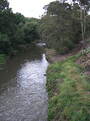
Merri Creek
Encyclopedia
37.759756°N 144.981482°W
The Merri Creek is a waterway in southern parts of Victoria
, Australia
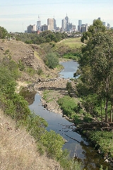
which flows through the northern suburbs of Melbourne
. It begins in Wallan north of Melbourne and flows south for 70km until it joins the Yarra River
at Dights Falls
. The area where the creek meets the river was traditionally the location for large gatherings of the Wurundjeri
people and is suspected to have been the location for one of the earliest land treaties
in Australia
between Indigenous Australians
and European settlers.
The creek was the site of heavy industrial use throughout much of the 20th century, being home to quarries
, landfill
s and accepting waste runoff from neighbouring factories. This has degraded the riparian ecology of the creek leaving behind pollutants such as heavy metals and various grease
s. Recent decades have seen some regenerative planting and the foundation of several community groups dedicated to protecting and regenerating the creek's ecology.
-willam phrase Merri Merri meaning "very rocky", this was later abbreviated to Merri Creek by early European settlers.
 Over 400 million years ago the sea covering the area receded. It left behind a layer of yellowish marine siltstone
and sandstone
rocks. Around 65 million years ago non-marine sediments left a sandy layer behind. Over time the ancestral valley of the Merri Creek developed, eroding through these sediments. Then, from 0.8 to 4.6 million years ago volcanoes such as Hayes Hill (about 5km east of Donnybrook
) and Mt Fraser (near Beveridge
) erupted, sending lava on a journey along the ancestral valleys of the Merri and Darebin Creeks and into the valley of the Yarra River
as far as the CBD.
The modern day Merri Creek was formed over many years, by incising through the lava surface. Today, the creek begins in Wallan north of Melbourne and flows in a southerly direction for 70km until it joins the Yarra River
in Fairfield
near Dights Falls
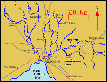
and subsequently flows into Port Phillip Bay. Its tributaries
include; Wallan Creek, Mittagong Creek, Taylors Creek, Malcolm Creek, Aitken Creek, Curly Sedge Creek, Merlynston Creek and Edgars Creek
. It flows through, or forms a part of the borders between the suburbs of Wallan, Kalkallo
, Donnybrook
, Craigieburn
, Wollert
, Epping
, Somerton
, Campbellfield
, Lalor
, Thomastown
, Fawkner
, Reservoir
, Coburg North
, Coburg
, Preston
, Thornbury
, Brunswick East
, Northcote
, Westgarth
, Fitzroy North
, Clifton Hill
and Fairfield
before meeting the Yarra River just upstream of Dights Falls
.
 One of the many sites of geological interest
along the Merri valley is the rocky cliff face on the eastern side of Merri Creek visible from the shared path in Clifton Hill. Its tall, cracked (or jointed) basalt columns, formed by cooling lava, are clearly visible and the weathering evident in the rocky riffles midstream where columns have collapsed and tumbled into the stream. Some of the vertical fractures at the top of the cliff appear to be leaning, forming a striking radial pattern.
s, Kingfishers, Yellow-tailed Black Cockatoo
s, Echidna
s, frog
s and reports of platypus
es in the upper northern regions and now further south in Coburg. Merri Creek is abundant in edible plants for those trained to identify them. Edible species include dandelion, dock, fennel
, jerusalem artichoke
, numerous brassica
s, blackberry nightshade, sorrel
, catsear
, sowthistle, nettle
and many others. Great care in identification should be taken when harvesting fennel and other member of the Apiaceae
family, as Poison hemlock
has been found growing in some areas of the creek.
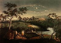
The large number of pre and post-contact archaeological sites demonstrate a heavy usage of the area by Indigenous Australians
. The creek and surrounding valley was the site of many large gatherings of Aboriginal people and is suspected to be the site of one of the earliest land treaties between Aboriginals and Europeans.
 The Wurundjeri-willam were the original occupants of what are now the northern suburbs of Melbourne. Their name comes from the Aboriginal word Wurrun meaning "white gum tree". The Wurundjeri-willam was a clan consisting of a number of extended families. During the first years of contact with Europeans, the Wurundjeri-willam people were represented by influential senior men such as Billibellary, a respected elder. Billibellary’s clan lived on the northern bank of the Yarra and their territory extended from Yarra Bend northwards along the Merri Creek.
The creek supplied the Wurundjeri-willam with an abundance of food such as eel, fish, and duck. Women waded through the Merri with string bags suspended around their neck, searching the bottom of the stream for shellfish. Emu and kangaroo were hunted in the surrounding grasslands. In the forests and hills, possum was also a staple source of food and clothing, The flesh of the possum was cooked and eaten, while the skin was saved to be sewn into valuable waterproof cloaks.
and prominent members of the Wurundjeri-willam and other clans. Billibellary and the other clan elders signed a document, which came to be called Batman's Treaty
, the only treaty ever struck between the European settlers and the indigenous people of Australia. These unique negotiations took place, wrote Batman, by the banks of a "lovely stream of water" which twentieth century historians suspect to be the Merri Creek. This treaty was declared invalid by Sir Richard Bourke, the Governor of N.S.W, who was unwilling to recognize and allow the aborigines the right to use and control their own land as they saw fit.
The largest recorded meeting of Aboriginal people in Victoria occurred at Merri Creek in January 1844. The Wurundjeri-willam hosted an immense gathering of tribes which came from all over central Victoria. An estimated 800 people journeyed to the district to witness important judicial proceedings carried out according to traditions of Aboriginal law.
Since European settlement, the lower reaches of the creek have been seriously degraded by human activity. In the early history of Melbourne, numerous quarries were established along the creek to extract bluestone
for the construction of many of the city's buildings and paving for roads and lanes. These quarries were later used as landfill for waste. Numerous environmental weeds, such as prickly pear
and weeping willows, invaded the banks and stormwater
from suburban streets drains directly into the creek bringing rubbish and other pollutants.
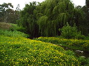
 In recent decades much has been done to remedy the creek's condition. Patches of remnant native flora still remain along the creek, and through weed control and ecological burning their quality has been improved. Much native vegetation has been replanted by the Merri Creek Management Committee and the volunteer group Friends of Merri Creek. In recent years, Melbourne Water
has been involved in a willow
control program to improve water flows and allow for the revegetation of sites with indigenous plant species. At times of low flow, water is sustained in the Creek through treated outfall from the Cragieburn sewage treatment plant, http://www.mcmc.org.au/2004-05.MCMC%20Annual%20Report.pdf. Water quality was thought to have been insufficient to allow repopulation by Platypus
. This is thought to be because toxicants in sediments in the Creek have reduced macroinvertebrate productivity to the point where there is insufficient food to feed a population of platypus. The toxicants are mainly heavy metals and greases which originated in industrial areas in the catchment. However the first sighting in decades occurred between Thornbury and Coburg in Sept 2010.
shared pathway has been established along the banks to take advantage of the improving environment, but the path is broken at Westgarth and North Fitzroy, necessitating traversing St George's Road. Each year, at the CERES Community Environment Park
, the Return of the Kingfisher and Harvest Festivals are celebrated on the banks of the creek.
The Merri Creek is a waterway in southern parts of Victoria
Victoria (Australia)
Victoria is the second most populous state in Australia. Geographically the smallest mainland state, Victoria is bordered by New South Wales, South Australia, and Tasmania on Boundary Islet to the north, west and south respectively....
, Australia
Australia
Australia , officially the Commonwealth of Australia, is a country in the Southern Hemisphere comprising the mainland of the Australian continent, the island of Tasmania, and numerous smaller islands in the Indian and Pacific Oceans. It is the world's sixth-largest country by total area...
which flows through the northern suburbs of Melbourne
Melbourne
Melbourne is the capital and most populous city in the state of Victoria, and the second most populous city in Australia. The Melbourne City Centre is the hub of the greater metropolitan area and the Census statistical division—of which "Melbourne" is the common name. As of June 2009, the greater...
. It begins in Wallan north of Melbourne and flows south for 70km until it joins the Yarra River
Yarra River
The Yarra River, originally Birrarung, is a river in east-central Victoria, Australia. The lower stretches of the river is where the city of Melbourne was established in 1835 and today Greater Melbourne dominates and influences the landscape of its lower reaches...
at Dights Falls
Dights Falls
Dights Falls is located in Melbourne, Victoria just downstream of the junction of the Yarra River with Merri Creek. At this point the river narrows and is constricted between 800,000 year old volcanic, basaltic lava flow and a much older steep, silurian, sedimentary spur...
. The area where the creek meets the river was traditionally the location for large gatherings of the Wurundjeri
Wurundjeri
The Wurundjeri are a people of the Indigenous Australian nation of the Woiwurrung language group, in the Kulin alliance, who occupy the Birrarung Valley, its tributaries and the present location of Melbourne, Australia...
people and is suspected to have been the location for one of the earliest land treaties
Batman's Treaty
Batman's Treaty was a document signed on 6 June 1835 by John Batman, an Australian grazier, businessman and explorer, and a group of Wurundjeri elders, for the purchase of land around Port Phillip, near the present site of the city of Melbourne...
in Australia
Australia
Australia , officially the Commonwealth of Australia, is a country in the Southern Hemisphere comprising the mainland of the Australian continent, the island of Tasmania, and numerous smaller islands in the Indian and Pacific Oceans. It is the world's sixth-largest country by total area...
between Indigenous Australians
Indigenous Australians
Indigenous Australians are the original inhabitants of the Australian continent and nearby islands. The Aboriginal Indigenous Australians migrated from the Indian continent around 75,000 to 100,000 years ago....
and European settlers.
The creek was the site of heavy industrial use throughout much of the 20th century, being home to quarries
Quarry
A quarry is a type of open-pit mine from which rock or minerals are extracted. Quarries are generally used for extracting building materials, such as dimension stone, construction aggregate, riprap, sand, and gravel. They are often collocated with concrete and asphalt plants due to the requirement...
, landfill
Landfill
A landfill site , is a site for the disposal of waste materials by burial and is the oldest form of waste treatment...
s and accepting waste runoff from neighbouring factories. This has degraded the riparian ecology of the creek leaving behind pollutants such as heavy metals and various grease
Fat
Fats consist of a wide group of compounds that are generally soluble in organic solvents and generally insoluble in water. Chemically, fats are triglycerides, triesters of glycerol and any of several fatty acids. Fats may be either solid or liquid at room temperature, depending on their structure...
s. Recent decades have seen some regenerative planting and the foundation of several community groups dedicated to protecting and regenerating the creek's ecology.
Etymology
The creek borrows its name from the WurundjeriWurundjeri
The Wurundjeri are a people of the Indigenous Australian nation of the Woiwurrung language group, in the Kulin alliance, who occupy the Birrarung Valley, its tributaries and the present location of Melbourne, Australia...
-willam phrase Merri Merri meaning "very rocky", this was later abbreviated to Merri Creek by early European settlers.
Geography
Siltstone
Siltstone is a sedimentary rock which has a grain size in the silt range, finer than sandstone and coarser than claystones.- Description :As its name implies, it is primarily composed of silt sized particles, defined as grains 1/16 - 1/256 mm or 4 to 8 on the Krumbein phi scale...
and sandstone
Sandstone
Sandstone is a sedimentary rock composed mainly of sand-sized minerals or rock grains.Most sandstone is composed of quartz and/or feldspar because these are the most common minerals in the Earth's crust. Like sand, sandstone may be any colour, but the most common colours are tan, brown, yellow,...
rocks. Around 65 million years ago non-marine sediments left a sandy layer behind. Over time the ancestral valley of the Merri Creek developed, eroding through these sediments. Then, from 0.8 to 4.6 million years ago volcanoes such as Hayes Hill (about 5km east of Donnybrook
Donnybrook, Victoria
Donnybrook is a bounded rural locality in Victoria, Australia. Its Local Government Area is the City of Whittlesea.It is bounded to the west by Merri Creek and in the east by Darebin Creek.-History:...
) and Mt Fraser (near Beveridge
Beveridge, Victoria
Beveridge is a town in Victoria, Australia, located along the Hume Highway, 42 kilometres north of Melbourne in the Shire of Mitchell. A western rural portion of the locality is within the City of Whittlesea in Greater Melbourne...
) erupted, sending lava on a journey along the ancestral valleys of the Merri and Darebin Creeks and into the valley of the Yarra River
Yarra River
The Yarra River, originally Birrarung, is a river in east-central Victoria, Australia. The lower stretches of the river is where the city of Melbourne was established in 1835 and today Greater Melbourne dominates and influences the landscape of its lower reaches...
as far as the CBD.
The modern day Merri Creek was formed over many years, by incising through the lava surface. Today, the creek begins in Wallan north of Melbourne and flows in a southerly direction for 70km until it joins the Yarra River
Yarra River
The Yarra River, originally Birrarung, is a river in east-central Victoria, Australia. The lower stretches of the river is where the city of Melbourne was established in 1835 and today Greater Melbourne dominates and influences the landscape of its lower reaches...
in Fairfield
Fairfield, Victoria
Fairfield is a suburb in Melbourne, Victoria, Australia, 6 km north-east from Melbourne's central business district. Its Local Government Area are the Cities of Darebin and Yarra...
near Dights Falls
Dights Falls
Dights Falls is located in Melbourne, Victoria just downstream of the junction of the Yarra River with Merri Creek. At this point the river narrows and is constricted between 800,000 year old volcanic, basaltic lava flow and a much older steep, silurian, sedimentary spur...
and subsequently flows into Port Phillip Bay. Its tributaries
Tributary
A tributary or affluent is a stream or river that flows into a main stem river or a lake. A tributary does not flow directly into a sea or ocean...
include; Wallan Creek, Mittagong Creek, Taylors Creek, Malcolm Creek, Aitken Creek, Curly Sedge Creek, Merlynston Creek and Edgars Creek
Edgars Creek Trail
The Edgars Creek Trail is a shared use path for cyclists and pedestrians in the suburb of Thomastown, an inner northern suburb of Melbourne, Victoria.It leads to the historic village of Westgarthtown, which makes for an interesting day out....
. It flows through, or forms a part of the borders between the suburbs of Wallan, Kalkallo
Kalkallo, Victoria
Kalkallo is a town in Victoria, Australia, 33 km north from Melbourne's central business district. Its Local Government Area is the City of Hume....
, Donnybrook
Donnybrook, Victoria
Donnybrook is a bounded rural locality in Victoria, Australia. Its Local Government Area is the City of Whittlesea.It is bounded to the west by Merri Creek and in the east by Darebin Creek.-History:...
, Craigieburn
Craigieburn, Victoria
Craigieburn is a suburb in Melbourne, Victoria, Australia, 26 km north from Melbourne's central business district. Its Local Government Area is the City of Hume. At the 2006 Census, Craigieburn had a population of 20,784....
, Wollert
Wollert, Victoria
Wollert is a town in Melbourne, Victoria, Australia, 27 km north from Melbourne's central business district. Its Local Government Area is the City of Whittlesea. At the 2006 Census, Wollert had a population of 348.-History:...
, Epping
Epping, Victoria
Epping is a suburb in Melbourne, Victoria, Australia, 22 km north from Melbourne's central business district. Its Local Government Area is the City of Whittlesea...
, Somerton
Somerton, Victoria
Somerton is a suburb in Melbourne, Victoria, Australia, 21 km north from Melbourne's central business district. Its Local Government Area is the City of Hume....
, Campbellfield
Campbellfield, Victoria
Campbellfield is a suburb in Melbourne, Victoria, Australia, 16 km north from Melbourne's central business district. Its Local Government Area is the City of Hume. At the 2006 Census, Campbellfield had a population of 5,401.-History:...
, Lalor
Lalor, Victoria
Lalor is a suburb in Melbourne, Victoria, Australia, north of Melbourne's central business district. Its Local Government Area is the City of Whittlesea. At the 2006 Census the suburb had a population of 19,561...
, Thomastown
Thomastown, Victoria
Thomastown is a suburb in Melbourne, Victoria, Australia, 17 km north from Melbourne's central business district. Its Local Government Area is the City of Whittlesea...
, Fawkner
Fawkner, Victoria
Fawkner is a suburb in Melbourne, Victoria, Australia, 12 km north from Melbourne's central business district. Its Local Government Area is the City of Moreland...
, Reservoir
Reservoir, Victoria
Reservoir is a suburb in Melbourne, Victoria, Australia, 12 km north from Melbourne's central business district. Its Local Government Area is the City of Darebin. At the 2006 Census, Reservoir had a population of 45,970....
, Coburg North
Coburg North, Victoria
Coburg North is a suburb in Melbourne, Victoria, Australia, 10 km north from Melbourne's central business district. Its Local Government Area is the City of Moreland. At the 2006 Census, Coburg North had a population of 6064....
, Coburg
Coburg, Victoria
Coburg is a suburb in Melbourne, Victoria, Australia, 8 km north from Melbourne's central business district. Its Local Government Area is the City of Moreland, although a handful of properties on Coburg's Eastern boundary are located in the City of Darebin...
, Preston
Preston, Victoria
Preston is a suburb in Melbourne, Victoria, Australia, 9 km north from Melbourne's central business district. Its Local Government Area is the City of Darebin. At the 2006 Census, Preston had a population of 27,892.-Settlement:...
, Thornbury
Thornbury, Victoria
Thornbury originalSince the 1960s, the vast majority of Melburnians pronounce the name phonetically. The 'h' is no longer silent, and there is more stress placed upon the 'o'. pronunciation is a suburb in Melbourne, Victoria, Australia, 7 km north from Melbourne's central business district....
, Brunswick East
Brunswick East, Victoria
Brunswick East is a suburb in Melbourne, Victoria, Australia, 6 km north from Melbourne's central business district. Its Local Government Area is the City of Moreland. At the 2006 Census, Brunswick East had a population of 7,410....
, Northcote
Northcote, Victoria
Northcote is a suburb in Melbourne, Victoria, Australia, 7 km north-east from Melbourne's central business district. Its Local Government Area is the City of Darebin...
, Westgarth
Westgarth, Victoria
Westgarth is a locality in Melbourne, Victoria, Australia. It is in the Local Government Area of the City of Darebin. It is situated 4 or 5 km from Melbourne's central business district, just north of Clifton Hill, and a few hundred metres south of the main part of Northcote...
, Fitzroy North
Fitzroy North, Victoria
Fitzroy North is a suburb in Melbourne, Victoria, Australia, 4 km north-east from Melbourne's central business district. Its Local Government Area are the Cities of Yarra and Moreland. At the 2006 Census, Fitzroy North had a population of 11,069....
, Clifton Hill
Clifton Hill, Victoria
Clifton Hill is a suburb of Melbourne, Victoria, Australia, 4 km north-east from Melbourne's central business district. The border between Clifton Hill and Fitzroy North is Queens Parade and Smith Street. Merri Creek defines the eastern border of Clifton Hill. Its Local Government Area is...
and Fairfield
Fairfield, Victoria
Fairfield is a suburb in Melbourne, Victoria, Australia, 6 km north-east from Melbourne's central business district. Its Local Government Area are the Cities of Darebin and Yarra...
before meeting the Yarra River just upstream of Dights Falls
Dights Falls
Dights Falls is located in Melbourne, Victoria just downstream of the junction of the Yarra River with Merri Creek. At this point the river narrows and is constricted between 800,000 year old volcanic, basaltic lava flow and a much older steep, silurian, sedimentary spur...
.
Rocky cliff face
along the Merri valley is the rocky cliff face on the eastern side of Merri Creek visible from the shared path in Clifton Hill. Its tall, cracked (or jointed) basalt columns, formed by cooling lava, are clearly visible and the weathering evident in the rocky riffles midstream where columns have collapsed and tumbled into the stream. Some of the vertical fractures at the top of the cliff appear to be leaning, forming a striking radial pattern.
Flora and fauna
As native vegetation has been regenerated, some species of native wildlife has returned to the creek including KookaburraKookaburra
Kookaburras are terrestrial kingfishers native to Australia and New Guinea. They are large to very large, with a total length of . The name is a loanword from Wiradjuri guuguubarra, and is onomatopoeic of its call...
s, Kingfishers, Yellow-tailed Black Cockatoo
Yellow-tailed Black Cockatoo
The Yellow-tailed Black Cockatoo is a large cockatoo native to the south-east of Australia measuring 55–65 cm in length. It has a short crest on the top of its head. Its plumage is mostly brownish black and it has prominent yellow cheek patches and a yellow tail band...
s, Echidna
Echidna
Echidnas , also known as spiny anteaters, belong to the family Tachyglossidae in the monotreme order of egg-laying mammals. There are four extant species, which, together with the platypus, are the only surviving members of that order and are the only extant mammals that lay eggs...
s, frog
Frog
Frogs are amphibians in the order Anura , formerly referred to as Salientia . Most frogs are characterized by a short body, webbed digits , protruding eyes and the absence of a tail...
s and reports of platypus
Platypus
The platypus is a semi-aquatic mammal endemic to eastern Australia, including Tasmania. Together with the four species of echidna, it is one of the five extant species of monotremes, the only mammals that lay eggs instead of giving birth to live young...
es in the upper northern regions and now further south in Coburg. Merri Creek is abundant in edible plants for those trained to identify them. Edible species include dandelion, dock, fennel
Fennel
Fennel is a plant species in the genus Foeniculum . It is a member of the family Apiaceae . It is a hardy, perennial, umbelliferous herb, with yellow flowers and feathery leaves...
, jerusalem artichoke
Jerusalem artichoke
The Jerusalem artichoke , also called the sunroot, sunchoke, earth apple or topinambour, is a species of sunflower native to eastern North America, and found from Eastern Canada and Maine west to North Dakota, and south to northern Florida and Texas...
, numerous brassica
Brassica
Brassica is a genus of plants in the mustard family . The members of the genus may be collectively known either as cabbages, or as mustards...
s, blackberry nightshade, sorrel
Sorrel
Common sorrel or garden sorrel , often simply called sorrel, is a perennial herb that is cultivated as a garden herb or leaf vegetable...
, catsear
Catsear
Catsear , also known as flatweed, cat's ear or false dandelion, is a perennial, low-lying edible herb often found in lawns. The plant is native to Europe, but has also been introduced to the Americas, Japan, Australia and New Zealand where it can be an invasive weed...
, sowthistle, nettle
Nettle
Nettles constitute between 24 and 39 species of flowering plants of the genus Urtica in the family Urticaceae, with a cosmopolitan though mainly temperate distribution. They are mostly herbaceous perennial plants, but some are annual and a few are shrubby...
and many others. Great care in identification should be taken when harvesting fennel and other member of the Apiaceae
Apiaceae
The Apiaceae , commonly known as carrot or parsley family, is a group of mostly aromatic plants with hollow stems. The family is large, with more than 3,700 species spread across 434 genera, it is the sixteenth largest family of flowering plants...
family, as Poison hemlock
Conium
Conium is a genus of two species of highly poisonous perennial herbaceous flowering plants in the family Apiaceae, native to Europe and the Mediterranean region as Conium maculatum, and to southern Africa as Conium chaerophylloides....
has been found growing in some areas of the creek.
History
Indigenous Australians
Indigenous Australians are the original inhabitants of the Australian continent and nearby islands. The Aboriginal Indigenous Australians migrated from the Indian continent around 75,000 to 100,000 years ago....
. The creek and surrounding valley was the site of many large gatherings of Aboriginal people and is suspected to be the site of one of the earliest land treaties between Aboriginals and Europeans.
Archaeology
Many archaeological sites found contain scattered stone artefacts from old campsites, and scarred trees from which traditional people removed slabs of bark to make canoes, containers and shields. The artefact scatters are found because erosion of some sort has exposed the implements which were covered with sediment. The scarred trees are often on the creek bank, fence line or road reserve where they escaped the clearance process. Both site types exhibit traces of the hunting and gathering lifestyle of pre-contact Victoria, and are a fragile and non-renewable historical resource. Aboriginal sites are protected under the Aboriginal Heritage Act 2006.Pre-European
The creek supplied the Wurundjeri-willam with an abundance of food such as eel, fish, and duck. Women waded through the Merri with string bags suspended around their neck, searching the bottom of the stream for shellfish. Emu and kangaroo were hunted in the surrounding grasslands. In the forests and hills, possum was also a staple source of food and clothing, The flesh of the possum was cooked and eaten, while the skin was saved to be sewn into valuable waterproof cloaks.
Post-European
In May 1835 an historic meeting took place between John BatmanJohn Batman
John Batman was an Australian grazier, businessman and explorer who is best known for his role in the founding of a settlement which became Melbourne and the colony of Victoria.-Life:...
and prominent members of the Wurundjeri-willam and other clans. Billibellary and the other clan elders signed a document, which came to be called Batman's Treaty
Batman's Treaty
Batman's Treaty was a document signed on 6 June 1835 by John Batman, an Australian grazier, businessman and explorer, and a group of Wurundjeri elders, for the purchase of land around Port Phillip, near the present site of the city of Melbourne...
, the only treaty ever struck between the European settlers and the indigenous people of Australia. These unique negotiations took place, wrote Batman, by the banks of a "lovely stream of water" which twentieth century historians suspect to be the Merri Creek. This treaty was declared invalid by Sir Richard Bourke, the Governor of N.S.W, who was unwilling to recognize and allow the aborigines the right to use and control their own land as they saw fit.
The largest recorded meeting of Aboriginal people in Victoria occurred at Merri Creek in January 1844. The Wurundjeri-willam hosted an immense gathering of tribes which came from all over central Victoria. An estimated 800 people journeyed to the district to witness important judicial proceedings carried out according to traditions of Aboriginal law.
Since European settlement, the lower reaches of the creek have been seriously degraded by human activity. In the early history of Melbourne, numerous quarries were established along the creek to extract bluestone
Bluestone
Bluestone is a cultural or commercial name for a number of dimension or building stone varieties, including:*a feldspathic sandstone in the U.S. and Canada;*limestone in the Shenandoah Valley in the U.S...
for the construction of many of the city's buildings and paving for roads and lanes. These quarries were later used as landfill for waste. Numerous environmental weeds, such as prickly pear
Opuntia
Opuntia, also known as nopales or paddle cactus , is a genus in the cactus family, Cactaceae.Currently, only prickly pears are included in this genus of about 200 species distributed throughout most of the Americas. Chollas are now separated into the genus Cylindropuntia, which some still consider...
and weeping willows, invaded the banks and stormwater
Stormwater
Stormwater is water that originates during precipitation events. It may also be used to apply to water that originates with snowmelt that enters the stormwater system...
from suburban streets drains directly into the creek bringing rubbish and other pollutants.
Pollution
Melbourne Water
Melbourne Water is a government owned statutory authority that controls much of the water system in Melbourne, Victoria, Australia including the reservoirs, and thesewerage and drainage system that services the city.- Overview :...
has been involved in a willow
Willow
Willows, sallows, and osiers form the genus Salix, around 400 species of deciduous trees and shrubs, found primarily on moist soils in cold and temperate regions of the Northern Hemisphere...
control program to improve water flows and allow for the revegetation of sites with indigenous plant species. At times of low flow, water is sustained in the Creek through treated outfall from the Cragieburn sewage treatment plant, http://www.mcmc.org.au/2004-05.MCMC%20Annual%20Report.pdf. Water quality was thought to have been insufficient to allow repopulation by Platypus
Platypus
The platypus is a semi-aquatic mammal endemic to eastern Australia, including Tasmania. Together with the four species of echidna, it is one of the five extant species of monotremes, the only mammals that lay eggs instead of giving birth to live young...
. This is thought to be because toxicants in sediments in the Creek have reduced macroinvertebrate productivity to the point where there is insufficient food to feed a population of platypus. The toxicants are mainly heavy metals and greases which originated in industrial areas in the catchment. However the first sighting in decades occurred between Thornbury and Coburg in Sept 2010.
Parks and recreation
Parks Victoria manages much of the established parklands on the banks of the creek, facilities include football & cricket ovals, tennis courts and playgrounds. The Merri Creek TrailMerri Creek Trail
The Merri Creek Trail is a shared use path for cyclists and pedestrians, which follows the Merri Creek through the northern suburbs of Melbourne, Victoria, Australia.-Following the Path:...
shared pathway has been established along the banks to take advantage of the improving environment, but the path is broken at Westgarth and North Fitzroy, necessitating traversing St George's Road. Each year, at the CERES Community Environment Park
CERES Community Environment Park
The CERES Community Environment Park, or Centre for Education and Research in Environmental Strategies, is an award-winning urban environmental centre located in urban Brunswick East, Victoria, Australia...
, the Return of the Kingfisher and Harvest Festivals are celebrated on the banks of the creek.