

Survey township
Encyclopedia
United States
The United States of America is a federal constitutional republic comprising fifty states and a federal district...
Public Land Survey System
Public Land Survey System
The Public Land Survey System is a method used in the United States to survey and identify land parcels, particularly for titles and deeds of rural, wild or undeveloped land. Its basic units of area are the township and section. It is sometimes referred to as the rectangular survey system,...
, refers to a square unit of land, that is nominally six (U.S. Survey) miles (~9.7 km) on a side. Each 36 square mile (~93 km²) township is divided into 36 one-square mile (~2.6 km²) sections, that can be further subdivided for sale, and each section covers exactly 640 acres (2.6 km²). To be more precise, the subdivisions of a section are frequently the quarter-section (160 acres) and the quarter-quarter section (40 acres). In the Homestead Act
Homestead Act
A homestead act is one of three United States federal laws that gave an applicant freehold title to an area called a "homestead" – typically 160 acres of undeveloped federal land west of the Mississippi River....
of 1862, one quarter-section of land was the amount allocated to each settler. Stemming from this are the idiomatic expressions, "the lower 40", which is the 40 acres (161,874.4 m²) on a settler's land that is lowest in elevation, in the direction towards which water drains toward a stream, and the "back forty", the portion farthest from the settler's dwelling. The townships are referenced by a numbering system that locates the township in relation to a meridian (north-south) and a base line
Baseline (surveying)
In the United States Public Land Survey System, a baseline is the principal east-west line that divides survey townships between north and south. The baseline meets its corresponding meridian at the point of origin, or initial point, for the land survey...
(east-west). Townships were originally surveyed and platted by the US General Land Office
General Land Office
The General Land Office was an independent agency of the United States government responsible for public domain lands in the United States. It was created in 1812 to take over functions previously conducted by the United States Department of the Treasury...
using contracted private survey crews and are marked on the U.S. Geological Survey topographic maps of the United States of America.
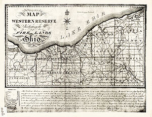
Prior to standardization, some of the Ohio Lands
Ohio Lands
The Ohio Lands were the myriad grants, tracts, districts and cessions which make up what is now the U.S. state of Ohio. The Ohio Country was one of the first settled parts of the Midwest, and indeed one of the first settled parts of the United States beyond the original 13 colonies...
were surveyed into townships of five miles (8 km) on each side. These are often known as Congressional Townships.
Survey townships are distinct from civil township
Civil township
A civil township is a widely used unit of local government in the United States, subordinate to, and geographic divisions of, a county. Specific responsibilities and the degree of autonomy vary based on each state. Civil townships are distinct from survey townships, but in states that have both,...
s. A survey township is used to establish boundaries for land ownership. A civil township is a form of local government
Local government
Local government refers collectively to administrative authorities over areas that are smaller than a state.The term is used to contrast with offices at nation-state level, which are referred to as the central government, national government, or federal government...
. In states that use both forms, civil townships generally use the boundaries established by survey townships. County lines, especially in western States, usually follow township lines, leading to the large number of rectangular counties in the West, which are agglomerations of townships. Other counties may have county lines that form a Jack-O-Lantern tooth pattern of townships.
In western Canada, the Dominion Land Survey
Dominion Land Survey
The Dominion Land Survey is the method used to divide most of Western Canada into one-square-mile sections for agricultural and other purposes. It is based on the layout of the Public Land Survey System used in the United States, but has several differences...
adopted a similar format for survey townships, which do not form administrative units. These townships also have the area of 36 square miles (six miles by six miles).
See also
- Public Land Survey SystemPublic Land Survey SystemThe Public Land Survey System is a method used in the United States to survey and identify land parcels, particularly for titles and deeds of rural, wild or undeveloped land. Its basic units of area are the township and section. It is sometimes referred to as the rectangular survey system,...
- TownshipTownshipThe word township is used to refer to different kinds of settlements in different countries. Township is generally associated with an urban area. However there are many exceptions to this rule. In Australia, the United States, and Canada, they may be settlements too small to be considered urban...
- Township (United States)Township (United States)A township in the United States is a small geographic area. Townships range in size from 6 to 54 square miles , with being the norm.The term is used in three ways....
- Civil townshipCivil townshipA civil township is a widely used unit of local government in the United States, subordinate to, and geographic divisions of, a county. Specific responsibilities and the degree of autonomy vary based on each state. Civil townships are distinct from survey townships, but in states that have both,...