

U.S. Route 50 in Maryland
Encyclopedia
U.S. Route 50 is a major east–west route of the U.S. Highway system, stretching just over 3000 miles (4,828 km) from Ocean City, Maryland
on the Atlantic Ocean to West Sacramento, California
. In the U.S. state
of Maryland
, US 50 exists in two sections. The longer of these serves as a major route connecting Washington, D.C.
with Ocean City; the latter is the eastern terminus of the highway. The other section passes through the southern end of Garrett County
for less than 10 miles (16.1 km) as part of the Northwestern Turnpike
, entering West Virginia
at both ends. One notable section of US 50 is the dual-span Chesapeake Bay Bridge
across Chesapeake Bay
, which links central Maryland with the Eastern Shore region, allowing motorists to reach the beaches of Ocean City and Delaware
.
US 50 has received numerous upgrades during its existence in Maryland, including the building of the John Hanson Highway (which is also the unsigned Interstate 595
), its extension onto the Eastern Shore
and replacement of U.S. Route 213 due to the construction of the Chesapeake Bay Bridge
, and the full dualization of the eastern segment of the route. Many of the older alignments of US 50 are still part of the Maryland and US highway systems, such as U.S. Route 50 Business
in Salisbury, Maryland
. US 50 continues to be upgraded on the Eastern Shore to better accommodate beach travelers and locals alike.
in West Virginia
and enters the state of Maryland in Garrett County
. US 50 is routed along the old Northwestern Turnpike
, presently named George Washington Highway after George Washington
. This section of US 50 is a quiet, rural highway with little traffic, which stands in sharp contrast to the other, longer section. US 50 intersects only two numbered highways along this stretch: US 219
in Red House
, and MD 560
east of there.
Near the West Virginia community of Gormania
, US 50 crosses the Potomac River
and exits Maryland. It then passes through West Virginia
, Virginia
, and the District of Columbia, before reentering Maryland.
.svg.png) US 50 exits the District as the John Hanson Highway, a freeway alignment extended from the east end of New York Avenue in Prince George's County. It instantly interchanges with the Baltimore-Washington Parkway
US 50 exits the District as the John Hanson Highway, a freeway alignment extended from the east end of New York Avenue in Prince George's County. It instantly interchanges with the Baltimore-Washington Parkway
at a hybrid interchange with a full cloverleaf
and partial-Y elements. The B-W Parkway also allows access to Maryland Route 201
. The freeway parallels the Orange Line
of the Washington Metro
as it weaves through the suburban area, interchanging with Maryland Route 202
and Maryland Route 410
, then passes over the Orange Line and the New Carrollton Metro Station access road Maryland Route 950. It then meets a hybrid turbine interchange with Interstate 95 and 495, the Capital Beltway.
East of the interchange, US 50 enters the Interstate Highway System as the unsigned Interstate 595. The route is 10 lanes wide; beyond the MD 704
interchange, it narrows to eight lanes, with the innermost two being HOV lanes. Up to and slightly beyond the US 301
/MD 3
interchange, the road surface is concrete; the roadway beyond there is asphalt. Within the US 301 interchange, the HOV lanes that began at the Capital Beltway come to an end, and US 301 joins US 50 and I-595, forming a three-route concurrency.
The central portion of the route runs through undeveloped forest and parkland, meeting Maryland Route 424
three miles (5 km) east of US 301. After meeting Interstate 97
, the carriageways from I-97 straddle US 50 for a short distance before becoming MD 665
, continuing toward downtown Annapolis as a direct freeway spur.
The route now runs through the Annapolis urban area, meeting MD 450 and MD 2. Continuing southeast, the route (which is now a four-route concurrency of US 50, US 301, I-595 and MD 2) eventually reaches the MD 70
interchange, where I-595 officially terminates.
, bearing this as its name past the MD 70 interchange. The route then passes over the Pearl Harbor Memorial Bridge over the Severn River
and interchanges with the eastern end of MD 450. This interchanges also releases MD 2 from the concurrency, which travels northward to Baltimore. The US 50 and US 301 freeway pass through heavily wooded area, interchanging with few routes and offering rest stops along its final stretch through the Western Shore region. The freeway then interchanges with one last road, Oceanic Road, which passes over the toll plaza for the Chesapeake Bay Bridge
.
The bridge's official name is the William Preston Lane, Jr. Memorial Bridge, and it connects Sandy Point on the Western Shore with Kent Island on the Eastern Shore. The bridge's asymmetrical dual spans are also a point of traffic congestion
. The bridge raises US 50 and US 301 over two shipping channels, marked by the suspension and the through-truss spans of the structure. The bridge brings the two routes down on Kent Island, and quickly after, interchanges with Maryland Route 8
at a diamond interchange
. After this interchange, the freeway portion on the Island continues, interchanging with many streets with sharp right-in/right-out
ramps, until it meets the Kent Narrows Bridge, raising the routes over the Kent Narrows
and bringing them down on the Eastern Shore's mainland.
Most of the interchanges along the final stretch of the freeway give access to Maryland Route 18
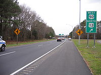
, which parallels US 50 and 301 as a local route and a former alignment of the highway. After interchanging with Nesbit Road at another diamond interchange and the routes approach Queenstown
, development ceases, and US 50 and US 301 separate at a half-trumpet interchange. US 301 continues straight along the carriageways, retaining the Blue Star Memorial Highway designation all the way to the Delaware
state line. US 50, however, turns south using the ramps, and it picks up a new name: the Ocean Gateway.
 The Ocean Gateway name for US 50 is retained mostly for the remainder of its routing, changing only twice more for short distances. Continuing east from the US 50 and US 301 split, the highway becomes a four-lane, dual highway and instantly intersects Maryland Route 18
for the last time. It continues through open farmland, bearing southeast as it passes the northern terminus of Maryland Route 662
and Maryland Route 213
, both former routings of the highway, which straddle Chesapeake College
. US 50 then makes a curve, aiming almost perfectly south as it meets Maryland Route 404
atop the Queen Anne's/Talbot border.
 US 50 continues to be signed as east/west, although it follows a north/south path. MD 662 weaves back and forth through open farmlands across this alignment through Talbot County as it approaches Easton
, sometimes merging with it as well. North of Easton, Maryland Route 322
leaves US 50 to the west, which functions as a bypass of the town. US 50 passes east of the center of town, the speed limit dropping from 55MPH to 35MPH as it passes through the commercial sector. Outside of town, MD 322 meets US 50, and Maryland Route 565
runs concurrent with US 50 at the same intersection. MD 565 is another former alignment of US 50, possessing the residential development in the southern Talbot area. US 50 continues by Trappe
, meeting the southern end of MD 565 before continuing to the Choptank River
.
and Dorchester County
, the speed limit once again dropping to 35 mi/h, as the route returns to an east-west alignment. The entire section of US 50 in the city of Cambridge is named Sunburst Highway; this name is carried until Woods Road at the corporate boundaries of Cambridge. Here, the route's name returns to The Ocean Gateway, and later it picks up a concurrency with Maryland Route 16
for a short while outside the city, which ends in East New Market. From here, US 50 travels through mostly rural countryside in Dorchester County with several loops of older alignments of US 50 crossing the highway. As it dodges around Vienna
on the Nanticoke River
, the route intersects Old Ocean Gateway as a direct spur into the town. This road, formerly US 50 and then formerly MD 731, utilized a drawbridge to cross the river before the Nanticoke Memorial Bridge and Vienna Bypass opened in 1991. US 50 then interchanges with Maryland Route 331
at a partial cloverleaf and rises onto the Nanticoke Memorial Bridge, passing over the Nanticoke River.
 US 50 then enters Wicomico County, and soon after passes by Mardela Springs
. As it does so, it intersects Maryland Route 313
and Maryland Route 54. The route continues through open farmland in a general southeastern alignment until it approaches Salisbury
. Northwest of the city, US 50 diverges onto the Salisbury Bypass, a freeway bypass forming a 3/4 beltway around the city. At this junction is US 50 Business
, which goes directly through Salisbury. The Salisbury Bypass soon after interchanges with Naylor Mill Road, which allows westbound Business US 50 traffic to enter the freeway eastbound. The Bypass then passes through the Northwood business park on an earthen viaduct within the city limits, interchanging partially with Northwood Drive to grant access. Soon after this, US 50 interchanges with US 13
and Business US 13
, picking up a concurrency with mainline US 13.
The two routes circle around the city to the northeast and eventually meet the interchange with US 13 and US 50 Business at a partial cloverleaf. Here, US 50 leaves the Bypass, and bears east along a four-lane, divided alignment. It passes by the campus of Wor-Wic Community College
and continues through open farmland once more, intersecting various routes as it parallels MD 346 and bypasses Parsonsburg
, Pittsville
, and Willards
, to the Pocomoke River
, where the route leaves the county.
branches off to the north, bypassing the town of Berlin
and bearing toward the northern part of Ocean City, Shortly after MD 90, MD 346 crosses US 50 and heads into downtown Berlin. US 50 passes through northern Berlin, and meets a full cloverleaf interchange with US 113 in the process. This interchange also features railroad tracks, which cross two of the ramps. The route meets the end of MD 346 and continues through the heavily developed West Ocean City, Maryland
, weaving across older alignments, notably Maryland Route 707
. Maryland Route 589
also intersects the route, which leads to Ocean Pines
and the last interchange with MD 90. US 50 finally passes over the Harry W. Kelly Memorial Bridge
and the Sinepuxent Bay
, touching down in the town of Ocean City, and meeting its national eastern terminus.
 Although the route's ceremonial eastern terminus is at Maryland Route 528
, Philadelphia Avenue, eastbound US 50 actually continues past MD 528 as North Division Street and ends at Maryland Route 378, Baltimore Avenue, a short distance from the Atlantic Ocean
and Ocean City Boardwalk. From the westbound lanes as of June 2009, a sign can be seen displaying the distance to Sacramento, California as 3073 miles. This is an incorrect measure which is shared on California's end of US 50
, as the route's length has been adjusted many times and shortened.
. It ended at Church Circle in Annapolis
, near St. Anne's Church
. Beyond the end of US 50 was a ferry which connected the route to what was then Maryland Route 17
on the Eastern Shore, in Talbot County.
 Just before the Chesapeake Bay Bridge's
completion, in 1948, the route was extended to Ocean City
. This extension brought the route across the bay via an existing ferry
service, and US 50 replaced much of U.S. Route 213 and portions of Maryland Route 404
on the Eastern Shore
. As a result of US 50 being routed onto the Eastern Shore, US 213 north of what is now US 50 was removed from the U.S. Highway system, and became the current Maryland Route 213
by the late 1970s. Once the bridge was completed in 1952, it replaced the ferry, which had been in service since the 1930s.
The John Hanson Highway, named for John Hanson
, was the first section of US 50 to be upgraded to a freeway in Maryland. It was completed soon after the Bay Bridge was built, and the older alignment was redesignated Maryland Route 450
. A slight extension of MD 450 was then created to reconnect it with US 50 near the present-day intersection with Maryland Route 2
.
and Maryland Route 322
. In Salisbury, US 50 was moved from Main Street to Church Street. In Worcester County, its present-day alignment was created, though only dualized east of US 113 in Berlin. Following this, in the mid-1960s, a new four-lane section of US 50 was completed between Salisbury at then-US 13 and Berlin at US 113, its old alignment east of East Main Street becoming Maryland Route 346
, and Church Street being returned to the city. The rest of US 50 on the Eastern Shore was in the process of being dualized. This included an adjacent span of the Chesapeake Bay Bridge being built in 1973, widening the thoroughfare to an asymmetrical five lanes.
In 1991, just as the final two-lane section of US 50 was falling into severe disrepair, Vienna
was bypassed to the northeast, completing the dualization of US 50 in Maryland. The old road was turned over to Wicomico County on its side (then privatized to Delmarva Power and Light
in 2007), and the Dorchester street through Vienna became Maryland Route 731. Also at this time, two extra lanes were added to the John Hanson Highway in both directions as the Interstate 595 section was designated. Some overhead signs on and near the route do include space for the Interstate 595 shield, but the shields were never installed in order to reduce motorist confusion. The freeway portion was continued over to the Eastern Shore, from the Chesapeake Bay Bridge east to the US 50-301 split in Queenstown
. The US 50/301 portion of the Blue Star Memorial Highway was upgraded to a freeway mostly during the late 1980s and early 1990s; prior to this it was only a divided highway
with several local roads intersecting it. After being upgraded, many of these intersections became sharp right-in/right-out
ramps.
The most recent upgrade to US 50 came in October 2002, when the Salisbury Bypass was extended to circle the north side of the city. US 50 was rerouted onto this, and the alignment within the city, already bypassed numerous times, became present-day US 50 Business.
atop the Queen Anne's/Talbot County border. This comes along with plans to fully dualize the latter highway in the state of Maryland.
Ocean City, Maryland
Ocean City, sometimes known as OC, or OCMD, is an Atlantic Ocean resort town in Worcester County, Maryland, United States. Ocean City is widely known in the Mid-Atlantic region of the United States and is a frequent destination for vacationers in that area...
on the Atlantic Ocean to West Sacramento, California
West Sacramento, California
West Sacramento is a city in Yolo County, California. It is contiguous with Sacramento, but is separated by the Sacramento River which is also the county line, so West Sacramento is in a different county than Sacramento...
. In the U.S. state
U.S. state
A U.S. state is any one of the 50 federated states of the United States of America that share sovereignty with the federal government. Because of this shared sovereignty, an American is a citizen both of the federal entity and of his or her state of domicile. Four states use the official title of...
of Maryland
Maryland
Maryland is a U.S. state located in the Mid Atlantic region of the United States, bordering Virginia, West Virginia, and the District of Columbia to its south and west; Pennsylvania to its north; and Delaware to its east...
, US 50 exists in two sections. The longer of these serves as a major route connecting Washington, D.C.
Washington, D.C.
Washington, D.C., formally the District of Columbia and commonly referred to as Washington, "the District", or simply D.C., is the capital of the United States. On July 16, 1790, the United States Congress approved the creation of a permanent national capital as permitted by the U.S. Constitution....
with Ocean City; the latter is the eastern terminus of the highway. The other section passes through the southern end of Garrett County
Garrett County, Maryland
Garrett County is the westernmost county of the U.S. state of Maryland. Created from Allegany County, Maryland in 1872 it was the last Maryland county to be formed. It was named for John Work Garrett , railroad executive, industrialist, and financier. Garrett served as president of the Baltimore...
for less than 10 miles (16.1 km) as part of the Northwestern Turnpike
Northwestern Turnpike
The Northwestern Turnpike is a historic road in West Virginia , important for being historically one of the major roads crossing the Appalachians, financed by the Virginia Board of Public Works in the 1830s. In modern times, west of Winchester, Virginia, U.S...
, entering West Virginia
West Virginia
West Virginia is a state in the Appalachian and Southeastern regions of the United States, bordered by Virginia to the southeast, Kentucky to the southwest, Ohio to the northwest, Pennsylvania to the northeast and Maryland to the east...
at both ends. One notable section of US 50 is the dual-span Chesapeake Bay Bridge
Chesapeake Bay Bridge
The Chesapeake Bay Bridge is a major dual-span bridge in the U.S. state of Maryland. Spanning the Chesapeake Bay, it connects the state's rural Eastern Shore region with the more urban Western Shore. The original span opened in 1952 and, at the time, with a length of , it was the world's longest...
across Chesapeake Bay
Chesapeake Bay
The Chesapeake Bay is the largest estuary in the United States. It lies off the Atlantic Ocean, surrounded by Maryland and Virginia. The Chesapeake Bay's drainage basin covers in the District of Columbia and parts of six states: New York, Pennsylvania, Delaware, Maryland, Virginia, and West...
, which links central Maryland with the Eastern Shore region, allowing motorists to reach the beaches of Ocean City and Delaware
Delaware
Delaware is a U.S. state located on the Atlantic Coast in the Mid-Atlantic region of the United States. It is bordered to the south and west by Maryland, and to the north by Pennsylvania...
.
US 50 has received numerous upgrades during its existence in Maryland, including the building of the John Hanson Highway (which is also the unsigned Interstate 595
Interstate 595 (Maryland)
Interstate 595 is an unsigned number for a section of the John Hanson Highway from Interstate 495 east of Washington, D.C. to Maryland Route 70 at Annapolis, Maryland....
), its extension onto the Eastern Shore
Eastern Shore of Maryland
The Eastern Shore of Maryland is a territorial part of the U.S. state of Maryland that lies predominately on the east side of the Chesapeake Bay and consists of nine counties. The origin of term Eastern Shore was derived to distinguish a territorial part of the State of Maryland from the Western...
and replacement of U.S. Route 213 due to the construction of the Chesapeake Bay Bridge
Chesapeake Bay Bridge
The Chesapeake Bay Bridge is a major dual-span bridge in the U.S. state of Maryland. Spanning the Chesapeake Bay, it connects the state's rural Eastern Shore region with the more urban Western Shore. The original span opened in 1952 and, at the time, with a length of , it was the world's longest...
, and the full dualization of the eastern segment of the route. Many of the older alignments of US 50 are still part of the Maryland and US highway systems, such as U.S. Route 50 Business
U.S. Route 50 Business (Salisbury, Maryland)
U.S. Route 50 Business is a business route of U.S. Route 50 in the U.S. state of Maryland. The highway runs between US 50 on the northwest side of Salisbury and US 50 on the east side of Salisbury, the county seat of Wicomico County...
in Salisbury, Maryland
Salisbury, Maryland
-Demographics:Salisbury is the principal city of the Salisbury-Ocean Pines CSA, a Combined Statistical Area that includes the Salisbury metropolitan area and the Ocean Pines micropolitan area , which had a combined population of 176,657 at the 2010 census.As of the census of 2000, there were...
. US 50 continues to be upgraded on the Eastern Shore to better accommodate beach travelers and locals alike.
George Washington Highway
US 50 leaves Preston CountyPreston County, West Virginia
As of the census of 2000, there were 29,334 people, 11,544 households, and 8,357 families residing in the county. The population density was 45 people per square mile . There were 13,444 housing units at an average density of 21 per square mile...
in West Virginia
West Virginia
West Virginia is a state in the Appalachian and Southeastern regions of the United States, bordered by Virginia to the southeast, Kentucky to the southwest, Ohio to the northwest, Pennsylvania to the northeast and Maryland to the east...
and enters the state of Maryland in Garrett County
Garrett County, Maryland
Garrett County is the westernmost county of the U.S. state of Maryland. Created from Allegany County, Maryland in 1872 it was the last Maryland county to be formed. It was named for John Work Garrett , railroad executive, industrialist, and financier. Garrett served as president of the Baltimore...
. US 50 is routed along the old Northwestern Turnpike
Northwestern Turnpike
The Northwestern Turnpike is a historic road in West Virginia , important for being historically one of the major roads crossing the Appalachians, financed by the Virginia Board of Public Works in the 1830s. In modern times, west of Winchester, Virginia, U.S...
, presently named George Washington Highway after George Washington
George Washington
George Washington was the dominant military and political leader of the new United States of America from 1775 to 1799. He led the American victory over Great Britain in the American Revolutionary War as commander-in-chief of the Continental Army from 1775 to 1783, and presided over the writing of...
. This section of US 50 is a quiet, rural highway with little traffic, which stands in sharp contrast to the other, longer section. US 50 intersects only two numbered highways along this stretch: US 219
U.S. Route 219 in Maryland
U.S. Route 219 is a part of the U.S. Highway System that runs from Rich Creek, Virginia to West Seneca, New York. In the U.S. state of Maryland, the federal highway runs from the West Virginia state line near Red House to the Pennsylvania state line near Grantsville...
in Red House
Red House, Maryland
Red House is an unincorporated community in Garrett County, Maryland, United States, located at the intersection of U.S. Route 50 and U.S. Route 219 near the West Virginia state line....
, and MD 560
Maryland Route 560
Maryland Route 560 is a state highway in the U.S. state of Maryland. Known for most of its length as Gorman Road, the state highway runs from U.S. Route 50 in Gorman north to MD 135 in Mountain Lake Park. MD 560 serves as the main street of Loch Lynn Heights...
east of there.
Near the West Virginia community of Gormania
Gormania, West Virginia
Gormania is an unincorporated community along the North Branch Potomac River in Grant County, West Virginia. Gormania lies on the Northwestern Turnpike , which crosses the North Branch into Gorman, Maryland via Gormania Bridge. It is named for United States Senator from Maryland, Arthur P. Gorman...
, US 50 crosses the Potomac River
Potomac River
The Potomac River flows into the Chesapeake Bay, located along the mid-Atlantic coast of the United States. The river is approximately long, with a drainage area of about 14,700 square miles...
and exits Maryland. It then passes through West Virginia
West Virginia
West Virginia is a state in the Appalachian and Southeastern regions of the United States, bordered by Virginia to the southeast, Kentucky to the southwest, Ohio to the northwest, Pennsylvania to the northeast and Maryland to the east...
, Virginia
Virginia
The Commonwealth of Virginia , is a U.S. state on the Atlantic Coast of the Southern United States. Virginia is nicknamed the "Old Dominion" and sometimes the "Mother of Presidents" after the eight U.S. presidents born there...
, and the District of Columbia, before reentering Maryland.
John Hanson Highway
Baltimore-Washington Parkway
The Baltimore–Washington Parkway is a highway in the U.S. state of Maryland, running southwest from Baltimore to Washington, D.C. The road begins at an interchange with U.S. Route 50 and Maryland Route 201 near Cheverly in Prince George's County at the D.C...
at a hybrid interchange with a full cloverleaf
Cloverleaf interchange
A cloverleaf interchange is a two-level interchange in which left turns, reverse direction in left-driving regions, are handled by ramp roads...
and partial-Y elements. The B-W Parkway also allows access to Maryland Route 201
Maryland Route 201
-Route description:MD 201 begins at a large hybrid cloverleaf just outside the D.C. boundary at Tuxedo, Maryland that is maintained by the Maryland State Highway Administration...
. The freeway parallels the Orange Line
Orange Line (Washington Metro)
The Orange Line of the Washington Metro consists of 26 rapid transit stations from Vienna to New Carrollton. It has stations in Fairfax County and Arlington, Virginia, the District of Columbia, and Prince George's County, Maryland. Half of the line's stations are shared with the Blue Line, and over...
of the Washington Metro
Washington Metro
The Washington Metro, commonly called Metro, and unofficially Metrorail, is the rapid transit system in Washington, D.C., United States, and its surrounding suburbs. It is administered by the Washington Metropolitan Area Transit Authority , which also operates Metrobus service under the Metro name...
as it weaves through the suburban area, interchanging with Maryland Route 202
Maryland Route 202
Maryland Route 202 is a north–south state highway in Prince George's County within the U.S. state of Maryland. MD 202 travels through many communities in central Prince George's County, and is known as Maryland Route 202 (MD 202) is a north–south state highway in Prince George's...
and Maryland Route 410
Maryland Route 410
Maryland Route 410 is a state highway in the U.S. state of Maryland. Known for most of its length as East–West Highway, the highway runs from MD 355 in Bethesda east to Pennsy Drive in Landover Hills...
, then passes over the Orange Line and the New Carrollton Metro Station access road Maryland Route 950. It then meets a hybrid turbine interchange with Interstate 95 and 495, the Capital Beltway.
East of the interchange, US 50 enters the Interstate Highway System as the unsigned Interstate 595. The route is 10 lanes wide; beyond the MD 704
Maryland Route 704
Maryland Route 704 is a state highway in the U.S. state of Maryland. Known as Martin Luther King Jr. Highway, the state highway runs from Eastern Avenue at the District of Columbia boundary in Seat Pleasant east to MD 450 in Lanham....
interchange, it narrows to eight lanes, with the innermost two being HOV lanes. Up to and slightly beyond the US 301
U.S. Route 301 in Maryland
U.S. Route 301 in Maryland is a major highway that runs from Delaware to the Governor Harry W. Nice Memorial Bridge into Virginia. It passes through three of Maryland's four main regions: the Eastern Shore, the Baltimore-Washington Metropolitan Area, and Southern Maryland...
/MD 3
Maryland Route 3
Maryland Route 3, also part of Robert Crain Highway, is the designation given to the former alignment of U.S. Route 301 from Bowie, Maryland, USA, to Baltimore. It is named for Robert Crain of Baltimore.-Route description:...
interchange, the road surface is concrete; the roadway beyond there is asphalt. Within the US 301 interchange, the HOV lanes that began at the Capital Beltway come to an end, and US 301 joins US 50 and I-595, forming a three-route concurrency.
The central portion of the route runs through undeveloped forest and parkland, meeting Maryland Route 424
Maryland Route 424
Maryland Route 424 is a state highway in the U.S. state of Maryland. Known as Davidsonville Road, the state highway runs from MD 214 in Davidsonville north to MD 3 in Crofton.-Route description:...
three miles (5 km) east of US 301. After meeting Interstate 97
Interstate 97
Interstate 97 is an intrastate Interstate Highway located entirely within Anne Arundel County, Maryland, United States. It runs from Annapolis at the overlapped section of US 50, US 301, and the unsigned I-595 to Baltimore at the city's beltway...
, the carriageways from I-97 straddle US 50 for a short distance before becoming MD 665
Maryland Route 665
Maryland Route 665 is a state highway in the U.S. state of Maryland. Known as Aris T. Allen Boulevard, the state highway runs from unsigned Interstate 595 , U.S...
, continuing toward downtown Annapolis as a direct freeway spur.
The route now runs through the Annapolis urban area, meeting MD 450 and MD 2. Continuing southeast, the route (which is now a four-route concurrency of US 50, US 301, I-595 and MD 2) eventually reaches the MD 70
Maryland Route 70
Maryland Route 70 is a state highway in Annapolis, Maryland.-Route description:Maryland Route 70 begins at an intersection with Maryland Route 450 in downtown Annapolis, following the dual Bladen Street at its southern beginning. After a few blocks, Rowe Boulevard merges into Bladen Street, and...
interchange, where I-595 officially terminates.
Blue Star Memorial Highway
US 50 now becomes a Blue Star Memorial HighwayBlue Star Memorial Highway
Blue Star Memorial Highways are highways in the United States that are marked to pay tribute to the U.S. armed forces. The National Council of State Garden Clubs, now known as National Garden Clubs, Inc., started the program in 1945 after World War II. The blue star was used on service flags to...
, bearing this as its name past the MD 70 interchange. The route then passes over the Pearl Harbor Memorial Bridge over the Severn River
Severn River (Maryland)
The Severn River runs through Anne Arundel County in the U.S. state of Maryland. It is located south of the Magothy River, and north of the South River.-Geography:...
and interchanges with the eastern end of MD 450. This interchanges also releases MD 2 from the concurrency, which travels northward to Baltimore. The US 50 and US 301 freeway pass through heavily wooded area, interchanging with few routes and offering rest stops along its final stretch through the Western Shore region. The freeway then interchanges with one last road, Oceanic Road, which passes over the toll plaza for the Chesapeake Bay Bridge
Chesapeake Bay Bridge
The Chesapeake Bay Bridge is a major dual-span bridge in the U.S. state of Maryland. Spanning the Chesapeake Bay, it connects the state's rural Eastern Shore region with the more urban Western Shore. The original span opened in 1952 and, at the time, with a length of , it was the world's longest...
.
The bridge's official name is the William Preston Lane, Jr. Memorial Bridge, and it connects Sandy Point on the Western Shore with Kent Island on the Eastern Shore. The bridge's asymmetrical dual spans are also a point of traffic congestion
Traffic congestion
Traffic congestion is a condition on road networks that occurs as use increases, and is characterized by slower speeds, longer trip times, and increased vehicular queueing. The most common example is the physical use of roads by vehicles. When traffic demand is great enough that the interaction...
. The bridge raises US 50 and US 301 over two shipping channels, marked by the suspension and the through-truss spans of the structure. The bridge brings the two routes down on Kent Island, and quickly after, interchanges with Maryland Route 8
Maryland Route 8
Maryland Route 8 is a state highway in the U.S. state of Maryland. Known for most of its length as Romancoke Road, the state highway runs from Romancoke Pier in Romancoke north to MD 18 in Stevensville. MD 8 is the main north–south highway of Kent Island in western Queen Anne's County. ...
at a diamond interchange
Diamond interchange
A diamond interchange is a common type of road junction, used where a freeway crosses a minor road. The freeway itself is grade-separated from the minor road, one crossing the other over a bridge...
. After this interchange, the freeway portion on the Island continues, interchanging with many streets with sharp right-in/right-out
Right-in/right-out
Right-in/right-out and left-in/left-out refer to a type of road intersection where turning movements of vehicles are restricted. A RIRO permits only right turns and a LILO permits only left turns. RIRO is usual where vehicles drive on the right, and LILO is usual where vehicles drive on the left...
ramps, until it meets the Kent Narrows Bridge, raising the routes over the Kent Narrows
Kent Narrows
The Kent Narrows, also known as Kent Island Narrows and to local residents simply as the Narrows, is a waterway that connects the Chester River with the Eastern Bay and also separates Kent Island from the Delmarva Peninsula. It runs through the community of Kent Narrows, Maryland. The Kent...
and bringing them down on the Eastern Shore's mainland.
Most of the interchanges along the final stretch of the freeway give access to Maryland Route 18
Maryland Route 18
Maryland Route 18 is a state highway in the U.S. state of Maryland. The state highway runs from the beginning of state maintenance at Love Point east to MD 213 in Centreville...
, which parallels US 50 and 301 as a local route and a former alignment of the highway. After interchanging with Nesbit Road at another diamond interchange and the routes approach Queenstown
Queenstown, Maryland
Queenstown is a town in Queen Anne's County, Maryland, United States. The population was 617 at the 2000 census.-Geography:Queenstown is located at ....
, development ceases, and US 50 and US 301 separate at a half-trumpet interchange. US 301 continues straight along the carriageways, retaining the Blue Star Memorial Highway designation all the way to the Delaware
Delaware
Delaware is a U.S. state located on the Atlantic Coast in the Mid-Atlantic region of the United States. It is bordered to the south and west by Maryland, and to the north by Pennsylvania...
state line. US 50, however, turns south using the ramps, and it picks up a new name: the Ocean Gateway.
Queen Anne's County
Maryland Route 18
Maryland Route 18 is a state highway in the U.S. state of Maryland. The state highway runs from the beginning of state maintenance at Love Point east to MD 213 in Centreville...
for the last time. It continues through open farmland, bearing southeast as it passes the northern terminus of Maryland Route 662
Maryland Route 662
Maryland Route 662 is a collection of state highways in the U.S. state of Maryland. These highways are sections of old alignment of U.S. Route 50 between Easton and Wye Mills in Talbot County and Queen Anne's County. MD 662C runs from Easton to Longwoods. MD 662B runs from Longwoods to...
and Maryland Route 213
Maryland Route 213
Maryland Route 213 is a state highway located on the Eastern Shore of Maryland in the United States. The route runs from Maryland Route 662 in Wye Mills, Queen Anne's County north to the Pennsylvania border in Cecil County, where it continues into that state as Pennsylvania Route 841...
, both former routings of the highway, which straddle Chesapeake College
Chesapeake College
Chesapeake College is a two-year college that provides an A.A. degree with its primary campus located in Wye Mills, Maryland, at the intersection of U.S. Route 50 and Maryland Route 213. It serves five Mid-Shore counties: Caroline, Dorchester, Kent, Queen Anne's, and Talbot. Its mascot is the...
. US 50 then makes a curve, aiming almost perfectly south as it meets Maryland Route 404
Maryland Route 404
Maryland Route 404 is a major highway on Maryland's Eastern Shore in the United States. It runs from Maryland Route 662 in Wye Mills on the border of Queen Anne's and Talbot Counties, southeast to the Delaware state line in Caroline County, where the road continues as Delaware Route 404 to Nassau...
atop the Queen Anne's/Talbot border.
Talbot County
Easton, Maryland
Easton, founded 1710, is a town within the Easton District of Talbot County, Maryland, United States. The population was 11,708 at the 2000 census, and 14,677 according to current July 2008 census estimates. It is the county seat of Talbot County. The primary ZIP Code is 21601, and the...
, sometimes merging with it as well. North of Easton, Maryland Route 322
Maryland Route 322
Maryland Route 322 is a state highway in the U.S. state of Maryland. Known as Easton Parkway, the highway runs on the west side of Easton between two junctions with U.S. Route 50...
leaves US 50 to the west, which functions as a bypass of the town. US 50 passes east of the center of town, the speed limit dropping from 55MPH to 35MPH as it passes through the commercial sector. Outside of town, MD 322 meets US 50, and Maryland Route 565
Maryland Route 565
Maryland Route 565 is a collection of state highways in the U.S. state of Maryland. These three highways are sections of old alignment of U.S. Route 213, the predecessor route to US 50, between Trappe and Easton. MD 565 runs from Trappe to US 50 south of Easton. MD 565A is a section of...
runs concurrent with US 50 at the same intersection. MD 565 is another former alignment of US 50, possessing the residential development in the southern Talbot area. US 50 continues by Trappe
Trappe, Maryland
Trappe is a town in Talbot County, Maryland, United States. The population was 1,146 at the 2000 census. The local telephone exchange is 476 and the area code is 410. The zipcode is 21673....
, meeting the southern end of MD 565 before continuing to the Choptank River
Choptank River
The Choptank River is a major tributary of the Chesapeake Bay on the Delmarva Peninsula. Running for , it rises in Kent County, Delaware, runs through Caroline County, Maryland and forms much of the border between Talbot County, Maryland on the north, and Caroline County and Dorchester County on...
.
Dorchester County
US 50 then passes over the Senator Frederick C. Malkus Bridge and enters CambridgeCambridge, Maryland
Cambridge is a city in Dorchester County, Maryland, United States. The population was 12,326 at the 2010 census. It is the county seat of Dorchester County and the county's largest municipality...
and Dorchester County
Dorchester County, Maryland
Dorchester County is a county located in the U.S. state of Maryland on its Eastern Shore. It is bordered by the Choptank River to the north, Talbot County to the northwest, Caroline County to the northeast, Wicomico County to the southeast, Sussex County, Delaware, to the east, and the Chesapeake...
, the speed limit once again dropping to 35 mi/h, as the route returns to an east-west alignment. The entire section of US 50 in the city of Cambridge is named Sunburst Highway; this name is carried until Woods Road at the corporate boundaries of Cambridge. Here, the route's name returns to The Ocean Gateway, and later it picks up a concurrency with Maryland Route 16
Maryland Route 16
Maryland Route 16 is a state highway in the U.S. state of Maryland. The state highway runs from Taylors Island east to the Delaware state line in Hickman, where the highway continues as Delaware Route 16...
for a short while outside the city, which ends in East New Market. From here, US 50 travels through mostly rural countryside in Dorchester County with several loops of older alignments of US 50 crossing the highway. As it dodges around Vienna
Vienna, Maryland
Vienna is a town in Dorchester County, Maryland, United States. The population was 280 at the 2000 census.-History:Vienna was founded in 1706. It thrived on trade, shipbuilding and tobacco farming. Throughout the next century, the British would raid the town repeatedly, and also during the War of...
on the Nanticoke River
Nanticoke River
The Nanticoke River is a major tributary of the Chesapeake Bay on the Delmarva Peninsula. It rises in southern Kent County, Delaware, flows through Sussex County, Delaware, and forms the boundary between Dorchester County, Maryland and Wicomico County, Maryland. The river course proceeds southwest...
, the route intersects Old Ocean Gateway as a direct spur into the town. This road, formerly US 50 and then formerly MD 731, utilized a drawbridge to cross the river before the Nanticoke Memorial Bridge and Vienna Bypass opened in 1991. US 50 then interchanges with Maryland Route 331
Maryland Route 331
Maryland Route 331 is a state highway on the Eastern Shore of Maryland in the United States. The route runs from Vienna in Dorchester County northwest to Easton in Talbot County, intersecting U.S. Route 50 at both ends. MD 331 is a two-lane undivided road most of its length that passes mostly...
at a partial cloverleaf and rises onto the Nanticoke Memorial Bridge, passing over the Nanticoke River.
Wicomico County
Mardela Springs, Maryland
Mardela Springs is a town in Wicomico County, Maryland, United States. The population was 364 at the 2000 census. It is included in the Salisbury, Maryland Metropolitan Statistical Area.-Geography:Mardela Springs is located at ....
. As it does so, it intersects Maryland Route 313
Maryland Route 313
Maryland Route 313 is a state highway located on the Eastern Shore of Maryland in the United States. The route runs from U.S. Route 50 in Mardela Springs, Wicomico County north to Maryland Route 213 and Maryland Route 290 in Galena, Kent County...
and Maryland Route 54. The route continues through open farmland in a general southeastern alignment until it approaches Salisbury
Salisbury, Maryland
-Demographics:Salisbury is the principal city of the Salisbury-Ocean Pines CSA, a Combined Statistical Area that includes the Salisbury metropolitan area and the Ocean Pines micropolitan area , which had a combined population of 176,657 at the 2010 census.As of the census of 2000, there were...
. Northwest of the city, US 50 diverges onto the Salisbury Bypass, a freeway bypass forming a 3/4 beltway around the city. At this junction is US 50 Business
U.S. Route 50 Business (Salisbury, Maryland)
U.S. Route 50 Business is a business route of U.S. Route 50 in the U.S. state of Maryland. The highway runs between US 50 on the northwest side of Salisbury and US 50 on the east side of Salisbury, the county seat of Wicomico County...
, which goes directly through Salisbury. The Salisbury Bypass soon after interchanges with Naylor Mill Road, which allows westbound Business US 50 traffic to enter the freeway eastbound. The Bypass then passes through the Northwood business park on an earthen viaduct within the city limits, interchanging partially with Northwood Drive to grant access. Soon after this, US 50 interchanges with US 13
U.S. Route 13 in Maryland
U.S. Route 13 is a U.S. Highway running from Fayetteville, North Carolina north to Morrisville, Pennsylvania. In the U.S. state of Maryland, the route runs from the Virginia border south of Pocomoke City in Worcester County north to the Delaware border in Delmar, Wicomico County, where the route...
and Business US 13
U.S. Route 13 Business (Salisbury, Maryland)
U.S. Route 13 Business is a business route of U.S. Route 13 in the U.S. state of Maryland. The highway runs between US 13 south of Fruitland and US 13 and US 50 on the north side of Salisbury...
, picking up a concurrency with mainline US 13.
The two routes circle around the city to the northeast and eventually meet the interchange with US 13 and US 50 Business at a partial cloverleaf. Here, US 50 leaves the Bypass, and bears east along a four-lane, divided alignment. It passes by the campus of Wor-Wic Community College
Wor-Wic Community College
-Tuition:Tuition is $81 per credit hour for residents of Wicomico, Worcester, and Somerset counties, $197 per credit hour for other Maryland residents, and $239 per credit hour for out-of-state students.-External links:*...
and continues through open farmland once more, intersecting various routes as it parallels MD 346 and bypasses Parsonsburg
Parsonsburg, Maryland
Parsonsburg is an unincorporated community in Wicomico County, Maryland, United States.-References:...
, Pittsville
Pittsville, Maryland
Pittsville is a town in Wicomico County, Maryland, United States. The population was 1,182 at the 2000 census. It is included in the Salisbury, Maryland Metropolitan Statistical Area.-Geography:Pittsville is located at ....
, and Willards
Willards, Maryland
Willards is a town in Wicomico County, Maryland, United States. The population was 938 at the 2000 census. It is included in the Salisbury, Maryland Metropolitan Statistical Area.-Geography:...
, to the Pocomoke River
Pocomoke River
The Pocomoke River stretches approximately from southern Delaware through southeastern Maryland in the United States. At its mouth, the river is essentially an arm of Chesapeake Bay, whereas the upper river flows through a series of relatively inaccessible wetlands called the Great Cypress Swamp,...
, where the route leaves the county.
Worcester County
Shortly after entering the county, Maryland Route 90Maryland Route 90
Maryland Route 90 is a state highway in the U.S. state of Maryland. Known as the Ocean City Expressway, the state highway runs from U.S. Route 50 near Whaleyville to MD 528 in Ocean City. MD 90 is a two-lane expressway that provides one of the main access routes to Ocean City, especially the...
branches off to the north, bypassing the town of Berlin
Berlin, Maryland
Berlin is a town in Worcester County, Maryland, United States. The population was 3,491 at the 2000 census.-History:The town of Berlin had its start around the 1790s, part of the Burley Plantation, a land grant dating back to 1677...
and bearing toward the northern part of Ocean City, Shortly after MD 90, MD 346 crosses US 50 and heads into downtown Berlin. US 50 passes through northern Berlin, and meets a full cloverleaf interchange with US 113 in the process. This interchange also features railroad tracks, which cross two of the ramps. The route meets the end of MD 346 and continues through the heavily developed West Ocean City, Maryland
West Ocean City, Maryland
West Ocean City is a census-designated place in Worcester County, Maryland, United States. The population was 3,311 at the 2000 census.-Geography:West Ocean City is located at ....
, weaving across older alignments, notably Maryland Route 707
Maryland Route 707
Maryland Route 707 is a collection of state highways in the Maryland Route 707 is a collection of [[state highway|state highways]] in the...
. Maryland Route 589
Maryland Route 589
Maryland Route 589 is a state highway in the U.S. state of Maryland. Known as Racetrack Road, the state highway runs from U.S. Route 50 in Grays Corner north to US 113 and MD 575 in Showell. MD 589 provides access to the planned community of Ocean Pines and harness racing venue Ocean Downs,...
also intersects the route, which leads to Ocean Pines
Ocean Pines, Maryland
Ocean Pines is a census-designated place in Worcester County, Maryland, United States. The population was 11,710 at the 2010 census. It is the principal of and is included in the Ocean Pines, Maryland Micropolitan Statistical Area, which is included in the Salisbury-Ocean Pines, Maryland Combined...
and the last interchange with MD 90. US 50 finally passes over the Harry W. Kelly Memorial Bridge
Harry W. Kelly Memorial Bridge
The Harry W. Kelley Memorial Bridge is a bridge in the U.S. state of Maryland. It carries 4 lanes of U.S. Route 50, plus two sidewalks, across Sinepuxent Bay, connecting the downtown area of Ocean City, Maryland to the mainland of Worcester County, Maryland within West Ocean City, and is mere feet...
and the Sinepuxent Bay
Sinepuxent Bay
Sinepuxent Bay is an inland waterway which connects Chincoteague Bay to the Ocean City Inlet. It separates Sinepuxent Neck, in Worcester County, Maryland, from Assateague Island, and is crossed by the Verrazano Bridge on Maryland State Highway 611 Sinepuxent Bay is an inland waterway which connects...
, touching down in the town of Ocean City, and meeting its national eastern terminus.
Maryland Route 528
Maryland Route 528 is a state highway in the U.S. state of Maryland. Known for most of its length as Coastal Highway, the state highway runs from the southern terminus of its companion route, unsigned Maryland Route 378, in downtown Ocean City north to the Delaware state line at the northern...
, Philadelphia Avenue, eastbound US 50 actually continues past MD 528 as North Division Street and ends at Maryland Route 378, Baltimore Avenue, a short distance from the Atlantic Ocean
Atlantic Ocean
The Atlantic Ocean is the second-largest of the world's oceanic divisions. With a total area of about , it covers approximately 20% of the Earth's surface and about 26% of its water surface area...
and Ocean City Boardwalk. From the westbound lanes as of June 2009, a sign can be seen displaying the distance to Sacramento, California as 3073 miles. This is an incorrect measure which is shared on California's end of US 50
U.S. Route 50 in California
In the U.S. state of California, U.S. Route 50 runs east from I-80 in West Sacramento to the Nevada state line in South Lake Tahoe. Portions within Sacramento are known as the Capital City Freeway and El Dorado Freeway...
, as the route's length has been adjusted many times and shortened.
History
While the portion of U.S. 50 in Garrett County has remained largely unchanged, the eastern portion has changed significantly since the route was established in 1926.Original 1926 plan
On the Western Shore, US 50 was on the alignment currently known as Maryland Route 450Maryland Route 450
Maryland Route 450 is a state highway in the U.S. state of Maryland. The state highway runs from U.S. Route 1 Alternate in Bladensburg east to US 50, US 301, and MD 2 near Annapolis. MD 450 is the original alignment of US 50 in Prince George's and Anne Arundel Counties...
. It ended at Church Circle in Annapolis
Annapolis, Maryland
Annapolis is the capital of the U.S. state of Maryland, as well as the county seat of Anne Arundel County. It had a population of 38,394 at the 2010 census and is situated on the Chesapeake Bay at the mouth of the Severn River, south of Baltimore and about east of Washington, D.C. Annapolis is...
, near St. Anne's Church
St. Anne's Church (Annapolis, Maryland)
St. Anne's Episcopal Church is a historic Episcopal church located in Church Circle, Annapolis. The first church in Annapolis, it was founded in 1692 to serve as the parish church for the newly created Middle Neck Parish, one of the original 30 Anglican parishes in the Province of Maryland.-First...
. Beyond the end of US 50 was a ferry which connected the route to what was then Maryland Route 17
Maryland Route 33
Maryland Route 33 is a state highway in the U.S. state of Maryland. The state highway runs from Tilghman Island east to Washington Street in Easton...
on the Eastern Shore, in Talbot County.
Extension to the Eastern Shore
Chesapeake Bay Bridge
The Chesapeake Bay Bridge is a major dual-span bridge in the U.S. state of Maryland. Spanning the Chesapeake Bay, it connects the state's rural Eastern Shore region with the more urban Western Shore. The original span opened in 1952 and, at the time, with a length of , it was the world's longest...
completion, in 1948, the route was extended to Ocean City
Ocean City, Maryland
Ocean City, sometimes known as OC, or OCMD, is an Atlantic Ocean resort town in Worcester County, Maryland, United States. Ocean City is widely known in the Mid-Atlantic region of the United States and is a frequent destination for vacationers in that area...
. This extension brought the route across the bay via an existing ferry
Ferry
A ferry is a form of transportation, usually a boat, but sometimes a ship, used to carry primarily passengers, and sometimes vehicles and cargo as well, across a body of water. Most ferries operate on regular, frequent, return services...
service, and US 50 replaced much of U.S. Route 213 and portions of Maryland Route 404
Maryland Route 404
Maryland Route 404 is a major highway on Maryland's Eastern Shore in the United States. It runs from Maryland Route 662 in Wye Mills on the border of Queen Anne's and Talbot Counties, southeast to the Delaware state line in Caroline County, where the road continues as Delaware Route 404 to Nassau...
on the Eastern Shore
Eastern Shore of Maryland
The Eastern Shore of Maryland is a territorial part of the U.S. state of Maryland that lies predominately on the east side of the Chesapeake Bay and consists of nine counties. The origin of term Eastern Shore was derived to distinguish a territorial part of the State of Maryland from the Western...
. As a result of US 50 being routed onto the Eastern Shore, US 213 north of what is now US 50 was removed from the U.S. Highway system, and became the current Maryland Route 213
Maryland Route 213
Maryland Route 213 is a state highway located on the Eastern Shore of Maryland in the United States. The route runs from Maryland Route 662 in Wye Mills, Queen Anne's County north to the Pennsylvania border in Cecil County, where it continues into that state as Pennsylvania Route 841...
by the late 1970s. Once the bridge was completed in 1952, it replaced the ferry, which had been in service since the 1930s.
The John Hanson Highway, named for John Hanson
John Hanson
John Hanson was a merchant and public official from Maryland during the era of the American Revolution. After serving in a variety of roles for the Patriot cause in Maryland, in 1779 Hanson was elected as a delegate to the Continental Congress...
, was the first section of US 50 to be upgraded to a freeway in Maryland. It was completed soon after the Bay Bridge was built, and the older alignment was redesignated Maryland Route 450
Maryland Route 450
Maryland Route 450 is a state highway in the U.S. state of Maryland. The state highway runs from U.S. Route 1 Alternate in Bladensburg east to US 50, US 301, and MD 2 near Annapolis. MD 450 is the original alignment of US 50 in Prince George's and Anne Arundel Counties...
. A slight extension of MD 450 was then created to reconnect it with US 50 near the present-day intersection with Maryland Route 2
Maryland Route 2
Maryland Route 2 is the longest state highway in the U.S. state of Maryland. The route runs from Solomons Island in Calvert County north to an intersection with U.S. Route 1 and U.S. Route 40 Truck in Baltimore...
.
Dualization of US 50
High volumes of beach traffic as a result of the Chesapeake Bay Bridge called for further upgrades to the route. A very straight alignment south through Talbot County was later created, the old routing becoming Maryland Route 662Maryland Route 662
Maryland Route 662 is a collection of state highways in the U.S. state of Maryland. These highways are sections of old alignment of U.S. Route 50 between Easton and Wye Mills in Talbot County and Queen Anne's County. MD 662C runs from Easton to Longwoods. MD 662B runs from Longwoods to...
and Maryland Route 322
Maryland Route 322
Maryland Route 322 is a state highway in the U.S. state of Maryland. Known as Easton Parkway, the highway runs on the west side of Easton between two junctions with U.S. Route 50...
. In Salisbury, US 50 was moved from Main Street to Church Street. In Worcester County, its present-day alignment was created, though only dualized east of US 113 in Berlin. Following this, in the mid-1960s, a new four-lane section of US 50 was completed between Salisbury at then-US 13 and Berlin at US 113, its old alignment east of East Main Street becoming Maryland Route 346
Maryland Route 346
Maryland Route 346 is a state highway in the U.S. state of Maryland. The state highway runs from U.S. Route 50 Business in Salisbury east to US 50 in Berlin...
, and Church Street being returned to the city. The rest of US 50 on the Eastern Shore was in the process of being dualized. This included an adjacent span of the Chesapeake Bay Bridge being built in 1973, widening the thoroughfare to an asymmetrical five lanes.
In 1991, just as the final two-lane section of US 50 was falling into severe disrepair, Vienna
Vienna, Maryland
Vienna is a town in Dorchester County, Maryland, United States. The population was 280 at the 2000 census.-History:Vienna was founded in 1706. It thrived on trade, shipbuilding and tobacco farming. Throughout the next century, the British would raid the town repeatedly, and also during the War of...
was bypassed to the northeast, completing the dualization of US 50 in Maryland. The old road was turned over to Wicomico County on its side (then privatized to Delmarva Power and Light
Pepco Holdings
Pepco Holdings, Inc. is a holding company incorporated in February of 2001 for the purpose of effecting the acquisition of Conectiv Power Delivery by Potomac Electric Power Company . The acquisition was completed on August 1, 2002 at which time Pepco and Conectiv became wholly owned subsidiaries...
in 2007), and the Dorchester street through Vienna became Maryland Route 731. Also at this time, two extra lanes were added to the John Hanson Highway in both directions as the Interstate 595 section was designated. Some overhead signs on and near the route do include space for the Interstate 595 shield, but the shields were never installed in order to reduce motorist confusion. The freeway portion was continued over to the Eastern Shore, from the Chesapeake Bay Bridge east to the US 50-301 split in Queenstown
Queenstown, Maryland
Queenstown is a town in Queen Anne's County, Maryland, United States. The population was 617 at the 2000 census.-Geography:Queenstown is located at ....
. The US 50/301 portion of the Blue Star Memorial Highway was upgraded to a freeway mostly during the late 1980s and early 1990s; prior to this it was only a divided highway
Dual carriageway
A dual carriageway is a class of highway with two carriageways for traffic travelling in opposite directions separated by a central reservation...
with several local roads intersecting it. After being upgraded, many of these intersections became sharp right-in/right-out
Right-in/right-out
Right-in/right-out and left-in/left-out refer to a type of road intersection where turning movements of vehicles are restricted. A RIRO permits only right turns and a LILO permits only left turns. RIRO is usual where vehicles drive on the right, and LILO is usual where vehicles drive on the left...
ramps.
The most recent upgrade to US 50 came in October 2002, when the Salisbury Bypass was extended to circle the north side of the city. US 50 was rerouted onto this, and the alignment within the city, already bypassed numerous times, became present-day US 50 Business.
Future
There are currently plans to upgrade US 50 in Queen Anne's County to a full limited access freeway, the freeway portion ending at an interchange with Maryland Route 404Maryland Route 404
Maryland Route 404 is a major highway on Maryland's Eastern Shore in the United States. It runs from Maryland Route 662 in Wye Mills on the border of Queen Anne's and Talbot Counties, southeast to the Delaware state line in Caroline County, where the road continues as Delaware Route 404 to Nassau...
atop the Queen Anne's/Talbot County border. This comes along with plans to fully dualize the latter highway in the state of Maryland.
Points of interest
- Severn River Bridge in Annapolis (rededicated as the Pearl Harbor Memorial Bridge in December, 2006)
- US Naval Academy (has its own exit off US 50)
- Chesapeake Bay BridgeChesapeake Bay BridgeThe Chesapeake Bay Bridge is a major dual-span bridge in the U.S. state of Maryland. Spanning the Chesapeake Bay, it connects the state's rural Eastern Shore region with the more urban Western Shore. The original span opened in 1952 and, at the time, with a length of , it was the world's longest...
- Kent IslandKent Island, MarylandKent Island is the largest island in the Chesapeake Bay, and a historic place in Maryland. To the east, a narrow channel known as the Kent Narrows barely separates the island from the Delmarva Peninsula, and on the other side, the island is separated from Sandy Point, an area near Annapolis, by...
(site of the oldest EnglishEnglandEngland is a country that is part of the United Kingdom. It shares land borders with Scotland to the north and Wales to the west; the Irish Sea is to the north west, the Celtic Sea to the south west, with the North Sea to the east and the English Channel to the south separating it from continental...
settlement in Maryland) - Kent Narrows Bridge between Kent Island and GrasonvilleGrasonville, MarylandGrasonville is a census-designated place in Queen Anne's County, Maryland, United States. The population was 2,193 at the 2000 census.-Geography:Grasonville is located at ....
- Frederick C. Malkus Bridge in Cambridge
- Nanticoke River Memorial Bridge in ViennaVienna, MarylandVienna is a town in Dorchester County, Maryland, United States. The population was 280 at the 2000 census.-History:Vienna was founded in 1706. It thrived on trade, shipbuilding and tobacco farming. Throughout the next century, the British would raid the town repeatedly, and also during the War of...
- Harry W. Kelly Memorial BridgeHarry W. Kelly Memorial BridgeThe Harry W. Kelley Memorial Bridge is a bridge in the U.S. state of Maryland. It carries 4 lanes of U.S. Route 50, plus two sidewalks, across Sinepuxent Bay, connecting the downtown area of Ocean City, Maryland to the mainland of Worcester County, Maryland within West Ocean City, and is mere feet...
in Ocean CityOcean City, MarylandOcean City, sometimes known as OC, or OCMD, is an Atlantic Ocean resort town in Worcester County, Maryland, United States. Ocean City is widely known in the Mid-Atlantic region of the United States and is a frequent destination for vacationers in that area... - Ocean City Boardwalk, near the eastern terminus
Junction list
Exits are numbered from west to east, in accordance with AASHTO guidelines.| County | Location | Mile | Exit Exit number An exit number is a number assigned to a road junction, usually an exit from a freeway. It is usually marked on the same sign as the destinations of the exit, as well as a sign in the gore.... |
Destinations | Notes |
|---|---|---|---|---|---|
| West Virginia West Virginia West Virginia is a state in the Appalachian and Southeastern regions of the United States, bordered by Virginia to the southeast, Kentucky to the southwest, Ohio to the northwest, Pennsylvania to the northeast and Maryland to the east... state line |
|||||
| Garrett Garrett County, Maryland Garrett County is the westernmost county of the U.S. state of Maryland. Created from Allegany County, Maryland in 1872 it was the last Maryland county to be formed. It was named for John Work Garrett , railroad executive, industrialist, and financier. Garrett served as president of the Baltimore... 9.17 miles (14.76 km) |
Red House Red House, Maryland Red House is an unincorporated community in Garrett County, Maryland, United States, located at the intersection of U.S. Route 50 and U.S. Route 219 near the West Virginia state line.... |
2.1 | Former MD 37 | ||
| 9.1 | – Mountain Lake Park Mountain Lake Park Mountain Lake Park is a San Francisco park in the Richmond District neighborhood, located north of the intersection of Lake and Funston. It was designed by engineer William Hammond Hall in the late 19th century, circa 1875. Hall also designed Golden Gate Park and was significantly influenced by... |
||||
| US 50 exits and reenters Maryland Maryland Maryland is a U.S. state located in the Mid Atlantic region of the United States, bordering Virginia, West Virginia, and the District of Columbia to its south and west; Pennsylvania to its north; and Delaware to its east... via West Virginia West Virginia West Virginia is a state in the Appalachian and Southeastern regions of the United States, bordered by Virginia to the southeast, Kentucky to the southwest, Ohio to the northwest, Pennsylvania to the northeast and Maryland to the east... , Virginia Virginia The Commonwealth of Virginia , is a U.S. state on the Atlantic Coast of the Southern United States. Virginia is nicknamed the "Old Dominion" and sometimes the "Mother of Presidents" after the eight U.S. presidents born there... , and District of Columbia |
|||||
| Prince George's Prince George's County, Maryland Prince George's County is a county located in the U.S. state of Maryland, immediately north, east, and south of Washington, DC. As of 2010, it has a population of 863,420 and is the wealthiest African-American majority county in the nation.... 14.39 miles (23.16 km) |
Cheverly Cheverly, Maryland Cheverly is a town in central Maryland, just outside Washington, D.C., United States. The town was founded in 1918 and it was incorporated in 1931. Cheverly had 6,433 residents as of the 2000 Census.... |
0.2 | eastbound exit, westbound entrance; B-W Parkway joins westbound and splits eastbound |
||
| 0.5 |    MD 201 MD 201Maryland Route 201 -Route description:MD 201 begins at a large hybrid cloverleaf just outside the D.C. boundary at Tuxedo, Maryland that is maintained by the Maryland State Highway Administration... south (Kenilworth Avenue) to DC 295/I-295 Interstate 295 (District of Columbia) Interstate 295 in the U.S. state of Maryland and in Washington, D.C. is a spur route connecting I-95/I-495 and Maryland Route 210 on the Potomac River to Interstate 695 in downtown Washington.-Route description:Although I-295 technically begins at the Capital Beltway , a pair of mainline... – Kenilworth, Washington, D.C. Kenilworth, Washington, D.C. Kenilworth is a residential neighborhood in Northeast Washington, D.C., located on the eastern bank of the Anacostia River and just inside the D.C.-Maryland border. A large public housing complex, Kenilworth Courts, dominates the area... |
||||
| 0.5 | |||||
| 1.6 | , Metro Station Cheverly (Washington Metro) Cheverly is a side platformed Washington Metro station in Cheverly, Maryland, United States. The station was opened on November 20, 1978, and is operated by the Washington Metropolitan Area Transit Authority . Providing service for the Orange Line, the station is the first station going east in... |
eastbound exit, westbound entrance | |||
| Landover Landover, Maryland Landover is an unincorporated community in Prince George's County, Maryland, United States, within the census-designated place of Greater Landover. The Prince Georges County Sports and Learning Complex is in Landover... |
2.8 | ||||
| Landover Hills Landover Hills, Maryland Landover Hills is a town in Prince George's County, Maryland, United States. The population was 1,534 at the 2000 census.It has a neighborhood named Defense Heights.-Bordering areas:* Woodlawn * Greater Landover... |
4.1 | 5 | |||
| New Carrollton New Carrollton, Maryland New Carrollton is a city located in central Prince George's County, Maryland, in the United States. As of the 2000 census, population was 12,589.New Carrollton is 12.11 miles from central Washington, DC.... |
4.5 |  US 50PA (Ardwick-Ardmore Road) – New Carrollton Station US 50PA (Ardwick-Ardmore Road) – New Carrollton StationNew Carrollton (Washington Metro) New Carrollton rail station is a joint Washington Metro, MARC, and Amtrak station in New Carrollton, Prince George's County, Maryland at the eastern end of the Orange Line and planned Purple Line, and adjacent to the Capital Beltway. The Amtrak waiting room is located beneath the Metro station... |
westbound exit; road is unsigned spur of US 50 |
||
| 5.0 | 7 | , Richmond Richmond, Virginia Richmond is the capital of the Commonwealth of Virginia, in the United States. It is an independent city and not part of any county. Richmond is the center of the Richmond Metropolitan Statistical Area and the Greater Richmond area... |
Signed as exits 7A (south) and 7B (north) Western terminus of unsigned I-595 Interstate 595 (Maryland) Interstate 595 is an unsigned number for a section of the John Hanson Highway from Interstate 495 east of Washington, D.C. to Maryland Route 70 at Annapolis, Maryland.... |
||
| 6.1 | 8 | ||||
| Bowie Bowie, Maryland Bowie is a city in Prince George's County, Maryland, United States. The population was 54,727 at the 2010 census. Bowie has grown from a small railroad stop to the largest municipality in Prince George's County, and the fifth most populous city and third largest city by area in the state of... |
11.7 | 11 | |||
| 13.1 | 13 | Signed as exits 13A (US 301 south), 13B (MD 3 north) and 13C (Belair Drive) West end of US 301 overlap |
|||
| Anne Arundel Anne Arundel County, Maryland Anne Arundel County is a county located in the U.S. state of Maryland. It is named for Anne Arundell , a member of the ancient family of Arundells in Cornwall, England and the wife of Cæcilius Calvert, 2nd Baron Baltimore. Its county seat is Annapolis, which is also the capital of the state... 19.88 miles (31.99 km) |
16.5 | 16 | |||
| Annapolis Annapolis, Maryland Annapolis is the capital of the U.S. state of Maryland, as well as the county seat of Anne Arundel County. It had a population of 38,394 at the 2010 census and is situated on the Chesapeake Bay at the mouth of the Severn River, south of Baltimore and about east of Washington, D.C. Annapolis is... |
21.2 | 21 | |||
| 23.0 | 22 | ||||
| 23.5 | 23 | West end of MD 2 overlap | |||
| 24.8 | 24A-B | Signed as exits 24A (MD 70 south) and 24B (Bestgate Road) westbound Eastern terminus of unsigned I-595 Interstate 595 (Maryland) Interstate 595 is an unsigned number for a section of the John Hanson Highway from Interstate 495 east of Washington, D.C. to Maryland Route 70 at Annapolis, Maryland.... |
|||
| Pearl Harbor Memorial Bridge over Severn River Severn River (Maryland) The Severn River runs through Anne Arundel County in the U.S. state of Maryland. It is located south of the Magothy River, and north of the South River.-Geography:... |
|||||
| Arnold Arnold, Maryland Arnold is a census-designated place in Anne Arundel County, Maryland, United States. The population was 23,422 at the 2000 census. Neighborhoods straddle College Parkway and Ritchie Highway. Arnold is located on the scenic Broadneck peninsula... |
26.7 | 27 | , Naval Academy United States Naval Academy The United States Naval Academy is a four-year coeducational federal service academy located in Annapolis, Maryland, United States... |
Signed as exits 27A (MD 450 south) and 27B (MD 2 north) westbound; East end of MD 2 overlap |
|
| direct turnoff from westbound carriageway | |||||
| 27.6 | 28 | Bay Dale Drive – Bay Hills Golf Club | |||
| 29.2 | 29 | Signed as exits 29A (MD 179) and 29B (Cape St. Claire Road) eastbound | |||
| Sandy Point | 30.6 | 31 | direct turnoff from eastbound carriageway | ||
| 31.4 | 32 | – Sandy Point State Park Sandy Point State Park Sandy Point State Park is a Maryland state park located at Sandy Point, at the western end of the Chesapeake Bay Bridge in Anne Arundel County, Maryland. The park is at the site of a former ferry landing that served the Chesapeake Bay Ferry System... |
|||
| Chesapeake Bay Bridge Chesapeake Bay Bridge The Chesapeake Bay Bridge is a major dual-span bridge in the U.S. state of Maryland. Spanning the Chesapeake Bay, it connects the state's rural Eastern Shore region with the more urban Western Shore. The original span opened in 1952 and, at the time, with a length of , it was the world's longest... over Chesapeake Bay Chesapeake Bay The Chesapeake Bay is the largest estuary in the United States. It lies off the Atlantic Ocean, surrounded by Maryland and Virginia. The Chesapeake Bay's drainage basin covers in the District of Columbia and parts of six states: New York, Pennsylvania, Delaware, Maryland, Virginia, and West... |
|||||
| Queen Anne's Queen Anne's County, Maryland Queen Anne's County is a county located on the Eastern Shore of the U.S. state of Maryland.As of 2010, the population was 47,798. Its county seat and most populous municipality is Centreville. The census-designated place of Stevensville is the county's most populous place... 18.78 miles (30.22 km) |
Stevensville Stevensville, Maryland Stevensville is a census-designated place in Queen Anne's County, Maryland, and is the county's most populous place among both CDPs and municipalities. The Stevensville Historic District is one of only two registered historic districts in the county, the other being the Centreville Historic... |
37.2 | 37 | ||
| 37.9 | 38A | Thomspon Creek Rd: roundabout Roundabout A roundabout is the name for a road junction in which traffic moves in one direction around a central island. The word dates from the early 20th century. Roundabouts are common in many countries around the world... on ramp, eastbound exit and entrance; Duke Street: westbound entrance and exit (right-in/right-out Right-in/right-out Right-in/right-out and left-in/left-out refer to a type of road intersection where turning movements of vehicles are restricted. A RIRO permits only right turns and a LILO permits only left turns. RIRO is usual where vehicles drive on the right, and LILO is usual where vehicles drive on the left... ) |
|||
| 38.9 | 38B | Shopping Center Road to Main Street | westbound entrance and exit | ||
| 39.0 | 39A | Castle Marina Rd: westbound entrance and exit; Cox Neck Rd: eastbound exit and entrance |
|||
| Chester Chester, Maryland Chester is a census-designated place on Kent Island in Queen Anne's County, Maryland, United States. The population was 3,723 at the 2000 census.-Geography:Chester is located at .... |
39.5 | 39B | MD 552: eastbound exit and entrance; Chester Station Ln: westbound entrance and exit |
||
| 40.1 | 40A | Piney Creek Road | right-in/right-out Right-in/right-out Right-in/right-out and left-in/left-out refer to a type of road intersection where turning movements of vehicles are restricted. A RIRO permits only right turns and a LILO permits only left turns. RIRO is usual where vehicles drive on the right, and LILO is usual where vehicles drive on the left... entrance/exit |
||
| 40.5 | 40B | Dundee Avenue | eastbound exit and entrance | ||
| Kent Narrows Kent Narrows, Maryland Kent Narrows is a census-designated place and town in Queen Anne's County, Maryland, United States. As of the 2000 census, the town had a population of 567.-Geography:Kent Narrows is located at .... |
40.8 | 41 | MD 18: eastbound exit and entrance; Piney Narrows Rd: westbound entrance and exit |
||
| Kent Narrows Bridge over Kent Narrows Kent Narrows The Kent Narrows, also known as Kent Island Narrows and to local residents simply as the Narrows, is a waterway that connects the Chester River with the Eastern Bay and also separates Kent Island from the Delmarva Peninsula. It runs through the community of Kent Narrows, Maryland. The Kent... |
|||||
| 41.9 | 42 | MD 18: eastbound entrance and exit; MD 835: westbound entrance and exit |
|||
| Grasonville Grasonville, Maryland Grasonville is a census-designated place in Queen Anne's County, Maryland, United States. The population was 2,193 at the 2000 census.-Geography:Grasonville is located at .... |
42.8 | 43A | MD 18: eastbound entrance and exit; MD 835: westbound entrance and exit |
||
| 43.4 | 43B | westbound entrance; eastbound entrance and exit | |||
| 43.8 | 44A | Station Ln: eastbound exit and entrance; VFW Ave: westbound entrance and exit |
|||
| 44.2 | 44B | MD 835: westbound entrance and exit; Evans Ave: eastbound exit and entrance |
|||
| 44.5 | 45A | Homeport Dr: westbound entrance and exit; Hess Rd: eastbound exit and entrance | |||
| 44.9 | 45B | ||||
| Queenstown Queenstown, Maryland Queenstown is a town in Queen Anne's County, Maryland, United States. The population was 617 at the 2000 census.-Geography:Queenstown is located at .... |
46.1 | 46 | , Wilmington DE Wilmington, Delaware Wilmington is the largest city in the state of Delaware, United States, and is located at the confluence of the Christina River and Brandywine Creek, near where the Christina flows into the Delaware River. It is the county seat of New Castle County and one of the major cities in the Delaware Valley... |
eastbound exit and westbound entrance; East end of US 301 overlap |
|
| East end of expressway section | |||||
| Queenstown Queenstown, Maryland Queenstown is a town in Queen Anne's County, Maryland, United States. The population was 617 at the 2000 census.-Geography:Queenstown is located at .... |
46.3 | ||||
| 47.7 | |||||
| 49.1 | Carmichael Road | ||||
| 50.7 | Former US 50 | ||||
| Wye Mills Wye Mills, Maryland Wye Mills is an unincorporated community in Talbot County, Maryland, United States, located at an altitude of 13 feet . It is the home of the Wye Grist Mill which has been in nearly continuous operation since 1682, and Wye Oak and of Chesapeake College.-References:... |
51.6 | Former US 213 | |||
| 53.1 | , Rehoboth Rehoboth Beach, Delaware Rehoboth Beach is a city in Sussex County, Delaware, United States. According to the 2010 census, the population is 1,327, a decrease of 11.2% from 2000... |
||||
| Talbot Talbot County, Maryland -2010:Whereas according to the 2010 U.S. Census Bureau:*81.4% White*12.8% Black*0.2% Native American*1.2% Asian*0.1% Native Hawaiian or Pacific Islander*1.6% Two or more races*2.7% Other races*5.5% Hispanic or Latino -2000:... 25.45 miles (40.96 km) |
55.4 | Former US 50/US 213 | |||
| 55.8 | Former US 50/US 213 | ||||
| 57.7 | Former US 50/US 213 | ||||
| Easton Easton, Maryland Easton, founded 1710, is a town within the Easton District of Talbot County, Maryland, United States. The population was 11,708 at the 2000 census, and 14,677 according to current July 2008 census estimates. It is the county seat of Talbot County. The primary ZIP Code is 21601, and the... |
61.8 | ||||
| 62.7 | |||||
| 64.2 | |||||
| 64.5 | former US 213 before construction of Choptank River Choptank River The Choptank River is a major tributary of the Chesapeake Bay on the Delmarva Peninsula. Running for , it rises in Kent County, Delaware, runs through Caroline County, Maryland and forms much of the border between Talbot County, Maryland on the north, and Caroline County and Dorchester County on... bridge |
||||
| 65.4 | |||||
| 66.9 | |||||
| 67,7 | |||||
| Trappe Trappe, Maryland Trappe is a town in Talbot County, Maryland, United States. The population was 1,146 at the 2000 census. The local telephone exchange is 476 and the area code is 410. The zipcode is 21673.... |
73.02 | ||||
| Frederick C. Malkus Bridge over Choptank River Choptank River The Choptank River is a major tributary of the Chesapeake Bay on the Delmarva Peninsula. Running for , it rises in Kent County, Delaware, runs through Caroline County, Maryland and forms much of the border between Talbot County, Maryland on the north, and Caroline County and Dorchester County on... |
|||||
| Dorchester Dorchester County, Maryland Dorchester County is a county located in the U.S. state of Maryland on its Eastern Shore. It is bordered by the Choptank River to the north, Talbot County to the northwest, Caroline County to the northeast, Wicomico County to the southeast, Sussex County, Delaware, to the east, and the Chesapeake... 16.9 miles (27.2 km) |
Cambridge Cambridge, Maryland Cambridge is a city in Dorchester County, Maryland, United States. The population was 12,326 at the 2010 census. It is the county seat of Dorchester County and the county's largest municipality... |
79.3 | Maryland Avenue | ||
| 80.1 | |||||
| 80.8 | West end of MD 16 overlap | ||||
| 81.2 | frontage road | ||||
| 82.0 | frontage road | ||||
| 83.5 | East end of MD 16 overlap | ||||
| 93.5 | To Marsh Road – Vienna Vienna, Maryland Vienna is a town in Dorchester County, Maryland, United States. The population was 280 at the 2000 census.-History:Vienna was founded in 1706. It thrived on trade, shipbuilding and tobacco farming. Throughout the next century, the British would raid the town repeatedly, and also during the War of... |
Former US 50/MD 731 | |||
| Vienna Vienna, Maryland Vienna is a town in Dorchester County, Maryland, United States. The population was 280 at the 2000 census.-History:Vienna was founded in 1706. It thrived on trade, shipbuilding and tobacco farming. Throughout the next century, the British would raid the town repeatedly, and also during the War of... |
94.5 | Interchange | |||
| Nanticoke Memorial Bridge over Nanticoke River Nanticoke River The Nanticoke River is a major tributary of the Chesapeake Bay on the Delmarva Peninsula. It rises in southern Kent County, Delaware, flows through Sussex County, Delaware, and forms the boundary between Dorchester County, Maryland and Wicomico County, Maryland. The river course proceeds southwest... |
|||||
| Wicomico Wicomico County, Maryland As of the census of 2010, there were 98,733 people, 37,220 households, and 24,172 families residing in the county. The population density was 261.7 people per square mile . There were 41,192 housing units at an average density of 109.2 per square mile... 30.69 miles (49.39 km) |
97.1 | frontage road | |||
| 97.5 | Former US 50 | ||||
| Mardela Springs Mardela Springs, Maryland Mardela Springs is a town in Wicomico County, Maryland, United States. The population was 364 at the 2000 census. It is included in the Salisbury, Maryland Metropolitan Statistical Area.-Geography:Mardela Springs is located at .... |
99.9 | ||||
| 104.8 | |||||
| 105.9 | |||||
| Salisbury Salisbury, Maryland -Demographics:Salisbury is the principal city of the Salisbury-Ocean Pines CSA, a Combined Statistical Area that includes the Salisbury metropolitan area and the Ocean Pines micropolitan area , which had a combined population of 176,657 at the 2010 census.As of the census of 2000, there were... |
107.8 | Interchange Former US 50 |
|||
| West end of expressway section | |||||
| 111.37 | , Dover Dover, Delaware The city of Dover is the capital and second largest city in the U.S. state of Delaware. It is also the county seat of Kent County, and the principal city of the Dover, Delaware Metropolitan Statistical Area, which encompasses all of Kent County. It is located on the St. Jones River in the Delaware... |
West end of US 13 overlap US 13 Business is former US 13 |
|||
| 114.46 | – Norfolk Norfolk, Virginia Norfolk is an independent city in the Commonwealth of Virginia in the United States. With a population of 242,803 as of the 2010 Census, it is Virginia's second-largest city behind neighboring Virginia Beach.... |
East end of US 13 overlap | |||
| East end of expressway section | |||||
| 118.96 | frontage road | ||||
| 124.6 | |||||
| Worcester Worcester County, Maryland -2010:Whereas according to the 2010 U.S. Census Bureau:*82.0% White*13.6% Black*0.3% Native American*1.1% Asian*0.0% Native Hawaiian or Pacific Islander*1.7% Two or more races*1.3% Other races*3.2% Hispanic or Latino -2000:... 14.4 miles (23.17 km) |
126.93 | ||||
| 129.23 | Interchange | ||||
| 131.05 | Former US 50 | ||||
| 131.79 | frontage road | ||||
| Berlin Berlin, Maryland Berlin is a town in Worcester County, Maryland, United States. The population was 3,491 at the 2000 census.-History:The town of Berlin had its start around the 1790s, part of the Burley Plantation, a land grant dating back to 1677... |
132.8 | Former US 113 | |||
| 133.13 | , Dover Dover, Delaware The city of Dover is the capital and second largest city in the U.S. state of Delaware. It is also the county seat of Kent County, and the principal city of the Dover, Delaware Metropolitan Statistical Area, which encompasses all of Kent County. It is located on the St. Jones River in the Delaware... |
Interchange | |||
| 133.96 | Former US 50 | ||||
| 134.47 | |||||
| 135.73 | |||||
| 136.55 | US 50WA to Holly Grove Road south |
frontage road | |||
| 138.2 | frontage road | ||||
| Ocean City Ocean City, Maryland Ocean City, sometimes known as OC, or OCMD, is an Atlantic Ocean resort town in Worcester County, Maryland, United States. Ocean City is widely known in the Mid-Atlantic region of the United States and is a frequent destination for vacationers in that area... |
139.02 | – Assateague Island Assateague Island Assateague Island is a long barrier island located off the eastern coast of Maryland and Virginia. It is best known for its herds of feral horses, pristine beaches, and the Assateague Lighthouse. The island also contains numerous marshes, bays and coves, including Toms Cove... , Chincoteague Island |
|||
| Harry W. Kelly Memorial Bridge Harry W. Kelly Memorial Bridge The Harry W. Kelley Memorial Bridge is a bridge in the U.S. state of Maryland. It carries 4 lanes of U.S. Route 50, plus two sidewalks, across Sinepuxent Bay, connecting the downtown area of Ocean City, Maryland to the mainland of Worcester County, Maryland within West Ocean City, and is mere feet... over Isle of Wight Bay Isle of Wight Bay Isle of Wight Bay is a lagoon that separates part of mainland Worcester County, Maryland from the southern part of Ocean City, also in Worcester County. It is crossed by the U.S. Route 50 bridge into Ocean City as well the Maryland Route 90 bridge. The major tributary of Isle of Wight Bay is the... (Sinepuxent Bay Sinepuxent Bay Sinepuxent Bay is an inland waterway which connects Chincoteague Bay to the Ocean City Inlet. It separates Sinepuxent Neck, in Worcester County, Maryland, from Assateague Island, and is crossed by the Verrazano Bridge on Maryland State Highway 611 Sinepuxent Bay is an inland waterway which connects... ) |
|||||
| 140.42 | One-way southbound street Beginning of US 50's westbound carriageway |
||||
| 140.49 | One-way northbound street End of US 50's eastbound carriageway |
||||
Related routes
- Interstate 595 (Maryland)Interstate 595 (Maryland)Interstate 595 is an unsigned number for a section of the John Hanson Highway from Interstate 495 east of Washington, D.C. to Maryland Route 70 at Annapolis, Maryland....
- Maryland Route 18Maryland Route 18Maryland Route 18 is a state highway in the U.S. state of Maryland. The state highway runs from the beginning of state maintenance at Love Point east to MD 213 in Centreville...
- Maryland Route 213Maryland Route 213Maryland Route 213 is a state highway located on the Eastern Shore of Maryland in the United States. The route runs from Maryland Route 662 in Wye Mills, Queen Anne's County north to the Pennsylvania border in Cecil County, where it continues into that state as Pennsylvania Route 841...
- Maryland Route 346Maryland Route 346Maryland Route 346 is a state highway in the U.S. state of Maryland. The state highway runs from U.S. Route 50 Business in Salisbury east to US 50 in Berlin...
- Maryland Route 404Maryland Route 404Maryland Route 404 is a major highway on Maryland's Eastern Shore in the United States. It runs from Maryland Route 662 in Wye Mills on the border of Queen Anne's and Talbot Counties, southeast to the Delaware state line in Caroline County, where the road continues as Delaware Route 404 to Nassau...
- Maryland Route 450Maryland Route 450Maryland Route 450 is a state highway in the U.S. state of Maryland. The state highway runs from U.S. Route 1 Alternate in Bladensburg east to US 50, US 301, and MD 2 near Annapolis. MD 450 is the original alignment of US 50 in Prince George's and Anne Arundel Counties...
- Maryland Route 662Maryland Route 662Maryland Route 662 is a collection of state highways in the U.S. state of Maryland. These highways are sections of old alignment of U.S. Route 50 between Easton and Wye Mills in Talbot County and Queen Anne's County. MD 662C runs from Easton to Longwoods. MD 662B runs from Longwoods to...
- Maryland Route 707Maryland Route 707Maryland Route 707 is a collection of state highways in the Maryland Route 707 is a collection of [[state highway|state highways]] in the...