
Maryland Route 33
Encyclopedia
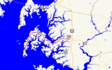
Maryland Route 33 is a state highway
in the U.S. state
of Maryland
. The state highway runs 23.17 mi (37.3 km) from Tilghman Island
east to Washington Street in Easton
. MD 33 connects Easton, the county seat
of Talbot County
, with all communities on the peninsula that juts west into the Chesapeake Bay
between the Miles River
and Eastern Bay
on the north and the Tred Avon River
and Choptank River
on the south. The state highway passes through the historic town of Saint Michaels, home of the Chesapeake Bay Maritime Museum
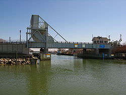
, and enters Tilghman Island by passing over Knapps Narrows on the busiest drawbridge
in the United States
.
MD 33 between Easton and Saint Michaels was one of the original state roads outlined by the Maryland State Roads Commission
in 1909. The state highway was constructed between Easton and Claiborne
, the terminus of a ferry
to Annapolis
, in the late 1910s and early 1920s, and was originally designated MD 17. The portion of the highway between Claiborne and Tilghman Island was constructed as MD 451 in the early 1930s. The state highway was extended north to MD 404
in Matapeake
on Kent Island
when the western terminus of the ferry from Claiborne was moved to Romancoke
in the late 1930s. MD 33 received its present number in a 1940 number swap with present MD 17
. Following the shutdown of the ferry, MD 33 was extended west along MD 451 to Tilghman Island and the Romancoke–Matapeake highway was redesignated MD 8
. In Easton, MD 33 was extended north along Washington Street in the late 1940s and then along Easton Parkway, presently MD 322
, in the mid 1960s, before the eastern terminus returned to its present location in the late 1970s.
that is the busiest drawbridge in the United States. Shortly after leaving Tilghman Island, the state highway passes through a mix of forest and farmland, passing the hamlets of Sherwood
and Wittman
and several pieces of old alignment of the highway. MD 33 curves to the east around the head of Harris Creek and passes through McDaniel
before reaching Claiborne Road, which was formerly MD 451 and heads northwest to the village of Claiborne.
 MD 33 continues southeast as St. Michaels Road. The state highway passes the northern terminus of MD 579
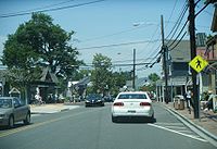
(Bozman Neavitt Road) and around the head of Broad Creek before curving south and passing through the town of Saint Michaels and its namesake historic district
. MD 33 is known as Talbot Street within the town, where the highway passes the entrance to the Chesapeake Bay Maritime Museum, marked by the previous drawbridge over Knapps Narrows. The state highway curves to the southeast within the town and continues straight out of town through a mix of farmland and forests until the hamlet of Newcomb
, where MD 329
(Royal Oak Road) splits to the south towards Royal Oak
and Bellevue
while MD 33 curves east to cross Oak Creek along the shore of the Miles River. MD 33 continues northeast, collecting the other end of MD 329 before passing a few riverfront subdivisions ahead of the intersection with MD 370
(Unionville Road). Shortly after entering the town limits of Easton, the state highway crosses Tanyard Branch at the intersection with MD 322 (Easton Parkway), a bypass of the town that connects with US 50
in both directions. MD 33 continues east as Bay Street toward downtown Easton, where the highway reaches its eastern terminus at Washington Street.
 The portion of present-day MD 33 between Easton and Saint Michaels was designated one of the original state roads when the Maryland State Roads Commission laid out the original state road system in 1909. However, the Easton–Saint Michaels road was not considered a necessary component of the system, so construction in its modern form was delayed in favor of the Easton–Wye Mills
road. A 2 miles (3.2 km) section of the road between the eastern intersection with MD 329 and MD 370 was paved by 1910. The first sections of modern MD 33 constructed by the State Roads Commission were between Saint Michaels and Claiborne, which became the terminus of the Claiborne–Annapolis Ferry in 1919. Sections were completed between the two villages in 1919 and 1920. A section of the highway was also completed between Easton and the MD 370 intersection in 1920. The Easton–Claiborne Road was completed in 1924. When numbers were assigned to certain state highways beginning in 1927, the road was designated MD 17.
The next section of present-day MD 33 was constructed between Claiborne and the highway's present western terminus on Tilghman Island as MD 451. The sections from Claiborne to a point between Wittman and Sherman and on Tilghman Island were completed around 1930. The gap between Knapps Narrows and Sherman was filled in 1933. MD 451 was completed when a new single bascule drawbridge was completed over Knapps Narrows in 1934. MD 17 was extended from Claiborne across Eastern Bay along Romancoke Road to MD 404 in Matapeake on Kent Island in 1938. This section was added in response to the replacement of the Claiborne–Annapolis ferry route with a Claiborne–Romancoke route in 1938, with traffic following the new section of MD 17 to Matapeake to take a second ferry across the Chesapeake Bay to Annapolis. MD 17 switched numbers with MD 33, the highway connecting Brunswick
and Wolfsville
in Frederick County
that is presently MD 17 in 1940.
 After a new, straighter US 213 (replaced by US 50 in 1949) was completed from south of Easton to Wye Mills in 1948, MD 33 was extended north along Washington Street within Easton to the new bypass. Following the closing of the Claiborne–Romancoke ferry in 1953, MD 33 and MD 451 switched alignments in 1957; MD 33 achieved its present western terminus at Tilghman Island while MD 451 became a short highway from MD 33 to Claiborne. MD 33 between Romancoke and Matapeake was redesignated MD 8 in 1960. MD 451 was removed from state maintenance in 1998.
Easton Parkway was constructed as a western bypass of Easton in the 1960s. MD 33 was moved from Washington Street to the part of the bypass north of present MD 33 when that section of Easton Parkway opened in 1965. MD 322, which was assigned to the southern part of Easton Parkway, replaced MD 33 on Bay Street between Easton Parkway and Washington Street, the latter of which became a northern extension of MD 565
. In 1978, MD 322 was assigned to all of Easton Parkway and MD 33 assumed its present eastern terminus. The Knapps Narrows drawbridge was replaced by a new drawbridge in 1998. The 1934 drawbridge was transferred to the entrance of the Chesapeake Bay Maritime Museum in Saint Michaels.
.
{| class=wikitable
|-
!Location
!Mile
!Destinations
!Notes
|-
|rowspan=2|Tilghman Island
|0.00
|Black Walnut Point Road south
|Western terminus
|-
|0.87
| colspan="2" style="text-align:center;"|Drawbridge over Knapps Narrows
|-
|rowspan=2|McDaniel
|10.00
|Claiborne Road north – Claiborne
|Former MD 451; old alignment of MD 33
|-
|10.81
|
|
|-
||St. Michaels
|13.10
|Dodson Avenue – Chesapeake Bay Maritime Museum
|
|-
|rowspan=2|Newcomb
|16.33
|
|
|-
|16.97
| colspan="2" style="text-align:center;"|Bridge over Oak Creek
|-
|rowspan=2|
|18.43
|
|
|-
|20.93
|
|
|-
|rowspan=2|Easton
|22.66
|
|
|-
|23.17
|Washington Street
|Eastern terminus; former MD 565 and US 213
State highway
State highway, state road or state route can refer to one of three related concepts, two of them related to a state or provincial government in a country that is divided into states or provinces :#A...
in the U.S. state
U.S. state
A U.S. state is any one of the 50 federated states of the United States of America that share sovereignty with the federal government. Because of this shared sovereignty, an American is a citizen both of the federal entity and of his or her state of domicile. Four states use the official title of...
of Maryland
Maryland
Maryland is a U.S. state located in the Mid Atlantic region of the United States, bordering Virginia, West Virginia, and the District of Columbia to its south and west; Pennsylvania to its north; and Delaware to its east...
. The state highway runs 23.17 mi (37.3 km) from Tilghman Island
Tilghman Island, Maryland
Tilghman Island is a census-designated place in Talbot County, Maryland, United States. The population was 854 at the 2000 census.- History :...
east to Washington Street in Easton
Easton, Maryland
Easton, founded 1710, is a town within the Easton District of Talbot County, Maryland, United States. The population was 11,708 at the 2000 census, and 14,677 according to current July 2008 census estimates. It is the county seat of Talbot County. The primary ZIP Code is 21601, and the...
. MD 33 connects Easton, the county seat
County seat
A county seat is an administrative center, or seat of government, for a county or civil parish. The term is primarily used in the United States....
of Talbot County
Talbot County, Maryland
-2010:Whereas according to the 2010 U.S. Census Bureau:*81.4% White*12.8% Black*0.2% Native American*1.2% Asian*0.1% Native Hawaiian or Pacific Islander*1.6% Two or more races*2.7% Other races*5.5% Hispanic or Latino -2000:...
, with all communities on the peninsula that juts west into the Chesapeake Bay
Chesapeake Bay
The Chesapeake Bay is the largest estuary in the United States. It lies off the Atlantic Ocean, surrounded by Maryland and Virginia. The Chesapeake Bay's drainage basin covers in the District of Columbia and parts of six states: New York, Pennsylvania, Delaware, Maryland, Virginia, and West...
between the Miles River
Miles River
The Miles River is a tidal river in Talbot County, Maryland. It is a tributary of the Eastern Bay and is thus part of the Chesapeake Bay watershed. The town of St. Michaels is located on the Miles River, and the river's name is believed to be derived from the name of the town.Its watershed area...
and Eastern Bay
Eastern Bay
The Eastern Bay is a tributary of the Chesapeake Bay located between Queen Anne's County, Maryland and Talbot County, Maryland on the Eastern Shore. Its main tributaries include the Miles River and the Wye River...
on the north and the Tred Avon River
Tred Avon River
The Tred Avon River is a main tributary of the Choptank River in Talbot County on Maryland's Eastern Shore. The river is long.-Geography:...
and Choptank River
Choptank River
The Choptank River is a major tributary of the Chesapeake Bay on the Delmarva Peninsula. Running for , it rises in Kent County, Delaware, runs through Caroline County, Maryland and forms much of the border between Talbot County, Maryland on the north, and Caroline County and Dorchester County on...
on the south. The state highway passes through the historic town of Saint Michaels, home of the Chesapeake Bay Maritime Museum
Chesapeake Bay Maritime Museum
The Chesapeake Bay Maritime Museum is located in St. Michaels, Maryland, United States and is home to a collection of Chesapeake Bay artifacts, exhibitions, and vessels. This interactive museum was founded in 1965 on Navy Point, once a site of seafood packing houses, docks, and work boats...
, and enters Tilghman Island by passing over Knapps Narrows on the busiest drawbridge
Drawbridge
A drawbridge is a type of movable bridge typically associated with the entrance of a castle surrounded by a moat. The term is often used to describe all different types of movable bridges, like bascule bridges and lift bridges.-Castle drawbridges:...
in the United States
United States
The United States of America is a federal constitutional republic comprising fifty states and a federal district...
.
MD 33 between Easton and Saint Michaels was one of the original state roads outlined by the Maryland State Roads Commission
Maryland State Highway Administration
The Maryland State Highway Administration is the state agency responsible for maintaining Maryland numbered highways outside of Baltimore City...
in 1909. The state highway was constructed between Easton and Claiborne
Claiborne, Maryland
Claiborne is an unincorporated community in Talbot County, Maryland. The village is located on the eastern shore of the Chesapeake Bay near the mouth of the Eastern Bay at , and uses ZIP code 21624. The 2000 U.S. Census lists the population as 147 and the number of homes as 84, slightly down from...
, the terminus of a ferry
Claiborne-Annapolis Ferry Company
The Claiborne-Annapolis Ferry Company ran both passenger and automobile ferry service across the Chesapeake Bay from 1919 to 1952. The initial service was between Annapolis, Maryland on the western shore and Claiborne, Maryland on the eastern shore. In July 1930, a second shorter route was added...
to Annapolis
Annapolis, Maryland
Annapolis is the capital of the U.S. state of Maryland, as well as the county seat of Anne Arundel County. It had a population of 38,394 at the 2010 census and is situated on the Chesapeake Bay at the mouth of the Severn River, south of Baltimore and about east of Washington, D.C. Annapolis is...
, in the late 1910s and early 1920s, and was originally designated MD 17. The portion of the highway between Claiborne and Tilghman Island was constructed as MD 451 in the early 1930s. The state highway was extended north to MD 404
Maryland Route 404
Maryland Route 404 is a major highway on Maryland's Eastern Shore in the United States. It runs from Maryland Route 662 in Wye Mills on the border of Queen Anne's and Talbot Counties, southeast to the Delaware state line in Caroline County, where the road continues as Delaware Route 404 to Nassau...
in Matapeake
Matapeake, Maryland
Matapeake is an unincorporated community located south of Stevensville on Kent Island, Maryland.It is named for the historic Matapeake Indian tribe, who lived there at the time of English colonization in 1631. Their chief village was on the southeast side of the island...
on Kent Island
Kent Island, Maryland
Kent Island is the largest island in the Chesapeake Bay, and a historic place in Maryland. To the east, a narrow channel known as the Kent Narrows barely separates the island from the Delmarva Peninsula, and on the other side, the island is separated from Sandy Point, an area near Annapolis, by...
when the western terminus of the ferry from Claiborne was moved to Romancoke
Romancoke, Maryland
Romancoke is an unincorporated community on Kent Island in Maryland, located at the southern end of Maryland Route 8. The United States Census Bureau defines an urban cluster for Romancoke, but not a census-designated place...
in the late 1930s. MD 33 received its present number in a 1940 number swap with present MD 17
Maryland Route 17
Maryland Route 17 is a state highway in the U.S. state of Maryland. The state highway begins at the Virginia state line at the Potomac River in Brunswick, where the highway continues south as Virginia State Route 287 . MD 17 runs north from the Brunswick Bridge to the Frederick–Washington...
. Following the shutdown of the ferry, MD 33 was extended west along MD 451 to Tilghman Island and the Romancoke–Matapeake highway was redesignated MD 8
Maryland Route 8
Maryland Route 8 is a state highway in the U.S. state of Maryland. Known for most of its length as Romancoke Road, the state highway runs from Romancoke Pier in Romancoke north to MD 18 in Stevensville. MD 8 is the main north–south highway of Kent Island in western Queen Anne's County. ...
. In Easton, MD 33 was extended north along Washington Street in the late 1940s and then along Easton Parkway, presently MD 322
Maryland Route 322
Maryland Route 322 is a state highway in the U.S. state of Maryland. Known as Easton Parkway, the highway runs on the west side of Easton between two junctions with U.S. Route 50...
, in the mid 1960s, before the eastern terminus returned to its present location in the late 1970s.
Route description
MD 33 begins at the start of state maintenance 0.1 mi (0.160934 km) south of Wharf Road and Phillips Road on Tilghman Island. The roadway continues south as Black Walnut Point Road, a county highway that leads to the namesake point at the south end of the island. MD 33 heads north through the village of Tilghman Island as two-lane Tilghman Island Road, passing Tilghman Elementary School and many businesses before leaving the island by crossing Knapps Narrows on a single bascule drawbridgeBascule bridge
A bascule bridge is a moveable bridge with a counterweight that continuously balances the span, or "leaf," throughout the entire upward swing in providing clearance for boat traffic....
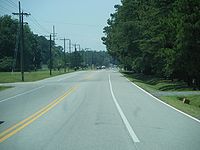
that is the busiest drawbridge in the United States. Shortly after leaving Tilghman Island, the state highway passes through a mix of forest and farmland, passing the hamlets of Sherwood
Sherwood, Maryland
Sherwood is an unincorporated community in Talbot County, Maryland, United States. The United States Postal Service has assigned Sherwood the ZIP Code 21665.In 2002 HGTV built their dream home here....
and Wittman
Wittman, Maryland
Wittman is an unincorporated community in Talbot County, Maryland, United States. Although it is unincorporated, it has a post office, with the ZIP code of 21676.-References:...
and several pieces of old alignment of the highway. MD 33 curves to the east around the head of Harris Creek and passes through McDaniel
McDaniel, Maryland
McDaniel is an unincorporated community in Talbot County, Maryland, United States.-References:...
before reaching Claiborne Road, which was formerly MD 451 and heads northwest to the village of Claiborne.
Maryland Route 579
Maryland Route 579 is a state highway in the U.S. state of Maryland. Known as Bozman Neavitt Road, the state highway runs from the beginning of state maintenance in Neavitt north to MD 33 near St. Michaels. MD 579 provides access to the peninsula containing Neavitt and Bozman, which lies...
(Bozman Neavitt Road) and around the head of Broad Creek before curving south and passing through the town of Saint Michaels and its namesake historic district
St. Michaels Historic District
The Saint Michaels Historic District encompasses the historic center of Saint Michaels, Maryland, U.S.A. The late 18th and early 19th century town is a small seaport on a tributary of the Chesapeake Bay which has retained a high degree of historic integrity. Of particular interest are an unusual...
. MD 33 is known as Talbot Street within the town, where the highway passes the entrance to the Chesapeake Bay Maritime Museum, marked by the previous drawbridge over Knapps Narrows. The state highway curves to the southeast within the town and continues straight out of town through a mix of farmland and forests until the hamlet of Newcomb
Newcomb, Maryland
Newcomb is an unincorporated community in Talbot County, Maryland, United States.-References:...
, where MD 329
Maryland Route 329
Maryland Route 329 is a state highway in the U.S. state of Maryland. Known as Royal Oak Road, the state highway runs through Royal Oak in western Talbot County, connecting with MD 33 at both termini...
(Royal Oak Road) splits to the south towards Royal Oak
Royal Oak, Maryland
Royal Oak is an unincorporated community in Talbot County, Maryland, United States.-References:...
and Bellevue
Bellevue, Maryland
Bellevue is an unincorporated community in Talbot County, Maryland, United States.Bellevue lies on the north bank of the Tred Avon River, and is linked to Oxford by a vehicle ferry across the river.-References:...
while MD 33 curves east to cross Oak Creek along the shore of the Miles River. MD 33 continues northeast, collecting the other end of MD 329 before passing a few riverfront subdivisions ahead of the intersection with MD 370
Maryland Route 370
Maryland Route 370 is a state highway in the U.S. state of Maryland. Known as Unionville Road, the state highway runs from MD 33 near Easton to Miles River Road near Unionville. MD 370 connects Easton with the northwestern Talbot County villages of Unionville and Tunis Mills, which are...
(Unionville Road). Shortly after entering the town limits of Easton, the state highway crosses Tanyard Branch at the intersection with MD 322 (Easton Parkway), a bypass of the town that connects with US 50
U.S. Route 50 in Maryland
U.S. Route 50 is a major east–west route of the U.S. Highway system, stretching just over from Ocean City, Maryland on the Atlantic Ocean to West Sacramento, California. In the U.S. state of Maryland, US 50 exists in two sections. The longer of these serves as a major route connecting...
in both directions. MD 33 continues east as Bay Street toward downtown Easton, where the highway reaches its eastern terminus at Washington Street.
History
Wye Mills, Maryland
Wye Mills is an unincorporated community in Talbot County, Maryland, United States, located at an altitude of 13 feet . It is the home of the Wye Grist Mill which has been in nearly continuous operation since 1682, and Wye Oak and of Chesapeake College.-References:...
road. A 2 miles (3.2 km) section of the road between the eastern intersection with MD 329 and MD 370 was paved by 1910. The first sections of modern MD 33 constructed by the State Roads Commission were between Saint Michaels and Claiborne, which became the terminus of the Claiborne–Annapolis Ferry in 1919. Sections were completed between the two villages in 1919 and 1920. A section of the highway was also completed between Easton and the MD 370 intersection in 1920. The Easton–Claiborne Road was completed in 1924. When numbers were assigned to certain state highways beginning in 1927, the road was designated MD 17.
The next section of present-day MD 33 was constructed between Claiborne and the highway's present western terminus on Tilghman Island as MD 451. The sections from Claiborne to a point between Wittman and Sherman and on Tilghman Island were completed around 1930. The gap between Knapps Narrows and Sherman was filled in 1933. MD 451 was completed when a new single bascule drawbridge was completed over Knapps Narrows in 1934. MD 17 was extended from Claiborne across Eastern Bay along Romancoke Road to MD 404 in Matapeake on Kent Island in 1938. This section was added in response to the replacement of the Claiborne–Annapolis ferry route with a Claiborne–Romancoke route in 1938, with traffic following the new section of MD 17 to Matapeake to take a second ferry across the Chesapeake Bay to Annapolis. MD 17 switched numbers with MD 33, the highway connecting Brunswick
Brunswick, Maryland
Brunswick is a city in Frederick County, Maryland, United States. The population was 5,870 at the 2010 census.- History :The area now known as Brunswick was originally home to the Susquehanna Indians. In 1728 the first settlement was built, and the region became known as Eel Town, because the...
and Wolfsville
Wolfsville, Maryland
Wolfsville is an unincorporated community in Frederick County, Maryland, United States.-References:...
in Frederick County
Frederick County, Maryland
Frederick County is a county located in the western part of the U.S. state of Maryland, bordering the southern border of Pennsylvania and the northeastern border of Virginia. As of the 2010 Census, the population was 233,385....
that is presently MD 17 in 1940.
Easton Parkway was constructed as a western bypass of Easton in the 1960s. MD 33 was moved from Washington Street to the part of the bypass north of present MD 33 when that section of Easton Parkway opened in 1965. MD 322, which was assigned to the southern part of Easton Parkway, replaced MD 33 on Bay Street between Easton Parkway and Washington Street, the latter of which became a northern extension of MD 565
Maryland Route 565
Maryland Route 565 is a collection of state highways in the U.S. state of Maryland. These three highways are sections of old alignment of U.S. Route 213, the predecessor route to US 50, between Trappe and Easton. MD 565 runs from Trappe to US 50 south of Easton. MD 565A is a section of...
. In 1978, MD 322 was assigned to all of Easton Parkway and MD 33 assumed its present eastern terminus. The Knapps Narrows drawbridge was replaced by a new drawbridge in 1998. The 1934 drawbridge was transferred to the entrance of the Chesapeake Bay Maritime Museum in Saint Michaels.
Junction list
The entire route is in Talbot CountyTalbot County, Maryland
-2010:Whereas according to the 2010 U.S. Census Bureau:*81.4% White*12.8% Black*0.2% Native American*1.2% Asian*0.1% Native Hawaiian or Pacific Islander*1.6% Two or more races*2.7% Other races*5.5% Hispanic or Latino -2000:...
.
{| class=wikitable
|-
!Location
!Mile
!Destinations
!Notes
|-
|rowspan=2|Tilghman Island
Tilghman Island, Maryland
Tilghman Island is a census-designated place in Talbot County, Maryland, United States. The population was 854 at the 2000 census.- History :...
|0.00
|Black Walnut Point Road south
|Western terminus
|-
|0.87
| colspan="2" style="text-align:center;"|Drawbridge over Knapps Narrows
|-
|rowspan=2|McDaniel
McDaniel, Maryland
McDaniel is an unincorporated community in Talbot County, Maryland, United States.-References:...
|10.00
|Claiborne Road north – Claiborne
Claiborne, Maryland
Claiborne is an unincorporated community in Talbot County, Maryland. The village is located on the eastern shore of the Chesapeake Bay near the mouth of the Eastern Bay at , and uses ZIP code 21624. The 2000 U.S. Census lists the population as 147 and the number of homes as 84, slightly down from...
|Former MD 451; old alignment of MD 33
|-
|10.81
|
|
|-
||St. Michaels
St. Michaels, Maryland
Saint Michaels is a town in Talbot County, Maryland, United States. The population was 1,193 at the 2000 census. Saint Michaels derives its name from the Episcopal Parish established here in 1677...
|13.10
|Dodson Avenue – Chesapeake Bay Maritime Museum
Chesapeake Bay Maritime Museum
The Chesapeake Bay Maritime Museum is located in St. Michaels, Maryland, United States and is home to a collection of Chesapeake Bay artifacts, exhibitions, and vessels. This interactive museum was founded in 1965 on Navy Point, once a site of seafood packing houses, docks, and work boats...
|
|-
|rowspan=2|Newcomb
Newcomb, Maryland
Newcomb is an unincorporated community in Talbot County, Maryland, United States.-References:...
|16.33
|
|
|-
|16.97
| colspan="2" style="text-align:center;"|Bridge over Oak Creek
|-
|rowspan=2|
|18.43
|
|
|-
|20.93
|
|
|-
|rowspan=2|Easton
Easton, Maryland
Easton, founded 1710, is a town within the Easton District of Talbot County, Maryland, United States. The population was 11,708 at the 2000 census, and 14,677 according to current July 2008 census estimates. It is the county seat of Talbot County. The primary ZIP Code is 21601, and the...
|22.66
|
|
|-
|23.17
|Washington Street
|Eastern terminus; former MD 565 and US 213