
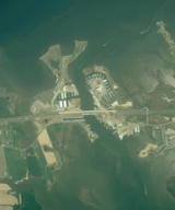
Kent Narrows
Encyclopedia

Chester River
The Chester River is a major tributary of the Chesapeake Bay on the Delmarva Peninsula. It is about long, and its watershed encompasses , which includes of land. Thus the total watershed area is 20% water. It forms the border between Kent County and Queen Anne's County, Maryland, with its...
with the Eastern Bay
Eastern Bay
The Eastern Bay is a tributary of the Chesapeake Bay located between Queen Anne's County, Maryland and Talbot County, Maryland on the Eastern Shore. Its main tributaries include the Miles River and the Wye River...
and also separates Kent Island
Kent Island, Maryland
Kent Island is the largest island in the Chesapeake Bay, and a historic place in Maryland. To the east, a narrow channel known as the Kent Narrows barely separates the island from the Delmarva Peninsula, and on the other side, the island is separated from Sandy Point, an area near Annapolis, by...
from the Delmarva Peninsula
Delmarva Peninsula
The Delmarva Peninsula is a large peninsula on the East Coast of the United States, occupied by most of Delaware and portions of Maryland and Virginia...
. It runs through the community of Kent Narrows, Maryland
Kent Narrows, Maryland
Kent Narrows is a census-designated place and town in Queen Anne's County, Maryland, United States. As of the 2000 census, the town had a population of 567.-Geography:Kent Narrows is located at ....
. The Kent Narrows was originally shallow and surrounded by marsh
Marsh
In geography, a marsh, or morass, is a type of wetland that is subject to frequent or continuous flood. Typically the water is shallow and features grasses, rushes, reeds, typhas, sedges, other herbaceous plants, and moss....
. A causeway was built across it in 1826, but was removed in 1876 when the channel was dredged. Today the Kent Narrows continues to be dredged regularly. The area has traditionally been a location for seafood
Seafood
Seafood is any form of marine life regarded as food by humans. Seafoods include fish, molluscs , crustaceans , echinoderms . Edible sea plants, such as some seaweeds and microalgae, are also seafood, and are widely eaten around the world, especially in Asia...
packing and restaurants.
Bridges
Several bridges, both part of roads and the Queen Anne's RailroadQueen Anne's Railroad
The Queen Anne’s Railroad was a railroad that ran from Love Point, Maryland to Lewes, Delaware and was connected to Baltimore via ferry. The Queen Anne's Railroad company was formed in Maryland in 1894, and received legislative authorization from Delaware in February 1895...
, have crossed the Kent Narrows in the past. Currently, two road bridges cross the Kent Narrows.
- The Kent Narrows Bridge is part of US 50U.S. Route 50U.S. Route 50 is a major east–west route of the U.S. Highway system, stretching just over from Ocean City, Maryland on the Atlantic Ocean to West Sacramento, California. Until 1972, when it was replaced by Interstate Highways west of the Sacramento area, it extended to San Francisco, near...
/US 301U.S. Route 301U.S. Route 301 is a spur of U.S. Route 1 running through the South Atlantic States. It currently runs 1,099 miles from Glasgow, Delaware at U.S. Route 40 to Sarasota, Florida. It passes through the states of Delaware, Maryland, Virginia, North Carolina, South Carolina, Georgia, and Florida...
and was built during the early 1990s as part of upgrades to US 50/US 301 on the Eastern Shore of Maryland. - The Waterman's Memorial Bridge formally known as, The Old Kent Narrows Bridge DrawbridgeBascule bridgeA bascule bridge is a moveable bridge with a counterweight that continuously balances the span, or "leaf," throughout the entire upward swing in providing clearance for boat traffic....
, is part of Maryland Route 18Maryland Route 18Maryland Route 18 is a state highway in the U.S. state of Maryland. The state highway runs from the beginning of state maintenance at Love Point east to MD 213 in Centreville...
as well as the American Discovery TrailAmerican Discovery TrailThe American Discovery Trail is a coast-to-coast hiking and biking trail across the mid-tier of the United States. It starts on the Delmarva Peninsula on the Atlantic Ocean and ends on the northern California coast on the Pacific Ocean, and is signed on over of trail. This includes the doubled...
and serves local traffic, both automobiles and pedestrians. It once carried US 50 as the main bridge across the Kent Narrows until the newer bridge was built.