
Maryland Route 313
Encyclopedia
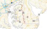
Maryland Route 313 is a state highway
located on the Eastern Shore of Maryland
in the United States. The 75.72 miles (121.86 km) route runs from U.S. Route 50
in Mardela Springs
, Wicomico County
north to Maryland Route 213
and Maryland Route 290
in Galena
, Kent County
. It is predominantly a rural two-lane road that runs through agricultural areas a short distance west of the Delaware
border, with the exception of a four-lane divided
bypass of Denton
shared with Maryland Route 404
. MD 313 serves many communities, including Sharptown
, Eldorado
, Federalsburg
, Denton, Greensboro
, Goldsboro
, Barclay
, Sudlersville
, Millington
, and Massey
. The route intersects many major roads, including Maryland Route 54 in Mardela Springs, Maryland Route 404 in the Denton area, Maryland Route 302
in Barclay, Maryland Route 300
in Sudlersville, and U.S. Route 301
near Massey.
The designation MD 313 was first used prior to 1927 for the road running from Eldorado to Galena, while the portion south to Mardela Springs was designated a part of U.S. Route 213. By 1940, the route was extended to Mardela Springs following a realignment of US 213. A few realignments to MD 313 had occurred by 1960 including one that moved the route to a new road between Federalsburg and Denton. In the 1980s, a four-lane divided bypass of Denton was built and the former alignment of MD 313 in the town became Maryland Route 619
. This divided highway was extended further south of Denton in the early 2000s. The remaining two-lane portions of MD 313 that are concurrent with MD 404 are slated to be upgraded to a four-lane divided highway to provide relief to beach traffic along MD 404, a part of the main route between the Chesapeake Bay Bridge
and the Delaware beaches.
, generally a short distance west of the Delaware
border. The route heads through five counties in Maryland from south to north: Wicomico
, Dorchester
, Caroline
, Queen Anne's
, and Kent
. It connects several towns including Mardela Springs
and Sharptown
in Wicomico County, Eldorado
in Dorchester County, Federalsburg
, Denton
, Greensboro
and Goldsboro
in Caroline County, Barclay
and Sudlersville
in Queen Anne's County, and Millington
and Galena
in Kent County.
 Maryland Route 313 begins at an intersection with U.S. Route 50
in Mardela Springs
, Wicomico County
, where the route heads east past residences along Delmar Road, a 30 mph (48.3 km/h) two-lane undivided road. A short distance past US 50, the route turns north onto Sharptown Road, with Maryland Route 54 continuing east on Delmar Road toward the Delaware
-Maryland state border town of Delmar
. The route continues north past more residences, with the speed limit increasing to 40 mph (64.4 km/h) and then to 50 mph (80.5 km/h) as it leaves Mardela Springs and heads into farmland a short distance west of the Delaware border. It continues through a mix of woods and farms with some residences before reaching Sharptown
. Here, the road intersects Maryland Route 813F (Twiford Road). MD 313 bypasses Sharptown to the south and intersects Maryland Route 348
(Laurel Road). Past this intersection, the route turns north and runs along the eastern edge of the town before crossing over the Nanticoke River
.
In Wicomico County, the daily traffic counts on MD 313 range from a high of 4,882 vehicles at the intersection with US 50 in Mardela Springs to a low of 1,552 vehicles at the intersection with MD 54 in Mardela Springs in 2007.
and heads northwest through wooded areas before continuing into a mix of woodland and farmland. It turns west before heading northwest again and reaching the town of Eldorado
. Here, the speed limit drops to 30 mph (48.3 km/h) and the route intersects the eastern terminus of Maryland Route 14
(Rhodesdale Eldorado Road). At this intersection, MD 313 makes a right turn to head north on Eldorado Road. The route leaves Eldorado and the speed limit increases to 50 mph (80.5 km/h) again as it continues through farmland with some patches of woods. It intersects Maryland Route 392
(Finchville Reliance Road) in Finchville and passes more farming areas with intermittent residences before coming to an intersection with Maryland Route 577
(Reliance Road) on the Caroline County
border in Allens Corner.
In Dorchester County, the daily traffic counts on MD 313 range from a high of 2,261 vehicles at the intersection with Wheatley Church Road to a low of 1,461 vehicles at the intersection with Dog Kennel Road in 2007.
, passing through a mix of agricultural and residential areas. The route then leaves the border line and enters Caroline County, intersecting Maryland Route 318
(Federalsburg Highway) and making a left turn to form a concurrency
with that route. The two routes bypass Federalsburg to the south as a 50 mph (80.5 km/h) road, crossing over Marshyhope Creek
. After crossing the creek, the road intersects Maryland Route 308 (South Main Street). The road passes an industrial park before turning north into wooded areas and crossing a Maryland & Delaware Railroad line. After the railroad crossing, MD 313 and MD 318 intersect Maryland Route 307
(Williamsburg Road) at a roundabout
located in the southwestern corner of Federalsburg. A short distance later, MD 318 splits from MD 313 by heading west on Preston Road while Maryland Route 315
continues east into Federalsburg on Bloomingdale Avenue. Past this intersection, MD 313 continues north on the Federalsburg Highway, leaving the Federalsburg area and heading into a mix of woodland and farmland.
 In Andersontown
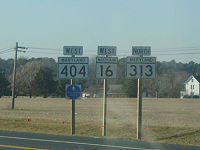
, MD 313 intersects Maryland Route 16
and Maryland Route 404
(Shore Highway), which constitutes a part of the main route between the Chesapeake Bay Bridge
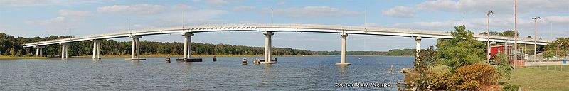
and the Delaware beaches. Here, the route makes a left turn onto that road, forming a three-route concurrency. At this point, the Shore Highway has a speed limit of 55 mph (88.5 km/h) and heads northwest through a mix of woods and farms with some homes before widening to a four-lane divided highway
. Upon widening into a divided highway, MD 16 splits from MD 313 and MD 404 at an intersection and heads west on Harmony Road. Past this intersection, MD 313 crosses over Watts Creek and heads north through farmland, passing Martinak State Park
. The speed limit decreases to 40 mph (64.4 km/h) as the road heads into commercial areas in the southern part of Denton
. The road turns northeast into woods and intersects the eastern terminus of Maryland Route 404 Business (Franklin Street/Gay Street) at an at-grade intersection. Past this intersection, MD 313 and MD 404 become a 55 mph (88.5 km/h) limited-access road and head north, passing residential neighborhoods and woodland along the eastern side of Denton. The road turns to the west and comes to a diamond interchange
. Here MD 313 splits from MD 404 by heading north on two-lane undivided Greensboro Road and Maryland Route 619
, while the former routing of MD 313 in Denton heads south into Denton on Sixth Street.
The route heads through farmland before passing residences as a 40 mph (64.4 km/h) road and intersecting the western terminus of Maryland Route 317
(Burrsville Road) in Oil City
. Past MD 317, the speed limit increases to 50 mph (80.5 km/h) and the road continues through mostly wooded areas with some residences and farmland. It reaches the town of Greensboro
, where the speed limit drops to 30 mph (48.3 km/h) and MD 313 intersects Maryland Route 314
(Whiteleysburg Road). The route crosses the Choptank River
past MD 314, with the speed limit increasing to 40 mph (64.4 km/h) and then to 50 mph (80.5 km/h) before the intersection with the eastern terminus of Maryland Route 480
(Ridgely Road) just north of Greensboro. The road continues north through agricultural areas before entering Goldsboro
, where the speed limit decreases to 30 mph (48.3 km/h) and it becomes Old Town Road. In Goldsboro, MD 313 intersects Maryland Route 311
(Main Street) and continues through residential areas before coming to an intersection with Maryland Route 287
(Old Line Road). Here, the route makes a left turn to head west on Goldsboro Road. MD 313 leaves Goldsboro and becomes a 50 mph (80.5 km/h) road that heads into a mix of farmland and woodland. The road intersects unsigned Maryland Route 820 (Castle Hall Road). Past this intersection, MD 313 turns to the northwest and intersects the northern terminus of Maryland Route 312
(Oakland Road) in Baltimore Corner
, where it heads north through farm fields past that intersection.
In Caroline County, the daily traffic counts on MD 313 range from a high of 15,952 vehicles at the intersection with MD 404 Business along the MD 404 concurrency in Denton to a low of 1,861 vehicles at the intersection with Red Bridges Road between Greensboro and Goldsboro in 2007.
and continues north through more farmland, before intersecting the eastern terminus of Maryland Route 19
(Roberts Station Road) in Ingleside
. The route proceeds north, with a traffic count of 2,270 vehicles at the Merrick Corner Road intersection, before reaching the town of Barclay
. Here, the road passes residences with a speed limit of 30 mph (48.3 km/h) and intersects Maryland Route 302
(Church Street). Past this intersection, the road crosses a Maryland & Delaware Railroad line before leaving Barclay and heading back into agricultural areas as a 50 mph (80.5 km/h) road. The Maryland & Delaware Railroad line runs a short distance to the east of MD 313 before eventually running next to the road as it passes through a mix of farms, woods, and residences. The route enters Sudlersville
, where the speed limit decreases to 25 mph (40.2 km/h) and it passes through residential areas in the town on Church Street, with the railroad line drawing farther to the east. In the center of town, the road intersects Maryland Route 300
(Main Street). Past the MD 300 intersection, MD 313 intersects Maryland Route 837 (Church Circle), an unsigned loop to westbound MD 300. Upon leaving Sudlersville, the route becomes 50 mph (80.5 km/h) Millington Road and heads north through farm fields with intermittent residences. MD 313 heads into forested areas as it runs a short distance to the east of U.S. Route 301
. It leaves the woodland as it intersects the eastern terminus of Maryland Route 544
(Mcginnis Road). The route heads northeast through a mix of agricultural and residential areas before turning east in a patch of woodland and passing more farm fields and residences. MD 313 turns northeast into wooded residential areas and enters Millington
, where it becomes 25 mph (40.2 km/h) Sassafras Street.
In Queen Anne's County, the daily traffic counts on MD 313 range from a high of 2,880 vehicles at the intersection with MD 544 south of Millington to a low of 1,880 vehicles at the intersection with MD 19 in Ingleside in 2007.
 MD 313 crosses the Chester River
into Kent County
, where it continues north through Millington and crosses Maryland Route 291
(Cypress Street). The road passes more residences before leaving Millington and becoming Millington Massey Road, a 50 mph (80.5 km/h) road that passes by farmland and some residences. MD 313 reaches Massey
, where it passes by residences as a 25 mph (40.2 km/h) road before coming to an intersection at the center of town where it makes a left turn onto Massey Galena Road. It is here that Maryland Route 299
heads north on Massey Road and Maryland Route 330
heads east on Massey Delaware Line Road. The route leaves Massey and heads west through farm fields as a 50 mph (80.5 km/h) road, crossing another Maryland & Delaware Railroad line before heading northwest into forested areas. The route intersects the multi-lane, divided U.S. Route 301 (Blue Star Memorial Highway) at a superstreet
intersection in which traffic on MD 313 cannot continue directly across US 301 and must use a reversing loop
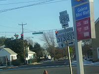
in the median of that route. Past the US 301 intersection, the route officially becomes Maryland Route 313A, but is still signed as Maryland Route 313. It heads west through farmland before turning north and intersecting Maryland Route 290
(Chesterville Road). The two routes continue north together into Galena
, where the speed limit drops to 25 mph (40.2 km/h) and the road becomes Main Street. It passes residences before intersecting Maryland Route 213
(Main Street) in the center of town where MD 313 ends, MD 290 turns east on Cross Street, and MD 213 goes northbound on Main Street and southbound by going west on Cross Street.
In Kent County, the daily traffic counts on MD 313 range from a high of 3,992 vehicles at the intersection with MD 290 south of Galena to a low of 1,742 vehicles at the intersection with MD 291 in Millington in 2007.
to Elkton
. By 1940, US 213 was realigned to follow present-day US 50 between Mardela Springs and Easton
, and MD 313 was extended south to end at US 213 in Mardela Springs. By 1960, a few realignments of MD 313 had taken place. The route was moved to its current alignment between Federalsburg and Denton after originally following American Corner Road and MD 16 between the two towns. In addition, the route was rerouted to bypass Greensboro instead of passing through the town on Sunset Avenue (present-day MD 314) and Main Street (present-day MD 480) and a bypass of MD 313 was built east of Ingleside in place of following Roberts Station Road (present-day MD 19) and St. Paul Road. In the early 1980s, a four-lane divided bypass of Denton was constructed for MD 313 and MD 404, with the alignment of MD 313 through Denton became MD 619. A superstreet intersection was built at US 301 in 2000, resulting in the northern terminus of MD 313 being officially moved to US 301 and the portion of the route between US 301 and MD 213 being designated MD 313A.Despite this, MD 313A is still signed as MD 313. The divided highway portion of the route in the Denton area was extended further in the 2000s from the south end of Denton to the Sennett Road intersection south of where MD 16 joins the route. This project received $3 million from the federal government in 2001. The remaining two-lane portions of MD 313 that are concurrent with MD 404 are slated to be widened into a four-lane divided highway in order to provide relief to travelers driving to the ocean resorts along MD 404.
State highway
State highway, state road or state route can refer to one of three related concepts, two of them related to a state or provincial government in a country that is divided into states or provinces :#A...
located on the Eastern Shore of Maryland
Maryland
Maryland is a U.S. state located in the Mid Atlantic region of the United States, bordering Virginia, West Virginia, and the District of Columbia to its south and west; Pennsylvania to its north; and Delaware to its east...
in the United States. The 75.72 miles (121.86 km) route runs from U.S. Route 50
U.S. Route 50 in Maryland
U.S. Route 50 is a major east–west route of the U.S. Highway system, stretching just over from Ocean City, Maryland on the Atlantic Ocean to West Sacramento, California. In the U.S. state of Maryland, US 50 exists in two sections. The longer of these serves as a major route connecting...
in Mardela Springs
Mardela Springs, Maryland
Mardela Springs is a town in Wicomico County, Maryland, United States. The population was 364 at the 2000 census. It is included in the Salisbury, Maryland Metropolitan Statistical Area.-Geography:Mardela Springs is located at ....
, Wicomico County
Wicomico County, Maryland
As of the census of 2010, there were 98,733 people, 37,220 households, and 24,172 families residing in the county. The population density was 261.7 people per square mile . There were 41,192 housing units at an average density of 109.2 per square mile...
north to Maryland Route 213
Maryland Route 213
Maryland Route 213 is a state highway located on the Eastern Shore of Maryland in the United States. The route runs from Maryland Route 662 in Wye Mills, Queen Anne's County north to the Pennsylvania border in Cecil County, where it continues into that state as Pennsylvania Route 841...
and Maryland Route 290
Maryland Route 290
Maryland Route 290 is a state highway in the U.S. state of Maryland. The state highway runs from MD 300 at Dudley Corners north to MD 299 in Sassafras. MD 290 roughly parallels U.S. Route 301 , which it intersects twice, as it connects the communities of Crumpton in northern Queen Anne's County...
in Galena
Galena, Maryland
Galena is a town in Kent County, Maryland, United States. The population was 428 at the 2000 census.-Geography:Galena is located at .According to the United States Census Bureau, the town has a total area of , all of it land....
, Kent County
Kent County, Maryland
Kent County is a county located in the U.S. state of Maryland, on its Eastern Shore. It was named for the county of Kent in England. Its county seat is Chestertown. In 2010, the county population was 20,197...
. It is predominantly a rural two-lane road that runs through agricultural areas a short distance west of the Delaware
Delaware
Delaware is a U.S. state located on the Atlantic Coast in the Mid-Atlantic region of the United States. It is bordered to the south and west by Maryland, and to the north by Pennsylvania...
border, with the exception of a four-lane divided
Divided Highway
Divided Highway is a compilation album by American rock band The Doobie Brothers, released in 2003. . All tracks are taken from the albums Cycles and Brotherhood .-Track listing:...
bypass of Denton
Denton, Maryland
Denton is a town in Caroline County, Maryland, United States. The population was 2,960 at the 2000 census. It is the county seat of Caroline County. Denton is the birthplace of former Delaware governor Sherman W. Tribbitt and author Sophie Kerr, as well as the long time home of former Maryland...
shared with Maryland Route 404
Maryland Route 404
Maryland Route 404 is a major highway on Maryland's Eastern Shore in the United States. It runs from Maryland Route 662 in Wye Mills on the border of Queen Anne's and Talbot Counties, southeast to the Delaware state line in Caroline County, where the road continues as Delaware Route 404 to Nassau...
. MD 313 serves many communities, including Sharptown
Sharptown, Maryland
Sharptown is a town in Wicomico County, Maryland, United States. The population was 649 at the 2000 census. It is included in the Salisbury, Maryland Metropolitan Statistical Area.-Geography:Sharptown is located at ....
, Eldorado
Eldorado, Maryland
Eldorado is a town in Dorchester County, Maryland, United States. The population was 60 at the 2000 census.-History:Rehoboth was listed on the National Register of Historic Places in 1972...
, Federalsburg
Federalsburg, Maryland
Federalsburg is a town in Caroline County, Maryland, United States. The population was 2,642 at the 2009 census. The ZIP code is 21632. The primary phone exchange is 754 and the area code is 410.-Town features:...
, Denton, Greensboro
Greensboro, Maryland
Greensboro is a town located on the banks of the Choptank River in Caroline County, Maryland. The population was 1,632 at the 2000 census. The ZIP code is 21639. The primary phone exchange is 482 and the area code is 410...
, Goldsboro
Goldsboro, Maryland
Goldsboro is a town in Caroline County, Maryland, United States. The population was 216 at the 2000 census. The zipcode is 21636. It is named after Thomas Alan Goldsborough...
, Barclay
Barclay, Maryland
Barclay is a town in Queen Anne's County, Maryland, in the United States. As of the 2000 census, the town population was 143.-Geography:Barclay is located at ....
, Sudlersville
Sudlersville, Maryland
Sudlersville is a town in Queen Anne's County, Maryland. The ZIP code is 21668 and the area code is 410. The population was 391 at the 2000 census...
, Millington
Millington, Maryland
Millington is a town in Kent and Queen Anne's counties in the U.S. state of Maryland. The population was 416 at the 2000 census.-Geography:Millington is located at ....
, and Massey
Massey, Maryland
Massey is an unincorporated community in Kent County, Maryland, United States.-References:...
. The route intersects many major roads, including Maryland Route 54 in Mardela Springs, Maryland Route 404 in the Denton area, Maryland Route 302
Maryland Route 302
Maryland Route 302 is a state highway in the U.S. state of Maryland. Known for most of its length as Barclay Road, the state highway runs from U.S. Route 301 west of Barclay east to the Delaware state line east of Templeville, where the highway continues east as Delaware Route 11...
in Barclay, Maryland Route 300
Maryland Route 300
Maryland Route 300 is a state highway in the U.S. state of Maryland. Known for most of its length as Sudlersville Road, the state highway runs from MD 213 in Church Hill east to the Delaware state line, where the highway continues as Delaware Route 300...
in Sudlersville, and U.S. Route 301
U.S. Route 301 in Maryland
U.S. Route 301 in Maryland is a major highway that runs from Delaware to the Governor Harry W. Nice Memorial Bridge into Virginia. It passes through three of Maryland's four main regions: the Eastern Shore, the Baltimore-Washington Metropolitan Area, and Southern Maryland...
near Massey.
The designation MD 313 was first used prior to 1927 for the road running from Eldorado to Galena, while the portion south to Mardela Springs was designated a part of U.S. Route 213. By 1940, the route was extended to Mardela Springs following a realignment of US 213. A few realignments to MD 313 had occurred by 1960 including one that moved the route to a new road between Federalsburg and Denton. In the 1980s, a four-lane divided bypass of Denton was built and the former alignment of MD 313 in the town became Maryland Route 619
Maryland Route 619
-External links:*...
. This divided highway was extended further south of Denton in the early 2000s. The remaining two-lane portions of MD 313 that are concurrent with MD 404 are slated to be upgraded to a four-lane divided highway to provide relief to beach traffic along MD 404, a part of the main route between the Chesapeake Bay Bridge
Chesapeake Bay Bridge
The Chesapeake Bay Bridge is a major dual-span bridge in the U.S. state of Maryland. Spanning the Chesapeake Bay, it connects the state's rural Eastern Shore region with the more urban Western Shore. The original span opened in 1952 and, at the time, with a length of , it was the world's longest...
and the Delaware beaches.
Route description
MD 313 runs through rural areas of woods and farms on the Eastern Shore of MarylandEastern Shore of Maryland
The Eastern Shore of Maryland is a territorial part of the U.S. state of Maryland that lies predominately on the east side of the Chesapeake Bay and consists of nine counties. The origin of term Eastern Shore was derived to distinguish a territorial part of the State of Maryland from the Western...
, generally a short distance west of the Delaware
Delaware
Delaware is a U.S. state located on the Atlantic Coast in the Mid-Atlantic region of the United States. It is bordered to the south and west by Maryland, and to the north by Pennsylvania...
border. The route heads through five counties in Maryland from south to north: Wicomico
Wicomico County, Maryland
As of the census of 2010, there were 98,733 people, 37,220 households, and 24,172 families residing in the county. The population density was 261.7 people per square mile . There were 41,192 housing units at an average density of 109.2 per square mile...
, Dorchester
Dorchester County, Maryland
Dorchester County is a county located in the U.S. state of Maryland on its Eastern Shore. It is bordered by the Choptank River to the north, Talbot County to the northwest, Caroline County to the northeast, Wicomico County to the southeast, Sussex County, Delaware, to the east, and the Chesapeake...
, Caroline
Caroline County, Maryland
Caroline County is a wholly rural county located in the U.S. state of Maryland on its Eastern Shore. It is bordered by Queen Anne's County to the north, Talbot County to the west, Dorchester County to the south, Kent County, Delaware, to the east, and Sussex County, Delaware, to the southeast. As...
, Queen Anne's
Queen Anne's County, Maryland
Queen Anne's County is a county located on the Eastern Shore of the U.S. state of Maryland.As of 2010, the population was 47,798. Its county seat and most populous municipality is Centreville. The census-designated place of Stevensville is the county's most populous place...
, and Kent
Kent County, Maryland
Kent County is a county located in the U.S. state of Maryland, on its Eastern Shore. It was named for the county of Kent in England. Its county seat is Chestertown. In 2010, the county population was 20,197...
. It connects several towns including Mardela Springs
Mardela Springs, Maryland
Mardela Springs is a town in Wicomico County, Maryland, United States. The population was 364 at the 2000 census. It is included in the Salisbury, Maryland Metropolitan Statistical Area.-Geography:Mardela Springs is located at ....
and Sharptown
Sharptown, Maryland
Sharptown is a town in Wicomico County, Maryland, United States. The population was 649 at the 2000 census. It is included in the Salisbury, Maryland Metropolitan Statistical Area.-Geography:Sharptown is located at ....
in Wicomico County, Eldorado
Eldorado, Maryland
Eldorado is a town in Dorchester County, Maryland, United States. The population was 60 at the 2000 census.-History:Rehoboth was listed on the National Register of Historic Places in 1972...
in Dorchester County, Federalsburg
Federalsburg, Maryland
Federalsburg is a town in Caroline County, Maryland, United States. The population was 2,642 at the 2009 census. The ZIP code is 21632. The primary phone exchange is 754 and the area code is 410.-Town features:...
, Denton
Denton, Maryland
Denton is a town in Caroline County, Maryland, United States. The population was 2,960 at the 2000 census. It is the county seat of Caroline County. Denton is the birthplace of former Delaware governor Sherman W. Tribbitt and author Sophie Kerr, as well as the long time home of former Maryland...
, Greensboro
Greensboro, Maryland
Greensboro is a town located on the banks of the Choptank River in Caroline County, Maryland. The population was 1,632 at the 2000 census. The ZIP code is 21639. The primary phone exchange is 482 and the area code is 410...
and Goldsboro
Goldsboro, Maryland
Goldsboro is a town in Caroline County, Maryland, United States. The population was 216 at the 2000 census. The zipcode is 21636. It is named after Thomas Alan Goldsborough...
in Caroline County, Barclay
Barclay, Maryland
Barclay is a town in Queen Anne's County, Maryland, in the United States. As of the 2000 census, the town population was 143.-Geography:Barclay is located at ....
and Sudlersville
Sudlersville, Maryland
Sudlersville is a town in Queen Anne's County, Maryland. The ZIP code is 21668 and the area code is 410. The population was 391 at the 2000 census...
in Queen Anne's County, and Millington
Millington, Maryland
Millington is a town in Kent and Queen Anne's counties in the U.S. state of Maryland. The population was 416 at the 2000 census.-Geography:Millington is located at ....
and Galena
Galena, Maryland
Galena is a town in Kent County, Maryland, United States. The population was 428 at the 2000 census.-Geography:Galena is located at .According to the United States Census Bureau, the town has a total area of , all of it land....
in Kent County.
Wicomico County
U.S. Route 50 in Maryland
U.S. Route 50 is a major east–west route of the U.S. Highway system, stretching just over from Ocean City, Maryland on the Atlantic Ocean to West Sacramento, California. In the U.S. state of Maryland, US 50 exists in two sections. The longer of these serves as a major route connecting...
in Mardela Springs
Mardela Springs, Maryland
Mardela Springs is a town in Wicomico County, Maryland, United States. The population was 364 at the 2000 census. It is included in the Salisbury, Maryland Metropolitan Statistical Area.-Geography:Mardela Springs is located at ....
, Wicomico County
Wicomico County, Maryland
As of the census of 2010, there were 98,733 people, 37,220 households, and 24,172 families residing in the county. The population density was 261.7 people per square mile . There were 41,192 housing units at an average density of 109.2 per square mile...
, where the route heads east past residences along Delmar Road, a 30 mph (48.3 km/h) two-lane undivided road. A short distance past US 50, the route turns north onto Sharptown Road, with Maryland Route 54 continuing east on Delmar Road toward the Delaware
Delaware
Delaware is a U.S. state located on the Atlantic Coast in the Mid-Atlantic region of the United States. It is bordered to the south and west by Maryland, and to the north by Pennsylvania...
-Maryland state border town of Delmar
Delmar, Maryland
Delmar is a town in Wicomico County, Maryland, United States. The population was 3,003 at the 2010 census. It is included in the Salisbury, Maryland Metropolitan Statistical Area. When the population is added to "twin city" Delmar, Delaware the town's total population is 4,600...
. The route continues north past more residences, with the speed limit increasing to 40 mph (64.4 km/h) and then to 50 mph (80.5 km/h) as it leaves Mardela Springs and heads into farmland a short distance west of the Delaware border. It continues through a mix of woods and farms with some residences before reaching Sharptown
Sharptown, Maryland
Sharptown is a town in Wicomico County, Maryland, United States. The population was 649 at the 2000 census. It is included in the Salisbury, Maryland Metropolitan Statistical Area.-Geography:Sharptown is located at ....
. Here, the road intersects Maryland Route 813F (Twiford Road). MD 313 bypasses Sharptown to the south and intersects Maryland Route 348
Maryland Route 348
Maryland Route 348 is a state highway in the U.S. state of Maryland. Known for most of its length as Laurel Road, the state highway runs from Main Street just west of MD 313 in Sharptown east to the Delaware state line, where the highway continues as Delaware Route 24 . MD 348 was constructed...
(Laurel Road). Past this intersection, the route turns north and runs along the eastern edge of the town before crossing over the Nanticoke River
Nanticoke River
The Nanticoke River is a major tributary of the Chesapeake Bay on the Delmarva Peninsula. It rises in southern Kent County, Delaware, flows through Sussex County, Delaware, and forms the boundary between Dorchester County, Maryland and Wicomico County, Maryland. The river course proceeds southwest...
.
In Wicomico County, the daily traffic counts on MD 313 range from a high of 4,882 vehicles at the intersection with US 50 in Mardela Springs to a low of 1,552 vehicles at the intersection with MD 54 in Mardela Springs in 2007.
Dorchester County
Upon crossing the Nanticoke River, MD 313 enters Dorchester CountyDorchester County, Maryland
Dorchester County is a county located in the U.S. state of Maryland on its Eastern Shore. It is bordered by the Choptank River to the north, Talbot County to the northwest, Caroline County to the northeast, Wicomico County to the southeast, Sussex County, Delaware, to the east, and the Chesapeake...
and heads northwest through wooded areas before continuing into a mix of woodland and farmland. It turns west before heading northwest again and reaching the town of Eldorado
Eldorado, Maryland
Eldorado is a town in Dorchester County, Maryland, United States. The population was 60 at the 2000 census.-History:Rehoboth was listed on the National Register of Historic Places in 1972...
. Here, the speed limit drops to 30 mph (48.3 km/h) and the route intersects the eastern terminus of Maryland Route 14
Maryland Route 14
Maryland Route 14 is a state highway in the U.S. state of Maryland. The state highway runs from MD 16 in Secretary east to MD 313 in Eldorado. MD 14 connects those two towns with the towns of East New Market and Brookview in northern Dorchester County. The state highway also shares a...
(Rhodesdale Eldorado Road). At this intersection, MD 313 makes a right turn to head north on Eldorado Road. The route leaves Eldorado and the speed limit increases to 50 mph (80.5 km/h) again as it continues through farmland with some patches of woods. It intersects Maryland Route 392
Maryland Route 392
Maryland Route 392 is a state highway in the U.S. state of Maryland. The state highway runs from MD 16 in East New Market east to the Delaware state line in Reliance, where the highway continues east as Delaware Route 20 . MD 392 connects East New Market with Hurlock as well as Seaford,...
(Finchville Reliance Road) in Finchville and passes more farming areas with intermittent residences before coming to an intersection with Maryland Route 577
Maryland Route 577
Maryland Route 577 is a state highway in the U.S. state of Maryland. Known as Reliance Road, the state highway runs from MD 392 in Reliance north to MD 313 near Federalsburg. MD 577 follows the Dorchester–Caroline county line for its entire length. The state highway is considered to be...
(Reliance Road) on the Caroline County
Caroline County, Maryland
Caroline County is a wholly rural county located in the U.S. state of Maryland on its Eastern Shore. It is bordered by Queen Anne's County to the north, Talbot County to the west, Dorchester County to the south, Kent County, Delaware, to the east, and Sussex County, Delaware, to the southeast. As...
border in Allens Corner.
In Dorchester County, the daily traffic counts on MD 313 range from a high of 2,261 vehicles at the intersection with Wheatley Church Road to a low of 1,461 vehicles at the intersection with Dog Kennel Road in 2007.
Caroline County
At the MD 577 intersection, MD 313 runs northwest along the border of Caroline and Dorchester counties as Reliance Road. The speed limit decreases to 35 mph (56.3 km/h) as the route heads toward the town of FederalsburgFederalsburg, Maryland
Federalsburg is a town in Caroline County, Maryland, United States. The population was 2,642 at the 2009 census. The ZIP code is 21632. The primary phone exchange is 754 and the area code is 410.-Town features:...
, passing through a mix of agricultural and residential areas. The route then leaves the border line and enters Caroline County, intersecting Maryland Route 318
Maryland Route 318
Maryland Route 318 is a state highway in the U.S. state of Maryland. The state highway runs from MD 16 and MD 331 near Preston east to the Delaware state line near Federalsburg, where the highway continues east as Delaware Route 18 . MD 318 follows the Dorchester–Caroline county line for...
(Federalsburg Highway) and making a left turn to form a concurrency
Concurrency (road)
A concurrency, overlap, or coincidence in a road network is an instance of one physical road bearing two or more different highway, motorway, or other route numbers...
with that route. The two routes bypass Federalsburg to the south as a 50 mph (80.5 km/h) road, crossing over Marshyhope Creek
Marshyhope Creek
Marshyhope Creek is a tributary of the Nanticoke River on the Delmarva Peninsula. It rises in Kent County, Delaware, and runs through Caroline County, Maryland, and Dorchester County, Maryland....
. After crossing the creek, the road intersects Maryland Route 308 (South Main Street). The road passes an industrial park before turning north into wooded areas and crossing a Maryland & Delaware Railroad line. After the railroad crossing, MD 313 and MD 318 intersect Maryland Route 307
Maryland Route 307
Maryland Route 307 is a state highway in the U.S. state of Maryland. Known for most of its length as Williamsburg Road, the state highway runs from MD 331 in Hurlock north to the end of state maintenance a short distance east of the intersection with MD 313 and MD 318 in Federalsburg...
(Williamsburg Road) at a roundabout
Roundabout
A roundabout is the name for a road junction in which traffic moves in one direction around a central island. The word dates from the early 20th century. Roundabouts are common in many countries around the world...
located in the southwestern corner of Federalsburg. A short distance later, MD 318 splits from MD 313 by heading west on Preston Road while Maryland Route 315
Maryland Route 315
Maryland Route 315 is a state highway in the U.S. state of Maryland. The state highway runs from MD 313 and MD 318 on the west side of Federalsburg east to MD 318 east of Federalsburg. MD 315 passes through downtown Federalsburg...
continues east into Federalsburg on Bloomingdale Avenue. Past this intersection, MD 313 continues north on the Federalsburg Highway, leaving the Federalsburg area and heading into a mix of woodland and farmland.
Andersontown, Maryland
Andersontown, Maryland, is an unincorporated town on Maryland's Eastern Shore in Caroline County, Maryland, United States. It is near the Delaware line, centered around the intersection of Andersontown Road and Maryland Route 404.-References:...
, MD 313 intersects Maryland Route 16
Maryland Route 16
Maryland Route 16 is a state highway in the U.S. state of Maryland. The state highway runs from Taylors Island east to the Delaware state line in Hickman, where the highway continues as Delaware Route 16...
and Maryland Route 404
Maryland Route 404
Maryland Route 404 is a major highway on Maryland's Eastern Shore in the United States. It runs from Maryland Route 662 in Wye Mills on the border of Queen Anne's and Talbot Counties, southeast to the Delaware state line in Caroline County, where the road continues as Delaware Route 404 to Nassau...
(Shore Highway), which constitutes a part of the main route between the Chesapeake Bay Bridge
Chesapeake Bay Bridge
The Chesapeake Bay Bridge is a major dual-span bridge in the U.S. state of Maryland. Spanning the Chesapeake Bay, it connects the state's rural Eastern Shore region with the more urban Western Shore. The original span opened in 1952 and, at the time, with a length of , it was the world's longest...
and the Delaware beaches. Here, the route makes a left turn onto that road, forming a three-route concurrency. At this point, the Shore Highway has a speed limit of 55 mph (88.5 km/h) and heads northwest through a mix of woods and farms with some homes before widening to a four-lane divided highway
Divided Highway
Divided Highway is a compilation album by American rock band The Doobie Brothers, released in 2003. . All tracks are taken from the albums Cycles and Brotherhood .-Track listing:...
. Upon widening into a divided highway, MD 16 splits from MD 313 and MD 404 at an intersection and heads west on Harmony Road. Past this intersection, MD 313 crosses over Watts Creek and heads north through farmland, passing Martinak State Park
Martinak State Park
Martinak State Park is a state park in the state of Maryland. The park is located on the Choptank River and Watts Creek in Caroline County, Maryland. It features fishing, campsites, boating access, hiking trails, playground, shelters and a nature center....
. The speed limit decreases to 40 mph (64.4 km/h) as the road heads into commercial areas in the southern part of Denton
Denton, Maryland
Denton is a town in Caroline County, Maryland, United States. The population was 2,960 at the 2000 census. It is the county seat of Caroline County. Denton is the birthplace of former Delaware governor Sherman W. Tribbitt and author Sophie Kerr, as well as the long time home of former Maryland...
. The road turns northeast into woods and intersects the eastern terminus of Maryland Route 404 Business (Franklin Street/Gay Street) at an at-grade intersection. Past this intersection, MD 313 and MD 404 become a 55 mph (88.5 km/h) limited-access road and head north, passing residential neighborhoods and woodland along the eastern side of Denton. The road turns to the west and comes to a diamond interchange
Diamond interchange
A diamond interchange is a common type of road junction, used where a freeway crosses a minor road. The freeway itself is grade-separated from the minor road, one crossing the other over a bridge...
. Here MD 313 splits from MD 404 by heading north on two-lane undivided Greensboro Road and Maryland Route 619
Maryland Route 619
-External links:*...
, while the former routing of MD 313 in Denton heads south into Denton on Sixth Street.
The route heads through farmland before passing residences as a 40 mph (64.4 km/h) road and intersecting the western terminus of Maryland Route 317
Maryland Route 317
Maryland Route 317 is a state highway in the U.S. state of Maryland. Known as Burrsville Road, the state highway runs from MD 313 in Oil City east to the Delaware state line in Burrsville, where the highway continues east as Delaware Route 14...
(Burrsville Road) in Oil City
Oil City, Maryland
Oil City is an unincorporated community in Caroline County, Maryland, United States. It is located at the junction of Maryland Route 313 and Maryland Route 317.-References:...
. Past MD 317, the speed limit increases to 50 mph (80.5 km/h) and the road continues through mostly wooded areas with some residences and farmland. It reaches the town of Greensboro
Greensboro, Maryland
Greensboro is a town located on the banks of the Choptank River in Caroline County, Maryland. The population was 1,632 at the 2000 census. The ZIP code is 21639. The primary phone exchange is 482 and the area code is 410...
, where the speed limit drops to 30 mph (48.3 km/h) and MD 313 intersects Maryland Route 314
Maryland Route 314
Maryland Route 314 is a state highway in the U.S. state of Maryland. The state highway runs from the beginning of state maintenance in Greensboro east to the Delaware state line at Whiteleysburg, where the highway continues east as Delaware Route 12 . What is now MD 314 was paved in Greensboro...
(Whiteleysburg Road). The route crosses the Choptank River
Choptank River
The Choptank River is a major tributary of the Chesapeake Bay on the Delmarva Peninsula. Running for , it rises in Kent County, Delaware, runs through Caroline County, Maryland and forms much of the border between Talbot County, Maryland on the north, and Caroline County and Dorchester County on...
past MD 314, with the speed limit increasing to 40 mph (64.4 km/h) and then to 50 mph (80.5 km/h) before the intersection with the eastern terminus of Maryland Route 480
Maryland Route 480
Maryland Route 480 is a state highway in the U.S. state of Maryland. Known for most of its length as Ridgely Road, the state highway runs from MD 404 in Hillsboro east to MD 313 in Greensboro. MD 480 passes through Ridgely, where it has a concurrency with MD 312. The state highway was...
(Ridgely Road) just north of Greensboro. The road continues north through agricultural areas before entering Goldsboro
Goldsboro, Maryland
Goldsboro is a town in Caroline County, Maryland, United States. The population was 216 at the 2000 census. The zipcode is 21636. It is named after Thomas Alan Goldsborough...
, where the speed limit decreases to 30 mph (48.3 km/h) and it becomes Old Town Road. In Goldsboro, MD 313 intersects Maryland Route 311
Maryland Route 311
Maryland Route 311 is a state highway in the U.S. state of Maryland. Known for most of its length as Henderson Road, the state highway runs from MD 313 in Goldsboro north to MD 454 in Marydel. MD 311 was constructed in the mid 1920s...
(Main Street) and continues through residential areas before coming to an intersection with Maryland Route 287
Maryland Route 287
Maryland Route 287 is a state highway in the U.S. state of Maryland. Known for much of its length as Sandtown Road, the state highway runs from MD 313 in Goldsboro east to the Delaware state line, where the highway continues east as Delaware Route 10...
(Old Line Road). Here, the route makes a left turn to head west on Goldsboro Road. MD 313 leaves Goldsboro and becomes a 50 mph (80.5 km/h) road that heads into a mix of farmland and woodland. The road intersects unsigned Maryland Route 820 (Castle Hall Road). Past this intersection, MD 313 turns to the northwest and intersects the northern terminus of Maryland Route 312
Maryland Route 312
Maryland Route 312 is a state highway in the U.S. state of Maryland. The state highway runs from MD 404 near Ridgely north to MD 313 in Baltimore Corner. MD 312 traverses northwestern Caroline County, connecting Ridgely with Bridgetown. The highway's first section was paved around Ridgely in...
(Oakland Road) in Baltimore Corner
Baltimore Corner, Maryland
Baltimore Corner is an unincorporated community on the Eastern Shore of the U.S. state of Maryland, in Caroline County, Maryland, United States. It is near the Queen Anne's County line at the intersection of Maryland Route 313 and 312. It is not to be confused with Baltimore City, located on the...
, where it heads north through farm fields past that intersection.
In Caroline County, the daily traffic counts on MD 313 range from a high of 15,952 vehicles at the intersection with MD 404 Business along the MD 404 concurrency in Denton to a low of 1,861 vehicles at the intersection with Red Bridges Road between Greensboro and Goldsboro in 2007.
Queen Anne's County
MD 313 crosses Long Marsh Ditch into Queen Anne's CountyQueen Anne's County, Maryland
Queen Anne's County is a county located on the Eastern Shore of the U.S. state of Maryland.As of 2010, the population was 47,798. Its county seat and most populous municipality is Centreville. The census-designated place of Stevensville is the county's most populous place...
and continues north through more farmland, before intersecting the eastern terminus of Maryland Route 19
Maryland Route 19
Maryland Route 19 is a state highway in the U.S. state of Maryland. Known for much of its length as Roberts Station Road, the state highway runs from MD 213 in Church Hill east to MD 313 in Ingleside. MD 19 runs through central Queen Anne's County, connecting both communities with U.S. Route...
(Roberts Station Road) in Ingleside
Ingleside, Maryland
Ingleside is an unincorporated community in Queen Anne's County, Maryland, United States. Ingleside is located on Maryland Route 19 southeast of Church Hill. Ingleside has a post office with ZIP code 21644....
. The route proceeds north, with a traffic count of 2,270 vehicles at the Merrick Corner Road intersection, before reaching the town of Barclay
Barclay, Maryland
Barclay is a town in Queen Anne's County, Maryland, in the United States. As of the 2000 census, the town population was 143.-Geography:Barclay is located at ....
. Here, the road passes residences with a speed limit of 30 mph (48.3 km/h) and intersects Maryland Route 302
Maryland Route 302
Maryland Route 302 is a state highway in the U.S. state of Maryland. Known for most of its length as Barclay Road, the state highway runs from U.S. Route 301 west of Barclay east to the Delaware state line east of Templeville, where the highway continues east as Delaware Route 11...
(Church Street). Past this intersection, the road crosses a Maryland & Delaware Railroad line before leaving Barclay and heading back into agricultural areas as a 50 mph (80.5 km/h) road. The Maryland & Delaware Railroad line runs a short distance to the east of MD 313 before eventually running next to the road as it passes through a mix of farms, woods, and residences. The route enters Sudlersville
Sudlersville, Maryland
Sudlersville is a town in Queen Anne's County, Maryland. The ZIP code is 21668 and the area code is 410. The population was 391 at the 2000 census...
, where the speed limit decreases to 25 mph (40.2 km/h) and it passes through residential areas in the town on Church Street, with the railroad line drawing farther to the east. In the center of town, the road intersects Maryland Route 300
Maryland Route 300
Maryland Route 300 is a state highway in the U.S. state of Maryland. Known for most of its length as Sudlersville Road, the state highway runs from MD 213 in Church Hill east to the Delaware state line, where the highway continues as Delaware Route 300...
(Main Street). Past the MD 300 intersection, MD 313 intersects Maryland Route 837 (Church Circle), an unsigned loop to westbound MD 300. Upon leaving Sudlersville, the route becomes 50 mph (80.5 km/h) Millington Road and heads north through farm fields with intermittent residences. MD 313 heads into forested areas as it runs a short distance to the east of U.S. Route 301
U.S. Route 301 in Maryland
U.S. Route 301 in Maryland is a major highway that runs from Delaware to the Governor Harry W. Nice Memorial Bridge into Virginia. It passes through three of Maryland's four main regions: the Eastern Shore, the Baltimore-Washington Metropolitan Area, and Southern Maryland...
. It leaves the woodland as it intersects the eastern terminus of Maryland Route 544
Maryland Route 544
Maryland Route 544 is a state highway in the U.S. state of Maryland. Known as McGinnes Road, the state highway runs from MD 213 in Kingstown east to MD 313 in Unicorn. MD 544, which spans the northern tier of Queen Anne's County, is officially separated into two sections, MD 544 and MD 544A,...
(Mcginnis Road). The route heads northeast through a mix of agricultural and residential areas before turning east in a patch of woodland and passing more farm fields and residences. MD 313 turns northeast into wooded residential areas and enters Millington
Millington, Maryland
Millington is a town in Kent and Queen Anne's counties in the U.S. state of Maryland. The population was 416 at the 2000 census.-Geography:Millington is located at ....
, where it becomes 25 mph (40.2 km/h) Sassafras Street.
In Queen Anne's County, the daily traffic counts on MD 313 range from a high of 2,880 vehicles at the intersection with MD 544 south of Millington to a low of 1,880 vehicles at the intersection with MD 19 in Ingleside in 2007.
Kent County
Chester River
The Chester River is a major tributary of the Chesapeake Bay on the Delmarva Peninsula. It is about long, and its watershed encompasses , which includes of land. Thus the total watershed area is 20% water. It forms the border between Kent County and Queen Anne's County, Maryland, with its...
into Kent County
Kent County, Maryland
Kent County is a county located in the U.S. state of Maryland, on its Eastern Shore. It was named for the county of Kent in England. Its county seat is Chestertown. In 2010, the county population was 20,197...
, where it continues north through Millington and crosses Maryland Route 291
Maryland Route 291
Maryland Route 291 is a state highway in the U.S. state of Maryland. The state highway runs from MD 20 in Chestertown east to the Delaware state line east of Millington, where the highway continues east as Delaware Route 6...
(Cypress Street). The road passes more residences before leaving Millington and becoming Millington Massey Road, a 50 mph (80.5 km/h) road that passes by farmland and some residences. MD 313 reaches Massey
Massey, Maryland
Massey is an unincorporated community in Kent County, Maryland, United States.-References:...
, where it passes by residences as a 25 mph (40.2 km/h) road before coming to an intersection at the center of town where it makes a left turn onto Massey Galena Road. It is here that Maryland Route 299
Maryland Route 299
Maryland Route 299 is a state highway in the U.S. state of Maryland. The state highway runs from MD 313 and MD 330 in Massey in eastern Kent County north to U.S. Route 301 near Warwick in far southern Cecil County. MD 299 was constructed from Massey to the Sassafras River around 1930 and from...
heads north on Massey Road and Maryland Route 330
Maryland Route 330
Maryland Route 330 is a state highway in the U.S. state of Maryland. Known as Massey Delaware Line Road, the state highway runs from MD 313 and MD 299 in Massey east to the Delaware state line in eastern Kent County, where the highway continues east as Clayton Delaney Road...
heads east on Massey Delaware Line Road. The route leaves Massey and heads west through farm fields as a 50 mph (80.5 km/h) road, crossing another Maryland & Delaware Railroad line before heading northwest into forested areas. The route intersects the multi-lane, divided U.S. Route 301 (Blue Star Memorial Highway) at a superstreet
Superstreet
A superstreet is a type of road intersection that is a variation of the Michigan left. In this configuration, traffic on the minor road is not permitted to proceed straight across the major road or highway; traffic wishing to turn left or go straight must turn right onto the major road, make a...
intersection in which traffic on MD 313 cannot continue directly across US 301 and must use a reversing loop
Balloon loop
A balloon loop or turning loop allows a rail vehicle or train to reverse direction without having to shunt or even stop. Balloon loops can be useful for passenger trains and unit freight trains, such as coal trains....
in the median of that route. Past the US 301 intersection, the route officially becomes Maryland Route 313A, but is still signed as Maryland Route 313. It heads west through farmland before turning north and intersecting Maryland Route 290
Maryland Route 290
Maryland Route 290 is a state highway in the U.S. state of Maryland. The state highway runs from MD 300 at Dudley Corners north to MD 299 in Sassafras. MD 290 roughly parallels U.S. Route 301 , which it intersects twice, as it connects the communities of Crumpton in northern Queen Anne's County...
(Chesterville Road). The two routes continue north together into Galena
Galena, Maryland
Galena is a town in Kent County, Maryland, United States. The population was 428 at the 2000 census.-Geography:Galena is located at .According to the United States Census Bureau, the town has a total area of , all of it land....
, where the speed limit drops to 25 mph (40.2 km/h) and the road becomes Main Street. It passes residences before intersecting Maryland Route 213
Maryland Route 213
Maryland Route 213 is a state highway located on the Eastern Shore of Maryland in the United States. The route runs from Maryland Route 662 in Wye Mills, Queen Anne's County north to the Pennsylvania border in Cecil County, where it continues into that state as Pennsylvania Route 841...
(Main Street) in the center of town where MD 313 ends, MD 290 turns east on Cross Street, and MD 213 goes northbound on Main Street and southbound by going west on Cross Street.
In Kent County, the daily traffic counts on MD 313 range from a high of 3,992 vehicles at the intersection with MD 290 south of Galena to a low of 1,742 vehicles at the intersection with MD 291 in Millington in 2007.
History
The designation MD 313 was in use by 1927 for the road running from Eldorado to Galena, while the current route between Mardela Springs and Eldorado designated as a part of U.S. Route 213, which ran from Ocean CityOcean City, Maryland
Ocean City, sometimes known as OC, or OCMD, is an Atlantic Ocean resort town in Worcester County, Maryland, United States. Ocean City is widely known in the Mid-Atlantic region of the United States and is a frequent destination for vacationers in that area...
to Elkton
Elkton, Maryland
The town of Elkton is the county seat of Cecil County, Maryland, United States. The population was 11,893 as of the 2000 census and 14,842 according to current July 2008 census estimates. It is the county seat of Cecil County...
. By 1940, US 213 was realigned to follow present-day US 50 between Mardela Springs and Easton
Easton, Maryland
Easton, founded 1710, is a town within the Easton District of Talbot County, Maryland, United States. The population was 11,708 at the 2000 census, and 14,677 according to current July 2008 census estimates. It is the county seat of Talbot County. The primary ZIP Code is 21601, and the...
, and MD 313 was extended south to end at US 213 in Mardela Springs. By 1960, a few realignments of MD 313 had taken place. The route was moved to its current alignment between Federalsburg and Denton after originally following American Corner Road and MD 16 between the two towns. In addition, the route was rerouted to bypass Greensboro instead of passing through the town on Sunset Avenue (present-day MD 314) and Main Street (present-day MD 480) and a bypass of MD 313 was built east of Ingleside in place of following Roberts Station Road (present-day MD 19) and St. Paul Road. In the early 1980s, a four-lane divided bypass of Denton was constructed for MD 313 and MD 404, with the alignment of MD 313 through Denton became MD 619. A superstreet intersection was built at US 301 in 2000, resulting in the northern terminus of MD 313 being officially moved to US 301 and the portion of the route between US 301 and MD 213 being designated MD 313A.Despite this, MD 313A is still signed as MD 313. The divided highway portion of the route in the Denton area was extended further in the 2000s from the south end of Denton to the Sennett Road intersection south of where MD 16 joins the route. This project received $3 million from the federal government in 2001. The remaining two-lane portions of MD 313 that are concurrent with MD 404 are slated to be widened into a four-lane divided highway in order to provide relief to travelers driving to the ocean resorts along MD 404.
Junction list
| County | Location | Mile |
Destinations | Notes |
|---|---|---|---|---|
| Wicomico Wicomico County, Maryland As of the census of 2010, there were 98,733 people, 37,220 households, and 24,172 families residing in the county. The population density was 261.7 people per square mile . There were 41,192 housing units at an average density of 109.2 per square mile... |
Mardela Springs Mardela Springs, Maryland Mardela Springs is a town in Wicomico County, Maryland, United States. The population was 364 at the 2000 census. It is included in the Salisbury, Maryland Metropolitan Statistical Area.-Geography:Mardela Springs is located at .... |
0.00 | ||
| 0.12 | ||||
| Sharptown Sharptown, Maryland Sharptown is a town in Wicomico County, Maryland, United States. The population was 649 at the 2000 census. It is included in the Salisbury, Maryland Metropolitan Statistical Area.-Geography:Sharptown is located at .... |
5.57 | |||
| 6.12 | - Laurel, DE Laurel, Delaware As of the census of 2000, there were 3,668 people, 1,389 households, and 957 families residing in the town. The population density was 2,215.9 people per square mile . There were 1,561 housing units at an average density of 943.0 per square mile... |
|||
| Dorchester Dorchester County, Maryland Dorchester County is a county located in the U.S. state of Maryland on its Eastern Shore. It is bordered by the Choptank River to the north, Talbot County to the northwest, Caroline County to the northeast, Wicomico County to the southeast, Sussex County, Delaware, to the east, and the Chesapeake... |
Eldorado Eldorado, Maryland Eldorado is a town in Dorchester County, Maryland, United States. The population was 60 at the 2000 census.-History:Rehoboth was listed on the National Register of Historic Places in 1972... |
12.25 | ||
| Finchville | 15.75 | |||
| Allens Corner | 18.93 | , Seaford, DE Seaford, Delaware Seaford is a city located along the Nanticoke River in Sussex County, Delaware. According to the 2010 Census Bureau figures, the population of the city is 6,928, an increase of 3.4% from the 2000 census... |
||
| Caroline Caroline County, Maryland Caroline County is a wholly rural county located in the U.S. state of Maryland on its Eastern Shore. It is bordered by Queen Anne's County to the north, Talbot County to the west, Dorchester County to the south, Kent County, Delaware, to the east, and Sussex County, Delaware, to the southeast. As... |
Federalsburg Federalsburg, Maryland Federalsburg is a town in Caroline County, Maryland, United States. The population was 2,642 at the 2009 census. The ZIP code is 21632. The primary phone exchange is 754 and the area code is 410.-Town features:... |
20.13 | - Bridgeville, DE Bridgeville, Delaware As of the census of 2000, there were 1,436 people, 570 households, and 381 families residing in the town. The population density was 1,768.6 people per square mile . There were 636 housing units at an average density of 783.3 per square mile... |
South end of MD 318 overlap |
| 20.64 | ||||
| 21.86 | Roundabout Roundabout A roundabout is the name for a road junction in which traffic moves in one direction around a central island. The word dates from the early 20th century. Roundabouts are common in many countries around the world... |
|||
| 22.32 | North end of MD 318 overlap | |||
| Andersontown Andersontown, Maryland Andersontown, Maryland, is an unincorporated town on Maryland's Eastern Shore in Caroline County, Maryland, United States. It is near the Delaware line, centered around the intersection of Andersontown Road and Maryland Route 404.-References:... |
32.22 | - Greenwood, DE Greenwood, Delaware As of the census of 2000, there were 837 people, 335 households, and 211 families residing in the town. The population density was 1,267.2 people per square mile . There were 394 housing units at an average density of 596.5 per square mile... , Bridgeville, DE Bridgeville, Delaware As of the census of 2000, there were 1,436 people, 570 households, and 381 families residing in the town. The population density was 1,768.6 people per square mile . There were 636 housing units at an average density of 783.3 per square mile... |
South end of MD 16/MD 404 overlap | |
| Denton Denton, Maryland Denton is a town in Caroline County, Maryland, United States. The population was 2,960 at the 2000 census. It is the county seat of Caroline County. Denton is the birthplace of former Delaware governor Sherman W. Tribbitt and author Sophie Kerr, as well as the long time home of former Maryland... |
34.50 | North end of MD 16 overlap | ||
| 36.69 | ||||
| 38.09 | Interchange, north end of MD 404 overlap | |||
| Oil City Oil City, Maryland Oil City is an unincorporated community in Caroline County, Maryland, United States. It is located at the junction of Maryland Route 313 and Maryland Route 317.-References:... |
38.86 | , Harrington, DE Harrington, Delaware Harrington is a city in Kent County, Delaware, United States. It is part of the Dover, Delaware Metropolitan Statistical Area. Harrington hosts the annual Delaware State Fair each July... , Milford, DE Milford, Delaware Milford is a city in Kent and Sussex counties in the U.S. state of Delaware. According to the 2010 census, the population of the city is 9,559.... |
||
| Greensboro Greensboro, Maryland Greensboro is a town located on the banks of the Choptank River in Caroline County, Maryland. The population was 1,632 at the 2000 census. The ZIP code is 21639. The primary phone exchange is 482 and the area code is 410... |
44.01 | |||
| 44.89 | ||||
| Goldsboro Goldsboro, Maryland Goldsboro is a town in Caroline County, Maryland, United States. The population was 216 at the 2000 census. The zipcode is 21636. It is named after Thomas Alan Goldsborough... |
48.40 | |||
| 48.83 | - Camden, DE Camden, Delaware Camden is a town in Kent County, Delaware, United States. It is part of the Dover, Delaware Metropolitan Statistical Area. The population was 3,464 at the 2010 census.-Geography:Camden is located at .... |
|||
| 50.13 | ||||
| Baltimore Corner Baltimore Corner, Maryland Baltimore Corner is an unincorporated community on the Eastern Shore of the U.S. state of Maryland, in Caroline County, Maryland, United States. It is near the Queen Anne's County line at the intersection of Maryland Route 313 and 312. It is not to be confused with Baltimore City, located on the... |
52.28 | |||
| Queen Anne's Queen Anne's County, Maryland Queen Anne's County is a county located on the Eastern Shore of the U.S. state of Maryland.As of 2010, the population was 47,798. Its county seat and most populous municipality is Centreville. The census-designated place of Stevensville is the county's most populous place... |
Ingleside Ingleside, Maryland Ingleside is an unincorporated community in Queen Anne's County, Maryland, United States. Ingleside is located on Maryland Route 19 southeast of Church Hill. Ingleside has a post office with ZIP code 21644.... |
55.01 | ||
| Barclay Barclay, Maryland Barclay is a town in Queen Anne's County, Maryland, in the United States. As of the 2000 census, the town population was 143.-Geography:Barclay is located at .... |
58.74 | , Dover, DE Dover, Delaware The city of Dover is the capital and second largest city in the U.S. state of Delaware. It is also the county seat of Kent County, and the principal city of the Dover, Delaware Metropolitan Statistical Area, which encompasses all of Kent County. It is located on the St. Jones River in the Delaware... |
||
| Sudlersville Sudlersville, Maryland Sudlersville is a town in Queen Anne's County, Maryland. The ZIP code is 21668 and the area code is 410. The population was 391 at the 2000 census... |
61.77 | , Dover, DE Dover, Delaware The city of Dover is the capital and second largest city in the U.S. state of Delaware. It is also the county seat of Kent County, and the principal city of the Dover, Delaware Metropolitan Statistical Area, which encompasses all of Kent County. It is located on the St. Jones River in the Delaware... |
||
| 61.84 | ||||
| Millington Millington, Maryland Millington is a town in Kent and Queen Anne's counties in the U.S. state of Maryland. The population was 416 at the 2000 census.-Geography:Millington is located at .... |
65.59 | |||
| Kent Kent County, Maryland Kent County is a county located in the U.S. state of Maryland, on its Eastern Shore. It was named for the county of Kent in England. Its county seat is Chestertown. In 2010, the county population was 20,197... |
68.03 | , Smyrna, DE Smyrna, Delaware Smyrna is a town in Kent and New Castle counties in the U.S. state of Delaware. It is part of the Dover, Delaware Metropolitan Statistical Area... |
||
| Massey Massey, Maryland Massey is an unincorporated community in Kent County, Maryland, United States.-References:... |
71.74 | |||
| 73.19 | , Wilmington Wilmington, Delaware Wilmington is the largest city in the state of Delaware, United States, and is located at the confluence of the Christina River and Brandywine Creek, near where the Christina flows into the Delaware River. It is the county seat of New Castle County and one of the major cities in the Delaware Valley... |
Superstreet Superstreet A superstreet is a type of road intersection that is a variation of the Michigan left. In this configuration, traffic on the minor road is not permitted to proceed straight across the major road or highway; traffic wishing to turn left or go straight must turn right onto the major road, make a... intersection, no access across US 301 for MD 313, motorists must use U-turn ramps on US 301 to continue across |
||
| Galena Galena, Maryland Galena is a town in Kent County, Maryland, United States. The population was 428 at the 2000 census.-Geography:Galena is located at .According to the United States Census Bureau, the town has a total area of , all of it land.... |
75.00 | South end of MD 290 overlap | ||
| 75.72 | ||||