
Maryland Route 18
Encyclopedia
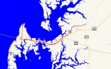
Maryland Route 18 (MD 18) is a state highway
in the U.S. state
of Maryland
. The state highway runs 20.37 miles (32.8 km) from the beginning of state maintenance at Love Point
east to MD 213
in Centreville
. MD 18 is the main east–west local highway on Kent Island
and east to Centreville, serving the centers of Stevensville
, Chester
, Kent Narrows
, Grasonville
, and Queenstown
that are bypassed by U.S. Route 50
and US 301
. What is signed as MD 18 is actually a set of four suffixed highways: MD 18A, MD 18B, MD 18S, and MD 18C. There are also several unsigned segments of MD 18 scattered along the length of the signed portions.
What is now MD 18 was first paved in the 1910s from Centreville to Queenstown along with short segments in Grasonville and Chester. Gaps in the Stevensville–Queenstown highway were filled throughout the 1920s, leaving only a crossing of Kent Narrows to be completed in the early 1930s. MD 18 between Stevensville and Love Point was constructed in the early 1930s. The Stevensville–Queenstown highway was designated part of MD 404
, while the highways on both ends to Love Point and Centreville were designated MD 18. US 50 replaced MD 404 when the former highway was extended east of Annapolis
in 1949. When US 50 was relocated as a divided highway between the Chesapeake Bay Bridge
and Queenstown in the early 1950s, MD 18 was assigned to the bypassed highway. Since the mid-1980s, several suffixed sections of MD 18 have been created, relocated, or received new designations due to expansion of US 50 and US 301 to a freeway.
at Castle Marina Road in Chester. MD 18B extends 7.94 miles (12.8 km) from the same roundabout east through Chester, Kent Narrows, and Grasonville to US 50 in Queenstown. MD 18S has a length of 0.33 mile (0.5310822 km) between US 50 and US 301 in Queenstown. MD 18C comprises the easternmost 6.71 miles (10.8 km) of the highway from US 301 in Queenstown to MD 213 in Centreville.
MD 18A's western terminus is at the beginning of state maintenance on Love Point Road just south of the community of Love Point at the northern end of Kent Island. The state highway heads due south through farmland. After meeting Old Love Point Road at an acute angle, MD 18A passes suburban subdivisions and Kent Island High School
. Love Point Road, which is unsigned
MD 835C
, veers southeast to pass through the Stevensville Historic District
, which contains the historic Cray House, the Stevensville Bank
building, and Christ Church. MD 18A curves to the southwest as Business Parkway. The state highway expands to a four-lane divided highway ahead of the intersection with MD 8
. MD 8 continues south on the divided highway toward an interchange with US 50 and US 301 (Blue Star Memorial Highway) just east of the Chesapeake Bay Bridge
while MD 18A turns east onto Main Street. MD 18A curves around the southern edge of the Stevensville Historic District, intersecting Love Point Road, which is unsigned MD 759B to the south, and the other end of MD 835C (East Main Street). The state highway passes Stevensville Middle School, crosses Cox Creek, and passes the Kent Island Shopping Center before reaching its eastern terminus at a roundabout with Castle Marina Road, which is unsigned MD 18H to the south.
MD 18B begins at the same roundabout at which MD 18A has its eastern terminus. Piney Creek Road, which is unsigned MD 18T, splits to the east as MD 18B curves southeast and crosses over US 50 and US 301. The state highway curves east again at an intersection with its old alignment, Postal Road, in Chester shortly before an intersection with MD 552
(Dominion Road). MD 18B continues around the south end of Piney Creek before entering the hamlet of Kent Narrows, where the highway has a direct connection to eastbound US 50 and US 301. The state highway also has an indirect connection to the westbound freeway via Piney Narrows Road immediately before crossing Kent Narrows on a drawbridge adjacent to the US 50 and US 301 crossing of the strait. MD 18B continues east through Grasonville, where the highway intersects Chester River Beach Road (unsigned MD 18V) and Nesbit Road (unsigned MD 835K), both of which provide full access to the freeway. The state highway continues through farmland before reaching its eastern terminus at US 50 (Ocean Gateway) just east of the US 50 – US 301 split in Queenstown. The two highways meet at a superstreet
intersection, so there is no direct access between MD 18B and MD 18S on the opposite side of the intersection.
MD 18S begins at US 50 opposite MD 18B's eastern terminus. At the intersection with MD 656 (Friels Road) and Outlet Center Drive, which heads into Prime Outlets Queenstown, the state highway turns north and reaches its eastern terminus at a superstreet intersection with US 301 (Blue Star Memorial Highway). MD 18C begins at US 301 opposite the eastern terminus of MD 18S. The state highway heads northeast as Main Street through the town of Queenstown, where the highway intersects MD 456
(Del Rhodes Avenue) and passes near the historic home Bowlingly
. After leaving the town, MD 18C's name changes to 4-H Park Road and the road passes through farmland. The state highway passes the namesake park of the youth agricultural organization
shortly after crossing Reed Creek. MD 18C passes by the historic home Bachelor's Hope
before the highway reaches its eastern terminus at MD 213 (Centreville Road) on the southwestern edge of Centreville.
When US 50 was extended to the Eastern Shore
in 1949, it was routed along MD 404 to Wye Mills. The US 50 divided highway started construction in 1950 and was completed between the Chesapeake Bay Bridge and Queenstown in 1952, including a new drawbridge over Kent Narrows. The 1933 bridge over Kent Narrows was dismantled in 1953. MD 18 was subsequently assigned to old US 50 between Stevensville and Queenstown, following its own alignment except for a concurrency
with US 50 and later US 301 over Kent Narrows.
Business Parkway was constructed in 1987 as a new alignment and northern extension of MD 8. MD 18 was extended west to Business Parkway and north on the divided highway to bypass the Stevensville Historic District in 1989; the old alignment was designated MD 835C. MD 18 also bypassed the center of Chester in 1989 by the construction of an overpass of US 50 and US 301 just west of MD 552, replacing the intersection at Castle Marina Road. The latter improvement was part of the transformation of US 50 and US 301 to a freeway from the Chesapeake Bay Bridge to Queenstown, which was completed in 1991. The upgrade included a new fixed high-level bridge over Kent Narrows for US 50 and US 301, relegating the 1952 drawbridge to be used only by MD 18. In 1999, MD 18 was relocated to the north to use a new roundabout at Castle Marina Road in Chester; the old mainline was designated MD 18R. The MD 18 – US 301 junction in Queenstown was transformed into a superstreet intersection in 2003, resulting in the splitting of the MD 18C designation; MD 18S was assigned to the highway south of the junction.
As part of the reconstruction of US 50 as a six-lane freeway from US 301 in Queenstown to MD 404 in Wye Mills, the Maryland State Highway Administration
plans to construct an overpass of MD 18 over US 50 in Queenstown. MD 18 and US 50 would become connected by a pair of right-in/right-out
interchanges. Access to eastbound US 50 would be via a new service road south of US 50 and connections with westbound US 50 would be made through Outlet Center Drive. As of 2011, the project has not been funded.
.
{| class=wikitable
!scope=col|Location
!scope=col|Mile
!scope=col|Destinations
!scope=col|Notes
|-
|Love Point
|0.00
|Love Point Road north
|Western terminus of MD 18A
|-
|rowspan=4|Stevensville
|3.01
|Love Point Road south – Stevensville Historic District
|Unsigned MD 835C
|-
|3.55
|
|MD 18A turns east onto Main Street
|-
|3.80
|Love Point Road
|Love Point Road south is unsigned MD 759B
|-
|3.95
|East Main Street west
|Unsigned MD 835C
|-
|rowspan=3|Chester
|5.39
|Castle Marina Road
|Roundabout
; Castle Marina Road south is unsigned MD 18H; eastern terminus of MD 18A; western terminus of MD 18B
|-
|5.50
|Piney Creek Road east
|Unsigned MD 18T
|-
|6.00
|
|
|-
|rowspan=3|Kent Narrows
|7.46
|
|
|-
|7.72
|Piney Narrows Road north to
|
|-
|7.97
|colspan=2 align=center|Old Kent Narrows Bridge – Kent Narrows
|-
|rowspan=3|Grasonville
|9.45
|
|Unsigned MD 18F
|-
|10.00
|Chester River Beach Road to
|Unsigned MD 18V
|-
|10.87
|Nesbit Road to
|Unsigned MD 835K
|-
|rowspan=4|Queenstown
|13.33
|
|Superstreet
intersection; eastern terminus of MD 18B; western terminus of MD 18S
|-
|13.61
|
|MD 18S turns north
|-
|13.66
|, Wilmington
|Superstreet
intersection; eastern terminus of MD 18S; western terminus of MD 18C
|-
|14.11
|
|Officially MD 456A
|-
|Centreville
|20.37
|
|Eastern terminus of MD 18C
State highway
State highway, state road or state route can refer to one of three related concepts, two of them related to a state or provincial government in a country that is divided into states or provinces :#A...
in the U.S. state
U.S. state
A U.S. state is any one of the 50 federated states of the United States of America that share sovereignty with the federal government. Because of this shared sovereignty, an American is a citizen both of the federal entity and of his or her state of domicile. Four states use the official title of...
of Maryland
Maryland
Maryland is a U.S. state located in the Mid Atlantic region of the United States, bordering Virginia, West Virginia, and the District of Columbia to its south and west; Pennsylvania to its north; and Delaware to its east...
. The state highway runs 20.37 miles (32.8 km) from the beginning of state maintenance at Love Point
Love Point, Maryland
Love Point is the name for the northernmost tip of Kent Island, and as such, marks the southern point of the mouth of the Chester River. It has served as a major ferry terminal, the western terminus of the Queen Anne's Railroad, and the nominal western terminus of Maryland Route 18...
east to MD 213
Maryland Route 213
Maryland Route 213 is a state highway located on the Eastern Shore of Maryland in the United States. The route runs from Maryland Route 662 in Wye Mills, Queen Anne's County north to the Pennsylvania border in Cecil County, where it continues into that state as Pennsylvania Route 841...
in Centreville
Centreville, Maryland
Centreville is an incorporated town in Queen Anne's County, Maryland, United States. Incorporated in 1794, it is the county seat of Queen Anne's County. The population was 1,970 at the 2000 census. The ZIP code is 21617 and the area code is 410. The local telephone exchange is 758...
. MD 18 is the main east–west local highway on Kent Island
Kent Island, Maryland
Kent Island is the largest island in the Chesapeake Bay, and a historic place in Maryland. To the east, a narrow channel known as the Kent Narrows barely separates the island from the Delmarva Peninsula, and on the other side, the island is separated from Sandy Point, an area near Annapolis, by...
and east to Centreville, serving the centers of Stevensville
Stevensville, Maryland
Stevensville is a census-designated place in Queen Anne's County, Maryland, and is the county's most populous place among both CDPs and municipalities. The Stevensville Historic District is one of only two registered historic districts in the county, the other being the Centreville Historic...
, Chester
Chester, Maryland
Chester is a census-designated place on Kent Island in Queen Anne's County, Maryland, United States. The population was 3,723 at the 2000 census.-Geography:Chester is located at ....
, Kent Narrows
Kent Narrows
The Kent Narrows, also known as Kent Island Narrows and to local residents simply as the Narrows, is a waterway that connects the Chester River with the Eastern Bay and also separates Kent Island from the Delmarva Peninsula. It runs through the community of Kent Narrows, Maryland. The Kent...
, Grasonville
Grasonville, Maryland
Grasonville is a census-designated place in Queen Anne's County, Maryland, United States. The population was 2,193 at the 2000 census.-Geography:Grasonville is located at ....
, and Queenstown
Queenstown, Maryland
Queenstown is a town in Queen Anne's County, Maryland, United States. The population was 617 at the 2000 census.-Geography:Queenstown is located at ....
that are bypassed by U.S. Route 50
U.S. Route 50 in Maryland
U.S. Route 50 is a major east–west route of the U.S. Highway system, stretching just over from Ocean City, Maryland on the Atlantic Ocean to West Sacramento, California. In the U.S. state of Maryland, US 50 exists in two sections. The longer of these serves as a major route connecting...
and US 301
U.S. Route 301 in Maryland
U.S. Route 301 in Maryland is a major highway that runs from Delaware to the Governor Harry W. Nice Memorial Bridge into Virginia. It passes through three of Maryland's four main regions: the Eastern Shore, the Baltimore-Washington Metropolitan Area, and Southern Maryland...
. What is signed as MD 18 is actually a set of four suffixed highways: MD 18A, MD 18B, MD 18S, and MD 18C. There are also several unsigned segments of MD 18 scattered along the length of the signed portions.
What is now MD 18 was first paved in the 1910s from Centreville to Queenstown along with short segments in Grasonville and Chester. Gaps in the Stevensville–Queenstown highway were filled throughout the 1920s, leaving only a crossing of Kent Narrows to be completed in the early 1930s. MD 18 between Stevensville and Love Point was constructed in the early 1930s. The Stevensville–Queenstown highway was designated part of MD 404
Maryland Route 404
Maryland Route 404 is a major highway on Maryland's Eastern Shore in the United States. It runs from Maryland Route 662 in Wye Mills on the border of Queen Anne's and Talbot Counties, southeast to the Delaware state line in Caroline County, where the road continues as Delaware Route 404 to Nassau...
, while the highways on both ends to Love Point and Centreville were designated MD 18. US 50 replaced MD 404 when the former highway was extended east of Annapolis
Annapolis, Maryland
Annapolis is the capital of the U.S. state of Maryland, as well as the county seat of Anne Arundel County. It had a population of 38,394 at the 2010 census and is situated on the Chesapeake Bay at the mouth of the Severn River, south of Baltimore and about east of Washington, D.C. Annapolis is...
in 1949. When US 50 was relocated as a divided highway between the Chesapeake Bay Bridge
Chesapeake Bay Bridge
The Chesapeake Bay Bridge is a major dual-span bridge in the U.S. state of Maryland. Spanning the Chesapeake Bay, it connects the state's rural Eastern Shore region with the more urban Western Shore. The original span opened in 1952 and, at the time, with a length of , it was the world's longest...
and Queenstown in the early 1950s, MD 18 was assigned to the bypassed highway. Since the mid-1980s, several suffixed sections of MD 18 have been created, relocated, or received new designations due to expansion of US 50 and US 301 to a freeway.
Route description
The mainline of MD 18 consists of four internally suffixed sections. MD 18A runs 5.39 miles (8.7 km) from Love Point south and east through Stevensville to a roundaboutRoundabout
A roundabout is the name for a road junction in which traffic moves in one direction around a central island. The word dates from the early 20th century. Roundabouts are common in many countries around the world...
at Castle Marina Road in Chester. MD 18B extends 7.94 miles (12.8 km) from the same roundabout east through Chester, Kent Narrows, and Grasonville to US 50 in Queenstown. MD 18S has a length of 0.33 mile (0.5310822 km) between US 50 and US 301 in Queenstown. MD 18C comprises the easternmost 6.71 miles (10.8 km) of the highway from US 301 in Queenstown to MD 213 in Centreville.
MD 18A's western terminus is at the beginning of state maintenance on Love Point Road just south of the community of Love Point at the northern end of Kent Island. The state highway heads due south through farmland. After meeting Old Love Point Road at an acute angle, MD 18A passes suburban subdivisions and Kent Island High School
Kent Island High School
Kent Island High School is a public high school in Stevensville, Maryland that first opened in 1998 to accommodate the growing population of Queen Anne's County...
. Love Point Road, which is unsigned
Unsigned highway
An unsigned highway is a highway that has been assigned a route number, but does not bear conventional road markings that would normally be used to identify the route with that number...
MD 835C
Maryland Route 835
-External links:*...
, veers southeast to pass through the Stevensville Historic District
Stevensville Historic District
The Stevensville Historic District, also known as Historic Stevensville, is a national historic district in downtown Stevensville, Queen Anne's County, Maryland. It contains roughly 100 historic structures, and is listed on the National Register of Historic Places...
, which contains the historic Cray House, the Stevensville Bank
Stevensville Bank
The Stevensville Bank is a historic building located near the center of Stevensville, Maryland, United States, and is in the Stevensville Historic District. The building's name is a reference to Stevensville Savings Bank which once occupied the building...
building, and Christ Church. MD 18A curves to the southwest as Business Parkway. The state highway expands to a four-lane divided highway ahead of the intersection with MD 8
Maryland Route 8
Maryland Route 8 is a state highway in the U.S. state of Maryland. Known for most of its length as Romancoke Road, the state highway runs from Romancoke Pier in Romancoke north to MD 18 in Stevensville. MD 8 is the main north–south highway of Kent Island in western Queen Anne's County. ...
. MD 8 continues south on the divided highway toward an interchange with US 50 and US 301 (Blue Star Memorial Highway) just east of the Chesapeake Bay Bridge
Chesapeake Bay Bridge
The Chesapeake Bay Bridge is a major dual-span bridge in the U.S. state of Maryland. Spanning the Chesapeake Bay, it connects the state's rural Eastern Shore region with the more urban Western Shore. The original span opened in 1952 and, at the time, with a length of , it was the world's longest...
while MD 18A turns east onto Main Street. MD 18A curves around the southern edge of the Stevensville Historic District, intersecting Love Point Road, which is unsigned MD 759B to the south, and the other end of MD 835C (East Main Street). The state highway passes Stevensville Middle School, crosses Cox Creek, and passes the Kent Island Shopping Center before reaching its eastern terminus at a roundabout with Castle Marina Road, which is unsigned MD 18H to the south.
MD 18B begins at the same roundabout at which MD 18A has its eastern terminus. Piney Creek Road, which is unsigned MD 18T, splits to the east as MD 18B curves southeast and crosses over US 50 and US 301. The state highway curves east again at an intersection with its old alignment, Postal Road, in Chester shortly before an intersection with MD 552
Maryland Route 552
Maryland Route 552 is a state highway in the U.S. state of Maryland. The state highway runs from Dominion north to U.S. Route 50 and US 301 in Chester. MD 552 was constructed south of Maryland Route 18 in the early 1930s...
(Dominion Road). MD 18B continues around the south end of Piney Creek before entering the hamlet of Kent Narrows, where the highway has a direct connection to eastbound US 50 and US 301. The state highway also has an indirect connection to the westbound freeway via Piney Narrows Road immediately before crossing Kent Narrows on a drawbridge adjacent to the US 50 and US 301 crossing of the strait. MD 18B continues east through Grasonville, where the highway intersects Chester River Beach Road (unsigned MD 18V) and Nesbit Road (unsigned MD 835K), both of which provide full access to the freeway. The state highway continues through farmland before reaching its eastern terminus at US 50 (Ocean Gateway) just east of the US 50 – US 301 split in Queenstown. The two highways meet at a superstreet
Superstreet
A superstreet is a type of road intersection that is a variation of the Michigan left. In this configuration, traffic on the minor road is not permitted to proceed straight across the major road or highway; traffic wishing to turn left or go straight must turn right onto the major road, make a...
intersection, so there is no direct access between MD 18B and MD 18S on the opposite side of the intersection.
MD 18S begins at US 50 opposite MD 18B's eastern terminus. At the intersection with MD 656 (Friels Road) and Outlet Center Drive, which heads into Prime Outlets Queenstown, the state highway turns north and reaches its eastern terminus at a superstreet intersection with US 301 (Blue Star Memorial Highway). MD 18C begins at US 301 opposite the eastern terminus of MD 18S. The state highway heads northeast as Main Street through the town of Queenstown, where the highway intersects MD 456
Maryland Route 456
Maryland Route 456 is a state highway in the U.S. state of Maryland. Known as Del Rhodes Avenue, the state highway runs from U.S. Route 50 north to MD 18 within Queenstown...
(Del Rhodes Avenue) and passes near the historic home Bowlingly
Bowlingly
Bowlingly, also known as Neale's Residence and The Ferry House, is a historic home located at Queenstown, Queen Anne's County, Maryland, United States. It is a large brick dwelling house constructed in 1733. The original house is a two story brick structure that is seven bays long and one room...
. After leaving the town, MD 18C's name changes to 4-H Park Road and the road passes through farmland. The state highway passes the namesake park of the youth agricultural organization
4-H
4-H in the United States is a youth organization administered by the National Institute of Food and Agriculture of the United States Department of Agriculture , with the mission of "engaging youth to reach their fullest potential while advancing the field of youth development." The name represents...
shortly after crossing Reed Creek. MD 18C passes by the historic home Bachelor's Hope
Bachelor's Hope (Centreville, Maryland)
Bachelor's Hope is a historic house in Centreville, Maryland. Built between 1798 and 1815, it was added to the National Register of Historic Places in 1984.-Architecture:...
before the highway reaches its eastern terminus at MD 213 (Centreville Road) on the southwestern edge of Centreville.
History
The first sections of MD 18 was paved as three separate state-aid roads within Queenstown and Grasonville by 1915, and between Stevensville and Chester shortly after 1915. The first section paved as a state road was between Centreville and Queenstown by 1919; there were also short pieces of state road paved in Chester and east of Grasonville by 1921. The state road in Chester was extended east to Kent Narrows and the state road road near Grasonville was extended west through the village in 1923. The Stevensville–Chester road and the Queenstown–Centreville road were marked as MD 18 by 1927. The road from Stevensville to Love Point was started in 1929 and completed to just south of Love Point in 1930. The highway was extended to its present western terminus by 1933. Pavement was also laid from the west end of Grasonville to Kent Narrows by 1930. The east–west highway between Stevensville and Queenstown was finished with the completion of a timber trestle bascule bridge over Kent Narrows. That highway was marked as MD 404 in 1933; the highways from Stevensville to Love Point and from Queenstown to Centreville remained marked as MD 18.When US 50 was extended to the Eastern Shore
Eastern Shore of Maryland
The Eastern Shore of Maryland is a territorial part of the U.S. state of Maryland that lies predominately on the east side of the Chesapeake Bay and consists of nine counties. The origin of term Eastern Shore was derived to distinguish a territorial part of the State of Maryland from the Western...
in 1949, it was routed along MD 404 to Wye Mills. The US 50 divided highway started construction in 1950 and was completed between the Chesapeake Bay Bridge and Queenstown in 1952, including a new drawbridge over Kent Narrows. The 1933 bridge over Kent Narrows was dismantled in 1953. MD 18 was subsequently assigned to old US 50 between Stevensville and Queenstown, following its own alignment except for a concurrency
Concurrency (road)
A concurrency, overlap, or coincidence in a road network is an instance of one physical road bearing two or more different highway, motorway, or other route numbers...
with US 50 and later US 301 over Kent Narrows.
Business Parkway was constructed in 1987 as a new alignment and northern extension of MD 8. MD 18 was extended west to Business Parkway and north on the divided highway to bypass the Stevensville Historic District in 1989; the old alignment was designated MD 835C. MD 18 also bypassed the center of Chester in 1989 by the construction of an overpass of US 50 and US 301 just west of MD 552, replacing the intersection at Castle Marina Road. The latter improvement was part of the transformation of US 50 and US 301 to a freeway from the Chesapeake Bay Bridge to Queenstown, which was completed in 1991. The upgrade included a new fixed high-level bridge over Kent Narrows for US 50 and US 301, relegating the 1952 drawbridge to be used only by MD 18. In 1999, MD 18 was relocated to the north to use a new roundabout at Castle Marina Road in Chester; the old mainline was designated MD 18R. The MD 18 – US 301 junction in Queenstown was transformed into a superstreet intersection in 2003, resulting in the splitting of the MD 18C designation; MD 18S was assigned to the highway south of the junction.
As part of the reconstruction of US 50 as a six-lane freeway from US 301 in Queenstown to MD 404 in Wye Mills, the Maryland State Highway Administration
Maryland State Highway Administration
The Maryland State Highway Administration is the state agency responsible for maintaining Maryland numbered highways outside of Baltimore City...
plans to construct an overpass of MD 18 over US 50 in Queenstown. MD 18 and US 50 would become connected by a pair of right-in/right-out
Right-in/right-out
Right-in/right-out and left-in/left-out refer to a type of road intersection where turning movements of vehicles are restricted. A RIRO permits only right turns and a LILO permits only left turns. RIRO is usual where vehicles drive on the right, and LILO is usual where vehicles drive on the left...
interchanges. Access to eastbound US 50 would be via a new service road south of US 50 and connections with westbound US 50 would be made through Outlet Center Drive. As of 2011, the project has not been funded.
Junction list
The entire route is in Queen Anne's CountyQueen Anne's County, Maryland
Queen Anne's County is a county located on the Eastern Shore of the U.S. state of Maryland.As of 2010, the population was 47,798. Its county seat and most populous municipality is Centreville. The census-designated place of Stevensville is the county's most populous place...
.
{| class=wikitable
!scope=col|Location
!scope=col|Mile
!scope=col|Destinations
!scope=col|Notes
|-
|Love Point
Love Point, Maryland
Love Point is the name for the northernmost tip of Kent Island, and as such, marks the southern point of the mouth of the Chester River. It has served as a major ferry terminal, the western terminus of the Queen Anne's Railroad, and the nominal western terminus of Maryland Route 18...
|0.00
|Love Point Road north
|Western terminus of MD 18A
|-
|rowspan=4|Stevensville
Stevensville, Maryland
Stevensville is a census-designated place in Queen Anne's County, Maryland, and is the county's most populous place among both CDPs and municipalities. The Stevensville Historic District is one of only two registered historic districts in the county, the other being the Centreville Historic...
|3.01
|Love Point Road south – Stevensville Historic District
Stevensville Historic District
The Stevensville Historic District, also known as Historic Stevensville, is a national historic district in downtown Stevensville, Queen Anne's County, Maryland. It contains roughly 100 historic structures, and is listed on the National Register of Historic Places...
|Unsigned MD 835C
Maryland Route 835
-External links:*...
|-
|3.55
|
|MD 18A turns east onto Main Street
|-
|3.80
|Love Point Road
|Love Point Road south is unsigned MD 759B
|-
|3.95
|East Main Street west
|Unsigned MD 835C
Maryland Route 835
-External links:*...
|-
|rowspan=3|Chester
Chester, Maryland
Chester is a census-designated place on Kent Island in Queen Anne's County, Maryland, United States. The population was 3,723 at the 2000 census.-Geography:Chester is located at ....
|5.39
|Castle Marina Road
|Roundabout
Roundabout
A roundabout is the name for a road junction in which traffic moves in one direction around a central island. The word dates from the early 20th century. Roundabouts are common in many countries around the world...
; Castle Marina Road south is unsigned MD 18H; eastern terminus of MD 18A; western terminus of MD 18B
|-
|5.50
|Piney Creek Road east
|Unsigned MD 18T
|-
|6.00
|
|
|-
|rowspan=3|Kent Narrows
Kent Narrows, Maryland
Kent Narrows is a census-designated place and town in Queen Anne's County, Maryland, United States. As of the 2000 census, the town had a population of 567.-Geography:Kent Narrows is located at ....
|7.46
|
|
|-
|7.72
|Piney Narrows Road north to
|
|-
|7.97
|colspan=2 align=center|Old Kent Narrows Bridge – Kent Narrows
Kent Narrows
The Kent Narrows, also known as Kent Island Narrows and to local residents simply as the Narrows, is a waterway that connects the Chester River with the Eastern Bay and also separates Kent Island from the Delmarva Peninsula. It runs through the community of Kent Narrows, Maryland. The Kent...
|-
|rowspan=3|Grasonville
Grasonville, Maryland
Grasonville is a census-designated place in Queen Anne's County, Maryland, United States. The population was 2,193 at the 2000 census.-Geography:Grasonville is located at ....
|9.45
|
|Unsigned MD 18F
|-
|10.00
|Chester River Beach Road to
|Unsigned MD 18V
|-
|10.87
|Nesbit Road to
|Unsigned MD 835K
Maryland Route 835
-External links:*...
|-
|rowspan=4|Queenstown
Queenstown, Maryland
Queenstown is a town in Queen Anne's County, Maryland, United States. The population was 617 at the 2000 census.-Geography:Queenstown is located at ....
|13.33
|
|Superstreet
Superstreet
A superstreet is a type of road intersection that is a variation of the Michigan left. In this configuration, traffic on the minor road is not permitted to proceed straight across the major road or highway; traffic wishing to turn left or go straight must turn right onto the major road, make a...
intersection; eastern terminus of MD 18B; western terminus of MD 18S
|-
|13.61
|
|MD 18S turns north
|-
|13.66
|, Wilmington
Wilmington, Delaware
Wilmington is the largest city in the state of Delaware, United States, and is located at the confluence of the Christina River and Brandywine Creek, near where the Christina flows into the Delaware River. It is the county seat of New Castle County and one of the major cities in the Delaware Valley...
|Superstreet
Superstreet
A superstreet is a type of road intersection that is a variation of the Michigan left. In this configuration, traffic on the minor road is not permitted to proceed straight across the major road or highway; traffic wishing to turn left or go straight must turn right onto the major road, make a...
intersection; eastern terminus of MD 18S; western terminus of MD 18C
|-
|14.11
|
|Officially MD 456A
|-
|Centreville
Centreville, Maryland
Centreville is an incorporated town in Queen Anne's County, Maryland, United States. Incorporated in 1794, it is the county seat of Queen Anne's County. The population was 1,970 at the 2000 census. The ZIP code is 21617 and the area code is 410. The local telephone exchange is 758...
|20.37
|
|Eastern terminus of MD 18C
Auxiliary routes
MD 18 has 12 unsigned auxiliary routes. MD 18F, MD 18I, and MD 18U through MD 18Z are in Grasonville. MD 18G is in Queenstown. MD 18H, MD 18R, and MD 18T are in Chester.- MD 18F is the designation for an unnamed 0.03 mile (0.0482802 km) connector between MD 18B and a right-in/right-out interchange (Exit 43A) with eastbound US 50 and US 301 between Kent Narrows and Grasonville.
- MD 18G is the designation for Links Lane, a 0.06 mile (0.0965604 km) section of old alignment of MD 18 just north of MD 18C's western terminus in Queenstown that serves as the entrance to Queenstown Harbor Golf Links.
- MD 18H is the designation for a 0.19 mile (0.3057746 km) section of Castle Marina Road between a right-in/right-out interchange (Exit 39A) with westbound US 50 and US 301 and the roundabout that serves as a terminus for both MD 18A and MD 18B in Chester.
- MD 18I is the designation for a 0.04 mile (0.0643736 km) segment of Station Lane that connects with a right-in/right-out interchange (Exit 44A) with eastbound US 50 and US 301.
- MD 18R is the designation for a former alignment of MD 18A/Main Street, a 0.32 mile (0.5149888 km) highway between MD 18A and MD 18H that serves a park and ridePark and ridePark and ride facilities are car parks with connections to public transport that allow commuters and other people wishing to travel into city centres to leave their vehicles and transfer to a bus, rail system , or carpool for the rest of their trip...
facility and other businesses in Chester. - MD 18T is the designation for a 0.38 mi (0.6115492 km) stretch of Piney Creek Road between MD 18B and MD 552A (Chester Station Road) in Chester.
- MD 18U is the designation for a 0.02 mile (0.0321868 km) section of Jackson Creek Road that serves as the ramps of the right-in/right-out interchange (Exit 43A) between the intersection of Jackson Creek Road, Saddler Road (unsigned MD 835B), and Long Point Road and westbound US 50 and US 301 in Grasonville.
- MD 18V is the designation for a 0.65 miles (1 km) section of Chester River Beach Road between MD 18B and a point just north of Loblolly Way in Grasonville. MD 18V features a partial interchange with US 50 and US 301 (Exit 43B).
- MD 18W is the designation for VFW Avenue, a 0.33 mile (0.5310822 km) road between a right-in/right-out interchange (Exit 44A) with westbound US 50 and US 301 and MD 18V in Grasonville. The highway is state-maintained at both ends, with the middle stretch maintained by Queen Anne's County.
- MD 18X is the designation for a 0.07 mile (0.1126538 km) segment of Hess Road between MD 18Y and a right-in/right-out interchange (Exit 45A) with eastbound US 50 and US 301 in Grasonville.
- MD 18Y is the designation for Hess Frontage Road, a 0.11 mile (0.1770274 km) spur that parallels the eastbound side of US 50 and US 301 east of MD 18X in Grasonville.
- MD 18Z is the designation for a 0.03 mile (0.0482802 km) portion of Evans Avenue adjacent to a right-in/right-out interchange (Exit 44B) with eastbound US 50 and US 301 in Grasonville.