

Maryland Route 16
Encyclopedia
Maryland Route 16 (MD 16) is a state highway
in the U.S. state
of Maryland
. The state highway runs 51.06 miles (82.2 km) from Taylors Island east to the Delaware
state line in Hickman
, where the highway continues as Delaware Route 16 (DE 16). MD 16 connects Cambridge
with several communities in northern Dorchester County
and southwestern Caroline
, including East New Market
and Preston
. The state highway runs concurrently
with U.S. Route 50
(US 50) near Cambridge, MD 331
between East New Market and Preston, and both MD 404
and MD 313
near Andersontown
. The state highway is a part of the National Highway System
along its concurrencies with US 50 and MD 404. MD 16 was constructed between Church Creek
and Preston as one of the original state roads in the early and mid-1910s. The highway was extended in both directions in the late 1910s: north to what was to be designated MD 313 near Denton
and west to Taylors Island. MD 16 was extended through Andersontown to the Delaware state line in the early 1930s. MD 16's bypass of Cambridge was constructed in the mid-1960s.
, Grace Episcopal Church Complex
, and Bethlehem Methodist Episcopal Church
. MD 16 heads northeast from the island as two-lane Taylors Island Road. The state highway crosses Parsons Creek and passes through the hamlets of Madison
and Woolford
on its way to the town of Church Creek, where MD 16 intersects MD 335
(Golden Hill Road). MD 16 continues northeast as Church Creek Road toward Cambridge, where the state highway intersects MD 341
(Race Street), which is the old alignment of MD 16, just beyond Cambridge-South Dorchester High School
along the southern edge of the city. MD 16 continues east and intersects the Seaford Line of the Maryland and Delaware Railroad
, then curves north to US 50 (Ocean Gateway). The state highway joins US 50 in a concurrency along the four-lane divided highway. US 50 and MD 16 intersect Bucktown Road, which leads southeast to Cambridge-Dorchester Airport
, and both ends of MD 750 (Old Route 50) before reaching the eastern end of the concurrency in the community of Whitehall
, also known as Mount Holly.
MD 16 heads northeast from US 50 as two-lane Mount Holly Road. As the state highway approaches East New Market, the western terminus of MD 14
(Secretary Road) heads north toward Secretary
and MD 392
(East New Market Bypass) heads northeast toward Hurlock
. MD 16 turns north into the town, where the highway passes through the East New Market Historic District
as Main Street. The state highway intersects MD 14 (Railroad Avenue) before leaving town as East New Market Ellwood Road. MD 16 crosses the Warwick River and Cabin Creek before meeting MD 331 (Waddells Corner Road) at Waddells Corner
. MD 16 joins MD 331 in a concurrency that crosses Gravel Creek and passes Beulah Road, the old alignment of MD 16 and MD 331 through Ellwood. After an at-grade crossing of the Preston Branch of the Seaford Line of the Maryland and Delaware Railroad, the two state highways intersect MD 318
(Preston Road) and continue northwest as Preston Road, which passes near the Jacob and Hannah Leverton House
before crossing Hunting Creek into Caroline County.
 The MD 16–MD 331 concurrency continues northwest through Linchester
, where the highway passes both ends of MD 817 (Linchester Road), which provides access to the historic Linchester Mill
. The state highways continue through the town of Preston as Main Street. Unsigned MD 324 (Maple Avenue) heads south from MD 16 and MD 331 before the two highways split on the west side of town. MD 16 heads north as Harmony Road through the hamlet of Grove
and intersects MD 578
(Bethlehem Road) in the community of Harmony
. The state highway crosses Fowling Creek and Robins Creek and passes through the hamlet of Two Johns, which is also known as Bureau.
As MD 16 passes to the west of Williston Lake, an impoundment of Mill Creek, the highway closely parallels its old alignment, MD 617. The state highway passes through the Williston Mill Historic District
just east of the community of Williston
, which contains the historic homes Potter Hall
and Memory Lane
. MD 16 continues northeast until reaching an intersection with MD 404 and MD 313 (Shore Highway) south of Denton. MD 16 turns southeast onto Shore Highway, a four-lane divided highway that reduces to two lanes east of the intersection, to form a triple state highway concurrency. The three state highways continue east to Andersontown, where MD 313 heads south as Federalsburg Highway. A short distance to the east, MD 404 continues straight southeast while MD 16 turns northeast onto Greenwood Road. Shortly thereafter, MD 16 reaches its eastern terminus at the Delaware state line in Hickman. The highway continues east as DE 16 (Hickman Road) toward Greenwood
.
in 1909. The portion of the highway between Bureau and the western junction with MD 313 and MD 404 south of Denton was also included in the planned state road system; that piece of highway was the first part of modern MD 16 completed in 1910. MD 16 was completed from Mount Holly to East New Market in 1911, from Cambridge to Mount Holly in 1913, from East New Market to Preston via Linchester in 1914, and from Church Creek to Cambridge in 1915. The gap in the state highway within East New Market was closed in 1917. The segment of highway between Preston and Grove was surfaced by 1915. MD 16 between Grove and Bureau was under construction by 1919 and finished around 1920. The state highway was constructed from the bridge to Taylor's Island to Church Creek between 1917 and 1919.
When numbers were assigned to state highways in Maryland in 1927, MD 16 had a concurrency with US 213 between Waddell's Corner and Preston. Greenwood Road from MD 404 in Andersontown to the Delaware state line was built between 1930 and 1933, concurrent with the completion of the connecting section of MD 404. MD 16 was extended north and east through Andersontown to the Delaware state line by 1939, giving the state highway additional concurrencies with MD 313 and MD 404. Also in 1939, US 213 between Easton
and Vienna
was transferred to a new route via Cambridge; the old portion of US 213 was designated MD 331 and the new section of US 213 became concurrent with MD 16 between Cambridge and Mount Holly. Within Cambridge, MD 16 followed Race Street north to Washington Street, which the highway followed east toward Mount Holly.
The next changes in MD 16 occurred in the 1950s. MD 16 was extended west across Slaughter Creek to Taylors Island when a new bridge was completed in 1950. MD 313 was moved to its present alignment between Federalsburg and Denton in 1954; as a result, MD 16 became the sole route from Bureau to MD 404 south of Denton and part of a triple concurrency from there to Andersontown. US 50, which had replaced US 213 from Ocean City
to Wye Mills
in 1949, was expanded to a divided highway along its concurrency with MD 16 by 1955. MD 331 and MD 16 were realigned around Ellwood and Linchester around 1960. MD 16 was relocated to bypass Cambridge in 1967; the state highway's old route through the city was transferred to newly designated MD 341 and an extension of MD 343
east to US 50. MD 16 was relocated at Williston Lake shortly after the construction of a new bridge across the lake's outlet, Mill Creek, in 1968. The state highway was straightened out through Madison in 1970, leaving behind Old Madison Road.
!scope=col|County
!scope=col|Location
!scope=col|Mile
!scope=col|Destinations
!scope=col|Notes
|-
|rowspan=12|Dorchester
|Taylors Island
|0.00
|Hoopers Neck Road west
|Western terminus
|-
|Church Creek
|9.56
|
|
|-
|rowspan=4|Cambridge
|14.60
|
|
|-
|16.90
|
|West end of concurrency with US 50
|-
|17.31
|
|
|-
|18.11
|
|
|-
|Whitehall
|19.56
|
|East end of concurrency with US 50
|-
|rowspan=3|East New Market
|23.52
|
|
|-
|24.41
|
|
|-
|25.17
|
|
|-
|Waddells Corner
|29.15
|
|West end of concurrency with MD 331
|-
|rowspan=2|Linchester
|32.47
|
|
|-
|rowspan=9|Caroline
|32.69
|
|rowspan=2|Officially MD 817A
|-
|rowspan=3|Preston
|33.11
|
|-
|33.66
|Maple Avenue south – Choptank
|Unsigned MD 324
|-
|33.73
|
|East end of concurrency with MD 331
|-
|Harmony
|38.85
|
|
|-
|Denton
|45.39
|
|West end of concurrency with MD 404 / MD 313
|-
|rowspan=2|Andersontown
|47.67
|
|East end of concurrency with MD 313
|-
|48.56
|
|East end of concurrency with MD 404
|-
|Hickman
|51.06
|
|Eastern terminus; Delaware
state line
State highway
State highway, state road or state route can refer to one of three related concepts, two of them related to a state or provincial government in a country that is divided into states or provinces :#A...
in the U.S. state
U.S. state
A U.S. state is any one of the 50 federated states of the United States of America that share sovereignty with the federal government. Because of this shared sovereignty, an American is a citizen both of the federal entity and of his or her state of domicile. Four states use the official title of...
of Maryland
Maryland
Maryland is a U.S. state located in the Mid Atlantic region of the United States, bordering Virginia, West Virginia, and the District of Columbia to its south and west; Pennsylvania to its north; and Delaware to its east...
. The state highway runs 51.06 miles (82.2 km) from Taylors Island east to the Delaware
Delaware
Delaware is a U.S. state located on the Atlantic Coast in the Mid-Atlantic region of the United States. It is bordered to the south and west by Maryland, and to the north by Pennsylvania...
state line in Hickman
Hickman, Maryland
Hickman is an unincorporated community in Caroline County, Maryland, United States. It straddles the border with Kent County, Delaware along Road 113.-References:...
, where the highway continues as Delaware Route 16 (DE 16). MD 16 connects Cambridge
Cambridge, Maryland
Cambridge is a city in Dorchester County, Maryland, United States. The population was 12,326 at the 2010 census. It is the county seat of Dorchester County and the county's largest municipality...
with several communities in northern Dorchester County
Dorchester County, Maryland
Dorchester County is a county located in the U.S. state of Maryland on its Eastern Shore. It is bordered by the Choptank River to the north, Talbot County to the northwest, Caroline County to the northeast, Wicomico County to the southeast, Sussex County, Delaware, to the east, and the Chesapeake...
and southwestern Caroline
Caroline County, Maryland
Caroline County is a wholly rural county located in the U.S. state of Maryland on its Eastern Shore. It is bordered by Queen Anne's County to the north, Talbot County to the west, Dorchester County to the south, Kent County, Delaware, to the east, and Sussex County, Delaware, to the southeast. As...
, including East New Market
East New Market, Maryland
East New Market is a town located in Dorchester County, Maryland. As of the 2000 census, the town had a total population of 167. The zip code is 21631.-Geography:East New Market is located at ....
and Preston
Preston, Maryland
Preston is a town in Caroline County, Maryland, United States. The population was 566 at the 2000 census. The ZIP code is 21655. The primary phone exchange is 673 and the area code is 410....
. The state highway runs concurrently
Concurrency (road)
A concurrency, overlap, or coincidence in a road network is an instance of one physical road bearing two or more different highway, motorway, or other route numbers...
with U.S. Route 50
U.S. Route 50 in Maryland
U.S. Route 50 is a major east–west route of the U.S. Highway system, stretching just over from Ocean City, Maryland on the Atlantic Ocean to West Sacramento, California. In the U.S. state of Maryland, US 50 exists in two sections. The longer of these serves as a major route connecting...
(US 50) near Cambridge, MD 331
Maryland Route 331
Maryland Route 331 is a state highway on the Eastern Shore of Maryland in the United States. The route runs from Vienna in Dorchester County northwest to Easton in Talbot County, intersecting U.S. Route 50 at both ends. MD 331 is a two-lane undivided road most of its length that passes mostly...
between East New Market and Preston, and both MD 404
Maryland Route 404
Maryland Route 404 is a major highway on Maryland's Eastern Shore in the United States. It runs from Maryland Route 662 in Wye Mills on the border of Queen Anne's and Talbot Counties, southeast to the Delaware state line in Caroline County, where the road continues as Delaware Route 404 to Nassau...
and MD 313
Maryland Route 313
Maryland Route 313 is a state highway located on the Eastern Shore of Maryland in the United States. The route runs from U.S. Route 50 in Mardela Springs, Wicomico County north to Maryland Route 213 and Maryland Route 290 in Galena, Kent County...
near Andersontown
Andersontown, Maryland
Andersontown, Maryland, is an unincorporated town on Maryland's Eastern Shore in Caroline County, Maryland, United States. It is near the Delaware line, centered around the intersection of Andersontown Road and Maryland Route 404.-References:...
. The state highway is a part of the National Highway System
National Highway System (United States)
The National Highway System is a network of strategic highways within the United States, including the Interstate Highway System and other roads serving major airports, ports, rail or truck terminals, railway stations, pipeline terminals and other strategic transport facilities.Individual states...
along its concurrencies with US 50 and MD 404. MD 16 was constructed between Church Creek
Church Creek, Maryland
Church Creek is a town in Dorchester County, Maryland, United States. The population was 85 at the 2000 census.-Geography:Church Creek is located at...
and Preston as one of the original state roads in the early and mid-1910s. The highway was extended in both directions in the late 1910s: north to what was to be designated MD 313 near Denton
Denton, Maryland
Denton is a town in Caroline County, Maryland, United States. The population was 2,960 at the 2000 census. It is the county seat of Caroline County. Denton is the birthplace of former Delaware governor Sherman W. Tribbitt and author Sophie Kerr, as well as the long time home of former Maryland...
and west to Taylors Island. MD 16 was extended through Andersontown to the Delaware state line in the early 1930s. MD 16's bypass of Cambridge was constructed in the mid-1960s.
Dorchester County
MD 16 begins on Taylors Island a short distance west of the bridge over Slaughter Creek to the mainland. The roadway continues west as county-maintained Hoopers Neck Road, which provides access to the historic Ridgeton FarmRidgeton Farm
Ridgeton Farm is a historic home located at Taylor's Island, Dorchester County, Maryland, United States. It is an Italianate style, two story home built about 1857-1860 by the local architect Fred Ridgeton, who was quite unknown in the region. The house features a hip roof with a center gable, a...
, Grace Episcopal Church Complex
Grace Episcopal Church Complex (Taylor's Island, Maryland)
The Grace Episcopal Church Complex is a historic Episcopal church located at Taylor's Island, Dorchester County, Maryland, United States. The complex consists of three frame structures: a schoolhouse, chapel of ease, and Grace Episcopal Church. The chapel of ease dates from the first quarter of the...
, and Bethlehem Methodist Episcopal Church
Bethlehem Methodist Episcopal Church
Bethlehem Methodist Episcopal Church is a historic Methodist church located at Taylor's Island, Dorchester County, Maryland. It was built in 1857, and is a gable-front common bond brick church across the road from a mid-19th century cemetery....
. MD 16 heads northeast from the island as two-lane Taylors Island Road. The state highway crosses Parsons Creek and passes through the hamlets of Madison
Madison, Maryland
Madison is an unincorporated community in Dorchester County, Maryland, United States.-References:...
and Woolford
Woolford, Maryland
Woolford is an unincorporated community in Dorchester County, Maryland, United States. Woolford is located on Maryland Route 16 west of Church Creek. Woolford has a post office with ZIP code 21677....
on its way to the town of Church Creek, where MD 16 intersects MD 335
Maryland Route 335
Maryland Route 335 is a state highway in the U.S. state of Maryland. The state highway runs from Honga on Upper Hooper Island north to MD 16 in Church Creek. MD 335 provides access to several communities along the Honga River in southern Dorchester County, including Hooper's Island. The state...
(Golden Hill Road). MD 16 continues northeast as Church Creek Road toward Cambridge, where the state highway intersects MD 341
Maryland Route 341
Maryland Route 341 is a state highway in the U.S. state of Maryland. Known as Race Street, the state highway runs from MD 16 north to MD 343 within the city of Cambridge. The part of Race Street that is now MD 341 was constructed in the mid 1910s as one of the original state roads and...
(Race Street), which is the old alignment of MD 16, just beyond Cambridge-South Dorchester High School
Cambridge-South Dorchester High School
Cambridge-South Dorchester High School is located in Cambridge, Maryland and is part of the Dorchester County Public Schools system, and serves students in grades 9 to 12. The School opened in 1976 and cost $9 Million Dollars to build and equip. The school's most prominent feature is that it was...
along the southern edge of the city. MD 16 continues east and intersects the Seaford Line of the Maryland and Delaware Railroad
Maryland and Delaware Railroad
The Maryland and Delaware Railroad Company is a Class III short-line railroad, formed in 1977 to operate several branch lines of the former Penn Central Railroad in both Maryland and Delaware. These branches were omitted from the system plan for Conrail in 1976 and would have been discontinued...
, then curves north to US 50 (Ocean Gateway). The state highway joins US 50 in a concurrency along the four-lane divided highway. US 50 and MD 16 intersect Bucktown Road, which leads southeast to Cambridge-Dorchester Airport
Cambridge-Dorchester Airport
Cambridge-Dorchester Airport is a county-owned, public-use airport located three nautical miles southeast of the central business district of Cambridge, in Dorchester County, Maryland, United States.- Facilities and aircraft :...
, and both ends of MD 750 (Old Route 50) before reaching the eastern end of the concurrency in the community of Whitehall
Whitehall, Dorchester County, Maryland
Whitehall is an unincorporated community in Dorchester County, Maryland, United States. Whitehall is east of Cambridge....
, also known as Mount Holly.
MD 16 heads northeast from US 50 as two-lane Mount Holly Road. As the state highway approaches East New Market, the western terminus of MD 14
Maryland Route 14
Maryland Route 14 is a state highway in the U.S. state of Maryland. The state highway runs from MD 16 in Secretary east to MD 313 in Eldorado. MD 14 connects those two towns with the towns of East New Market and Brookview in northern Dorchester County. The state highway also shares a...
(Secretary Road) heads north toward Secretary
Secretary, Maryland
Secretary is a town in Dorchester County, Maryland, United States. The population was 503 at the 2000 census.-Geography:Secretary is located at ....
and MD 392
Maryland Route 392
Maryland Route 392 is a state highway in the U.S. state of Maryland. The state highway runs from MD 16 in East New Market east to the Delaware state line in Reliance, where the highway continues east as Delaware Route 20 . MD 392 connects East New Market with Hurlock as well as Seaford,...
(East New Market Bypass) heads northeast toward Hurlock
Hurlock, Maryland
Hurlock is a town in Dorchester County, Maryland, United States. The population was 1,874 at the 2000 census. It is home to WAAI radio. Joyce Spratt is the current mayor, and the town has five council members—Michael E. Henry , Michael D. Nordstrom , Parker J. Durham , Charles T. Cephas and...
. MD 16 turns north into the town, where the highway passes through the East New Market Historic District
East New Market Historic District
East New Market Historic District is a national historic district in East New Market, Dorchester County, Maryland. It consists of a village of about 75 buildings that represent a variety of 18th, 19th, and 20th century architectural styles....
as Main Street. The state highway intersects MD 14 (Railroad Avenue) before leaving town as East New Market Ellwood Road. MD 16 crosses the Warwick River and Cabin Creek before meeting MD 331 (Waddells Corner Road) at Waddells Corner
Waddells Corner, Maryland
Waddells Corner is a populated place in Dorchester County, Maryland, United States. The name was collected by the United States Geological Survey between 1976 and 1979, and entered into the Geographic Names Information System on September 12, 1979.-References:...
. MD 16 joins MD 331 in a concurrency that crosses Gravel Creek and passes Beulah Road, the old alignment of MD 16 and MD 331 through Ellwood. After an at-grade crossing of the Preston Branch of the Seaford Line of the Maryland and Delaware Railroad, the two state highways intersect MD 318
Maryland Route 318
Maryland Route 318 is a state highway in the U.S. state of Maryland. The state highway runs from MD 16 and MD 331 near Preston east to the Delaware state line near Federalsburg, where the highway continues east as Delaware Route 18 . MD 318 follows the Dorchester–Caroline county line for...
(Preston Road) and continue northwest as Preston Road, which passes near the Jacob and Hannah Leverton House
Jacob and Hannah Leverton House
Jacob and Hannah Leverton House, also known as the Dyott Farm, is a historic home located at Linchester, near Preston, in Caroline County, Maryland, United States. It is a two-story side-passage-plan brick house with a gable roof constructed in the first quarter of the 19th century. A two-bay,...
before crossing Hunting Creek into Caroline County.
Caroline County
Linchester, Maryland
Linchester is an unincorporated place in Caroline County, Maryland. -Reference:...
, where the highway passes both ends of MD 817 (Linchester Road), which provides access to the historic Linchester Mill
Linchester Mill
Linchester Mill is a historic grist mill located at Preston in Caroline County, Maryland, United States. It was built about 1840 and is a -story frame building sided in red-painted weatherboard and roofed with raised-seam metal. It is four bays long and two bays deep, with a two-story lean-to...
. The state highways continue through the town of Preston as Main Street. Unsigned MD 324 (Maple Avenue) heads south from MD 16 and MD 331 before the two highways split on the west side of town. MD 16 heads north as Harmony Road through the hamlet of Grove
Grove, Maryland
Grove is an unincorporated community in Caroline County, Maryland, United States.-References:...
and intersects MD 578
Maryland Route 578
Maryland Route 578 is a state highway in the U.S. state of Maryland. Known as Bethlehem Road, the state highway runs from MD 331 in Bethlehem east to MD 16 in Harmony. The first segment of MD 578 was completed in the mid 1930s; the remainder was built in the early 1940s.-Route description:MD...
(Bethlehem Road) in the community of Harmony
Harmony, Maryland
Harmony is a small unincorporated community in Caroline County, Maryland, United States. It is little more than an intersection of state Routes 16 and 578 on Maryland's Eastern Shore...
. The state highway crosses Fowling Creek and Robins Creek and passes through the hamlet of Two Johns, which is also known as Bureau.
As MD 16 passes to the west of Williston Lake, an impoundment of Mill Creek, the highway closely parallels its old alignment, MD 617. The state highway passes through the Williston Mill Historic District
Williston Mill Historic District
Williston Mill Historic District is a national historic district in Denton, Caroline County, Maryland. It consists of two historic structures--a grist mill and a miller's house--which share the acreage with the mill stream and race that empties into Mill Creek, a tributary of the Choptank River...
just east of the community of Williston
Williston, Maryland
Williston, is an unincorporated town on the Eastern Shore of the U.S. state of Maryland, in Caroline County, Maryland, United States. It is on Maryland Route 16 as well as on the banks of the Choptank River. It was originally known as Potter's Landing for its first resident, Zabdiel Potter...
, which contains the historic homes Potter Hall
Potter Hall
Potter Hall is a historic home located at Williston, Caroline County, Maryland, United States. It is an early-19th-century, Federal-influenced house facing the Choptank River...
and Memory Lane
Memory Lane (Denton, Maryland)
Memory Lane is a historic home located at Denton, Caroline County, Maryland. It a -story, frame Italianate-style house constructed in 1864. Notable exterior features include extensive porches, decorative brackets, and an octagonal cupola...
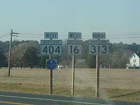
. MD 16 continues northeast until reaching an intersection with MD 404 and MD 313 (Shore Highway) south of Denton. MD 16 turns southeast onto Shore Highway, a four-lane divided highway that reduces to two lanes east of the intersection, to form a triple state highway concurrency. The three state highways continue east to Andersontown, where MD 313 heads south as Federalsburg Highway. A short distance to the east, MD 404 continues straight southeast while MD 16 turns northeast onto Greenwood Road. Shortly thereafter, MD 16 reaches its eastern terminus at the Delaware state line in Hickman. The highway continues east as DE 16 (Hickman Road) toward Greenwood
Greenwood, Delaware
As of the census of 2000, there were 837 people, 335 households, and 211 families residing in the town. The population density was 1,267.2 people per square mile . There were 394 housing units at an average density of 596.5 per square mile...
.
History
The portion of MD 16 between Church Creek and East New Market via Cambridge was chosen as one of the original state roads by the Maryland State Roads CommissionMaryland State Highway Administration
The Maryland State Highway Administration is the state agency responsible for maintaining Maryland numbered highways outside of Baltimore City...
in 1909. The portion of the highway between Bureau and the western junction with MD 313 and MD 404 south of Denton was also included in the planned state road system; that piece of highway was the first part of modern MD 16 completed in 1910. MD 16 was completed from Mount Holly to East New Market in 1911, from Cambridge to Mount Holly in 1913, from East New Market to Preston via Linchester in 1914, and from Church Creek to Cambridge in 1915. The gap in the state highway within East New Market was closed in 1917. The segment of highway between Preston and Grove was surfaced by 1915. MD 16 between Grove and Bureau was under construction by 1919 and finished around 1920. The state highway was constructed from the bridge to Taylor's Island to Church Creek between 1917 and 1919.
When numbers were assigned to state highways in Maryland in 1927, MD 16 had a concurrency with US 213 between Waddell's Corner and Preston. Greenwood Road from MD 404 in Andersontown to the Delaware state line was built between 1930 and 1933, concurrent with the completion of the connecting section of MD 404. MD 16 was extended north and east through Andersontown to the Delaware state line by 1939, giving the state highway additional concurrencies with MD 313 and MD 404. Also in 1939, US 213 between Easton
Easton, Maryland
Easton, founded 1710, is a town within the Easton District of Talbot County, Maryland, United States. The population was 11,708 at the 2000 census, and 14,677 according to current July 2008 census estimates. It is the county seat of Talbot County. The primary ZIP Code is 21601, and the...
and Vienna
Vienna, Maryland
Vienna is a town in Dorchester County, Maryland, United States. The population was 280 at the 2000 census.-History:Vienna was founded in 1706. It thrived on trade, shipbuilding and tobacco farming. Throughout the next century, the British would raid the town repeatedly, and also during the War of...
was transferred to a new route via Cambridge; the old portion of US 213 was designated MD 331 and the new section of US 213 became concurrent with MD 16 between Cambridge and Mount Holly. Within Cambridge, MD 16 followed Race Street north to Washington Street, which the highway followed east toward Mount Holly.
The next changes in MD 16 occurred in the 1950s. MD 16 was extended west across Slaughter Creek to Taylors Island when a new bridge was completed in 1950. MD 313 was moved to its present alignment between Federalsburg and Denton in 1954; as a result, MD 16 became the sole route from Bureau to MD 404 south of Denton and part of a triple concurrency from there to Andersontown. US 50, which had replaced US 213 from Ocean City
Ocean City, Maryland
Ocean City, sometimes known as OC, or OCMD, is an Atlantic Ocean resort town in Worcester County, Maryland, United States. Ocean City is widely known in the Mid-Atlantic region of the United States and is a frequent destination for vacationers in that area...
to Wye Mills
Wye Mills, Maryland
Wye Mills is an unincorporated community in Talbot County, Maryland, United States, located at an altitude of 13 feet . It is the home of the Wye Grist Mill which has been in nearly continuous operation since 1682, and Wye Oak and of Chesapeake College.-References:...
in 1949, was expanded to a divided highway along its concurrency with MD 16 by 1955. MD 331 and MD 16 were realigned around Ellwood and Linchester around 1960. MD 16 was relocated to bypass Cambridge in 1967; the state highway's old route through the city was transferred to newly designated MD 341 and an extension of MD 343
Maryland Route 343
Maryland Route 343 is a state highway in the U.S. state of Maryland. Known for most of its length as Hudson Road, the state highway runs from Hudson in northwestern Dorchester County east to U.S. Route 50 in Cambridge. MD 343 was paved in the late 1920s and early 1930s...
east to US 50. MD 16 was relocated at Williston Lake shortly after the construction of a new bridge across the lake's outlet, Mill Creek, in 1968. The state highway was straightened out through Madison in 1970, leaving behind Old Madison Road.
Junction list
{|class=wikitable!scope=col|County
!scope=col|Location
!scope=col|Mile
!scope=col|Destinations
!scope=col|Notes
|-
|rowspan=12|Dorchester
Dorchester County, Maryland
Dorchester County is a county located in the U.S. state of Maryland on its Eastern Shore. It is bordered by the Choptank River to the north, Talbot County to the northwest, Caroline County to the northeast, Wicomico County to the southeast, Sussex County, Delaware, to the east, and the Chesapeake...
|Taylors Island
|0.00
|Hoopers Neck Road west
|Western terminus
|-
|Church Creek
Church Creek, Maryland
Church Creek is a town in Dorchester County, Maryland, United States. The population was 85 at the 2000 census.-Geography:Church Creek is located at...
|9.56
|
|
|-
|rowspan=4|Cambridge
Cambridge, Maryland
Cambridge is a city in Dorchester County, Maryland, United States. The population was 12,326 at the 2010 census. It is the county seat of Dorchester County and the county's largest municipality...
|14.60
|
|
|-
|16.90
|
|West end of concurrency with US 50
|-
|17.31
|
|
|-
|18.11
|
|
|-
|Whitehall
Whitehall, Dorchester County, Maryland
Whitehall is an unincorporated community in Dorchester County, Maryland, United States. Whitehall is east of Cambridge....
|19.56
|
|East end of concurrency with US 50
|-
|rowspan=3|East New Market
East New Market, Maryland
East New Market is a town located in Dorchester County, Maryland. As of the 2000 census, the town had a total population of 167. The zip code is 21631.-Geography:East New Market is located at ....
|23.52
|
|
|-
|24.41
|
|
|-
|25.17
|
|
|-
|Waddells Corner
Waddells Corner, Maryland
Waddells Corner is a populated place in Dorchester County, Maryland, United States. The name was collected by the United States Geological Survey between 1976 and 1979, and entered into the Geographic Names Information System on September 12, 1979.-References:...
|29.15
|
|West end of concurrency with MD 331
|-
|rowspan=2|Linchester
Linchester, Maryland
Linchester is an unincorporated place in Caroline County, Maryland. -Reference:...
|32.47
|
|
|-
|rowspan=9|Caroline
Caroline County, Maryland
Caroline County is a wholly rural county located in the U.S. state of Maryland on its Eastern Shore. It is bordered by Queen Anne's County to the north, Talbot County to the west, Dorchester County to the south, Kent County, Delaware, to the east, and Sussex County, Delaware, to the southeast. As...
|32.69
|
|rowspan=2|Officially MD 817A
|-
|rowspan=3|Preston
Preston, Maryland
Preston is a town in Caroline County, Maryland, United States. The population was 566 at the 2000 census. The ZIP code is 21655. The primary phone exchange is 673 and the area code is 410....
|33.11
|
|-
|33.66
|Maple Avenue south – Choptank
Choptank, Maryland
Choptank is an unincorporated town on the Eastern Shore of Maryland, in Caroline County, Maryland, United States. The town was founded in the 17th century. It is on the Choptank River running into the Chesapeake Bay...
|Unsigned MD 324
|-
|33.73
|
|East end of concurrency with MD 331
|-
|Harmony
Harmony, Maryland
Harmony is a small unincorporated community in Caroline County, Maryland, United States. It is little more than an intersection of state Routes 16 and 578 on Maryland's Eastern Shore...
|38.85
|
|
|-
|Denton
Denton, Maryland
Denton is a town in Caroline County, Maryland, United States. The population was 2,960 at the 2000 census. It is the county seat of Caroline County. Denton is the birthplace of former Delaware governor Sherman W. Tribbitt and author Sophie Kerr, as well as the long time home of former Maryland...
|45.39
|
|West end of concurrency with MD 404 / MD 313
|-
|rowspan=2|Andersontown
Andersontown, Maryland
Andersontown, Maryland, is an unincorporated town on Maryland's Eastern Shore in Caroline County, Maryland, United States. It is near the Delaware line, centered around the intersection of Andersontown Road and Maryland Route 404.-References:...
|47.67
|
|East end of concurrency with MD 313
|-
|48.56
|
|East end of concurrency with MD 404
|-
|Hickman
Hickman, Maryland
Hickman is an unincorporated community in Caroline County, Maryland, United States. It straddles the border with Kent County, Delaware along Road 113.-References:...
|51.06
|
|Eastern terminus; Delaware
Delaware
Delaware is a U.S. state located on the Atlantic Coast in the Mid-Atlantic region of the United States. It is bordered to the south and west by Maryland, and to the north by Pennsylvania...
state line