

Assateague Island
Encyclopedia
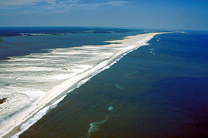
Barrier island
Barrier islands, a coastal landform and a type of barrier system, are relatively narrow strips of sand that parallel the mainland coast. They usually occur in chains, consisting of anything from a few islands to more than a dozen...
located off the eastern coast of Maryland
Maryland
Maryland is a U.S. state located in the Mid Atlantic region of the United States, bordering Virginia, West Virginia, and the District of Columbia to its south and west; Pennsylvania to its north; and Delaware to its east...
and Virginia
Virginia
The Commonwealth of Virginia , is a U.S. state on the Atlantic Coast of the Southern United States. Virginia is nicknamed the "Old Dominion" and sometimes the "Mother of Presidents" after the eight U.S. presidents born there...
. It is best known for its herds of feral horse
Feral horse
A feral horse is a free-roaming horse of domesticated ancestry. As such, a feral horse is not a wild animal in the sense of an animal without domesticated ancestors. However, some populations of feral horses are managed as wildlife, and these horses often are popularly called "wild" horses...
s, pristine beaches, and the Assateague Light
Assateague Light
Assateague Light is the lighthouse located on the southern end of Assateague Island off the coast of the Virginia Eastern Shore, USA.The lighthouse is located within the Chincoteague National Wildlife Refuge and can be accessed by road from Chincoteague Island over the Assateague...
house. The island also contains numerous marshes, bays and coves, including Toms Cove
Toms Cove
Toms Cove is an embayment on the southern end of Assateague Island in Virginia with the mouth near Chincoteague Inlet. A U.S. Coast Guard station was located there. Toms Cove also contains the Toms Cove Visitor Center run by the U.S. National Park Service....
. Bridge access for cars is possible from both Maryland and Virginia, though no road
Road
A road is a thoroughfare, route, or way on land between two places, which typically has been paved or otherwise improved to allow travel by some conveyance, including a horse, cart, or motor vehicle. Roads consist of one, or sometimes two, roadways each with one or more lanes and also any...
runs the full length of the island.
History
Like all barrier islands, Assateague has changed in form over the years. The structure of barrier islands determined by movement of sand in the littoral zone, the land-facing side of the island. At one time, the island was connected to the lowest point of Fenwick IslandFenwick Island, Delaware
As of the census of 2000, there were 342 people, 178 households, and 126 families residing in the town. The population density was 994.5 people per square mile . There were 666 housing units at an average density of 1,936.7 per square mile . The racial makeup of the town was 99.42% White, and 0.58%...
. However, in August 1933, a hurricane created an inlet
Inlet
An inlet is a narrow body of water between islands or leading inland from a larger body of water, often leading to an enclosed body of water, such as a sound, bay, lagoon or marsh. In sea coasts an inlet usually refers to the actual connection between a bay and the ocean and is often called an...
south of Ocean City, Maryland
Ocean City, Maryland
Ocean City, sometimes known as OC, or OCMD, is an Atlantic Ocean resort town in Worcester County, Maryland, United States. Ocean City is widely known in the Mid-Atlantic region of the United States and is a frequent destination for vacationers in that area...
. This inlet separated the two landforms. Normally, it would have silted back in due to the littoral drift that ran from north to south. However, after the storm, between 1933 and 1935 a permanent system of artificial jetties was built to preserve the inlet as a navigation channel. As a result, the island has drifted considerably westward, and the two landmasses are now over 1 km apart. While this process has benefitted Ocean City, creating wider beaches and better fishing access, it caused erosion problems on Assateague.
Between 1933 and the early 1960s, federal interest in creating a national seashore on the island alternated with periodic pushes for development. In 1950, a 15 mile section of the Maryland side of Assateague was platted for development, and a paved road, Baltimore Boulevard, was constructed to traverse the new development. A storm in 1962 destroyed or covered most of Baltimore Boulevard, and many of the structures on the island were destroyed. Although some private landowners on the island supported re-development, by this time the state of Maryland generally supported a national seashore and legislation was introduced in the United States Congress. After Congressional efforts did not produce final legislation in 1964, new legislation in 1965 was successful and Assateague Island National Seashore was formed.
Assateague Island National Seashore, Assateague State Park and the Chincoteague National Wildlife Refuge
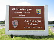
Assateague Island National Seashore
Assateague Island National Seashore is a unit of the National Park Service occupying much of Assateague Island along the Atlantic coast of Maryland and Virginia. It is a barrier island shaped by stormy seas and gentle winds. It lies adjacent to Assateague State Park and Chincoteague National...
and Assateague State Park
Assateague State Park
Assateague State Park is a public beach and state park of Maryland that lies at the northern end of Assateague Island. Reachable via Route 611, across Sinepuxent Bay via the Verrazano Bridge , Assateague State Park offers beaches and campsites to the public for a fee...
in Maryland, and the Chincoteague National Wildlife Refuge
Chincoteague National Wildlife Refuge
The Chincoteague National Wildlife Refuge is a wildlife preserve operated by the U.S. Fish & Wildlife Service. It is primarily located on the Virginia side of Assateague Island with portions located on the Maryland side of the island as well as Morris Island and Wildcat Marsh...
in Virginia. The Refuge was established in 1943 to provide habitat for migratory birds, primarily snow geese. Assateague Island National Seashore was established in 1965 to preserve the barrier island and surrounding waters, and provide recreational opportunities. The United Nations has designated Assateague as a World Biosphere Reserve. The U.S. Department of the Interior has designated it a National Natural Landmark.
Human use of the island
The National Park Service allows off-road vehicles with permits in certain areas. Car camping sites are available in both the National Seashore and Assateague State Park by reservation. Backcountry sites are also available from the National Seashore. There is no camping available from the Chincoteague National Wildlife Refuge. Pets are prohibited in all areas except certain parts of the National Seashore. Check with each agency to find out the specifics. Kayak touring is a popular way to see the wildlife, especially on the calmer bay side. The best times to backcountry camp are in the spring and fall. Summer months are known for heavy mosquito populations, particularly on the bay side.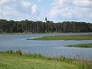
Wild horses of Assateague Island
The feral horseFeral horse
A feral horse is a free-roaming horse of domesticated ancestry. As such, a feral horse is not a wild animal in the sense of an animal without domesticated ancestors. However, some populations of feral horses are managed as wildlife, and these horses often are popularly called "wild" horses...
population of Assateague Island is alternately known as the Assateague horse in Maryland and the Chincoteague Pony in Virginia. This distinction, made both on per-breed and per-individual basis, is sometimes a matter of disagreement. The traditional definition of a horse or a pony is based on whether the animal in question falls over or under . The equines on the island tend to be under 14.2, but have a horse phenotype
Phenotype
A phenotype is an organism's observable characteristics or traits: such as its morphology, development, biochemical or physiological properties, behavior, and products of behavior...
. It is argued that their relatively small size is primarily due to environmental, rather than genetic conditions. The National Park Service provides information about these animals through brochures and the internet.
The Maryland and Virginia horses are kept apart by fencing at the border between the two states. Though commonly called "wild," these horses had domesticated ancestors, claimed in legend to be survivors of a Spanish galleon that shipwrecked along the coast, but possibly just local colonial horses allowed to run loose. When excess numbers are removed from the island and they are placed into human ownership, they adapt quickly to domestication. Made famous by Marguerite Henry
Marguerite Henry
Marguerite Henry was an American writer. Henry inspired children all over the world with her love of animals, especially horses. The author of fifty-nine books based on true stories of horses and other animals, her work has captivated entire generations of children and young adults and won...
in her children's book Misty of Chincoteague
Misty of Chincoteague
Misty of Chincoteague is a 1947 book by American author Marguerite Henry, inspired by a real Chincoteague Pony named Misty. Set on the coastal island of Chincoteague, Virginia, the book tells the story of the Beebe family and their efforts to raise a filly born to a wild horse. The book won the...
, the animals are popular tourist attractions and subjects for photography.
The Maryland horses are owned and managed by the National Park Service, who have carefully followed the population over generations. In Virginia, the Chincoteague ponies are owned by the Chincoteague Volunteer Fire Department
Chincoteague Fire Department
The Chincoteague Fire Department is a historic U.S. building located at 4026/4028 Main Street, Chincoteague Island, Virginia. This building was initially constructed in 1930 and expanded in 1957....
. Once a year in July, the local "salt water cowboys" round them up and sort a number of animals to be removed from the island, which are put up for auction on Pony Penning
Pony Penning
Pony Penning is an annual event held in Chincoteague, Virginia on the last consecutive Wednesday and Thursday in July. The Chincoteague Volunteer Fire Department conducts the event and it consists of a Wild Pony Swim on Wednesday and a Pony Auction on Thursday...
Day.
To keep their numbers under control on the Maryland side, a federal contraceptive program has been in place since 1994. In Virginia, the Pony Penning Days auction keeps the horse population at levels required by agreement with the Chincoteague National Wildlife Refuge.
Wildlife
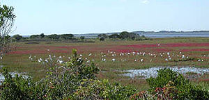
American Oystercatcher
The American Oystercatcher , occasionally called the American Pied Oystercatcher, is a member of family Haematopodidae. The bird is marked by its black and white body and a long, thick orange beak...
, Great Blue Heron
Great Blue Heron
The Great Blue Heron is a large wading bird in the heron family Ardeidae, common near the shores of open water and in wetlands over most of North and Central America as well as the West Indies and the Galápagos Islands. It is a rare vagrant to Europe, with records from Spain, the Azores and England...
, and Snowy Egret
Snowy Egret
The Snowy Egret is a small white heron. It is the American counterpart to the very similar Old World Little Egret, which has established a foothold in the Bahamas....
. There are over 320 species that are known to inhabit the island during some portion of the year. These include gulls, terns, and other shorebirds along with raptors, waterbirds, and waterfowl. The Piping Plover
Piping Plover
The Piping Plover is a small sand-colored, sparrow-sized shorebird that nests and feeds along coastal sand and gravel beaches in North America. The adult has yellow-orange legs, a black band across the forehead from eye to eye, and a black ring around the neck...
is a notable endangered species that nests on Assateague.