
Maryland Route 565
Encyclopedia
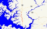
Maryland Route 565 is a collection of state highway
s in the U.S. state
of Maryland
. These three highways are sections of old alignment of U.S. Route 213, the predecessor route to US 50
, between Trappe
and Easton
. MD 565 runs from Trappe to US 50 south of Easton. MD 565A is a section of Washington Street in the southern part of Easton. MD 565B is an unsigned
spur of old alignment near the northern end of MD 565. MD 565 was assigned in the early 1940s when US 213 was moved to a new alignment between Trappe and Peach Blossom Creek in southern Talbot County
. MD 565A was designated in the late 1950s in the southern part of Easton and extended north of the downtown area in the mid 1960s. Portions of MD 565 were returned to municipal maintenance in Easton and Trappe in the mid 1980s and late 1990s.
auto dealership. Landing Neck Road continues east on the other side of the federal highway.
!Location
!Mile
!Destinations
!Notes
|-
|rowspan=1|Trappe
|0.00
|Main Street south / Maple Avenue
|Southern terminus of MD 565
|-
|rowspan=3|
|5.71
|MD 565B north
|MD 565 turns east at this intersection
|-
|rowspan=2|5.77
|
|rowspan=2|Northern terminus of MD 565
|-
|Landing Neck Road east
.
{| class=wikitable
!Mile
!Destinations
!Notes
|-
|0.00
|
|Southern terminus of MD 565A
|-
|0.58
|Washington Street north / Lee Terrace east
|Northern terminus of MD 565A
State highway
State highway, state road or state route can refer to one of three related concepts, two of them related to a state or provincial government in a country that is divided into states or provinces :#A...
s in the U.S. state
U.S. state
A U.S. state is any one of the 50 federated states of the United States of America that share sovereignty with the federal government. Because of this shared sovereignty, an American is a citizen both of the federal entity and of his or her state of domicile. Four states use the official title of...
of Maryland
Maryland
Maryland is a U.S. state located in the Mid Atlantic region of the United States, bordering Virginia, West Virginia, and the District of Columbia to its south and west; Pennsylvania to its north; and Delaware to its east...
. These three highways are sections of old alignment of U.S. Route 213, the predecessor route to US 50
U.S. Route 50 in Maryland
U.S. Route 50 is a major east–west route of the U.S. Highway system, stretching just over from Ocean City, Maryland on the Atlantic Ocean to West Sacramento, California. In the U.S. state of Maryland, US 50 exists in two sections. The longer of these serves as a major route connecting...
, between Trappe
Trappe, Maryland
Trappe is a town in Talbot County, Maryland, United States. The population was 1,146 at the 2000 census. The local telephone exchange is 476 and the area code is 410. The zipcode is 21673....
and Easton
Easton, Maryland
Easton, founded 1710, is a town within the Easton District of Talbot County, Maryland, United States. The population was 11,708 at the 2000 census, and 14,677 according to current July 2008 census estimates. It is the county seat of Talbot County. The primary ZIP Code is 21601, and the...
. MD 565 runs from Trappe to US 50 south of Easton. MD 565A is a section of Washington Street in the southern part of Easton. MD 565B is an unsigned
Unsigned highway
An unsigned highway is a highway that has been assigned a route number, but does not bear conventional road markings that would normally be used to identify the route with that number...
spur of old alignment near the northern end of MD 565. MD 565 was assigned in the early 1940s when US 213 was moved to a new alignment between Trappe and Peach Blossom Creek in southern Talbot County
Talbot County, Maryland
-2010:Whereas according to the 2010 U.S. Census Bureau:*81.4% White*12.8% Black*0.2% Native American*1.2% Asian*0.1% Native Hawaiian or Pacific Islander*1.6% Two or more races*2.7% Other races*5.5% Hispanic or Latino -2000:...
. MD 565A was designated in the late 1950s in the southern part of Easton and extended north of the downtown area in the mid 1960s. Portions of MD 565 were returned to municipal maintenance in Easton and Trappe in the mid 1980s and late 1990s.
MD 565
MD 565 is the designation for Main Street and Easton Trappe Road, a 5.77 miles (9.3 km) section of the old alignment of US 213 on the eastbound side of the federal highway between Trappe and Easton. The state highway begins at the intersection of Main Street and Maple Avenue in the town of Trappe. Main Street, which was once all MD 565, continues south 0.59 mile (0.9495106 km) as a municipal street to an intersection with US 50. The state highway heads north and its name changes to Easton Trappe Road on leaving the town after passing White Marsh Road. A short distance north of Llandaff Road near the hamlet of Llandaff a short distance south of Peach Blossom Creek, MD 565 turns sharply to the east and reaches its northern terminus at US 50 (Ocean Gateway). The old alignment of MD 565, an unnamed 0.14 mile (0.2253076 km) service road designated MD 565B, continues straight to serve as a driveway for a HondaHonda
is a Japanese public multinational corporation primarily known as a manufacturer of automobiles and motorcycles.Honda has been the world's largest motorcycle manufacturer since 1959, as well as the world's largest manufacturer of internal combustion engines measured by volume, producing more than...
auto dealership. Landing Neck Road continues east on the other side of the federal highway.
MD 565A
MD 565A is the designation for Washington Street, a 0.58 mile (0.9334172 km) section of the old alignment of US 213 on the eastbound side of the federal highway in Easton. The state highway begins at an intersection with MD 322 (Easton Parkway) a short distance north of MD 322's southern intersection with US 50. After crossing Paper Mill Pond, MD 565A reaches its northern terminus at Lee Terrace. Washington Street, which was once part of a longer MD 565A, continues north as a municipal street into downtown Easton.History
MD 565 was assigned to the old alignment of US 213 between Trappe and Peach Blossom Creek south of Easton by 1946 after US 213 was moved to a new alignment, presently used by US 50, in 1941. MD 565A was assigned to Washington Street south of MD 33 in 1958. MD 565A was extended north to Easton Parkway in 1965 when MD 33 was assigned to the northern part of Easton Parkway. The MD 565A designation was removed from Washington Street north of downtown Easton in 1985. The remainder of MD 565A north of Lee Terrace was transferred to the town of Easton in 1999. The portion of Main Street south of MD 565's present southern terminus was transferred to the town of Trappe in 1999.MD 565
{| class=wikitable!Location
!Mile
!Destinations
!Notes
|-
|rowspan=1|Trappe
Trappe, Maryland
Trappe is a town in Talbot County, Maryland, United States. The population was 1,146 at the 2000 census. The local telephone exchange is 476 and the area code is 410. The zipcode is 21673....
|0.00
|Main Street south / Maple Avenue
|Southern terminus of MD 565
|-
|rowspan=3|
|5.71
|MD 565B north
|MD 565 turns east at this intersection
|-
|rowspan=2|5.77
|
|rowspan=2|Northern terminus of MD 565
|-
|Landing Neck Road east
MD 565A
MD 565A is entirely within EastonEaston, Maryland
Easton, founded 1710, is a town within the Easton District of Talbot County, Maryland, United States. The population was 11,708 at the 2000 census, and 14,677 according to current July 2008 census estimates. It is the county seat of Talbot County. The primary ZIP Code is 21601, and the...
.
{| class=wikitable
!Mile
!Destinations
!Notes
|-
|0.00
|
|Southern terminus of MD 565A
|-
|0.58
|Washington Street north / Lee Terrace east
|Northern terminus of MD 565A