

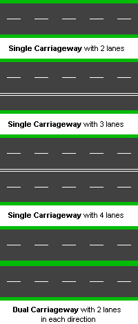
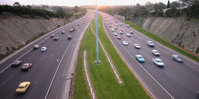
Dual carriageway
Encyclopedia

North American English
North American English is the variety of the English language of North America, including that of the United States and Canada. Because of their shared histories and the similarities between the pronunciation, vocabulary and accent of American English and Canadian English, the two spoken languages...
: divided highway) is a class of highway
Highway
A highway is any public road. In American English, the term is common and almost always designates major roads. In British English, the term designates any road open to the public. Any interconnected set of highways can be variously referred to as a "highway system", a "highway network", or a...
with two carriageways for traffic travelling in opposite directions separated by a central reservation
Central reservation
On divided roads, such as divided highways or freeways/motorways, the central reservation , median, parkway , median strip or central nature strip is the area which separates opposing lanes of traffic...
(North American English: median). Roads with two or more carriageways which are designed to higher standards with limited access
Limited-access road
A limited-access road known by various terms worldwide, including limited-access highway, dual-carriageway and expressway, is a highway or arterial road for high-speed traffic which has many or most characteristics of a controlled-access highway , including limited or no access to adjacent...
and grade separation are generally classed as motorways, freeways, etc., rather than dual carriageways. A road without a central reservation is a single carriageway
Single carriageway
A single carriageway is a road with 1, 2 or more lanes arranged within a single carriageway with no central reservation to separate opposing flows of traffic. Two-lane road or two-lane highway are single carriageway with one lane for each direction...
(North American English undivided highway) regardless of the number of lanes. Dual carriageways have improved road traffic safety over single carriageway
Single carriageway
A single carriageway is a road with 1, 2 or more lanes arranged within a single carriageway with no central reservation to separate opposing flows of traffic. Two-lane road or two-lane highway are single carriageway with one lane for each direction...
s and typically have higher speed limits as a result. In some places, express lanes and local/collector lanes are used within a local-express-lane system
Local-express lanes
A Local-express lane system is an arrangement of roadways within a major highway providing one of more roadways for express lanes with a limited number of entrances and exits and also separate roadways for local or collector lanes which provide access to all interchanges...
to provide more capacity and to smoothe traffic flows for longer-distance travel.
History
A very early (perhaps the first) example of a dual carriageway was the Via PortuensisVia Portuensis
Via Portuensis was an ancient Roman road, leading to the Portus constructed by Claudius on the right bank of the Tiber, at its mouth. It started from the Pons Aemilius, and the first part of its course is identical with that of the Via Campana...
, built in the first century by the Roman emperor Claudius
Claudius
Claudius , was Roman Emperor from 41 to 54. A member of the Julio-Claudian dynasty, he was the son of Drusus and Antonia Minor. He was born at Lugdunum in Gaul and was the first Roman Emperor to be born outside Italy...
between Rome
Rome
Rome is the capital of Italy and the country's largest and most populated city and comune, with over 2.7 million residents in . The city is located in the central-western portion of the Italian Peninsula, on the Tiber River within the Lazio region of Italy.Rome's history spans two and a half...
and its port Ostia at the mouth of the Tiber
Tiber
The Tiber is the third-longest river in Italy, rising in the Apennine Mountains in Emilia-Romagna and flowing through Umbria and Lazio to the Tyrrhenian Sea. It drains a basin estimated at...
.
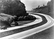
In 1907 the Long Island Motor Parkway
Long Island Motor Parkway
The Long Island Motor Parkway , also known as the Vanderbilt Parkway and Motor Parkway, was the first roadway designed for automobile use only. It was privately built by William Kissam Vanderbilt with overpasses and bridges to remove intersections...
opened and roughly 20% of it featured a semi-dual-carriageway design. The New York City
New York City
New York is the most populous city in the United States and the center of the New York Metropolitan Area, one of the most populous metropolitan areas in the world. New York exerts a significant impact upon global commerce, finance, media, art, fashion, research, technology, education, and...
Belt Parkway
Belt Parkway
The Belt System is a series of connected limited-access highways that form a belt-like circle around the New York City boroughs of Brooklyn and Queens. The system comprises four officially separate parkways; however, three of the four are signed as the Belt Parkway...
system, which was built between 1907 and 1934, also pioneered the same design. However the majority of it featured concrete or brick railings as lane dividers instead of grass medians.
In 1924 the first Italian autostrada
Autostrade of Italy
The Autostrada is the Italian national system of motorways. The total length of the system is about 6,400 km. In North and Central Italy this is mainly as tollways, with the biggest portion in concession to the Atlantia group which operates some 3,408 km...
was opened running 55 km (34.2 mi) from Milan to Varese. It featured a broad road bed and did not feature lane dividers except near cities and through the mountains.
The London end of the Great West Road became Britain's first dual carriageway when it was opened in 1925 by King George V.
In 1927 the Rome bypass was opened. It ran 92 km (57.2 mi) bypassing Rome to the east. Almost the entire length featured a dual-carriageway design. In the early 1930s it was extended southward all the way to Naples
Naples
Naples is a city in Southern Italy, situated on the country's west coast by the Gulf of Naples. Lying between two notable volcanic regions, Mount Vesuvius and the Phlegraean Fields, it is the capital of the region of Campania and of the province of Naples...
and northward to Florence. Most of the original routing was destroyed by the Allies in the World War II
World War II
World War II, or the Second World War , was a global conflict lasting from 1939 to 1945, involving most of the world's nations—including all of the great powers—eventually forming two opposing military alliances: the Allies and the Axis...
.
By 1930 several US and European cities had built dual-carriageway highways, mostly to control traffic jams and/or to provide bypass routes for traffic.
In 1932 the first German autobahn opened between Cologne and Bonn. It ran 21 km (13 mi) and became a precedent for future highways. Although it, like the first autostrada, did not feature a dual-carriageway design, it inspired the mass construction of future high-speed roadways.
During the 1930s, Germany, Italy, and the Soviet Union began construction of a network of dual carriageway expressways. By 1942, Germany had over 3200 km (1,988.4 mi) of dual carriageway roads, Italy had nearly 1300 km (807.8 mi), and the Soviet Union had 400 km (248.5 mi).
What may be the world's first long-distance intercity dual carriageway/freeway is the Queen Elizabeth Way
Queen Elizabeth Way
The Queen Elizabeth Way, commonly abbreviated as the QEW, is a 400-Series highway in the Canadian province of Ontario. The freeway links Buffalo, New York and the Niagara Peninsula with Toronto. It begins at the Peace Bridge in Fort Erie and travels around the western shore of Lake Ontario, ending...
in Southern Ontario
Southern Ontario
Southern Ontario is a region of the province of Ontario, Canada that lies south of the French River and Algonquin Park. Depending on the inclusion of the Parry Sound and Muskoka districts, its surface area would cover between 14 to 15% of the province. It is the southernmost region of...
in Canada
Canada
Canada is a North American country consisting of ten provinces and three territories. Located in the northern part of the continent, it extends from the Atlantic Ocean in the east to the Pacific Ocean in the west, and northward into the Arctic Ocean...
, initially linking the large cities of Toronto
Toronto
Toronto is the provincial capital of Ontario and the largest city in Canada. It is located in Southern Ontario on the northwestern shore of Lake Ontario. A relatively modern city, Toronto's history dates back to the late-18th century, when its land was first purchased by the British monarchy from...
and Hamilton
Hamilton, Ontario
Hamilton is a port city in the Canadian province of Ontario. Conceived by George Hamilton when he purchased the Durand farm shortly after the War of 1812, Hamilton has become the centre of a densely populated and industrialized region at the west end of Lake Ontario known as the Golden Horseshoe...
together by 1939, with construction on this stretch of the present-day Queen Elizabeth Way beginning in 1936 as "Middle Road".
Opened to traffic in 1940, the 160 miles (257.5 km) long Pennsylvania Turnpike
Pennsylvania Turnpike
The Pennsylvania Turnpike is a toll highway system operated by the Pennsylvania Turnpike Commission in the Commonwealth of Pennsylvania, United States. The three sections of the turnpike system total . The main section extends from Ohio to New Jersey and is long...
was the first rural dual carriageway built in the United States. By 1955 several states had built dual carriageway freeways and turnpikes and in 1957 the Interstate Highway System
Interstate Highway System
The Dwight D. Eisenhower National System of Interstate and Defense Highways, , is a network of limited-access roads including freeways, highways, and expressways forming part of the National Highway System of the United States of America...
began. Completed in 1994, the major highway system links all the major cities of the United States.
United Kingdom
In the UKUnited Kingdom
The United Kingdom of Great Britain and Northern IrelandIn the United Kingdom and Dependencies, other languages have been officially recognised as legitimate autochthonous languages under the European Charter for Regional or Minority Languages...
, although the term dual carriageway applies to any road with physically separated lanes, it is frequently used as a descriptive term for major route
Highway
A highway is any public road. In American English, the term is common and almost always designates major roads. In British English, the term designates any road open to the public. Any interconnected set of highways can be variously referred to as a "highway system", a "highway network", or a...
s built in this style. Such major dual carriageways usually have two lanes of traffic in each direction, with the lane nearest the centre being reserved for overtaking. Occasionally dual carriageways have only one lane in each direction, or more than two lanes each way (usually to permit easier overtaking of slower uphill traffic). Different speed limits apply on dual carriageway sections from those that apply on single carriageway
Single carriageway
A single carriageway is a road with 1, 2 or more lanes arranged within a single carriageway with no central reservation to separate opposing flows of traffic. Two-lane road or two-lane highway are single carriageway with one lane for each direction...
sections of the same class of road, except in cities and built-up areas where the dual carriageway is more of a safety measure, often intended to prevent pedestrian
Pedestrian
A pedestrian is a person traveling on foot, whether walking or running. In some communities, those traveling using roller skates or skateboards are also considered to be pedestrians. In modern times, the term mostly refers to someone walking on a road or footpath, but this was not the case...
s from crossing a busy road.
Turning right (that is, across the line of traffic heading in the opposite direction) is usually permitted only at specific locations. Often the driver will be required to turn left (away from the dual carriageway) in order to loop around to an access road that permits crossing the major road. Roundabout
Roundabout
A roundabout is the name for a road junction in which traffic moves in one direction around a central island. The word dates from the early 20th century. Roundabouts are common in many countries around the world...
s on dual carriageways are relatively common, especially in cities or where the cost of a grade-separated junction would be prohibitive. Where space is even more limited, intersections may be controlled by traffic lights. Smaller residential roads adjoining urban dual carriageways may be blocked off at one end in an attempt to limit the number of junctions on a dual carriageway, often other roads may pass over or under the dual-carriageway without an intersection.
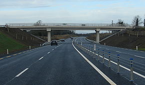
A dual carriageway with grade-separated junctions and which meets other requirements may be upgraded to motorway standard, denoted as an (M) added after the road number (e.g. "A1(M)" or "A38(M)"). Unlike in the Republic of Ireland
Republic of Ireland
Ireland , described as the Republic of Ireland , is a sovereign state in Europe occupying approximately five-sixths of the island of the same name. Its capital is Dublin. Ireland, which had a population of 4.58 million in 2011, is a constitutional republic governed as a parliamentary democracy,...
, there is no official terminology for 'high-quality dual carriageways'. Many roads such as the A1, the A14, the A19
A19 road
The A19 is a major road in England running approximately parallel to and east of the A1 road, although the two roads meet at the northern end of the A19, the two roads originally met at the southern end of the A19 in Doncaster but the old route of the A1 was changed to the A638. From Sunderland...
and the A42
A42 road
The A42 is a major trunk road in the East Midlands region of the United Kingdom. It links junction 23A of the M1 motorway to junction 11 of the M42 motorway. The A42 is in effect a continuation of the M42, and its junctions are numbered accordingly....
are built to a high quality, with grade-separated junctions, full barriers at roadside and central reservations and, in some cases, three lanes of traffic. They may still fall short of motorway standard in terms of the height of overpasses or the quality of intersecting junctions.
Speed limits
The national speed limit applies on dual carriageways (unless it is in a 'built-up area', or a lower limit is posted), which is as follows:| Type of vehicle | Speed limit |
|---|---|
| Car Automobile An automobile, autocar, motor car or car is a wheeled motor vehicle used for transporting passengers, which also carries its own engine or motor... , motorcycle Motorcycle A motorcycle is a single-track, two-wheeled motor vehicle. Motorcycles vary considerably depending on the task for which they are designed, such as long distance travel, navigating congested urban traffic, cruising, sport and racing, or off-road conditions.Motorcycles are one of the most... or a car-based van Van A van is a kind of vehicle used for transporting goods or groups of people.In British English usage, it can be either specially designed or based on a saloon or sedan car, the latter type often including derivatives with open backs... up to 2 metric tonnes |
70 mi/h |
| Car with caravan Travel trailer A travel trailer or caravan is towed behind a road vehicle to provide a place to sleep which is more comfortable and protected than a tent . It provides the means for people to have their own home on a journey or a vacation, without relying on a motel or hotel, and enables them to stay in places... or trailer |
60 mi/h |
| Bus Bus A bus is a road vehicle designed to carry passengers. Buses can have a capacity as high as 300 passengers. The most common type of bus is the single-decker bus, with larger loads carried by double-decker buses and articulated buses, and smaller loads carried by midibuses and minibuses; coaches are... or coach Coach (vehicle) A coach is a large motor vehicle, a type of bus, used for conveying passengers on excursions and on longer distance express coach scheduled transport between cities - or even between countries... up to 12 m long |
60 mi/h |
| Goods vehicle up to 7.5 t | 60 mi/h |
| Goods vehicle over 7.5 t | 50 mi/h |
A dual carriageway in a built up area will have a statutory speed limit of 30 mi/h unless otherwise sign-posted. It is common for such urban dual carriageways to have an increased speed limit of 40 mi/h. A built up road is indicated by the presence of street lights, on lit dual carriageways that are not considered to be in a built-up area, the speed limit will be clarified with intermittent signs.
Ireland
Republic of Ireland
Ireland , described as the Republic of Ireland , is a sovereign state in Europe occupying approximately five-sixths of the island of the same name. Its capital is Dublin. Ireland, which had a population of 4.58 million in 2011, is a constitutional republic governed as a parliamentary democracy,...
the term dual carriageway technically applies to any road with physically separated lanes, it is usually used only to refer to those route sections that do not have a motorway designation. Most often it is national roads (roads with a route number prefix of N; e.g. N8) that are built as or upgraded to dual carriageway. A number of non-national roads (for example, regional road
Regional road
A regional road in Ireland is a class of road not forming a major route , but nevertheless forming a link in the national route network. There are over 11,600 kilometres of regional roads. Regional roads are numbered with three digit route numbers, prefixed by "R" A regional road in Ireland is a...
s) are dual carriageway, for example in urban areas near or in cities, or where the road was formerly part of a national route.
Dual carriageways of this class differ from motorways in a number of ways. The hard shoulder is demarcated with a dashed yellow line (as opposed to an unbroken yellow line on motorways). The standard speed limit of 100 km/h (62 mph) for national routes usually applies (by default the limit is 80 km/h (50 mph) for non-national roads, even if dual carriageway). Local authorities have the power to apply a limit of up to 120 km/h (75 mph) as used on most motorways (The High Quality Dual Carriageway section of the N1 between the end of the M1 and the border with Northern Ireland
Northern Ireland
Northern Ireland is one of the four countries of the United Kingdom. Situated in the north-east of the island of Ireland, it shares a border with the Republic of Ireland to the south and west...
and the N25/N22 Ballincollig Bypass in Cork are the only route sections with such special limits). Traffic lights and junctions are permitted at grade on dual carriageways. For older sections of dual carriageway, this has resulted in fewer flyover junctions. Newer dual carriageway sections are usually near motorway standard, with grade-separated junctions, but may not be designated as motorways due to the need to preserve access to adjoining property or to the absence of a non-motorway alternative route. Also, dual carriageways that are not motorway classified do not need to be equipped with emergency phones.
Motorway restrictions only apply to motorway sections, rather than all dual carriageway sections of national roads (these are signposted with the N prefix on the route number, rather than M). Some national secondary road
National secondary road
A national secondary road is a category of road in Ireland. These roads form an important part of the national route network, but are secondary to the main arterial routes which are classified as national primary roads. National secondary roads are designated with route numbers higher than those...
s, and regional roads in particular often have houses, schools and other developments fronting on to them. Less important national primary road
National primary road
A national primary road is a road classification in the Republic of Ireland. National primary roads form the major routes between the major urban centres. There are over 2,700km of national primary roads. This category of road has the prefix "N" followed by one or two digits...
s, and older sections not yet upgraded may also feature such developments built before the introduction the Irish Planning system in 1964. Today Irish planning policy prohibits such development on National Primary or National Secondary roads where the speed limit exceeds 60 km/h (37 mph). This policy results from concerns expressed by the National Roads Authority. However, a local authority is not obliged to implement this policy and can disregard this policy at it own discretion. This would usually only occur in exceptional circumstances or where planners are over ruled by elected councillors using section 140 of the Local Government Act 2001. Accordingly, hard shoulders are included wherever feasible to provide for the resulting pedestrian and cyclist traffic, and are present on much of the national route network. These hard shoulders may also be used as running lanes by motorised traffic under certain conditions.
Until 2004/2005, many motorways and dual carriageways in Ireland did not have crash barriers in the central reservation, the policy being to use a wider median instead. Crash barriers are now mandatory for such routes, and wire cabling or full crash barriers (depending on whether or not the route is a motorway, and median width) have been fitted to existing routes.
three major types of dual carriageway are being built on national road schemes in the Republic of Ireland:
- High Quality Dual Carriageways (HQDC) - these are being built mainly on the major inter-urban routes, to full motorway standard but without motorway regulations. The Roads Act 2007 allows for these roads to be redesignated as motorways by ministerial order. Many of the sections of HQDC on the major inter-urban routes have been redesignated as motorways and full motorway regulations will apply when the redesignations come into effect.
- Standard dual carriageway of the traditional type is mainly planned for schemes on the N11 road, the N18 road and the N25 roadN25 roadThe N25 road is a national primary road in Ireland, forming the route from Cork to Rosslare Europort via Waterford City. The road is part of the E30 European route and a short section is also part of the E01 European route...
. Plans for this type of dual carriageway on the N20 road have been superseded by newer plans to build a motorway, the M20, to replace most of this route. Traditionally this type of dual-carriageway had a mixture of at grade junctions (including roundabouts), grade separated junctions, and median crossings. Nowadays they are similar to HQDCs, but minor at grade exits - generally left turn only - are allowed and the design speed (by Irish standards) is only 100 km/h. Median crossings and roundabouts are no longer generally found on these schemes. An example of a standard dual carriageway scheme, opened in 2006, is the EnnisEnnisEnnis is the county town of Clare in Ireland. Situated on the River Fergus, it lies north of Limerick and south of Galway. Its name is a shortening of the original ....
bypass although this road has grade separated junctions and no median crossings. This route has now been upgraded to motorway status. - 2+2 road2+2 roadA 2+2 road is a specific type of dual-carriageway being built in Ireland and Sweden, consisting of two lanes in each direction separated with a steel cable barrier. They do not have hard shoulders. Junctions are at-grade roundabouts and minor roads cross under or over the mainline without...
s - officially these roads are designated as Type 2 dual carriageways by the National Roads AuthorityNational Roads AuthorityThe National Roads Authority is a state body in the Republic of Ireland, responsible for the national road network. The NRA was established as part of the Roads Act 1993 and commenced operations on 23 December 1993 in accordance with S.I. 407 of 1993.County councils remain responsible for local...
(NRA). They will be created by widening existing roads or building new roads, and will have two lanes in each direction with a steel cable barrierCable barrierCable barrier, sometimes referred to as guard cable, is a type of roadside or median barrier. It consists of steel wire ropes mounted on weak posts. As is the case with any roadside barrier, its primary purpose is to prevent a vehicle from leaving the traveled way and striking a fixed object or...
in the middle but no hard shoulder. Most junctions will be at grade. With the exception of the restricted median width and the lack of lay-bys, this type of dual carriageway is similar to many dual carriageways found in the UK. The first 2+2 scheme (and the only example as of 2008), the N4 DromodDromodDromod is a village in County Leitrim, Ireland. Dromod is a noted fishing village on Loughs Bofin and Boderg, which are threaded by the River Shannon....
RooskyRooskyRoosky or Rooskey is a village on the River Shannon in County Roscommon, Ireland in the northern midlands of Ireland, near the point where counties Leitrim, Longford, and Roscommon meet. The N4 road from Dublin to Sligo passes by the Leitrim side of the village.- History :Roosky has had a...
bypass, opened on 7 December 2007. - 2+1 road2+1 road2+1 road is a specific category of three-lane road, consisting of two lanes in one direction and one lane in the other, alternating every few kilometres, and separated usually with a steel cable barrier. Traditional roads of at least width can be converted to 2+1 roads and reach near-motorway...
s - officially these roads are designated as Type 3 dual carriageways by the NRA. They have two lanes in one direction and one lane in the other, alternating every few kilometres, and usually separated with a steel cable barrier. Sections of 2+1 road have been built on the N20 and the N2. In July 2007, the NRA announced that it would no longer build 2+1 roads and 2+2 roads will be built instead.
Germany
In Germany the term "Schnellstraße" (expressway) refers to streets that allow for higher speed traffic than is common on other streets which in turn requires them to have a dual carriageway in most cases. A special exception is the 2+1 road2+1 road
2+1 road is a specific category of three-lane road, consisting of two lanes in one direction and one lane in the other, alternating every few kilometres, and separated usually with a steel cable barrier. Traditional roads of at least width can be converted to 2+1 roads and reach near-motorway...
system in some rural areas that are also referred to as expressways (three lanes on a single carriageway where bypassing on the lane of the opposite direction is prohibited so that speed restriction is not required to increase safety - they are generally built to a 100 or 120 km/h traffic standard). This is based on the definition of expressways as having an increased amount of grade-separated sections. Technically a dual carriageway with central reservation is the legal foundation that no blank speed limit exists - comparable to the German Autobahn - but expressways are factually always given speed limit signs.
Expressways however can be upgraded to motorway standard which is colloquially referred to as "Gelbe Autobahn" (yellow motorway) because they have the same technical standard of the German autobahn but they use black on yellow signs instead of the white on blue signs on the Autobahn motorway network. These are generally high speed arterial roads of larger cities and important streets inside a federal state that do not connect major cities so that they do not fall under the federal budgeting program for the Autobahn network. The federal road Bundesstraße 27 is an example where about half of its length is upgraded to a high speed motorway standard. Some of these non-Autobahn motorways do not have an actual speed limit (design speed 130 km/h).
Exit signs.
The increasing importance of motorways outside of the Autobahn network is subject to upcoming legislation which does not exist so far in Germany where technically these are just rural roads that refer to the ministerial sign code for high speed dual carriageways. At the moment some (blue) motorways have been taken out of the Autobahn network program while still using the blue signs and on the other hand some former non-Autobahn (yellow) motorways have been added to Autobahn budgeting but the signs were not changed either. Motorways that are neither in the Autobahn network nor in the Bundesstraße network are given black on white signs following the same sign code for high speed dual carriageways - this is mostly seen with urban trunk roads.
Italy
In Italy, a dual carriageway is often called superstrada (meaning expressway), but this name is unofficial.Italian Highway Code (Codice della strada) divides dual carriageways into three different classifications:
- strada extraurbana principale (meaning main highway) or type-B road: a road with separate carriageways, at least two lanes for each direction, paved shoulder on the right and no cross-traffic. This type of road is quite similar to an autostrada or type-A road (Italian official name for motorways or freeways), but its building standards are lower. Access limitations and drive behaviour on type-B roads are exactly the same of the motorways (no pedestrians, bicycles and other low vehicles), as well as the signage (except for the background color, that is blue instead of green). Speed limit on type-B roads is up to 110 kilometers per hour. Type-B roads are always toll-free.
- strada extraurbana secondaria (meaning less importance road) or type-C road. This category contains all the roads in non-urban context that are neither autostrada (type A) nor strada extraurbana principale (type B). This means that a dual carriageway that may not be classified as type-B road, since it does not meet such quality standards, belongs to this category. For type-C roads, there aren't neither special signage nor access restrictions, unless a specific sign is placed. Speed limit is 90 kilometers per hour, on both single and dual carriageways.
- strada urbana di scorrimento (meaning urban expressway) or type-D road: a road in urban context, with separate carriageways, and at least two lanes for each direction. At-level junctions with smaller roads, regulated by traffic lights, are allowed as well as roundaboutRoundaboutA roundabout is the name for a road junction in which traffic moves in one direction around a central island. The word dates from the early 20th century. Roundabouts are common in many countries around the world...
s. Unless a prohibition sign is placed, there are not access restrictions. Speed limit on this type of road is up to 70 kilometers per hour.
Italian type-B and type-C roads do not follow a specific numbering criterion. They may be numbered as state roads (SS), regional roads (SR), provincial roads (SP) or municipal roads (SC).
Croatia
Dual carriageways or expressways in CroatiaCroatia
Croatia , officially the Republic of Croatia , is a unitary democratic parliamentary republic in Europe at the crossroads of the Mitteleuropa, the Balkans, and the Mediterranean. Its capital and largest city is Zagreb. The country is divided into 20 counties and the city of Zagreb. Croatia covers ...
are non-tolled roads with 2 or more lanes in each direction, but without emergency lanes. The main highways/motorways in Croatia
Highways in Croatia
Highways in Croatia are the main transport network in Croatia.The Croatian classification includes several classes of highways:* The main motorways are named A accompanied by one or two digits...
are also dual carriageways, but they have emergency lanes and tolls.
Many bypasses and beltways of smaller cities in Croatia have been recently constructed or planned as dual carriageways. All dual carriageways in Croatia house a central median, usually fitted with guardrails.
The most heavily used dual carriageway in Croatia is the B28 expressway
B28 (Croatia)
D28 is a state road in the central Croatia connecting the D5 in Veliki Zdenci to the A4 motorway in Sveta Helena interchange near Vrbovec. The road is long....
, connecting capital Zagreb
Zagreb
Zagreb is the capital and the largest city of the Republic of Croatia. It is in the northwest of the country, along the Sava river, at the southern slopes of the Medvednica mountain. Zagreb lies at an elevation of approximately above sea level. According to the last official census, Zagreb's city...
to a satellite town
Satellite town
A satellite town or satellite city is a concept in urban planning that refers essentially to smaller metropolitan areas which are located somewhat near to, but are mostly independent of, larger metropolitan areas.-Characteristics:...
, Vrbovec
Vrbovec
Vrbovec is city in Zagreb county, Croatia, lying to the northeast of the capital Zagreb.-Geography:The town of Vrbovec lies to the north-east of Zagreb, either along the highway A4 , and then B28 expressway Vrbovec is city in Zagreb county, Croatia, lying to the northeast of the capital...
. The D28 is currently finished up to the Gradec interchange. It is undergoing extensions which will increase the traffic traversing it.
United States

Jersey barrier
A Jersey barrier or Jersey wall is a modular concrete barrier employed to separate lanes of traffic. It is designed to both minimize vehicle damage in cases of incidental contact while still preventing crossover in the case of head-on accidents....
separating the traffic directions. With few exceptions, all roads in the federally funded Interstate Highway System
Interstate Highway System
The Dwight D. Eisenhower National System of Interstate and Defense Highways, , is a network of limited-access roads including freeways, highways, and expressways forming part of the National Highway System of the United States of America...
are fully controlled access divided highways known as freeways. A broader definition, expressways
Limited-access road
A limited-access road known by various terms worldwide, including limited-access highway, dual-carriageway and expressway, is a highway or arterial road for high-speed traffic which has many or most characteristics of a controlled-access highway , including limited or no access to adjacent...
, includes both freeways and partial limited-access divided highways, and "expressway" is often used specifically to refer to the latter. United States Numbered Highways
United States Numbered Highways
The system of United States Numbered Highways is an integrated system of roads and highways in the United States numbered within a nationwide grid...
, state highways and other locally maintained highways may also be divided. Speed limits
Speed limits in the United States
Speed limits in the United States are set by each state or territory. Speed limits in the United States vary according to many factors, including each state or territory's laws, the type of road, land use, and more. Increments of five miles per hour are used. Additionally, these limits sometimes...
on rural divided highway
Divided Highway
Divided Highway is a compilation album by American rock band The Doobie Brothers, released in 2003. . All tracks are taken from the albums Cycles and Brotherhood .-Track listing:...
s range from 65–75 mph (29.1–33.5 ), with some portions as high as 80 miles per hour (35.8 m/s). Urban divided highways which are at grade and typically have much lower speed limits are sometimes called boulevards.
In keeping with the U.S. Department of Transportation's of Uniform Traffic Controls and Devices (MUTCD), since the early 1970s all divided highways are striped by color to show the direction of traffic flow. Two-way undivided roads have an amber center line, with a broken line indicating passing zones and a solid line indicating no passing zones and solid white baseline shoulder stripes. On undivided roads with more than one lane in each direction, the center is normally marked with a double solid line. The double solid stripe denotes that it is illegal to pass
Overtaking
Overtaking or passing is the act of one vehicle going past another slower moving vehicle, travelling in the same direction, on a road. The lane used for overtaking another vehicle is almost always a lane further from the road shoulder — that is, to the left in places that drive on the right,...
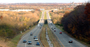
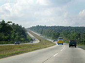
on the other side of the center line. Multilane one-way carriageways use broken white lines between lanes; the median-side baseline is solid amber, and the right sideline is solid white. Frequently in the U.S. the two carriageways are separated by some distance (wide medians with small forests or even hills in them), but drivers can always tell whether the roadway is two-way or one-way—and, if one-way, the direction in which the traffic flows—by looking at the striping coloration. For an example, see inset showing US Route 52 near Lafayette, Indiana
Lafayette, Indiana
Lafayette is a city in and the county seat of Tippecanoe County, Indiana, United States, northwest of Indianapolis. As of the 2010 census, the city had a total population of 67,140. West Lafayette, on the other side of the Wabash River, is home to Purdue University, which has a large impact on...
.
Canada
In CanadaCanada
Canada is a North American country consisting of ten provinces and three territories. Located in the northern part of the continent, it extends from the Atlantic Ocean in the east to the Pacific Ocean in the west, and northward into the Arctic Ocean...
, "divided highway" is used for this type of road, and the segment between the roadways is referred to as a "median". More informally, a divided highway may be referred to as "twinned". This stems from the practice of "twinning" an existing two-lane highway (usually controlled-access) and converting it into a divided highway. On some portions of Ontario
Ontario
Ontario is a province of Canada, located in east-central Canada. It is Canada's most populous province and second largest in total area. It is home to the nation's most populous city, Toronto, and the nation's capital, Ottawa....
's 400-series highway
400-series highways (Ontario)
The 400-series highways are a network of controlled-access highways throughout the southern portion of the Canadian province of Ontario, forming a special subset of the provincial highway system. They are analogous to the Interstate Highway System in the United States or the British Motorway...
network, the median may be either steel guardrail
Guardrail
Guardrail can refer to*Guard rails installed on road sides for automobile safety*RC-12 Guardrail, a U.S. Army intelligence-gathering aircraft based on the C-12 Huron*Roof edge protection, rails installed on roofs to protect construction and roofing workers...
or an Ontario tall-wall
Jersey barrier
A Jersey barrier or Jersey wall is a modular concrete barrier employed to separate lanes of traffic. It is designed to both minimize vehicle damage in cases of incidental contact while still preventing crossover in the case of head-on accidents....
barrier rather than an unpaved strip.
Like the US, there are two types of divided highways, fully controlled access divided routes known as freeways, while expressways
Limited-access road
A limited-access road known by various terms worldwide, including limited-access highway, dual-carriageway and expressway, is a highway or arterial road for high-speed traffic which has many or most characteristics of a controlled-access highway , including limited or no access to adjacent...
may include both freeways and partial limited-access divided highways. Canadians often use "highway" to refer to freeways. Partial limited-access divided highways such as the Hanlon Parkway
Hanlon Parkway
The Hanlon Parkway is a high-capacity at-grade suburban expressway in the city of Guelph, Ontario, Canada, which connects it with Highway 401. It runs in a general north-south direction in the city's west end. It is signed as Highway 6 for its whole length; from Wellington Street to Woodlawn Road,...
and Black Creek Drive
Black Creek Drive
Black Creek Drive is a north-south arterial road in Toronto, Ontario that extends from Highway 400 at Jane Street, near Ontario Highway 401 to Weston Road in the south. Originally intended to be a freeway extension of Ontario Highway 400, it was built instead as an arterial road after public...
have at-grade intersections and private entrances but have sufficient right-of-way to convert them to full freeways if traffic warrants. There are also RIRO expressway
Right-in/right-out
Right-in/right-out and left-in/left-out refer to a type of road intersection where turning movements of vehicles are restricted. A RIRO permits only right turns and a LILO permits only left turns. RIRO is usual where vehicles drive on the right, and LILO is usual where vehicles drive on the left...
s, such as Highway 11
Highway 11 (Ontario)
King's Highway 11 is a provincially maintained highway in the Canadian province of Ontario. At , it is the second longest highway in the province after Highway 17. Highway 11 begins at Highway 400 in Barrie, and arches through northern Ontario, around Lake Superior, to the Ontario–Minnesota border...
and a portion of Highway 35
Highway 35 (Ontario)
King's Highway 35, also known as Highway 35, is a provincial highway in the Canadian province of Ontario, linking Highway 401 with Peterborough, Kawartha Lakes, and Algonquin Park. The highway travels from west of Newcastle, through Lindsay and the Kawarthas and into Haliburton before terminating...
, which are not full freeways since they allow access to existing properties, but traffic speeds are faster than regular roads due to a median barrier preventing left turns (motorists have to use a "turnabout" overpass to access exits on the opposing direction).
Junctions may be at-grade or grade-separated
Grade separation
Grade separation is the method of aligning a junction of two or more transport axes at different heights so that they will not disrupt the traffic flow on other transit routes when they cross each other. The composition of such transport axes does not have to be uniform; it can consist of a...
, and there may be gaps in the median strip to allow turning and crossing. Divided highways are seldom equipped with traffic circle
Traffic circle
A traffic circle or rotary is a type of circular intersection in which traffic must travel in one direction around a central island. In some countries, traffic entering the circle has the right-of-way and drivers in the circle must yield. In many other countries, traffic entering the circle must...
s, roundabouts, or rotaries.
Australia
Hume Highway
The Hume Highway/Hume Freeway is one of Australia's major inter-city highways, running for 880 km between Sydney and Melbourne. It is part of the Auslink National Network and is a vital link for road freight to transport goods to and from the two cities as well as serving Albury-Wodonga and...
and the Pacific Highway (Australia)
Pacific Highway (Australia)
The Pacific Highway is a major transport route along part of the east coast of Australia and is part of Australia's national route 1.It is 960 km long and links Sydney, the capital of New South Wales, to Brisbane, the capital of Queensland, along the coast, via Gosford, Newcastle, Taree, Port...
; the Hume Highway by 2012, will be 100% dual carriageway and the Pacific Highway by 2016 will also be 100% dual carriageway. Today, 90% of the Hume Highway is dual carriageway and only 40% or 280 km (174 mi) of the Pacific Highway is dual carriageway, plus 10% of the Pacific Highway or 78 kilometres (48.5 mi) is under construction. The Federal Highway
Federal Highway
Federal Highways and Federal Routes can be found in:*Australia, National Highway 23 a short highway in New South Wales and the Australian Capital Territory is called the Federal Highway ....
between the Hume Highway
Hume Highway
The Hume Highway/Hume Freeway is one of Australia's major inter-city highways, running for 880 km between Sydney and Melbourne. It is part of the Auslink National Network and is a vital link for road freight to transport goods to and from the two cities as well as serving Albury-Wodonga and...
at Goulburn and Canberra
Canberra
Canberra is the capital city of Australia. With a population of over 345,000, it is Australia's largest inland city and the eighth-largest city overall. The city is located at the northern end of the Australian Capital Territory , south-west of Sydney, and north-east of Melbourne...
is 100% dual carriageway, completed before the 2000 Summer Olympic Games. Some parts of the Princes Highway
Princes Highway
The Princes Highway extends from Sydney to Port Augusta via the coast through the states of New South Wales, Victoria and South Australia, a distance of 1941 km or 1898 km via the former alignments of the highway ....
, Great Western Highway
Great Western Highway
The Great Western Highway is a highway in New South Wales, Australia. It runs 210 km from Sydney to Bathurst.Starting as Broadway at the intersection of City Road near the fringe of the Sydney CBD, and becoming Parramatta Road to Parramatta itself, the Great Western Highway heads due west from...
(A32) and the Barton Highway
Barton Highway
The Barton Highway is a short highway in New South Wales and the Australian Capital Territory, Australia.The Barton Highway connects Canberra to the Hume Highway at Yass, and it is part of the route from Melbourne to Canberra....
are also dual carriageway. Most non-urban dual carriageway highways/freeways are speed limited to 110 km/h (100 km/h for heavy vehicles), except for a short section in the Australian Capital Territory
Australian Capital Territory
The Australian Capital Territory, often abbreviated ACT, is the capital territory of the Commonwealth of Australia and is the smallest self-governing internal territory...
on the Federal Highway
Federal Highway
Federal Highways and Federal Routes can be found in:*Australia, National Highway 23 a short highway in New South Wales and the Australian Capital Territory is called the Federal Highway ....
which is state limited to 100 km/h. The Warrego Highway between Brisbane and Toowoomba in Queensland is also dual carriageway with a maximum speed limit of 100km/h.
In Australia there is much confusion among the local population between a freeway and a dual carriageway, particularly those roads found in rural areas. While to be labelled a freeway, a road in Australia must have graded junctions, a physical barrier to separate the carriageways is not required. Speed limits do not change when road grades change from freeway to dual carriageway and vice versa. Stopping and U-turn prohibitions on Australian freeways are routinely ignored and rarely enforced. The Hume Freeway in Victoria, is actually a dual-carriageway grade road for much of its length with many ungraded junctions. Despite this, it has officially been called the "Hume Freeway" and given a route marking of M31. An M marking is traditionally used for Motorway or Freeway lengths of roads in international jurisdictions that adopt the same MABC route labelling system as Victoria.
Sources:
- AusLinkAusLinkAusLink was an Australian Government land transport funding program, established in June 2004 and administered by the Department of Transport and Regional Services. In 2009 it was replaced with the Nation Building Program under the Nation Building Program Act 2009...
- Hume HighwayHume HighwayThe Hume Highway/Hume Freeway is one of Australia's major inter-city highways, running for 880 km between Sydney and Melbourne. It is part of the Auslink National Network and is a vital link for road freight to transport goods to and from the two cities as well as serving Albury-Wodonga and...
- Pacific Highway (Australia)Pacific Highway (Australia)The Pacific Highway is a major transport route along part of the east coast of Australia and is part of Australia's national route 1.It is 960 km long and links Sydney, the capital of New South Wales, to Brisbane, the capital of Queensland, along the coast, via Gosford, Newcastle, Taree, Port...
- DIVIDED HIGHWAY ACHIEVED BETWEEN BRISBANE AND BYRON BAY TURNOFF - MEDIA RELEASE, The Hon Jim Lloyd MP
- NSW South West construction projects, RTA
- Pacific Highway upgrade, RTA
China
The best examples of dual carriageways in mainland ChinaMainland China
Mainland China, the Chinese mainland or simply the mainland, is a geopolitical term that refers to the area under the jurisdiction of the People's Republic of China . According to the Taipei-based Mainland Affairs Council, the term excludes the PRC Special Administrative Regions of Hong Kong and...
can be seen on the China National Highways. On some routes, such as China National Highway 106
China National Highway 106
China National Highway 106 is a road from Beijing to Guangzhou.It leaves Beijing at Yuquanying and heads to Gu'an, Bazhou , Kaifeng , Ezhou , and eventually Guangzhou on the south China coast....
, there is a central reservation.
Philippines
Principal Philippine Expressways, Metro ManilaMetro Manila
Metropolitan Manila , the National Capital Region , or simply Metro Manila, is the metropolitan region encompassing the City of Manila and its surrounding areas in the Philippines...
Roads and Avenues in Cebu
Cebu
Cebu is a province in the Philippines, consisting of Cebu Island and 167 surrounding islands. It is located to the east of Negros, to the west of Leyte and Bohol islands...
are examples of dual carriageways in the Philippines
Philippines
The Philippines , officially known as the Republic of the Philippines , is a country in Southeast Asia in the western Pacific Ocean. To its north across the Luzon Strait lies Taiwan. West across the South China Sea sits Vietnam...
.STAR Tollway, NLEX, SCTEX and SLEX have portions with central reservations. Some highways inside Metro Manila have underpasses, tunnels and flyovers.
Singapore
A high proportion of roads in Singapore are dual carriageways with central reservations; examples include Clementi Road, Commonwealth Avenue and Holland Road. Often there might be railings erected on the central reservation to prevent pedestrians from dashing across the road. These usually have traffic lights along the way but flyovers and road tunnels (or 'underpasses') can be built to minimise the use of traffic lights; for example, at the Holland Road-Farrer Road-Queensway junction there are three levels of roads. Before the 1980s roundabouts were popular but since then many have been changed to traffic-light controlled junctions.These dual carriageways are to be distinguished from motorways, known in Singapore as expressways such as the Pan-Island Expressway (PIE) and Ayer Rajah Expressway
Ayer Rajah Expressway
The Ayer Rajah Expressway extends from the western end of the East Coast Parkway in the south of Singapore to Tuas in the west near the Tuas Second Link to Malaysia...
(AYE) where no traffic lights are used.
See Also
Limited-access roadLimited-access road
A limited-access road known by various terms worldwide, including limited-access highway, dual-carriageway and expressway, is a highway or arterial road for high-speed traffic which has many or most characteristics of a controlled-access highway , including limited or no access to adjacent...
Freeway
Single carriageway
Single carriageway
A single carriageway is a road with 1, 2 or more lanes arranged within a single carriageway with no central reservation to separate opposing flows of traffic. Two-lane road or two-lane highway are single carriageway with one lane for each direction...
Carriageway
Carriageway
A carriageway consists of a width of road on which a vehicle is not restricted by any physical barriers or separation to move laterally...
2+1 road
2+1 road
2+1 road is a specific category of three-lane road, consisting of two lanes in one direction and one lane in the other, alternating every few kilometres, and separated usually with a steel cable barrier. Traditional roads of at least width can be converted to 2+1 roads and reach near-motorway...
External links
- Department for Transport. Speed: Know your limits (PDF)