
California State Route 88
Encyclopedia
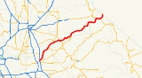
State Route 88 also known as the Carson Pass Highway, is a California State Highway that travels in an east–west direction, from Stockton
, crossing the Sierra Nevada at Carson Pass
, and ending at the border with Nevada
, whereupon it becomes Nevada State Route 88
, eventually terminating at U.S. Route 395.
Route 88 is one of only three routes to continue with the same route number after crossing into Nevada, the others being Routes 28
and 266
.
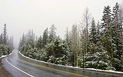
Unlike other two-lane California highways through the mountains (Routes 4, 108
and 120
), Route 88 stays open through winter, except during the worst snowstorms, making it the third major route through the mountains, after Interstate 80 and U.S. Route 50. In fact, Route 88 over the Carson Pass
is designated as Alternate U.S. 50, such that it may be used during flood
s of the American River
Canyon.
 SR 88 is part of the California Freeway and Expressway System
and is eligible for the State Scenic Highway System
. However, it is only a scenic highway as designated by Caltrans from the Dew Drop ranger station to the Nevada
state line. The road is kept open all winter but can be subject to restrictions or short-term closure due to snow (including avalanche
s) or ice; the current road condition is posted online by Caltrans.
SR 88 begins just outside Stockton
as Waterloo Road, heading northeast towards Waterloo
. The highway turns north at Waterloo, and SR 88 continues north to an intersection with SR 12, where the latter runs concurrently. SR 88 continues through Lockeford
and Clements
before continuing into Amador County
. Continuing northeast, SR 88 intersects the southern terminus of SR 124 and the eastern terminus of SR 104 before passing through the town of Sunnybrook
. In the community of Martell
, SR 88 turns south, running concurrently with SR 49 for a brief period of time, before turning northeast again and intersecting the eastern terminus of SR 26. The highway continues northeast into Pioneer Station, Buckhorn
, Cooks Station, and Hams Station before entering the state game refuge. SR 88 continues paralleling the county line with El Dorado County
in El Dorado National Forest before passing by Silver Lake and Kirkwood
, where SR 88 crosses into Alpine County
.
In Alpine County, SR 88 continues by Caples Lake before running concurrently with SR 89 until Woodfords
. The highway continues through Paynesville
before entering Nevada as Nevada State Route 88
.
completed in 1862, which was a major thoroughfare through the mountains, as California sent timber
, food, and particularly gold
to the east during the Civil War
. Completion of the First Transcontinental Railroad
in 1869 greatly decreased traffic on the wagon road.
{| class=wikitable
!County
!Location
!Postmile
!Destinations
!Notes
|-
|rowspan=8|San Joaquin
SJ 0.00-25.37
|
|0.00
|Waterloo Road
|Continuation beyond SR 99
|-
|
|0.00
|
|Interchange
|-
|
|6.52
|Eight Mile Road
|
|-
|
|bgcolor=#ddffdd|L12.24
|bgcolor=#ddffdd|
|bgcolor=#ddffdd|West end of SR 12 overlap
|-
|Lockeford
|14.08
|
|
|-
|rowspan=2|Clements
|
|Clements Road – Linden
|
|-bgcolor=#ddffdd
|19.17
|
|East end of SR 12 overlap
|-
|
|
|
|
|-
|rowspan=11|Amador
AMA 0.00-71.65
|
|5.53
|
|
|-
|
|bgcolor=#ddffdd|7.39
|bgcolor=#ddffdd|
|bgcolor=#ddffdd|West end of SR 104 overlap
|-
|
|bgcolor=#ddffdd|12.68
|bgcolor=#ddffdd|
|bgcolor=#ddffdd|East end of SR 104 overlap
|-
|Martell
|bgcolor=#ddffdd|14.25
5.93Indicates that the postmile represents the distance along SR 49
rather than SR 88.
|bgcolor=#ddffdd|
|bgcolor=#ddffdd|West end of SR 49 overlap
|-
|Jackson
|bgcolor=#ddffdd|4.03
14.29
|bgcolor=#ddffdd|
|bgcolor=#ddffdd|East end of SR 49 overlap
|-
|rowspan=2|Pine Grove
|22.69
|Ridge Road – Sutter Creek
|Unconstructed SR 104
west
|-
|23.36
|Pine Grove-Volcano Road – Volcano
|
|-
|
|R26.79
|
|
|-
|
|
|Volcano-Pioneer Road – Volcano
|
|-
|
|
|Omo Ranch Road – Pipi Valley, Omo Ranch
, Caldor
, Placerville
|
|-
|
|bgcolor=#ddffdd|R58.67
|bgcolor=#ddffdd|Mormon Emigrant Trail (US 50 Alt. west)
|bgcolor=#ddffdd|West end of US 50 Alt. overlap
|-
|rowspan=4|Alpine
ALP 0.00-25.28
|
|bgcolor=#ddffdd|13.40
|bgcolor=#ddffdd|
|bgcolor=#ddffdd|West end of SR 89 overlap; east end of US 50 Alt. overlap
|-
|Woodfords
|bgcolor=#ddffdd|19.22
|bgcolor=#ddffdd|
|bgcolor=#ddffdd|East end of SR 89 overlap
|-
|
|25.28
|colspan=2 align=center|Nevada state line
|-
|
|25.28
|
|Continuation beyond the Nevada
state line
Stockton, California
Stockton, California, the seat of San Joaquin County, is the fourth-largest city in the Central Valley of the U.S. state of California. With a population of 291,707 at the 2010 census, Stockton ranks as this state's 13th largest city...
, crossing the Sierra Nevada at Carson Pass
Carson Pass
Carson Pass is the Sierra Crest mountain pass over which State Route 88 crosses. The historic pass was a point on the Carson Trail during the California Gold Rush and was used for American Civil War shipping to California until the completion of the First Transcontinental Railroad...
, and ending at the border with Nevada
Nevada
Nevada is a state in the western, mountain west, and southwestern regions of the United States. With an area of and a population of about 2.7 million, it is the 7th-largest and 35th-most populous state. Over two-thirds of Nevada's people live in the Las Vegas metropolitan area, which contains its...
, whereupon it becomes Nevada State Route 88
Nevada State Route 88
State Route 88 is a state highway in Douglas County, Nevada. It runs from California State Route 88 at the California state line along Woodfords Road to U.S. Route 395 in Minden. Prior to 1957, the highway existed as State Route 37...
, eventually terminating at U.S. Route 395.
Route 88 is one of only three routes to continue with the same route number after crossing into Nevada, the others being Routes 28
California State Route 28
State Route 28 is a state highway in the U.S. state of California that travels along the northern shore of Lake Tahoe, starting at Route 89 in Tahoe City and ending at the Nevada state border, whereupon it becomes Nevada State Route 28...
and 266
California State Route 266
State Route 266 is a state highway in the U.S. state of California. The route is a connector between Nevada State Route 264 and Nevada State Route 266, and it can serve as transportation of agricultural goods between California and Nevada via the route's only junction State Route 168...
.
Unlike other two-lane California highways through the mountains (Routes 4, 108
California State Route 108
State Route 108, also known as Highway 108, is a numbered state highway in California. SR 108 runs generally northeast across central California from downtown Modesto near the SR 99/SR 132 interchange, crossing the Sierra Nevada at Sonora Pass, to U.S. Route 395 near the Nevada state line...
and 120
California State Route 120
State Route 120 , in northern California, runs between the Central Valley near Manteca, through Yosemite National Park, and ends at U.S. Route 6 in Mono County.-Route description:...
), Route 88 stays open through winter, except during the worst snowstorms, making it the third major route through the mountains, after Interstate 80 and U.S. Route 50. In fact, Route 88 over the Carson Pass
Carson Pass
Carson Pass is the Sierra Crest mountain pass over which State Route 88 crosses. The historic pass was a point on the Carson Trail during the California Gold Rush and was used for American Civil War shipping to California until the completion of the First Transcontinental Railroad...
is designated as Alternate U.S. 50, such that it may be used during flood
Flood
A flood is an overflow of an expanse of water that submerges land. The EU Floods directive defines a flood as a temporary covering by water of land not normally covered by water...
s of the American River
American River
The American River is a California watercourse noted as the site of Sutter's Mill, northwest of Placerville, California, where gold was found in 1848, leading to the California Gold Rush...
Canyon.
Route description
California Freeway and Expressway System
The California Freeway and Expressway System is a system of existing or planned freeways and expressways in the U.S. state of California. It is defined by the Streets and Highways Code.-List of roads in the system:*State Route 1 *State Route 2...
and is eligible for the State Scenic Highway System
State Scenic Highway System (California)
The State Scenic Highway System is a list of highways, mainly state highways, that have been designated by the California Department of Transportation as scenic highways. The California State Legislature, primarily through Section 263 of the Streets and Highways Code, makes highways eligible for...
. However, it is only a scenic highway as designated by Caltrans from the Dew Drop ranger station to the Nevada
Nevada
Nevada is a state in the western, mountain west, and southwestern regions of the United States. With an area of and a population of about 2.7 million, it is the 7th-largest and 35th-most populous state. Over two-thirds of Nevada's people live in the Las Vegas metropolitan area, which contains its...
state line. The road is kept open all winter but can be subject to restrictions or short-term closure due to snow (including avalanche
Avalanche
An avalanche is a sudden rapid flow of snow down a slope, occurring when either natural triggers or human activity causes a critical escalating transition from the slow equilibrium evolution of the snow pack. Typically occurring in mountainous terrain, an avalanche can mix air and water with the...
s) or ice; the current road condition is posted online by Caltrans.
SR 88 begins just outside Stockton
Stockton, California
Stockton, California, the seat of San Joaquin County, is the fourth-largest city in the Central Valley of the U.S. state of California. With a population of 291,707 at the 2010 census, Stockton ranks as this state's 13th largest city...
as Waterloo Road, heading northeast towards Waterloo
Waterloo, California
Waterloo is a census-designated place in San Joaquin County, California. Waterloo sits at an elevation of . The 2010 United States census reported Waterloo's population was 572.-Geography:...
. The highway turns north at Waterloo, and SR 88 continues north to an intersection with SR 12, where the latter runs concurrently. SR 88 continues through Lockeford
Lockeford, California
Lockeford is a census-designated place in San Joaquin County, California, United States. The population was 3,233 at the 2010 census, up from 3,179 at the 2000 census.-Geography:Lockeford is located at ....
and Clements
Clements, California
Clements is an unincorporated community in San Joaquin County, California, United States. Clements is located on California State Route 12 and California State Route 88 east-northeast of Lodi. Clements has a post office with ZIP code 95227, which was established in 1882. The community is named...
before continuing into Amador County
Amador County, California
Amador County is a county located in the Sierra Nevada of the U.S. state of California. As of the 2010 census, the population was 38,091. The county seat is Jackson.Amador County bills itself as "The Heart of the Mother Lode" and lies within the Gold Country...
. Continuing northeast, SR 88 intersects the southern terminus of SR 124 and the eastern terminus of SR 104 before passing through the town of Sunnybrook
Sunnybrook, California
Sunnybrook is an unincorporated community in Amador County, California. It is located on Mountain Spring Creek east of Ione. It lies at an elevation of 784 feet .The Vogans post office was operational from 1888 to 1889....
. In the community of Martell
Martell, California
Martell is a census-designated place in Amador County, California, United States. It is located northwest of Jackson, at an elevation of 1486 feet . The population was 282 at the 2010 census....
, SR 88 turns south, running concurrently with SR 49 for a brief period of time, before turning northeast again and intersecting the eastern terminus of SR 26. The highway continues northeast into Pioneer Station, Buckhorn
Buckhorn, Amador County, California
Buckhorn is a census-designated place in Amador County, California. Buckhorn sits at an elevation of 3,238 feet . The community is in ZIP code 95666 and area code 209. The 2010 United States census reported Buckhorn's population was 2,429....
, Cooks Station, and Hams Station before entering the state game refuge. SR 88 continues paralleling the county line with El Dorado County
El Dorado County, California
El Dorado County is a county located in the historic Gold Country in the Sierra Nevada Mountains and foothills of the U.S. state of California. The 2010 population was 181,058. The El Dorado county seat is in Placerville....
in El Dorado National Forest before passing by Silver Lake and Kirkwood
Kirkwood, California
Kirkwood is a census-designated place in Alpine and Amador counties, California, United States. The population was 158 at the 2010 census. Kirkwood's main attraction is the Kirkwood Mountain Resort. The town is accessible by State Route 88...
, where SR 88 crosses into Alpine County
Alpine County, California
Alpine County is the smallest county, by population, in the U.S. state of California. As of 2010, it had a population of 1,175, all rural. There are no incorporated cities in the county. The county seat is Markleeville...
.
In Alpine County, SR 88 continues by Caples Lake before running concurrently with SR 89 until Woodfords
Woodfords, California
Woodfords is an unincorporated community in Alpine County, California, near Markleeville. For census purposes, it is included in Alpine Village...
. The highway continues through Paynesville
Paynesville, California
Paynesville is an unincorporated community in Alpine County, California. It is located on the Carson River a quarter mile northeast of Woodfords, at an elevation of 5118 feet ....
before entering Nevada as Nevada State Route 88
Nevada State Route 88
State Route 88 is a state highway in Douglas County, Nevada. It runs from California State Route 88 at the California state line along Woodfords Road to U.S. Route 395 in Minden. Prior to 1957, the highway existed as State Route 37...
.
Historical landmarks
Listed in order from west to east.- the Trail of the 1844 John C. FrémontJohn C. FrémontJohn Charles Frémont , was an American military officer, explorer, and the first candidate of the anti-slavery Republican Party for the office of President of the United States. During the 1840s, that era's penny press accorded Frémont the sobriquet The Pathfinder...
Expedition, at the northwest corner of the Calaveras RiverCalaveras RiverThe Calaveras River is a river in the California Central Valley. It flows roughly southwest for from the confluence of its north and south forks in Calaveras County to its confluence with the San Joaquin River just west of the city of Stockton....
(postmile SJSan Joaquin County, CaliforniaSan Joaquin County is a county located in Central Valley of the U.S. state of California, just east of the San Francisco Bay Area. As of the 2010 census, the population was 685,306. The county seat is Stockton.-History:...
6.09) - Clinton , on Clinton Rd., south of the highway, in Pine Grove—Clinton was the center of a placer miningPlacer miningPlacer mining is the mining of alluvial deposits for minerals. This may be done by open-pit or by various surface excavating equipment or tunneling equipment....
community during the 1850s and of quartzQuartzQuartz is the second-most-abundant mineral in the Earth's continental crust, after feldspar. It is made up of a continuous framework of SiO4 silicon–oxygen tetrahedra, with each oxygen being shared between two tetrahedra, giving an overall formula SiO2. There are many different varieties of quartz,...
mining as late as the 1880s. This town once decided Amador County elections as its votes were always counted last. - Irishtown, at the intersection of Pine Grove Wieland Rd. in Pine Grove—This was an important stopping place for emigrants on their way to the southern mines. The first white settlers on this spot found it a "city of wigwamWigwamA wigwam or wickiup is a domed room dwelling used by certain Native American tribes. The term wickiup is generally used to label these kinds of dwellings in American Southwest and West. Wigwam is usually applied to these structures in the American Northeast...
s," and hundreds of mortars in the rocks testify that this was a favorite Indian camping ground. - Mount Zion State ParkMount Zion State ParkMount Zion Demonstration State Forest is located in the town of Pine Grove, Amador County, California. It features a ranger lookout station and microwave tower atop Mount Zion, which is accessed via Mount Zion Road from California_State_Route_88....
, Pine Grove - Indian Grinding Rock State Historic ParkIndian Grinding Rock State Historic ParkChaw'se Indian Grinding Rock State Historic Park is a historical state park located in the Sierra Nevada foothills of California, eight miles east of Jackson...
, Pine Grove - Eldorado National ForestEldorado National ForestEldorado National Forest is a U.S. National Forest located in the central Sierra Nevada mountain range, in eastern Eldorado National Forest is a [[U.S. National Forest]] located in the central [[Sierra Nevada |Sierra Nevada]] [[mountain range]], in eastern Eldorado National Forest is a [[U.S...
, Amador Ranger Station, PioneerPioneer, CaliforniaPioneer is a census-designated place in Amador County, California. It is located east-northeast of Pine Grove, at an elevation of 2986 feet , along State Route 88. The community is in ZIP code 95666 and area code 209... - Maiden's Grave, burial place of Rachel Melton (d. 1850), a young girl who died while traveling to California via covered wagon (postmile AMAAmador County, CaliforniaAmador County is a county located in the Sierra Nevada of the U.S. state of California. As of the 2010 census, the population was 38,091. The county seat is Jackson.Amador County bills itself as "The Heart of the Mother Lode" and lies within the Gold Country...
61.3) - The Old Emigrant Road was a long loop around the Silver Lake basin, starting from Caples Lake and reaching an elevation of 9,640 feet (2,938 m) at one place. This difficult portion of the road was used by thousands of vehicles from 1848 to 1863, when a better route was blasted out of the face of the cliff at Carson Spur (the present highway route). There are two markers. One is at the intersection of Mud Lake Rd (postmile AMA 63.1). The second marker is at postmile ALPAlpine County, CaliforniaAlpine County is the smallest county, by population, in the U.S. state of California. As of 2010, it had a population of 1,175, all rural. There are no incorporated cities in the county. The county seat is Markleeville...
2.4, at Caples Lake. - Cooks StationCooks StationCooks Station , elevation , is a roadside stop on State Route 88 in Amador County in the Sierra Nevada mountains.Built in 1863 as part of the Volcano cutoff of the Carson Emigrant Trail, Cooks Station is one of two remaining "stations" on the highway among many that sprang up after the road was...
, a roadside stop built in 1863 and still in operation, elevation 5000 feet (1,524 m) - Ham's Station is a roadside stop still in operation as a restaurant and convenience store, located at 38.544406°N 120.377471°W at an elevation of 6000 feet (1,828.8 m). Ham's Station was built by 1879 and originally served as a toll station on the highway. Both Cooks and Ham's stations are routinely used by Caltrans to indicate points where tire chains are required for continued travel during snowstorms, as they are two of the only landmarks between PioneerPioneer, CaliforniaPioneer is a census-designated place in Amador County, California. It is located east-northeast of Pine Grove, at an elevation of 2986 feet , along State Route 88. The community is in ZIP code 95666 and area code 209...
and the junction with State Route 89California State Route 89State Route 89 is a California State Highway that travels in the north–south direction, and is the major thoroughfare for many mountain communities. It starts from U.S. Route 395 near Topaz Lake, winding its way up to the Monitor Pass, down to the Carson River, and up again over the Luther...
. - Kirkwood Mountain ResortKirkwood Mountain ResortKirkwood Mountain Resort is a year-round resort in Kirkwood, California south of Lake Tahoe that focuses on skiing and snowboarding in winter and hiking and mountain-biking in summer. Kirkwood is one of the region's larger resorts, and is well known for having one of the highest average snowfalls...
, KirkwoodKirkwood, CaliforniaKirkwood is a census-designated place in Alpine and Amador counties, California, United States. The population was 158 at the 2010 census. Kirkwood's main attraction is the Kirkwood Mountain Resort. The town is accessible by State Route 88... - Kirkwood's, a resort, stage station, and post office originally built by Zack Kirkwood in 1864. The building straddles the AlpineAlpine County, CaliforniaAlpine County is the smallest county, by population, in the U.S. state of California. As of 2010, it had a population of 1,175, all rural. There are no incorporated cities in the county. The county seat is Markleeville...
–AmadorAmador County, CaliforniaAmador County is a county located in the Sierra Nevada of the U.S. state of California. As of the 2010 census, the population was 38,091. The county seat is Jackson.Amador County bills itself as "The Heart of the Mother Lode" and lies within the Gold Country...
county line. - The Kit CarsonKit CarsonChristopher Houston "Kit" Carson was an American frontiersman and Indian fighter. Carson left home in rural present-day Missouri at age 16 and became a Mountain man and trapper in the West. Carson explored the west to California, and north through the Rocky Mountains. He lived among and married...
Marker (CHL #315, postmile ALP 5.2), at the summit of Carson PassCarson PassCarson Pass is the Sierra Crest mountain pass over which State Route 88 crosses. The historic pass was a point on the Carson Trail during the California Gold Rush and was used for American Civil War shipping to California until the completion of the First Transcontinental Railroad...
, marks where Carson carved his name into a tree in 1844 while guiding John C. Frémont through the Sierra Nevada. The original can be found at Sutter's FortSutter's FortSutter's Fort State Historic Park is a state-protected park in Sacramento, California which includes Sutter's Fort and the California State Indian Museum. Begun in 1839 and originally called "New Helvetia" by its builder, John Sutter, the fort was a 19th century agricultural and trade colony in...
, SacramentoSacramento, CaliforniaSacramento is the capital city of the U.S. state of California and the county seat of Sacramento County. It is located at the confluence of the Sacramento River and the American River in the northern portion of California's expansive Central Valley. With a population of 466,488 at the 2010 census,...
. - On some large rocks near Carson Pass, a group of pioneers inscribed their names and the emblem of the Independent Order of Odd FellowsIndependent Order of Odd FellowsThe Independent Order of Odd Fellows , also known as the Three Link Fraternity, is an altruistic and benevolent fraternal organization derived from the similar British Oddfellows service organizations which came into being during the 18th century, at a time when altruistic and charitable acts were...
in 1849 (postmile ALP 5.3).
History
A portion of Route 88 (from Antelope Springs to the border) started as the Amador/Nevada Wagon Route, a toll roadToll road
A toll road is a privately or publicly built road for which a driver pays a toll for use. Structures for which tolls are charged include toll bridges and toll tunnels. Non-toll roads are financed using other sources of revenue, most typically fuel tax or general tax funds...
completed in 1862, which was a major thoroughfare through the mountains, as California sent timber
Timber
Timber may refer to:* Timber, a term common in the United Kingdom and Australia for wood materials * Timber, Oregon, an unincorporated community in the U.S...
, food, and particularly gold
Gold
Gold is a chemical element with the symbol Au and an atomic number of 79. Gold is a dense, soft, shiny, malleable and ductile metal. Pure gold has a bright yellow color and luster traditionally considered attractive, which it maintains without oxidizing in air or water. Chemically, gold is a...
to the east during the Civil War
American Civil War
The American Civil War was a civil war fought in the United States of America. In response to the election of Abraham Lincoln as President of the United States, 11 southern slave states declared their secession from the United States and formed the Confederate States of America ; the other 25...
. Completion of the First Transcontinental Railroad
First Transcontinental Railroad
The First Transcontinental Railroad was a railroad line built in the United States of America between 1863 and 1869 by the Central Pacific Railroad of California and the Union Pacific Railroad that connected its statutory Eastern terminus at Council Bluffs, Iowa/Omaha, Nebraska The First...
in 1869 greatly decreased traffic on the wagon road.
Major intersections
- Note: Except where prefixed with a letter, postmiles were measured in 1964, based on the alignment as it existed at that time, and do not necessarily reflect current mileage. The numbers reset at county lines; the start and end postmiles in each county are given in the county column.
{| class=wikitable
!County
!Location
!Postmile
!Destinations
!Notes
|-
|rowspan=8|San Joaquin
San Joaquin County, California
San Joaquin County is a county located in Central Valley of the U.S. state of California, just east of the San Francisco Bay Area. As of the 2010 census, the population was 685,306. The county seat is Stockton.-History:...
SJ 0.00-25.37
|
|0.00
|Waterloo Road
|Continuation beyond SR 99
|-
|
|0.00
|
|Interchange
|-
|
|6.52
|Eight Mile Road
|
|-
|
|bgcolor=#ddffdd|L12.24
|bgcolor=#ddffdd|
|bgcolor=#ddffdd|West end of SR 12 overlap
|-
|Lockeford
Lockeford, California
Lockeford is a census-designated place in San Joaquin County, California, United States. The population was 3,233 at the 2010 census, up from 3,179 at the 2000 census.-Geography:Lockeford is located at ....
|14.08
|
|
|-
|rowspan=2|Clements
Clements, California
Clements is an unincorporated community in San Joaquin County, California, United States. Clements is located on California State Route 12 and California State Route 88 east-northeast of Lodi. Clements has a post office with ZIP code 95227, which was established in 1882. The community is named...
|
|Clements Road – Linden
Linden, California
Linden is a census-designated place in San Joaquin County, California, United States. The population was 1,784 at the 2010 census, up from 1,103 at the 2000 census...
|
|-bgcolor=#ddffdd
|19.17
|
|East end of SR 12 overlap
|-
|
|
|
|
|-
|rowspan=11|Amador
Amador County, California
Amador County is a county located in the Sierra Nevada of the U.S. state of California. As of the 2010 census, the population was 38,091. The county seat is Jackson.Amador County bills itself as "The Heart of the Mother Lode" and lies within the Gold Country...
AMA 0.00-71.65
|
|5.53
|
|
|-
|
|bgcolor=#ddffdd|7.39
|bgcolor=#ddffdd|
|bgcolor=#ddffdd|West end of SR 104 overlap
|-
|
|bgcolor=#ddffdd|12.68
|bgcolor=#ddffdd|
|bgcolor=#ddffdd|East end of SR 104 overlap
|-
|Martell
Martell, California
Martell is a census-designated place in Amador County, California, United States. It is located northwest of Jackson, at an elevation of 1486 feet . The population was 282 at the 2010 census....
|bgcolor=#ddffdd|14.25
5.93Indicates that the postmile represents the distance along SR 49
California State Route 49
State Route 49 is a north–south state highway in the U.S. state of California that passes through many historic mining communities of the 1849 California gold rush. Highway 49 is numbered after the "49ers", the waves of immigrants who swept into the area looking for gold, and a portion of it...
rather than SR 88.
|bgcolor=#ddffdd|
|bgcolor=#ddffdd|West end of SR 49 overlap
|-
|Jackson
Jackson, California
Jackson is the county seat of Amador County, California. The population was 4,651 at the 2010 census, up from 3,989 at the 2000 census...
|bgcolor=#ddffdd|4.03
14.29
|bgcolor=#ddffdd|
|bgcolor=#ddffdd|East end of SR 49 overlap
|-
|rowspan=2|Pine Grove
|22.69
|Ridge Road – Sutter Creek
Sutter Creek, California
Sutter Creek is a city in Amador County, California, United States. The population was 2,501 at the 2010 census, up from 2,303 at the 2000 census...
|Unconstructed SR 104
California State Route 104
State Route 104 is a west–east state highway in California's Central Valley. It connects State Route 99 near Galt to State Route 49 in Sutter Creek via the city of Ione. It is known as Twin Cities Road from its western terminus up until just before Ione...
west
|-
|23.36
|Pine Grove-Volcano Road – Volcano
Volcano, California
Volcano is a census-designated place in Amador County, California. It lies at an elevation of 2070 feet . The population was 115 at the 2010 census. It is located at , just north of Pine Grove. The town is registered as California Historical Landmark #29...
|
|-
|
|R26.79
|
|
|-
|
|
|Volcano-Pioneer Road – Volcano
Volcano, California
Volcano is a census-designated place in Amador County, California. It lies at an elevation of 2070 feet . The population was 115 at the 2010 census. It is located at , just north of Pine Grove. The town is registered as California Historical Landmark #29...
|
|-
|
|
|Omo Ranch Road – Pipi Valley, Omo Ranch
Omo Ranch, California
Omo Ranch is an unincorporated community in El Dorado County, California. It is located south-southeast of Camino, at an elevation of 3612 feet ....
, Caldor
Caldor, California
Caldor is an unincorporated community in El Dorado County, California. It lies at an elevation of 4442 feet . Caldor was linked to Diamond Springs by the Diamond and Caldor Railway....
, Placerville
Placerville, California
Placerville is the county seat of El Dorado County, California. The population was 10,389 at the 2010 census, up from 9,610 at the 2000 census. It is part of the Sacramento–Arden-Arcade–Roseville Metropolitan Statistical Area.-Geography:...
|
|-
|
|bgcolor=#ddffdd|R58.67
|bgcolor=#ddffdd|Mormon Emigrant Trail (US 50 Alt. west)
|bgcolor=#ddffdd|West end of US 50 Alt. overlap
|-
|rowspan=4|Alpine
Alpine County, California
Alpine County is the smallest county, by population, in the U.S. state of California. As of 2010, it had a population of 1,175, all rural. There are no incorporated cities in the county. The county seat is Markleeville...
ALP 0.00-25.28
|
|bgcolor=#ddffdd|13.40
|bgcolor=#ddffdd|
|bgcolor=#ddffdd|West end of SR 89 overlap; east end of US 50 Alt. overlap
|-
|Woodfords
Woodfords, California
Woodfords is an unincorporated community in Alpine County, California, near Markleeville. For census purposes, it is included in Alpine Village...
|bgcolor=#ddffdd|19.22
|bgcolor=#ddffdd|
|bgcolor=#ddffdd|East end of SR 89 overlap
|-
|
|25.28
|colspan=2 align=center|Nevada state line
|-
|
|25.28
|
|Continuation beyond the Nevada
Nevada
Nevada is a state in the western, mountain west, and southwestern regions of the United States. With an area of and a population of about 2.7 million, it is the 7th-largest and 35th-most populous state. Over two-thirds of Nevada's people live in the Las Vegas metropolitan area, which contains its...
state line