
.gif)
Sierra Nevada (US)
Encyclopedia
The Sierra Nevada (ˈsjera neˈβaða, snowy mountain range) is a mountain range in the U.S. states of California
and Nevada
, between the California Central Valley
and the Basin and Range Province. The Sierra runs 400 miles (643.7 km) north-to-south, and is approximately 70 miles (112.7 km) across east-to-west. Notable Sierra features include Lake Tahoe
, the largest alpine lake
in North America; Mount Whitney
at 14,505 feet (4,421 m), the highest point in the contiguous United States
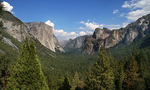
; and Yosemite Valley
sculpted by glaciers out of 100-million-year-old granite
. The Sierra is home to three national parks, 20 wilderness areas, and two national monuments. These areas include Yosemite
, Sequoia
and Kings Canyon National Park
s.
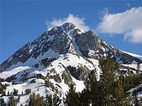
The character of the range is shaped by its geology and ecology. More than 100 million years ago, granite formed deep underground. The range started to uplift 4 million years ago, and erosion by glaciers exposed the granite and formed the light-colored mountains and cliffs that make up the range. The uplift caused a wide range of elevations and climates in the Sierra, which are reflected by the presence of five life zones.
The Sierra Nevada was home to several Native American tribes. The first European to sight the range was Pedro Fages
in 1772. The range was explored between 1844 and 1912.
and Fredonyer Pass
in the north to Tehachapi Pass
in the south. It is bounded on the west by California
's Central Valley
and on the east by the Basin and Range Province. Physiographically, the Sierra is a section of the Cascade-Sierra Mountains province, which in turn is part of the larger Pacific Mountain System physiographic division.
West-to-east, the Sierra Nevada's elevation increases gradually from the California Central Valley
to the crest, while the east slope forms the steep Sierra Escarpment
. The range is drained on its northwest slopes by the Sacramento River
and to the west-southwest by the San Joaquin River
, two major Central Valley watercourses that ultimately discharge to the Pacific Ocean
. Smaller rivers of the west slope include the Feather
, Yuba
, American
, Mokelumne
, Stanislaus
and Tuolumne
. The southern part of the mountains are drained by four rivers called the Kings
, Kaweah
, Tule
, and Kern
. These rivers flow into an endorheic basin called Tulare Lake
, but historically joined the San Joaquin during wet years.
To the east, the melting snow of the mountains forms many small rivers that flow out into the Great Basin
of Nevada
and eastern California. From north to south, the Susan River
flows into intermittent Honey Lake
; the Truckee River
flows from massive Lake Tahoe
into Pyramid Lake; the Carson River
runs into Carson Sink
; the Walker River into Walker Lake
; Rush, Lee Vining
and Mill Creeks into Mono Lake
; and the Owens River
into the dry Owens Lake
. None of the east-side rivers reach the sea; however, many of the streams from Mono Lake southwards are diverted into the Los Angeles Aqueduct
and their water shipped to Southern California
.
The height of the mountains in the Sierra Nevada increases gradually from north to south. Between Fredonyer Pass and Lake Tahoe, the peaks range from 5000 feet (1,524 m) to more than 9000 feet (2,743.2 m). The crest near Lake Tahoe is roughly 9000 feet (2,743.2 m) high, with several peaks approaching the height of Freel Peak
[10881 feet (3,316.5 m)]. Further south, the highest peak in Yosemite National Park is Mount Lyell [13120 feet (3,999 m)]. The Sierra rise to almost 14000 feet (4,267.2 m) with Mount Humphreys
near Bishop, California
. Finally, near Independence
, Mount Whitney
is at 14505 feet (4,421.1 m), the highest point in the contiguous United States
.
South of Mount Whitney, the range quickly dwindles. The crest elevation is almost 10000 feet (3,048 m) near Lake Isabella
, but south of the lake, the peaks reach only to a modest 8000 feet (2,438.4 m).
period. This granite is mostly found east of the crest and north of 37.2°N. In the Triassic and into the Jurassic
, an island arc
collided with the west coast of North America
and raised a set of mountain
s, in an event called the Nevadan orogeny
.
 In the Cretaceous
, a subduction zone formed at the edge of the continent. This means that an oceanic plate started to dive beneath the North American plate
. Magma formed through the subduction of the ancient Farallon Plate
rose in plumes (plutons) deep underground, their combined mass forming what is called the Sierra Nevada batholith
. These plutons formed at various times, from 115-million to 87-million years ago. The earlier plutons formed in the western half of the Sierra, while the later plutons formed in the eastern half of the Sierra. By 65-million years ago, the proto-Sierra Nevada had been worn down to a range of rolling low mountains, a few thousand feet high.
Twenty million years ago, crustal extension associated with the Basin and Range Province caused extensive volcanism in the Sierra. About 4-million years ago, the Sierra Nevada started to form: a block of crust
between the Coast Range and the Basin and Range Province started to tilt to the west. Rivers started cutting deep canyons on both sides of the range. The Earth's climate cooled, and ice age
s started about 2.5-million years ago. Glacier
s carved out characteristic U-shaped canyons throughout the Sierra. The combination of river and glacier erosion exposed the uppermost portions of the plutons emplaced millions of years before, leaving only a remnant of metamorphic rock
on top of some Sierra peaks.
Uplift of the Sierra Nevada continues today, especially along its eastern side. This uplift causes large earthquakes, such as the Lone Pine earthquake
of 1872.
The climate of the Sierra Nevada is influenced by the Mediterranean climate
of California. During the fall, winter and spring, precipitation in the Sierra ranges from 20 to 80 in (508 to 2,032 mm) where it occurs mostly as snow above 6000 ft (1,828.8 m). Summers are dry with low humidity; however, afternoon thunderstorms are not uncommon, particularly during the North American Monsoon
. Summer high temperatures average 42 to 90 degrees Fahrenheit. The growing season lasts 20 to 230 days, strongly dependent on elevation.
The Sierra Nevada snowpack is the major source of water and a significant source of electric power generation in California. Many reservoirs were constructed in the canyons of the Sierra throughout the 20th century, Several major aqueducts serving both agriculture and urban areas distribute Sierra water throughout the state. However, the Sierra casts a rain shadow
, which greatly affects the climate and ecology of the central Great Basin
. This rain shadow is largely responsible for Nevada being the driest state in the United States.
The height of the range and the steepness of the Sierra Escarpment, particularly at the southern end of the range produces a wind phenomenon known as the "Sierra Rotor". This is a horizontal rotation of the atmosphere just east of the crest of the Sierras, set in motion as an effect of strong westerly winds.
, each of which is defined by its climate and supports a number of interdependent species. Life in the higher elevation zones adapted to colder weather, and to most of the precipitation falling as snow. The rain shadow
of the Sierra causes the eastern slope to be warmer and drier: each life zone
is higher in the east. A list of biotic zones, and corresponding elevations, is presented below:
of Paleo-Indians in northcentral Sierra Nevada during the period of 3,000 BC to 500 AD. The earliest identified sustaining indigenous people
in the Sierra Nevada were the Northern Paiute
tribes of Native American
on the east side, with the Mono tribe
and Sierra Miwok
tribe on the western side, and the Kawaiisu
tribe in the southern Sierra. Today, some mountain passes, such as Duck Pass with obsidian
arrowhead
s, are artifact locations from historic intertribal trade route trails. The California and Sierra Native American tribes were predominantly peaceful, with occasional territorial disputes between the Paiute and Sierra Miwok tribes in the mountains. Washo
and Maidu
were also in this area prior to the era of European exploration and displacement.
to describe a Pacific Coast Range
(Santa Cruz Mountains
), the term "sierra nevada" was a general identification of less familiar ranges toward the interior, In 1777, Pedro Font's map applied the name to the range currently known as the Sierra Nevada.
The literal translation is "snowy mountains," from sierra "a range of hills," 1610s, from Spanish sierra "jagged mountain range," lit. "saw," from Latin serra "a saw";
and from fem. of Spanish nevado "snowy."
, accompanied by Kit Carson
, was the first European to see Lake Tahoe
. The Frémont party camped at 8050 ft (2,453.6 m).
By 1860, California Gold Rush
populated the flanks of the Sierra Nevada, leaving most of the Sierra unexplored. The state legislature authorized the California Geological Survey
to officially explore the Sierra (and survey the rest of the state). Josiah Whitney
was appointed to head the survey. Men of the survey, including William H. Brewer
, Charles F. Hoffmann
and Clarence King
, explored the backcountry of what would become Yosemite National Park
in 1863. In 1864 they explored the area around Kings Canyon
. In 1869, John Muir
started his wanderings in the Sierra Nevada range, and in 1871 King was the first to climb Mount Langley
and that year fishermen were the first to climb Mount Whitney
. From 1892–7 Theodore Solomons
made the first attempt to map a route along the crest of the Sierra.
Other people finished exploring and mapping the Sierra. Bolton Coit Brown explored the Kings River
watershed in 1895–1899. Joseph N. LeConte mapped the area around Yosemite National Park
and what would become Kings Canyon National Park
. James S. Hutchinson
, a noted mountaineer, climbed the Palisades
(1904) and Mount Humphreys
(1905). By 1912, the USGS published a set of maps of the Sierra Nevada, and the era of exploration was over.
Yosemite Valley
was first protected by the federal government in 1864. The Valley and Mariposa Grove
were ceded to California
in 1866 and turned into a state park. John Muir perceived overgrazing
by sheep
and logging of Giant Sequoia to be a problem in the Sierra. Muir successfully lobbied for the protection of the rest of Yosemite National Park: Congress created an Act to protect the park in 1890. The Valley and Mariposa Grove were added to the Park in 1906. In the same year, Sequoia National Park
was formed to protect the Giant Sequoia: all logging of the Sequoia ceased at that time.
In 1903, the city of San Francisco proposed building a hydroelectric dam to flood Hetch Hetchy Valley
. The city and the Sierra Club
argued over the dam for 10 years, until the U.S. Congress passed the Raker Act
in 1913 and allowed dam building to proceed. O'Shaughnessy Dam
was completed in 1923.
Between 1912 and 1918, Congress debated three times to protect Lake Tahoe in a national park. None of these efforts succeeded, and after World War II
, towns such as South Lake Tahoe
grew around the shores of the lake. By 1980, the permanent population of the Lake Tahoe area grew to 50,000, while the summer population grew to 90,000. The development around Lake Tahoe affected the clarity of the lake water. In order to preserve the lake's clarity, construction in the Tahoe basin is currently regulated by the Tahoe Regional Planning Agency
.
As the twentieth century progressed, more of the Sierra became available for recreation: other forms of economic activity decreased. The John Muir Trail
, a trail that followed the Sierra crest from Yosemite Valley to Mount Whitney
, was funded in 1915 and finished in 1938. Kings Canyon National Park
was formed in 1940 to protect the deep canyon of the Kings River
.
By 1964, the Wilderness Act
protected portions of the Sierra as primitive areas where humans are simply temporary visitors. Gradually, 20 wilderness areas were established to protect scenic backcountry
of the Sierra. These wilderness areas include the John Muir Wilderness
(protecting the eastern slope of the Sierra and the area between Yosemite and Kings Canyon Parks), and wilderness within each of the National Parks.
 Today, much of the Sierra Nevada is owned by the U.S. Federal government and is either protected from development or is strictly managed. The three National Parks (Yosemite
, Kings Canyon
, Sequoia
), two National Monument (Devils Postpile
, Giant Sequoia
), and 20 wilderness areas lie within the Sierra. These areas protect 15.4% of the Sierra's 63118 square kilometre from logging and grazing.
The United States Forest Service
and the Bureau of Land Management
currently control 52% of the land in the Sierra Nevada. Logging and grazing is generally allowed on land controlled by these agencies, under federal regulations that balance recreation and development on the land.
The California Bighorn Sheep Zoological Area near Mount Williamson
in the southern Sierra was established to protect the endangered Sierra Nevada Bighorn Sheep
. Starting in 1981, hikers were unable to enter the Area from May 15 through December 15, in order to protect the sheep. As of 2010, the restriction has been lifted and access to the Area is open for the whole year.
California
California is a state located on the West Coast of the United States. It is by far the most populous U.S. state, and the third-largest by land area...
and Nevada
Nevada
Nevada is a state in the western, mountain west, and southwestern regions of the United States. With an area of and a population of about 2.7 million, it is the 7th-largest and 35th-most populous state. Over two-thirds of Nevada's people live in the Las Vegas metropolitan area, which contains its...
, between the California Central Valley
California Central Valley
California's Central Valley is a large, flat valley that dominates the central portion of California. It is home to California's most productive agricultural efforts. The valley stretches approximately from northwest to southeast inland and parallel to the Pacific Ocean coast. Its northern half is...
and the Basin and Range Province. The Sierra runs 400 miles (643.7 km) north-to-south, and is approximately 70 miles (112.7 km) across east-to-west. Notable Sierra features include Lake Tahoe
Lake Tahoe
Lake Tahoe is a large freshwater lake in the Sierra Nevada of the United States. At a surface elevation of , it is located along the border between California and Nevada, west of Carson City. Lake Tahoe is the largest alpine lake in North America. Its depth is , making it the USA's second-deepest...
, the largest alpine lake
Alpine lake
Alpine lakes are classified as lakes or reservoirs at high altitudes, usually starting around 5,000 feet in elevation above sea level or above the tree line....
in North America; Mount Whitney
Mount Whitney
Mount Whitney is the highest summit in the contiguous United States with an elevation of . It is on the boundary between California's Inyo and Tulare counties, west-northwest of the lowest point in North America at Badwater in Death Valley National Park...
at 14,505 feet (4,421 m), the highest point in the contiguous United States
Contiguous United States
The contiguous United States are the 48 U.S. states on the continent of North America that are south of Canada and north of Mexico, plus the District of Columbia....
; and Yosemite Valley
Yosemite Valley
Yosemite Valley is a glacial valley in Yosemite National Park in the western Sierra Nevada mountains of California, carved out by the Merced River. The valley is about long and up to a mile deep, surrounded by high granite summits such as Half Dome and El Capitan, and densely forested with pines...
sculpted by glaciers out of 100-million-year-old granite
Granite
Granite is a common and widely occurring type of intrusive, felsic, igneous rock. Granite usually has a medium- to coarse-grained texture. Occasionally some individual crystals are larger than the groundmass, in which case the texture is known as porphyritic. A granitic rock with a porphyritic...
. The Sierra is home to three national parks, 20 wilderness areas, and two national monuments. These areas include Yosemite
Yosemite National Park
Yosemite National Park is a United States National Park spanning eastern portions of Tuolumne, Mariposa and Madera counties in east central California, United States. The park covers an area of and reaches across the western slopes of the Sierra Nevada mountain chain...
, Sequoia
Sequoia National Park
Sequoia National Park is a national park in the southern Sierra Nevada east of Visalia, California, in the United States. It was established on September 25, 1890. The park spans . Encompassing a vertical relief of nearly , the park contains among its natural resources the highest point in the...
and Kings Canyon National Park
Kings Canyon National Park
Kings Canyon National Park is a National Park in the southern Sierra Nevada, east of Fresno, California. The park was established in 1940 and covers...
s.
The character of the range is shaped by its geology and ecology. More than 100 million years ago, granite formed deep underground. The range started to uplift 4 million years ago, and erosion by glaciers exposed the granite and formed the light-colored mountains and cliffs that make up the range. The uplift caused a wide range of elevations and climates in the Sierra, which are reflected by the presence of five life zones.
The Sierra Nevada was home to several Native American tribes. The first European to sight the range was Pedro Fages
Pedro Fages
Pere Fages Beleta , nicknamed L'Ós , was a soldier, explorer, and the second Spanish military Governor of Las Californias Province of New Spain from 1770 to 1774, and the Governor of Las Californias from 1782 to 1791.-Life:...
in 1772. The range was explored between 1844 and 1912.
Geography
The Sierra Nevada stretches from the Susan RiverSusan River (California)
The Susan River is a northeastern California river of approximately length that drains from an arid plateau of volcanic highlands along the Great Basin Divide to intermittent Honey Lake. The river flows from eastern Lassen County from east of Lassen Volcanic National Park generally east past...
and Fredonyer Pass
Fredonyer Pass
Fredonyer Pass is a high mountain pass in Lassen County, California. The pass is slightly higher than Morgan Summit to the west. Snow falls on the pass during winter....
in the north to Tehachapi Pass
Tehachapi Pass
Tehachapi Pass is a mountain pass crossing the Tehachapi Mountains in Kern County, California in the United States. The route over the pass connects the San Joaquin Valley to the Mojave Desert...
in the south. It is bounded on the west by California
California
California is a state located on the West Coast of the United States. It is by far the most populous U.S. state, and the third-largest by land area...
's Central Valley
California Central Valley
California's Central Valley is a large, flat valley that dominates the central portion of California. It is home to California's most productive agricultural efforts. The valley stretches approximately from northwest to southeast inland and parallel to the Pacific Ocean coast. Its northern half is...
and on the east by the Basin and Range Province. Physiographically, the Sierra is a section of the Cascade-Sierra Mountains province, which in turn is part of the larger Pacific Mountain System physiographic division.
West-to-east, the Sierra Nevada's elevation increases gradually from the California Central Valley
California Central Valley
California's Central Valley is a large, flat valley that dominates the central portion of California. It is home to California's most productive agricultural efforts. The valley stretches approximately from northwest to southeast inland and parallel to the Pacific Ocean coast. Its northern half is...
to the crest, while the east slope forms the steep Sierra Escarpment
Escarpment
An escarpment is a steep slope or long cliff that occurs from erosion or faulting and separates two relatively level areas of differing elevations.-Description and variants:...
. The range is drained on its northwest slopes by the Sacramento River
Sacramento River
The Sacramento River is an important watercourse of Northern and Central California in the United States. The largest river in California, it rises on the eastern slopes of the Klamath Mountains, and after a journey south of over , empties into Suisun Bay, an arm of the San Francisco Bay, and...
and to the west-southwest by the San Joaquin River
San Joaquin River
The San Joaquin River is the largest river of Central California in the United States. At over long, the river starts in the high Sierra Nevada, and flows through a rich agricultural region known as the San Joaquin Valley before reaching Suisun Bay, San Francisco Bay, and the Pacific Ocean...
, two major Central Valley watercourses that ultimately discharge to the Pacific Ocean
Pacific Ocean
The Pacific Ocean is the largest of the Earth's oceanic divisions. It extends from the Arctic in the north to the Southern Ocean in the south, bounded by Asia and Australia in the west, and the Americas in the east.At 165.2 million square kilometres in area, this largest division of the World...
. Smaller rivers of the west slope include the Feather
Feather River
The Feather River is the principal tributary of the Sacramento River, in the Sacramento Valley of Northern California. The river's main stem is about long. Its length to its most distant headwater tributary is about . Its drainage basin is about...
, Yuba
Yuba River
The Yuba River is a tributary of the Feather River in the Sacramento Valley of the U.S. state of California. It is one of the Feather's most important branches, providing about a third of its flow. The main stem of the river is about long, and its headwaters are split into North, Middle and South...
, American
American River
The American River is a California watercourse noted as the site of Sutter's Mill, northwest of Placerville, California, where gold was found in 1848, leading to the California Gold Rush...
, Mokelumne
Mokelumne River
The Mokelumne River is a river in Northern California. The Upper Mokelumne River originates in the Sierra Nevada mountain range and flows into Pardee Reservoir and then Camanche Reservoir in the Sierra foothills. The Lower Mokelumne River refers to the portion of the river below Camanche Dam...
, Stanislaus
Stanislaus River
The Stanislaus River in California is one of the largest tributaries of the San Joaquin River. The river is long and has north, middle and south forks...
and Tuolumne
Tuolumne River
The Tuolumne River is a California river that flows nearly from the central Sierra Nevada to the San Joaquin River in the Central Valley...
. The southern part of the mountains are drained by four rivers called the Kings
Kings River (California)
The Kings River is a major river of south-central California. About long, it drains an area of the high western Sierra Nevada and the Central Valley. A large alluvial fan has formed where the river's gradient decreases in the Central Valley so the river divides into distributaries...
, Kaweah
Kaweah River
The Kaweah River in the U.S. state of California flows westward from the foothills of the Sierra Nevada into the Central Valley. It rises in forks in the southern Sierra Nevada inside Sequoia National Park, the longest of which is the Middle Fork, about long...
, Tule
Tule River
The Tule River, also called Rio de San Pedro or Rio San Pedro, is a river in Tulare County in the U.S. state of California. The river originates in the Sierra Nevada east of Porterville and consists of three forks, North, Middle and South. The North Fork and Middle Fork meet above Springville. The...
, and Kern
Kern River
The Kern River is a river in the U.S. state of California, approximately long. It drains an area of the southern Sierra Nevada mountains northeast of Bakersfield. Fed by snowmelt near Mount Whitney, the river passes through scenic canyons in the mountains and is a popular destination for...
. These rivers flow into an endorheic basin called Tulare Lake
Tulare Lake
Tulare Lake, named Laguna de Tache by the Spanish, is a fresh-water dry lake with residual wetlands and marshes in southern San Joaquin Valley, California...
, but historically joined the San Joaquin during wet years.
To the east, the melting snow of the mountains forms many small rivers that flow out into the Great Basin
Great Basin
The Great Basin is the largest area of contiguous endorheic watersheds in North America and is noted for its arid conditions and Basin and Range topography that varies from the North American low point at Badwater Basin to the highest point of the contiguous United States, less than away at the...
of Nevada
Nevada
Nevada is a state in the western, mountain west, and southwestern regions of the United States. With an area of and a population of about 2.7 million, it is the 7th-largest and 35th-most populous state. Over two-thirds of Nevada's people live in the Las Vegas metropolitan area, which contains its...
and eastern California. From north to south, the Susan River
Susan River (California)
The Susan River is a northeastern California river of approximately length that drains from an arid plateau of volcanic highlands along the Great Basin Divide to intermittent Honey Lake. The river flows from eastern Lassen County from east of Lassen Volcanic National Park generally east past...
flows into intermittent Honey Lake
Honey Lake
Honey Lake is an endorheic sink within the Honey Lake Valley located in northeastern California, near the Nevada border. Summer evaporation reduces the lake to a lower level of 12 km² and creates an alkali flat....
; the Truckee River
Truckee River
The Truckee River is a stream in the U.S. states of California and Nevada. The river is about long. Its endorheic drainage basin is about , of which about are in Nevada. The Truckee is the sole outlet of Lake Tahoe and drains part of the high Sierra Nevada, emptying into Pyramid Lake in the Great...
flows from massive Lake Tahoe
Lake Tahoe
Lake Tahoe is a large freshwater lake in the Sierra Nevada of the United States. At a surface elevation of , it is located along the border between California and Nevada, west of Carson City. Lake Tahoe is the largest alpine lake in North America. Its depth is , making it the USA's second-deepest...
into Pyramid Lake; the Carson River
Carson River
The Carson River is a northwestern Nevada river that empties into the Carson Sink, an endorheic basin. The main stem of the river is long....
runs into Carson Sink
Carson Sink
Carson Sink is a playa in the northeastern portion of the Carson Desert that was formerly the terminus of the Carson River. The sink is currently fed by drainage canals of the Truckee-Carson Irrigation District...
; the Walker River into Walker Lake
Walker Lake (Nevada)
Walker Lake is a natural lake, 50.3 mi² in area, in the Great Basin in western Nevada in the United States. It is 18 mi long and 7 mi wide, located in northwestern Mineral County along the eastern side of the Wassuk Range, approximately 75 mi southeast of Reno...
; Rush, Lee Vining
Lee Vining Creek
Lee Vining Creek is a stream in Mono County, California, flowing into the endorheic basin of Mono Lake. It is the second largest stream flowing into the lake, after Rush Creek....
and Mill Creeks into Mono Lake
Mono Lake
Mono Lake is a large, shallow saline lake in Mono County, California, formed at least 760,000 years ago as a terminal lake in a basin that has no outlet to the ocean...
; and the Owens River
Owens River
The Owens River is a river in southeastern California in the United States, approximately long. It drains into and through the Owens Valley, an arid basin between the eastern slope of the Sierra Nevada and the western faces of the Inyo and White Mountains. The river terminates at Owens Lake, but...
into the dry Owens Lake
Owens Lake
Owens Lake is a mostly dry lake in the Owens Valley on the eastern side of the Sierra Nevada in Inyo County, California. It is located about south of Lone Pine, California...
. None of the east-side rivers reach the sea; however, many of the streams from Mono Lake southwards are diverted into the Los Angeles Aqueduct
Los Angeles Aqueduct
The Los Angeles Aqueduct system comprising the Los Angeles Aqueduct and the Second Los Angeles Aqueduct, is a water conveyance system operated by the Los Angeles Department of Water and Power...
and their water shipped to Southern California
Southern California
Southern California is a megaregion, or megapolitan area, in the southern area of the U.S. state of California. Large urban areas include Greater Los Angeles and Greater San Diego. The urban area stretches along the coast from Ventura through the Southland and Inland Empire to San Diego...
.
The height of the mountains in the Sierra Nevada increases gradually from north to south. Between Fredonyer Pass and Lake Tahoe, the peaks range from 5000 feet (1,524 m) to more than 9000 feet (2,743.2 m). The crest near Lake Tahoe is roughly 9000 feet (2,743.2 m) high, with several peaks approaching the height of Freel Peak
Freel Peak
Freel Peak is a mountain located in the Carson Range, a spur of the Sierra Nevada, near Lake Tahoe in California. The peak is on the boundary between El Dorado County and Alpine County; and the boundary between the Eldorado National Forest and the Humboldt-Toiyabe National Forest.At it is the...
[10881 feet (3,316.5 m)]. Further south, the highest peak in Yosemite National Park is Mount Lyell [13120 feet (3,999 m)]. The Sierra rise to almost 14000 feet (4,267.2 m) with Mount Humphreys
Mount Humphreys
Mount Humphreys is a mountain peak in the Sierra Nevada on the Fresno-Inyo county line in the U.S. state of California. It is the highest peak in the Bishop area. The mountain was named by the California Geological Survey of 1873 for Andrew A...
near Bishop, California
Bishop, California
Bishop is a city in Inyo County, California, United States. Though Bishop is the only city and the largest populated place in Inyo County, the county seat is Independence. Bishop is located near the northern end of the Owens Valley, at an elevation of 4147 feet . The population was 3,879 at the...
. Finally, near Independence
Independence, California
Independence is the county seat of Inyo County, California. Independence is located south-southeast of Bishop, at an elevation of 3930 feet . The population of this census-designated place was 669 at the 2010 census, up from 574 at the 2000 census....
, Mount Whitney
Mount Whitney
Mount Whitney is the highest summit in the contiguous United States with an elevation of . It is on the boundary between California's Inyo and Tulare counties, west-northwest of the lowest point in North America at Badwater in Death Valley National Park...
is at 14505 feet (4,421.1 m), the highest point in the contiguous United States
Contiguous United States
The contiguous United States are the 48 U.S. states on the continent of North America that are south of Canada and north of Mexico, plus the District of Columbia....
.
South of Mount Whitney, the range quickly dwindles. The crest elevation is almost 10000 feet (3,048 m) near Lake Isabella
Lake Isabella
Lake Isabella is a reservoir in Kern County, California created by the earthen Isabella Dam. It was formed in 1953 when the U.S. Army Corps of Engineers dammed the Kern River at the junction of its two forks at Whiskey Flat. At 11,000 acres , it is one of the larger reservoirs in California...
, but south of the lake, the peaks reach only to a modest 8000 feet (2,438.4 m).
Notable features
There are several notable geographical features in the Sierra Nevada:- Lake TahoeLake TahoeLake Tahoe is a large freshwater lake in the Sierra Nevada of the United States. At a surface elevation of , it is located along the border between California and Nevada, west of Carson City. Lake Tahoe is the largest alpine lake in North America. Its depth is , making it the USA's second-deepest...
is a large, clear freshwater lake in the northern Sierra Nevada, with an elevation of 6,225 feet (1,897 m) and an area of 191 square miles (494.7 km²). Lake Tahoe lies between the main Sierra and the Carson RangeCarson RangeThe Carson Range is a spur of the Sierra Nevada in eastern California and western Nevada that starts at Luther Pass and West Carson Canyon and goes to the Truckee River...
, a spur of the Sierra. - Hetch Hetchy ValleyHetch Hetchy ValleyHetch Hetchy Valley is a glacial valley in Yosemite National Park in California. It is currently completely flooded by O'Shaughnessy Dam, forming the Hetch Hetchy Reservoir. The Tuolumne River fills the reservoir. Upstream from the valley lies the Grand Canyon of the Tuolumne. The reservoir...
, Yosemite ValleyYosemite ValleyYosemite Valley is a glacial valley in Yosemite National Park in the western Sierra Nevada mountains of California, carved out by the Merced River. The valley is about long and up to a mile deep, surrounded by high granite summits such as Half Dome and El Capitan, and densely forested with pines...
, Kings CanyonKings Canyon National ParkKings Canyon National Park is a National Park in the southern Sierra Nevada, east of Fresno, California. The park was established in 1940 and covers...
, and Kern Canyon are examples of many glacially-scoured canyons on the west side of the Sierra. - Yosemite National ParkYosemite National ParkYosemite National Park is a United States National Park spanning eastern portions of Tuolumne, Mariposa and Madera counties in east central California, United States. The park covers an area of and reaches across the western slopes of the Sierra Nevada mountain chain...
is filled with notable features, such as waterfalls and granite domeGranite domeA granite dome is a dome of granite, formed by exfoliation.-Formation:Granite forms plutons of igneous rock several kilometers below the surface as magma slowly cools and crystallizes. The granite is under great overhead pressure....
s. - Groves of Giant Sequoias Sequoiadendron giganteum occur along a narrow band of altitude on the western side of the Sierra Nevada. Giant sequoias are the most massive trees in the world.
Geologic history
The earliest granite of the Sierra started to form in the TriassicTriassic
The Triassic is a geologic period and system that extends from about 250 to 200 Mya . As the first period of the Mesozoic Era, the Triassic follows the Permian and is followed by the Jurassic. Both the start and end of the Triassic are marked by major extinction events...
period. This granite is mostly found east of the crest and north of 37.2°N. In the Triassic and into the Jurassic
Jurassic
The Jurassic is a geologic period and system that extends from about Mya to Mya, that is, from the end of the Triassic to the beginning of the Cretaceous. The Jurassic constitutes the middle period of the Mesozoic era, also known as the age of reptiles. The start of the period is marked by...
, an island arc
Island arc
An island arc is a type of archipelago composed of a chain of volcanoes which alignment is arc-shaped, and which are situated parallel and close to a boundary between two converging tectonic plates....
collided with the west coast of North America
North America
North America is a continent wholly within the Northern Hemisphere and almost wholly within the Western Hemisphere. It is also considered a northern subcontinent of the Americas...
and raised a set of mountain
Mountain
Image:Himalaya_annotated.jpg|thumb|right|The Himalayan mountain range with Mount Everestrect 58 14 160 49 Chomo Lonzorect 200 28 335 52 Makalurect 378 24 566 45 Mount Everestrect 188 581 920 656 Tibetan Plateaurect 250 406 340 427 Rong River...
s, in an event called the Nevadan orogeny
Nevadan orogeny
The Nevadan Orogeny was a major mountain building event that took place along the western edge of ancient North America between the Mid to Late Jurassic...
.
Cretaceous
The Cretaceous , derived from the Latin "creta" , usually abbreviated K for its German translation Kreide , is a geologic period and system from circa to million years ago. In the geologic timescale, the Cretaceous follows the Jurassic period and is followed by the Paleogene period of the...
, a subduction zone formed at the edge of the continent. This means that an oceanic plate started to dive beneath the North American plate
North American Plate
The North American Plate is a tectonic plate covering most of North America, Greenland, Cuba, Bahamas, and parts of Siberia, Japan and Iceland. It extends eastward to the Mid-Atlantic Ridge and westward to the Chersky Range in eastern Siberia. The plate includes both continental and oceanic crust...
. Magma formed through the subduction of the ancient Farallon Plate
Farallon Plate
The Farallon Plate was an ancient oceanic plate, which began subducting under the west coast of the North American Plate— then located in modern Utah— as Pangaea broke apart during the Jurassic Period...
rose in plumes (plutons) deep underground, their combined mass forming what is called the Sierra Nevada batholith
Sierra Nevada Batholith
The Sierra Nevada Batholith is a large batholith which forms the core of the Sierra Nevada mountain range in California, USA, exposed at the surface as granite....
. These plutons formed at various times, from 115-million to 87-million years ago. The earlier plutons formed in the western half of the Sierra, while the later plutons formed in the eastern half of the Sierra. By 65-million years ago, the proto-Sierra Nevada had been worn down to a range of rolling low mountains, a few thousand feet high.
Twenty million years ago, crustal extension associated with the Basin and Range Province caused extensive volcanism in the Sierra. About 4-million years ago, the Sierra Nevada started to form: a block of crust
Sierra Nevada-Great Valley Block
The Sierra Nevada-Great Valley Block is a section of the earth's crust in California encompassing most of the region east of the Great Valley fault system which runs along the eastern foot of the Coast Ranges, and west of the Sierra Nevada Fault which runs along the foot of the Sierra Nevada's...
between the Coast Range and the Basin and Range Province started to tilt to the west. Rivers started cutting deep canyons on both sides of the range. The Earth's climate cooled, and ice age
Ice age
An ice age or, more precisely, glacial age, is a generic geological period of long-term reduction in the temperature of the Earth's surface and atmosphere, resulting in the presence or expansion of continental ice sheets, polar ice sheets and alpine glaciers...
s started about 2.5-million years ago. Glacier
Glacier
A glacier is a large persistent body of ice that forms where the accumulation of snow exceeds its ablation over many years, often centuries. At least 0.1 km² in area and 50 m thick, but often much larger, a glacier slowly deforms and flows due to stresses induced by its weight...
s carved out characteristic U-shaped canyons throughout the Sierra. The combination of river and glacier erosion exposed the uppermost portions of the plutons emplaced millions of years before, leaving only a remnant of metamorphic rock
Metamorphic rock
Metamorphic rock is the transformation of an existing rock type, the protolith, in a process called metamorphism, which means "change in form". The protolith is subjected to heat and pressure causing profound physical and/or chemical change...
on top of some Sierra peaks.
Uplift of the Sierra Nevada continues today, especially along its eastern side. This uplift causes large earthquakes, such as the Lone Pine earthquake
1872 Lone Pine earthquake
The Great Lone Pine earthquake was one of the largest earthquakes to hit California in recorded history. The quake struck on March 26, 1872 and its epicenter was near Lone Pine, California in Owens Valley...
of 1872.
Climate and meteorology
The climate of the Sierra Nevada is influenced by the Mediterranean climate
Mediterranean climate
A Mediterranean climate is the climate typical of most of the lands in the Mediterranean Basin, and is a particular variety of subtropical climate...
of California. During the fall, winter and spring, precipitation in the Sierra ranges from 20 to 80 in (508 to 2,032 mm) where it occurs mostly as snow above 6000 ft (1,828.8 m). Summers are dry with low humidity; however, afternoon thunderstorms are not uncommon, particularly during the North American Monsoon
North American Monsoon
The North American monsoon, variously known as the Southwest United States monsoon, the Mexican monsoon, or the Arizona monsoon, is experienced as a pronounced increase in rainfall from an extremely dry June to a rainy July over large areas of the southwestern United States and northwestern Mexico...
. Summer high temperatures average 42 to 90 degrees Fahrenheit. The growing season lasts 20 to 230 days, strongly dependent on elevation.
The Sierra Nevada snowpack is the major source of water and a significant source of electric power generation in California. Many reservoirs were constructed in the canyons of the Sierra throughout the 20th century, Several major aqueducts serving both agriculture and urban areas distribute Sierra water throughout the state. However, the Sierra casts a rain shadow
Rain shadow
A rain shadow is a dry area on the lee side of a mountainous area. The mountains block the passage of rain-producing weather systems, casting a "shadow" of dryness behind them. As shown by the diagram to the right, the warm moist air is "pulled" by the prevailing winds over a mountain...
, which greatly affects the climate and ecology of the central Great Basin
Great Basin
The Great Basin is the largest area of contiguous endorheic watersheds in North America and is noted for its arid conditions and Basin and Range topography that varies from the North American low point at Badwater Basin to the highest point of the contiguous United States, less than away at the...
. This rain shadow is largely responsible for Nevada being the driest state in the United States.
The height of the range and the steepness of the Sierra Escarpment, particularly at the southern end of the range produces a wind phenomenon known as the "Sierra Rotor". This is a horizontal rotation of the atmosphere just east of the crest of the Sierras, set in motion as an effect of strong westerly winds.
Ecology
The Sierra Nevada is divided into a number of biotic zonesLife zone
The Life Zone concept was developed by C. Hart Merriam in 1889 as a means of describing areas with similar plant and animal communities. Merriam observed that the changes in these communities with an increase in latitude at a constant elevation are similar to the changes seen with an increase in...
, each of which is defined by its climate and supports a number of interdependent species. Life in the higher elevation zones adapted to colder weather, and to most of the precipitation falling as snow. The rain shadow
Rain shadow
A rain shadow is a dry area on the lee side of a mountainous area. The mountains block the passage of rain-producing weather systems, casting a "shadow" of dryness behind them. As shown by the diagram to the right, the warm moist air is "pulled" by the prevailing winds over a mountain...
of the Sierra causes the eastern slope to be warmer and drier: each life zone
Life zone
The Life Zone concept was developed by C. Hart Merriam in 1889 as a means of describing areas with similar plant and animal communities. Merriam observed that the changes in these communities with an increase in latitude at a constant elevation are similar to the changes seen with an increase in...
is higher in the east. A list of biotic zones, and corresponding elevations, is presented below:
- The Pinyon pinePinyon pineThe pinyon pine group grows in the southwestern United States and in Mexico. The trees yield edible pinyon nuts, which were a staple of the Native Americans, and are still widely eaten...
-JuniperJuniperJunipers are coniferous plants in the genus Juniperus of the cypress family Cupressaceae. Depending on taxonomic viewpoint, there are between 50-67 species of juniper, widely distributed throughout the northern hemisphere, from the Arctic, south to tropical Africa in the Old World, and to the...
woodland, 5,000–7,000 ft (1,500–2,100 m) east side only - The Sierra Nevada lower montane forest (indicator speciesIndicator speciesAn indicator species is any biological species that defines a trait or characteristic of the environment. For example, a species may delineate an ecoregion or indicate an environmental condition such as a disease outbreak, pollution, species competition or climate change...
: Ponderosa pinePonderosa PinePinus ponderosa, commonly known as the Ponderosa Pine, Bull Pine, Blackjack Pine, or Western Yellow Pine, is a widespread and variable pine native to western North America. It was first described by David Douglas in 1826, from eastern Washington near present-day Spokane...
, Jeffrey pineJeffrey PineThe Jeffrey Pine, Pinus jeffreyi, named in honor of its botanist documenter John Jeffrey, is a North American pine related to Ponderosa Pine.-Distribution and habitat:...
), 3,000–7,000 ft (1,000–2,100 m) west side, 7,000–8,500 ft (2,100–2,600 m) east side. This biotic zone is notable for containing Giant Sequoia. - The upper montane forest (indicator species: Lodgepole pineLodgepole PineLodgepole Pine, Pinus contorta, also known as Shore Pine, is a common tree in western North America. Like all pines, it is evergreen.-Subspecies:...
, Red firRed FirAbies magnifica, the Red Fir or Silvertip fir, is a western North American fir, native to the mountains of southwest Oregon and California in the United States. It is a high altitude tree, typically occurring at altitude, though only rarely reaching tree line...
), 7,000–9,000 ft (2,100–2,700 m) west side, 8,500–10,500 ft (2,600–3,100 m) east side - The Sierra Nevada subalpine zoneSierra Nevada subalpine zoneThe Sierra Nevada subalpine zone refers to a biotic zone below treeline in the Sierra Nevada mountain range of California, United States. This subalpine zone is positioned between the upper montane zone at its lower limit, and tree line at its upper limit.The Sierra Nevada subalpine zone occurs...
(indicator species: Whitebark pineWhitebark PinePinus albicaulis, known commonly as Whitebark Pine, Pitch Pine, Scrub Pine, and Creeping Pine occurs in the mountains of the Western United States and Canada, specifically the subalpine areas of the Sierra Nevada, the Cascade Range, the Pacific Coast Ranges, and the northern Rocky Mountains –...
) 9,000–10,500 ft (2,700–3,100 m) west side, 10,500–11,500 ft (3,100–3,500 m) east side - The alpineAlpine tundraAlpine tundra is a natural region that does not contain trees because it is at high altitude. Alpine tundra is distinguished from arctic tundra, because alpine soils are generally better drained than arctic soils...
region >10,500 ft (>3,100 m) west side, >11,500 ft (>3,500 m) east side
History
Native Americans
Archaeological excavations placed Martis peopleMartis people
The Martis were a group of Native Americans who lived in Northern California on both the eastern and western sides of the Sierra Nevada. The Martis complex lasted from 2000 BCE to 500 CE, during the Middle Archaic era. Evidence of Martis habitation has been found from Carson River and Reno, Nevada...
of Paleo-Indians in northcentral Sierra Nevada during the period of 3,000 BC to 500 AD. The earliest identified sustaining indigenous people
Indigenous peoples of the Americas
The indigenous peoples of the Americas are the pre-Columbian inhabitants of North and South America, their descendants and other ethnic groups who are identified with those peoples. Indigenous peoples are known in Canada as Aboriginal peoples, and in the United States as Native Americans...
in the Sierra Nevada were the Northern Paiute
Paiute
Paiute refers to three closely related groups of Native Americans — the Northern Paiute of California, Idaho, Nevada and Oregon; the Owens Valley Paiute of California and Nevada; and the Southern Paiute of Arizona, southeastern California and Nevada, and Utah.-Origin of name:The origin of...
tribes of Native American
Native Americans in the United States
Native Americans in the United States are the indigenous peoples in North America within the boundaries of the present-day continental United States, parts of Alaska, and the island state of Hawaii. They are composed of numerous, distinct tribes, states, and ethnic groups, many of which survive as...
on the east side, with the Mono tribe
Mono tribe
The Mono are a Native American people who traditionally live in the central Sierra Nevada Mountains, the Eastern Sierra , the Mono Basin, and adjacent areas of the Great Basin.-Culture and geography:...
and Sierra Miwok
Valley and Sierra Miwok
The Plains and Sierra Miwok , were the largest group of Miwok Native American people...
tribe on the western side, and the Kawaiisu
Kawaiisu
thumb|Kawaiisu FamilyThe Kawaiisu are a Native American group who lived in the southern California Tehachapi Valley and across the Tehachapi Pass in the southern Sierra Nevada Mountains to the north, toward Lake Isabella and Walker Pass...
tribe in the southern Sierra. Today, some mountain passes, such as Duck Pass with obsidian
Obsidian
Obsidian is a naturally occurring volcanic glass formed as an extrusive igneous rock.It is produced when felsic lava extruded from a volcano cools rapidly with minimum crystal growth...
arrowhead
Arrowhead
An arrowhead is a tip, usually sharpened, added to an arrow to make it more deadly or to fulfill some special purpose. Historically arrowheads were made of stone and of organic materials; as human civilization progressed other materials were used...
s, are artifact locations from historic intertribal trade route trails. The California and Sierra Native American tribes were predominantly peaceful, with occasional territorial disputes between the Paiute and Sierra Miwok tribes in the mountains. Washo
Washoe people
The Washoe are a Great Basin tribe of Native Americans, living in California and Nevada. The name "Washoe" is derived from the autonym waashiw meaning "people from here" in the Washo language .-Territory:Washoe people have lived in the Great Basin for at least the last 6000 years...
and Maidu
Maidu
The Maidu are a group of Native Americans who live in Northern California. They reside in the central Sierra Nevada, in the drainage area of the Feather and American Rivers...
were also in this area prior to the era of European exploration and displacement.
Etymology
Used in 1542 by Juan Rodriguez CabrilloJuan Rodríguez Cabrillo
Juan Rodriguez Cabrillo was a Portuguese explorer noted for his exploration of the west coast of North America on behalf of Spain. Cabrillo was the first European explorer to navigate the coast of present day California in the United States...
to describe a Pacific Coast Range
Pacific Coast Ranges
The Pacific Coast Ranges and the Pacific Mountain System are the series of mountain ranges that stretch along the West Coast of North America from Alaska south to Northern and Central Mexico...
(Santa Cruz Mountains
Santa Cruz Mountains
The Santa Cruz Mountains, part of the Pacific Coast Ranges, are a mountain range in central California, United States. They form a ridge along the San Francisco Peninsula, south of San Francisco, separating the Pacific Ocean from San Francisco Bay and the Santa Clara Valley, and continuing south,...
), the term "sierra nevada" was a general identification of less familiar ranges toward the interior, In 1777, Pedro Font's map applied the name to the range currently known as the Sierra Nevada.
The literal translation is "snowy mountains," from sierra "a range of hills," 1610s, from Spanish sierra "jagged mountain range," lit. "saw," from Latin serra "a saw";
and from fem. of Spanish nevado "snowy."
European-American exploration
European-American exploration of the mountain range started in the 1840s. In the winter of 1844, Lt. John C. FrémontJohn C. Frémont
John Charles Frémont , was an American military officer, explorer, and the first candidate of the anti-slavery Republican Party for the office of President of the United States. During the 1840s, that era's penny press accorded Frémont the sobriquet The Pathfinder...
, accompanied by Kit Carson
Kit Carson
Christopher Houston "Kit" Carson was an American frontiersman and Indian fighter. Carson left home in rural present-day Missouri at age 16 and became a Mountain man and trapper in the West. Carson explored the west to California, and north through the Rocky Mountains. He lived among and married...
, was the first European to see Lake Tahoe
Lake Tahoe
Lake Tahoe is a large freshwater lake in the Sierra Nevada of the United States. At a surface elevation of , it is located along the border between California and Nevada, west of Carson City. Lake Tahoe is the largest alpine lake in North America. Its depth is , making it the USA's second-deepest...
. The Frémont party camped at 8050 ft (2,453.6 m).
By 1860, California Gold Rush
California Gold Rush
The California Gold Rush began on January 24, 1848, when gold was found by James W. Marshall at Sutter's Mill in Coloma, California. The first to hear confirmed information of the gold rush were the people in Oregon, the Sandwich Islands , and Latin America, who were the first to start flocking to...
populated the flanks of the Sierra Nevada, leaving most of the Sierra unexplored. The state legislature authorized the California Geological Survey
California Geological Survey
Although it was not until 1880 that the California State Mining Bureau, predecessor to the California Geological Survey, was established, the "roots" of California's state geological survey date to an earlier time...
to officially explore the Sierra (and survey the rest of the state). Josiah Whitney
Josiah Whitney
Josiah Dwight Whitney was an American geologist, professor of geology at Harvard University , and chief of the California Geological Survey...
was appointed to head the survey. Men of the survey, including William H. Brewer
William Henry Brewer
William Henry Brewer was an American botanist. He worked on the first California Geological Survey and was the first Chair of Agriculture at Yale University's Sheffield Scientific School....
, Charles F. Hoffmann
Charles F. Hoffmann
Charles Frederick Hoffmann was a German-American topographer working in California U.S. from 1860 to 1880.-Life:Hoffmann was born in Frankfurt, Germany, 1838. After receiving an education in engineering, he emigrated to America. In 1857 he was topographer for Frederick Lander’s survey to the Rocky...
and Clarence King
Clarence King
Clarence R. King was an American geologist, mountaineer, and art critic. First director of the United States Geological Survey, from 1879 to 1881, King was noted for his exploration of the Sierra Nevada. He was born in Newport, Rhode Island.-Career:...
, explored the backcountry of what would become Yosemite National Park
Yosemite National Park
Yosemite National Park is a United States National Park spanning eastern portions of Tuolumne, Mariposa and Madera counties in east central California, United States. The park covers an area of and reaches across the western slopes of the Sierra Nevada mountain chain...
in 1863. In 1864 they explored the area around Kings Canyon
Kings Canyon National Park
Kings Canyon National Park is a National Park in the southern Sierra Nevada, east of Fresno, California. The park was established in 1940 and covers...
. In 1869, John Muir
John Muir
John Muir was a Scottish-born American naturalist, author, and early advocate of preservation of wilderness in the United States. His letters, essays, and books telling of his adventures in nature, especially in the Sierra Nevada mountains of California, have been read by millions...
started his wanderings in the Sierra Nevada range, and in 1871 King was the first to climb Mount Langley
Mount Langley
Mount Langley is located on the crest of the Sierra Nevada, on the boundary between Inyo and Tulare counties, in eastern California in the southwestern United States. To the east is Owens Valley, and to the west is the Kern River Valley. It is the ninth highest peak in the state and the seventh...
and that year fishermen were the first to climb Mount Whitney
Mount Whitney
Mount Whitney is the highest summit in the contiguous United States with an elevation of . It is on the boundary between California's Inyo and Tulare counties, west-northwest of the lowest point in North America at Badwater in Death Valley National Park...
. From 1892–7 Theodore Solomons
Theodore Solomons
Theodore Seixas Solomons was an explorer and early member of the Sierra Club. From 1892 to 1897 he explored and named the Mount Goddard, Evolution Valley and Evolution Basin region in what is now northern Kings Canyon National Park in eastern California...
made the first attempt to map a route along the crest of the Sierra.
Other people finished exploring and mapping the Sierra. Bolton Coit Brown explored the Kings River
Kings River (California)
The Kings River is a major river of south-central California. About long, it drains an area of the high western Sierra Nevada and the Central Valley. A large alluvial fan has formed where the river's gradient decreases in the Central Valley so the river divides into distributaries...
watershed in 1895–1899. Joseph N. LeConte mapped the area around Yosemite National Park
Yosemite National Park
Yosemite National Park is a United States National Park spanning eastern portions of Tuolumne, Mariposa and Madera counties in east central California, United States. The park covers an area of and reaches across the western slopes of the Sierra Nevada mountain chain...
and what would become Kings Canyon National Park
Kings Canyon National Park
Kings Canyon National Park is a National Park in the southern Sierra Nevada, east of Fresno, California. The park was established in 1940 and covers...
. James S. Hutchinson
James S. Hutchinson
James Sather Hutchinson was a lawyer in San Francisco, California, a mountaineer and an environmentalist. He was most noted for being an explorer of the Sierra Nevada....
, a noted mountaineer, climbed the Palisades
Palisades (California Sierra)
The Palisades are a group of peaks in the central part of the Sierra Nevada in the US state of California. They are located about southwest of the town of Big Pine, California...
(1904) and Mount Humphreys
Mount Humphreys
Mount Humphreys is a mountain peak in the Sierra Nevada on the Fresno-Inyo county line in the U.S. state of California. It is the highest peak in the Bishop area. The mountain was named by the California Geological Survey of 1873 for Andrew A...
(1905). By 1912, the USGS published a set of maps of the Sierra Nevada, and the era of exploration was over.
Conservation
The tourism potential of the Sierra Nevada was recognized early in the European history of the range.Yosemite Valley
Yosemite Valley
Yosemite Valley is a glacial valley in Yosemite National Park in the western Sierra Nevada mountains of California, carved out by the Merced River. The valley is about long and up to a mile deep, surrounded by high granite summits such as Half Dome and El Capitan, and densely forested with pines...
was first protected by the federal government in 1864. The Valley and Mariposa Grove
Mariposa Grove
Mariposa Grove is a sequoia grove located near Wawona, California, United States, in the southernmost part of Yosemite National Park. It is the largest grove of Giant Sequoias in the park, with several hundred mature examples of the tree...
were ceded to California
California
California is a state located on the West Coast of the United States. It is by far the most populous U.S. state, and the third-largest by land area...
in 1866 and turned into a state park. John Muir perceived overgrazing
Overgrazing
Overgrazing occurs when plants are exposed to intensive grazing for extended periods of time, or without sufficient recovery periods. It can be caused by either livestock in poorly managed agricultural applications, or by overpopulations of native or non-native wild animals.Overgrazing reduces the...
by sheep
Domestic sheep
Sheep are quadrupedal, ruminant mammals typically kept as livestock. Like all ruminants, sheep are members of the order Artiodactyla, the even-toed ungulates. Although the name "sheep" applies to many species in the genus Ovis, in everyday usage it almost always refers to Ovis aries...
and logging of Giant Sequoia to be a problem in the Sierra. Muir successfully lobbied for the protection of the rest of Yosemite National Park: Congress created an Act to protect the park in 1890. The Valley and Mariposa Grove were added to the Park in 1906. In the same year, Sequoia National Park
Sequoia National Park
Sequoia National Park is a national park in the southern Sierra Nevada east of Visalia, California, in the United States. It was established on September 25, 1890. The park spans . Encompassing a vertical relief of nearly , the park contains among its natural resources the highest point in the...
was formed to protect the Giant Sequoia: all logging of the Sequoia ceased at that time.
In 1903, the city of San Francisco proposed building a hydroelectric dam to flood Hetch Hetchy Valley
Hetch Hetchy Valley
Hetch Hetchy Valley is a glacial valley in Yosemite National Park in California. It is currently completely flooded by O'Shaughnessy Dam, forming the Hetch Hetchy Reservoir. The Tuolumne River fills the reservoir. Upstream from the valley lies the Grand Canyon of the Tuolumne. The reservoir...
. The city and the Sierra Club
Sierra Club
The Sierra Club is the oldest, largest, and most influential grassroots environmental organization in the United States. It was founded on May 28, 1892, in San Francisco, California, by the conservationist and preservationist John Muir, who became its first president...
argued over the dam for 10 years, until the U.S. Congress passed the Raker Act
Raker Act
The Raker Act was an act of the United States Congress that permitted building of the O'Shaughnessy Dam and flooding of Hetch Hetchy Valley in Yosemite National Park, California. It is named for John E. Raker, its chief sponsor...
in 1913 and allowed dam building to proceed. O'Shaughnessy Dam
O'Shaughnessy Dam
The O'Shaughnessy Dam is a curved gravity dam on the Tuolumne River in the Hetch Hetchy Valley of California's Sierra Nevada. The dam is located in Yosemite National Park, and creates the Hetch Hetchy Reservoir. It is named for former San Francisco chief engineer and the original chief engineer of...
was completed in 1923.
Between 1912 and 1918, Congress debated three times to protect Lake Tahoe in a national park. None of these efforts succeeded, and after World War II
World War II
World War II, or the Second World War , was a global conflict lasting from 1939 to 1945, involving most of the world's nations—including all of the great powers—eventually forming two opposing military alliances: the Allies and the Axis...
, towns such as South Lake Tahoe
South Lake Tahoe, California
South Lake Tahoe is the most populous city in El Dorado County, California, in the Sierra Nevada Mountains. The population was 21,403 at the 2010 census, down from 23,609 at the 2000 census...
grew around the shores of the lake. By 1980, the permanent population of the Lake Tahoe area grew to 50,000, while the summer population grew to 90,000. The development around Lake Tahoe affected the clarity of the lake water. In order to preserve the lake's clarity, construction in the Tahoe basin is currently regulated by the Tahoe Regional Planning Agency
Tahoe Regional Planning Agency
The Tahoe Regional Planning Agency was formed in 1969 through a bi-state compact between California and Nevada which was ratified by the U.S. Congress...
.
As the twentieth century progressed, more of the Sierra became available for recreation: other forms of economic activity decreased. The John Muir Trail
John Muir Trail
The John Muir Trail is a long-distance trail in the Sierra Nevada mountain range of California, running between the northern terminus at Happy Isles in Yosemite Valley and the southern terminus located on the summit of Mount Whitney . For almost all of its length, the trail is in the High Sierra...
, a trail that followed the Sierra crest from Yosemite Valley to Mount Whitney
Mount Whitney
Mount Whitney is the highest summit in the contiguous United States with an elevation of . It is on the boundary between California's Inyo and Tulare counties, west-northwest of the lowest point in North America at Badwater in Death Valley National Park...
, was funded in 1915 and finished in 1938. Kings Canyon National Park
Kings Canyon National Park
Kings Canyon National Park is a National Park in the southern Sierra Nevada, east of Fresno, California. The park was established in 1940 and covers...
was formed in 1940 to protect the deep canyon of the Kings River
Kings River (California)
The Kings River is a major river of south-central California. About long, it drains an area of the high western Sierra Nevada and the Central Valley. A large alluvial fan has formed where the river's gradient decreases in the Central Valley so the river divides into distributaries...
.
By 1964, the Wilderness Act
Wilderness Act
The Wilderness Act of 1964 was written by Howard Zahniser of The Wilderness Society. It created the legal definition of wilderness in the United States, and protected some 9 million acres of federal land. The result of a long effort to protect federal wilderness, the Wilderness Act was signed...
protected portions of the Sierra as primitive areas where humans are simply temporary visitors. Gradually, 20 wilderness areas were established to protect scenic backcountry
Backcountry
A backcountry area in general terms is a geographical region that is:* isolated* remote* undeveloped* difficult to accessThe term may apply to various regions that are reasonably close to urban areas but are:* not immediately accessible by car...
of the Sierra. These wilderness areas include the John Muir Wilderness
John Muir Wilderness
The John Muir Wilderness is a wilderness area that extends along the crest of the Sierra Nevada of California, USA for , in the Inyo and Sierra National Forests. Established in 1964 by the Wilderness Act and named for naturalist John Muir, it contains...
(protecting the eastern slope of the Sierra and the area between Yosemite and Kings Canyon Parks), and wilderness within each of the National Parks.
Protected areas
Yosemite National Park
Yosemite National Park is a United States National Park spanning eastern portions of Tuolumne, Mariposa and Madera counties in east central California, United States. The park covers an area of and reaches across the western slopes of the Sierra Nevada mountain chain...
, Kings Canyon
Kings Canyon National Park
Kings Canyon National Park is a National Park in the southern Sierra Nevada, east of Fresno, California. The park was established in 1940 and covers...
, Sequoia
Sequoia National Park
Sequoia National Park is a national park in the southern Sierra Nevada east of Visalia, California, in the United States. It was established on September 25, 1890. The park spans . Encompassing a vertical relief of nearly , the park contains among its natural resources the highest point in the...
), two National Monument (Devils Postpile
Devils Postpile National Monument
Devils Postpile National Monument is located near Mammoth Mountain in extreme northeastern Madera County in eastern California. It was established in 1911, and protects Devils Postpile, an unusual formation of columnar basalt.-Geography:...
, Giant Sequoia
Giant Sequoia National Monument
The Giant Sequoia National Monument is a U.S. National Monument located in the southern Sierra Nevada in eastern central California. It is administered by the United States Forest Service as part of the Sequoia National Forest and includes 38 of the 39 Giant Sequoia groves that are located in the...
), and 20 wilderness areas lie within the Sierra. These areas protect 15.4% of the Sierra's 63118 square kilometre from logging and grazing.
The United States Forest Service
United States Forest Service
The United States Forest Service is an agency of the United States Department of Agriculture that administers the nation's 155 national forests and 20 national grasslands, which encompass...
and the Bureau of Land Management
Bureau of Land Management
The Bureau of Land Management is an agency within the United States Department of the Interior which administers America's public lands, totaling approximately , or one-eighth of the landmass of the country. The BLM also manages of subsurface mineral estate underlying federal, state and private...
currently control 52% of the land in the Sierra Nevada. Logging and grazing is generally allowed on land controlled by these agencies, under federal regulations that balance recreation and development on the land.
The California Bighorn Sheep Zoological Area near Mount Williamson
Mount Williamson
Mount Williamson, at , is the second highest mountain in both the Sierra Nevada range and the state of California. It is the sixth highest peak in the contiguous United States.- Geography :...
in the southern Sierra was established to protect the endangered Sierra Nevada Bighorn Sheep
Sierra Nevada Bighorn Sheep
Sierra Nevada bighorn sheep is a subspecies of bighorn sheep. Early taxonomic schemes included herds from British Columbia to southern California in a broader subspecies Ovis canadensis californiana. More recent genetic testing has indicated that O. c...
. Starting in 1981, hikers were unable to enter the Area from May 15 through December 15, in order to protect the sheep. As of 2010, the restriction has been lifted and access to the Area is open for the whole year.
See also
- List of books about the Sierra Nevada (U.S.)
- List of Sierra Nevada road passes
- List of Sierra Nevada topics
- List of Sierra Nevada wildfires
- Logging in the Sierra Nevada