
Maryland Route 53
Encyclopedia
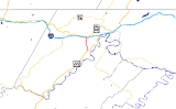
Maryland Route 53 is a state highway
in the U.S. state
of Maryland
. Known as Winchester Road, the state highway runs 3.33 miles (5.4 km) from U.S. Route 220
(US 220) in Cresaptown
north to US 40 Alternate in La Vale
. MD 53 is part of US 220 Truck, which provides access from Interstate 68
(I-68) west of La Vale to US 220 south for trucks due to a truck prohibition on the eastbound exit ramp for I-68's interchange with US 220. The state highway is also a part of the National Highway System
from US 220 to I-68. MD 53 is the northernmost part of the Winchester Road, a colonial era road between Cumberland
and Winchester, Virginia
. The modern MD 53 was constructed in the mid 1920s and updated in the 1950s.
. MD 53 heads north as a one-way street headed southbound. The state highway becomes two-way at its intersection with Brant Road, which joins the one-way street southbound. MD 53 receives northbound traffic from US 220 via MD 636 (Warrior Drive). Southbound traffic approaching the intersection of MD 53 and MD 636 may use either state highway to access both directions of US 220.
MD 53 continues north from MD 636 as a two-lane road that crosses Warrior Run. MD 53 continues north along the western flank of Haystack Mountain
, crossing Winchester Run a few times and intersecting both ends of MD 951 (Vine Street), the old alignment of MD 53. The state highway expands to a four-lane divided highway as it passes to the west of Country Club Mall
. After an intersection with MD 658
(Vocke Road), MD 53 turns northwest and passes under I-68 (National Freeway), with the only direct access an entrance to eastbound I-68. The state highway then meets its northern terminus at an intersection with US 40 Alternate in La Vale. Access to westbound I-68 is provided a short distance to the east on US 40 Alternate.
at Pinto
, crossed Knobly Mountain
to reach the path of West Virginia Route 28, which it followed to Romney
, then followed the path of US 50
east to Winchester. Winchester Road south of Cresaptown was never a state highway, but it was upgraded as a military access road to the United States Army
's Allegany Ordnance Plant (now the Allegany Ballistics Laboratory
) in West Virginia
on the opposite side of the Potomac River from Pinto during World War II. The county highway remained the primary access point to the laboratory from Maryland until the construction of MD 956
in 1967.
The modern MD 53 was constructed between 1924 and 1926. MD 53 was rebuilt between 1953 and 1956, bypassing the alignment that is now MD 951. It is not clear when the southernmost portion of MD 53 became one-way southbound. MD 53 was expanded to a divided highway from just south of MD 658 north to US 40 Alternate in 1972 in conjunction with the construction of I-68 through La Vale.
.
{| class=wikitable
!Location
!Mile
!Destinations
!Notes
|-
|rowspan=3|Cresaptown
|0.00
|
|Southern terminus; southern end of one-way street southbound
|-
|
|Brant Road
|Northern end of one-way street southbound; southbound entrance only
|-
|
|
|Northbound traffic from US 220 joins from MD 636; MD 636 is unsigned
|-
|rowspan=3|La Vale
|0
|
|US 220 Truck joins southbound from MD 658
|-
|
|
|Entrance to I-68 east only
|-
|3.33
|
|Northern terminus
State highway
State highway, state road or state route can refer to one of three related concepts, two of them related to a state or provincial government in a country that is divided into states or provinces :#A...
in the U.S. state
U.S. state
A U.S. state is any one of the 50 federated states of the United States of America that share sovereignty with the federal government. Because of this shared sovereignty, an American is a citizen both of the federal entity and of his or her state of domicile. Four states use the official title of...
of Maryland
Maryland
Maryland is a U.S. state located in the Mid Atlantic region of the United States, bordering Virginia, West Virginia, and the District of Columbia to its south and west; Pennsylvania to its north; and Delaware to its east...
. Known as Winchester Road, the state highway runs 3.33 miles (5.4 km) from U.S. Route 220
U.S. Route 220 in Maryland
U.S. Route 220 is a part in the U.S. Highway System that runs from Rockingham, North Carolina to Waverly, New York. In Maryland, the federal highway runs from the West Virginia state line at the Potomac River in McCoole north to the Pennsylvania state line in Dickens...
(US 220) in Cresaptown
Cresaptown, Maryland
Cresaptown is a community located in Allegany County, Maryland, United States of America. It is an unincorporated community which, for United States Census Bureau purposes, is united with Bel Air to form the census-designated place of Cresaptown-Bel Air. Cresaptown's post office was established...
north to US 40 Alternate in La Vale
La Vale, Maryland
La Vale is a census-designated place in Allegany County, Maryland, United States. It is part of the 'Cumberland, MD-WV Metropolitan Statistical Area'...
. MD 53 is part of US 220 Truck, which provides access from Interstate 68
Interstate 68
Interstate 68 is a Interstate highway in the U.S. states of West Virginia and Maryland, connecting in Morgantown to in Hancock. is also Corridor E of the Appalachian Development Highway System. From 1965 until the freeway's construction was completed in 1991, it was designated as...
(I-68) west of La Vale to US 220 south for trucks due to a truck prohibition on the eastbound exit ramp for I-68's interchange with US 220. The state highway is also a part of the National Highway System
National Highway System (United States)
The National Highway System is a network of strategic highways within the United States, including the Interstate Highway System and other roads serving major airports, ports, rail or truck terminals, railway stations, pipeline terminals and other strategic transport facilities.Individual states...
from US 220 to I-68. MD 53 is the northernmost part of the Winchester Road, a colonial era road between Cumberland
Cumberland, Maryland
Cumberland is a city in the far western, Appalachian portion of Maryland, United States. It is the county seat of Allegany County, and the primary city of the Cumberland, MD-WV Metropolitan Statistical Area. At the 2010 census, the city had a population of 20,859, and the metropolitan area had a...
and Winchester, Virginia
Winchester, Virginia
Winchester is an independent city located in the northwestern portion of the Commonwealth of Virginia in the USA. The city's population was 26,203 according to the 2010 Census...
. The modern MD 53 was constructed in the mid 1920s and updated in the 1950s.
Route description
MD 53 begins at an intersection with US 220 (McMullen Highway) in Cresaptown. Winchester Road continues south as a county-maintained highway toward PintoPinto, Maryland
Pinto is an unincorporated community along the North Branch Potomac River in Allegany County, Maryland across from Rocket Center, West Virginia. While the town is officially named Potomac, its post office is referred to as Pinto because there already exists a Potomac, Maryland. Pinto is located...
. MD 53 heads north as a one-way street headed southbound. The state highway becomes two-way at its intersection with Brant Road, which joins the one-way street southbound. MD 53 receives northbound traffic from US 220 via MD 636 (Warrior Drive). Southbound traffic approaching the intersection of MD 53 and MD 636 may use either state highway to access both directions of US 220.
MD 53 continues north from MD 636 as a two-lane road that crosses Warrior Run. MD 53 continues north along the western flank of Haystack Mountain
Haystack Mountain (Maryland)
Haystack Mountain is a mountain ridge in the Ridge and Valley region of the Appalachian Mountains, located in western Maryland just west of the city of Cumberland...
, crossing Winchester Run a few times and intersecting both ends of MD 951 (Vine Street), the old alignment of MD 53. The state highway expands to a four-lane divided highway as it passes to the west of Country Club Mall
Country Club Mall
Country Club Mall is a shopping mall located in La Vale, Maryland, a suburb of Cumberland, Maryland in Allegany County, Maryland. The mall has 47 retail units, as well as 5 vendor stands on the main concourse. The largest retailers in the mall are Wal-Mart, the Bon-Ton, Sears, and JCPenney...
. After an intersection with MD 658
Maryland Route 658
Maryland Route 658 is an unsigned state highway in the U.S. state of Maryland. The state highway runs from MD 53 north to U.S. Route 40 Alternate within La Vale...
(Vocke Road), MD 53 turns northwest and passes under I-68 (National Freeway), with the only direct access an entrance to eastbound I-68. The state highway then meets its northern terminus at an intersection with US 40 Alternate in La Vale. Access to westbound I-68 is provided a short distance to the east on US 40 Alternate.
History
The Winchester Road was first laid out in the 18th century as the route from Cumberland to Winchester, Virginia. The route headed south from near the present intersection of US 40 Alternate and MD 53 to Cresaptown, continued south to a crossing of the Potomac RiverPotomac River
The Potomac River flows into the Chesapeake Bay, located along the mid-Atlantic coast of the United States. The river is approximately long, with a drainage area of about 14,700 square miles...
at Pinto
Pinto, Maryland
Pinto is an unincorporated community along the North Branch Potomac River in Allegany County, Maryland across from Rocket Center, West Virginia. While the town is officially named Potomac, its post office is referred to as Pinto because there already exists a Potomac, Maryland. Pinto is located...
, crossed Knobly Mountain
Knobly Mountain
Knobly Mountain is a part of the Ridge-and-Valley Appalachians, located east of New Creek Mountain in Mineral and Grant counties, West Virginia, in the United States....
to reach the path of West Virginia Route 28, which it followed to Romney
Romney, West Virginia
Romney is a city in and the county seat of Hampshire County, West Virginia, United States. The population was 1,940 at the 2000 census, while the area covered by the city's ZIP code had a population of 5,873. It is a city with a very historic background dating back to the 18th century...
, then followed the path of US 50
U.S. Route 50
U.S. Route 50 is a major east–west route of the U.S. Highway system, stretching just over from Ocean City, Maryland on the Atlantic Ocean to West Sacramento, California. Until 1972, when it was replaced by Interstate Highways west of the Sacramento area, it extended to San Francisco, near...
east to Winchester. Winchester Road south of Cresaptown was never a state highway, but it was upgraded as a military access road to the United States Army
United States Army
The United States Army is the main branch of the United States Armed Forces responsible for land-based military operations. It is the largest and oldest established branch of the U.S. military, and is one of seven U.S. uniformed services...
's Allegany Ordnance Plant (now the Allegany Ballistics Laboratory
Allegany Ballistics Laboratory
Allegany Ballistics Laboratory located in Rocket Center, West Virginia, is a diverse industrial complex employing some 1,000 people across...
) in West Virginia
West Virginia
West Virginia is a state in the Appalachian and Southeastern regions of the United States, bordered by Virginia to the southeast, Kentucky to the southwest, Ohio to the northwest, Pennsylvania to the northeast and Maryland to the east...
on the opposite side of the Potomac River from Pinto during World War II. The county highway remained the primary access point to the laboratory from Maryland until the construction of MD 956
Maryland Route 956
Maryland Route 956 is a state highway in the U.S. state of Maryland. Known as Patriot Parkway. the state highway runs from U.S. Route 220 in Pinto east to the West Virginia state line at the Potomac River, where the highway continues as West Virginia Route 956 in Rocket Center...
in 1967.
The modern MD 53 was constructed between 1924 and 1926. MD 53 was rebuilt between 1953 and 1956, bypassing the alignment that is now MD 951. It is not clear when the southernmost portion of MD 53 became one-way southbound. MD 53 was expanded to a divided highway from just south of MD 658 north to US 40 Alternate in 1972 in conjunction with the construction of I-68 through La Vale.
Junction list
The entire route is in Allegany CountyAllegany County, Maryland
Allegany County is a county located in the northwestern part of the US state of Maryland. It is part of the Cumberland, MD-WV Metropolitan Statistical Area. As of 2010, the population was 75,087. Its county seat is Cumberland...
.
{| class=wikitable
!Location
!Mile
!Destinations
!Notes
|-
|rowspan=3|Cresaptown
Cresaptown, Maryland
Cresaptown is a community located in Allegany County, Maryland, United States of America. It is an unincorporated community which, for United States Census Bureau purposes, is united with Bel Air to form the census-designated place of Cresaptown-Bel Air. Cresaptown's post office was established...
|0.00
|
|Southern terminus; southern end of one-way street southbound
|-
|
|Brant Road
|Northern end of one-way street southbound; southbound entrance only
|-
|
|
|Northbound traffic from US 220 joins from MD 636; MD 636 is unsigned
|-
|rowspan=3|La Vale
La Vale, Maryland
La Vale is a census-designated place in Allegany County, Maryland, United States. It is part of the 'Cumberland, MD-WV Metropolitan Statistical Area'...
|0
|
|US 220 Truck joins southbound from MD 658
|-
|
|
|Entrance to I-68 east only
|-
|3.33
|
|Northern terminus