
Interstate 74
Encyclopedia
Interstate 74 is an Interstate Highway in the Midwestern and Southeastern United States
. Its western end is at an intersection with Interstate 80
in Davenport, Iowa
; the eastern end of its Midwest segment is at an intersection with Interstate 75
in Cincinnati, Ohio
. It also exists as several other disconnected sections of highways in North Carolina
(see details
); also see List of gaps in Interstate Highways.
Interstate 74 is the only interstate to overlap with a US Route sharing the same numerical identification, which it does with U.S. Route 74 in North Carolina. Such is a rare phenomenon because interstates and US routes are numbered in order from opposite ends of the country, and in middle sections, such overlap is avoided.
|IA
|| 5.36 || 8.63
|-
|IL
|| 220.34 || 354.60
|-
|IN
|| 171.54 || 276.07
|-
|OH || 19.47 || 31.33
|-
|WV || ||
|-
|VA ||
|-
|NC
|| 75.10 || 125.25
|-
|SC || ||
|-
|Total || 491.81 || 828.38
|}
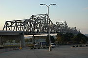
, Interstate 74 runs south from Interstate 80
for 5.36 miles (8.6 km) before crossing into Illinois on the Interstate 74 Bridge. North of the Mississippi River
, I-74 bisects Bettendorf
and Davenport
.
, Interstate 74 runs south from Moline
to Galesburg
; from this point it runs southeast through Peoria
to the Bloomington-Normal
area and Interstate 55
. I-74 continues southeast to the Champaign-Urbana area, intersecting with Interstate 57
. The interstate then runs east past Danville
at the Illinois-Indiana state line. U.S. Route 150
parallels Interstate 74 in Illinois for its entire length, save the last few miles on the eastern end (in Danville, when US 150 turns south on Illinois 1), where it parallels U.S. Route 136
.
, Interstate 74 runs east from the Illinois state line to the Crawfordsville
area before turning southeast. It then runs around the city center of Indianapolis
along Interstate 465
. It then enters Ohio in Harrison, Ohio.
, Interstate 74 runs southeast from the Indiana border to the western segment's current eastern terminus at Interstate 75
just north of downtown Cincinnati. It is also signed with U.S. Route 52
for its entire length.
. It is to be routed mostly along the current path of US 52, known as the Tolsia Highway. WVDOT is currently upgrading the Tolsia Highway to four lanes, but not to Interstate Highway standards.
through the state of Virginia
, but remains unsigned from the West Virginia border to the North Carolina border.
, as of the end of 2008 I-74 exists in several segments. This includes the most western portion of Interstate 74 which runs from Interstate 77
to US 52 just south of Mount Airy
, again as the southern segment of Interstate 73
and U.S. Route 220
from just north of Asheboro
to south of Candor
, and finally a more eastern segment that runs from Laurinburg
to an end at NC 41 near Lumberton
. A fourth segment, co-signed as US 311, opened to traffic as the High Point bypass in November 2010; it includes an interchange with I-85 and extends approximately 3 miles east of that freeway; it is signed as I-74/US 311. An adjacent section of extant US 311 freeway west from High Point to I-40 east of Winston-Salem remains unsigned due to several substandard features—although it includes signage declaring it as a "future I-74 corridor".
(along current U.S. Route 52
) to I-77. It would then follow I-77 through Virginia
into North Carolina where it would connect to highways already signed as I-74. In 1996 AASHTO approved the signing of highways as I-74 along its proposed path east (south) of I-81 in Wytheville, Virginia
, where those highways meet Interstate Highway standards. North Carolina started putting up I-74 signs along its roadways in 1997.
Two sections of I-74 in North Carolina are currently under construction and one section was just completed. The completed one is the U.S. 74 freeway from the end of the Laurinburg–Maxton Bypass across Interstate 95
to NC 41 (19 miles) completed by the end of September 2008, though a 6 miles (9.7 km) section from Maxton to NC 710 opened earlier on November 30, 2007. With this opening I-74 signage was extended 13 miles (20.9 km) east along the Laurinburg and Maxton bypasses. The two 4 miles (6.4 km) segments under construction are the U.S. 311 Bypass of High Point, North Carolina
, which also will carry I-74 from Business Loop 85 to Interstate 85, started construction in May 2007. The same contract started work on the first 6 miles (9.7 km) of the I-74 freeway between I-85 and U.S. 220 (Future I-73), both projects should be complete by 2011. The second segment started construction of the rest of the US 311 route to US 220 in September 2008. The proposed path of I-74 east of I-95 is farther along US 74 to NC 211 near Bolton then south along US 17
to near the South Carolina
border. These sections are not currently proposed to be built perhaps for another 20 to 30 years. The N.C. Turnpike Authority–at the request of officials in Brunswick County–are studying whether a toll road could get the section of I-74 in that county built faster.
On February 11, 2005, the North
and South Carolina Departments of Transportation
came to an agreement over where I-74 (and I-73) would cross the border between the two states. It was decided that I-74 would cross the line as a northern extension of the S.C. Highway 31. I-74 is then proposed to end south of Myrtle Beach at U.S. Route 17
. A spur route, which is expected to be called I-274, is proposed as designation for the yet-to be-constructed western half of the Winston-Salem Northern Beltway (I-74 will run on the to-be-built eastern half, construction has not been funded and won't start until at least 2015).
Starting around Laurinburg and Maxton
and to the east, the new I-74 runs concurrent with US 74. This is the first time that a U.S. and Interstate Highway with the same number have been designated on the same highway.
; while Kentucky officials want the road to begin in the west as part of a greater Cincinnati / Northern Kentucky bypass, then running along the AA Highway from near Brooksville, Kentucky
, until it joins I-64 near Ashland, Kentucky
.
United States
The United States of America is a federal constitutional republic comprising fifty states and a federal district...
. Its western end is at an intersection with Interstate 80
Interstate 80
Interstate 80 is the second-longest Interstate Highway in the United States, following Interstate 90. It is a transcontinental artery running from downtown San Francisco, California to Teaneck, New Jersey in the New York City Metropolitan Area...
in Davenport, Iowa
Davenport, Iowa
Davenport is a city located along the Mississippi River in Scott County, Iowa, United States. Davenport is the county seat of and largest city in Scott County. Davenport was founded on May 14, 1836 by Antoine LeClaire and was named for his friend, George Davenport, a colonel during the Black Hawk...
; the eastern end of its Midwest segment is at an intersection with Interstate 75
Interstate 75
Interstate 75 is a major north–south Interstate Highway in the Great Lakes and Southeastern regions of the United States. It travels from State Road 826 and State Road 924 in Hialeah, Florida to Sault Ste. Marie, Michigan, at the Ontario, Canada, border...
in Cincinnati, Ohio
Cincinnati, Ohio
Cincinnati is a city in the U.S. state of Ohio. Cincinnati is the county seat of Hamilton County. Settled in 1788, the city is located to north of the Ohio River at the Ohio-Kentucky border, near Indiana. The population within city limits is 296,943 according to the 2010 census, making it Ohio's...
. It also exists as several other disconnected sections of highways in North Carolina
North Carolina
North Carolina is a state located in the southeastern United States. The state borders South Carolina and Georgia to the south, Tennessee to the west and Virginia to the north. North Carolina contains 100 counties. Its capital is Raleigh, and its largest city is Charlotte...
(see details
Interstate 74 in North Carolina
In the U.S. state of North Carolina, Interstate 74 is an Interstate Highway that is partially completed. Currently in four distinct segments in the state; when completed, it will traverse in a southeasterly direction from Virginia to South Carolina, connecting the cities of Winston-Salem, High...
); also see List of gaps in Interstate Highways.
Interstate 74 is the only interstate to overlap with a US Route sharing the same numerical identification, which it does with U.S. Route 74 in North Carolina. Such is a rare phenomenon because interstates and US routes are numbered in order from opposite ends of the country, and in middle sections, such overlap is avoided.
Route description
|-|IA
Interstate 74 in Iowa
Interstate 74 is the central freeway through the Iowa Quad Cities. It roughly divides Davenport to the west and Bettendorf to the east. The Interstate Highway begins at an interchange with Interstate 80 at the northeastern edge of Davenport and continues into Illinois at the Mississippi River...
|| 5.36 || 8.63
|-
|IL
Interstate 74 in Illinois
In the U.S. state of Illinois, Interstate 74 is a major northwest-southeast Interstate Highway that runs across the northern portion of the state. It runs from the Iowa state line at the Mississippi River southeast to the Indiana state line east of Danville, Illinois. This is a distance of 220.34...
|| 220.34 || 354.60
|-
|IN
Interstate 74 in Indiana
In the U.S. state of Indiana, Interstate 74 traverses central parts of the state from west to east. It connects Champaign in Illinois with Indianapolis in the center of the state, and Indianapolis with Cincinnati in Ohio...
|| 171.54 || 276.07
|-
|OH || 19.47 || 31.33
|-
|WV || ||
|-
|VA ||
|-
|NC
Interstate 74 in North Carolina
In the U.S. state of North Carolina, Interstate 74 is an Interstate Highway that is partially completed. Currently in four distinct segments in the state; when completed, it will traverse in a southeasterly direction from Virginia to South Carolina, connecting the cities of Winston-Salem, High...
|| 75.10 || 125.25
|-
|SC || ||
|-
|Total || 491.81 || 828.38
|}
Iowa
In the state of IowaIowa
Iowa is a state located in the Midwestern United States, an area often referred to as the "American Heartland". It derives its name from the Ioway people, one of the many American Indian tribes that occupied the state at the time of European exploration. Iowa was a part of the French colony of New...
, Interstate 74 runs south from Interstate 80
Interstate 80
Interstate 80 is the second-longest Interstate Highway in the United States, following Interstate 90. It is a transcontinental artery running from downtown San Francisco, California to Teaneck, New Jersey in the New York City Metropolitan Area...
for 5.36 miles (8.6 km) before crossing into Illinois on the Interstate 74 Bridge. North of the Mississippi River
Mississippi River
The Mississippi River is the largest river system in North America. Flowing entirely in the United States, this river rises in western Minnesota and meanders slowly southwards for to the Mississippi River Delta at the Gulf of Mexico. With its many tributaries, the Mississippi's watershed drains...
, I-74 bisects Bettendorf
Bettendorf, Iowa
Bettendorf is a city in Scott County, Iowa, United States. Bettendorf is the fifteenth largest city in the U.S. state of Iowa and the fourth largest city in the "Quad Cities". As of the 2010 United States Census the population grew to 33,217. Bettendorf is one of the Quad Cities, along with...
and Davenport
Davenport, Iowa
Davenport is a city located along the Mississippi River in Scott County, Iowa, United States. Davenport is the county seat of and largest city in Scott County. Davenport was founded on May 14, 1836 by Antoine LeClaire and was named for his friend, George Davenport, a colonel during the Black Hawk...
.
Illinois
In the state of IllinoisIllinois
Illinois is the fifth-most populous state of the United States of America, and is often noted for being a microcosm of the entire country. With Chicago in the northeast, small industrial cities and great agricultural productivity in central and northern Illinois, and natural resources like coal,...
, Interstate 74 runs south from Moline
Moline, Illinois
Moline is a city located in Rock Island County, Illinois, United States, with a population of 45,792 in 2010. Moline is one of the Quad Cities, along with neighboring East Moline and Rock Island in Illinois and the cities of Davenport and Bettendorf in Iowa. The Quad Cities has a population of...
to Galesburg
Galesburg, Illinois
Galesburg is a city in Knox County, Illinois, in the United States. As of the 2010 census, the city population was 32,195. It is the county seat of Knox County....
; from this point it runs southeast through Peoria
Peoria, Illinois
Peoria is the largest city on the Illinois River and the county seat of Peoria County, Illinois, in the United States. It is named after the Peoria tribe. As of the 2010 census, the city was the seventh-most populated in Illinois, with a population of 115,007, and is the third-most populated...
to the Bloomington-Normal
Bloomington-Normal, Illinois
Bloomington-Normal refers to the twin municipalities of Bloomington and Normal in McLean County, in Central Illinois. The combined population of the two communities in a special census in 2006 was 125,000.-Sports:...
area and Interstate 55
Interstate 55
Interstate 55 is an Interstate Highway in the central United States. Its odd number indicates that it is a north–south Interstate Highway. I-55 goes from LaPlace, Louisiana at Interstate 10 to Chicago at U.S. Route 41 , at McCormick Place. A common nickname for the highway is "double...
. I-74 continues southeast to the Champaign-Urbana area, intersecting with Interstate 57
Interstate 57
Interstate 57 is an Interstate Highway in Missouri and Illinois that parallels the old Illinois Central rail line for much of its route. It goes from Miner, Missouri, at Interstate 55 to Chicago, Illinois, at Interstate 94. I-57 essentially serves as a shortcut route for travelers headed between...
. The interstate then runs east past Danville
Danville, Illinois
Danville is a city in Vermilion County, Illinois, United States. It is the principal city of the'Danville, Illinois Metropolitan Statistical Area' which encompasses all of Danville and Vermilion County. As of the 2010 census, the city had a total population of 32,467. It is the county seat of...
at the Illinois-Indiana state line. U.S. Route 150
U.S. Route 150
U.S. Route 150 is a 571 mile long northwest-southeast United States highway, signed as east–west. It runs from U.S. Route 6 outside of Moline, Illinois to U.S. Route 25 in Mount Vernon, Kentucky .-Illinois:In the state of Illinois, U.S. 150 runs from the Quad City International Airport at U.S...
parallels Interstate 74 in Illinois for its entire length, save the last few miles on the eastern end (in Danville, when US 150 turns south on Illinois 1), where it parallels U.S. Route 136
U.S. Route 136
U.S. Highway 136 is a spur of U.S. Highway 36. It runs from Edison, Nebraska, at U.S. Highway 6 and U.S. Highway 34 to the Interstate 74/Interstate 465 interchange in Speedway, Indiana. This is a distance of 804 miles .-Nebraska:...
.
Indiana
In the state of IndianaIndiana
Indiana is a US state, admitted to the United States as the 19th on December 11, 1816. It is located in the Midwestern United States and Great Lakes Region. With 6,483,802 residents, the state is ranked 15th in population and 16th in population density. Indiana is ranked 38th in land area and is...
, Interstate 74 runs east from the Illinois state line to the Crawfordsville
Crawfordsville, Indiana
Crawfordsville is a city in Union Township, Montgomery County, Indiana, United States. As of the 2010 census, the city had a population of 15,915. The city is the county seat of Montgomery County...
area before turning southeast. It then runs around the city center of Indianapolis
Indianapolis, Indiana
Indianapolis is the capital of the U.S. state of Indiana, and the county seat of Marion County, Indiana. As of the 2010 United States Census, the city's population is 839,489. It is by far Indiana's largest city and, as of the 2010 U.S...
along Interstate 465
Interstate 465
Interstate 465 , also known as the USS Indianapolis Memorial Highway, is the beltway circling Indianapolis, Indiana, United States. It is roughly rectangular in shape and has a perimeter of approximately 53 miles . It lies almost completely within the boundaries of Marion County, except for two...
. It then enters Ohio in Harrison, Ohio.
Ohio
In the state of OhioOhio
Ohio is a Midwestern state in the United States. The 34th largest state by area in the U.S.,it is the 7th‑most populous with over 11.5 million residents, containing several major American cities and seven metropolitan areas with populations of 500,000 or more.The state's capital is Columbus...
, Interstate 74 runs southeast from the Indiana border to the western segment's current eastern terminus at Interstate 75
Interstate 75
Interstate 75 is a major north–south Interstate Highway in the Great Lakes and Southeastern regions of the United States. It travels from State Road 826 and State Road 924 in Hialeah, Florida to Sault Ste. Marie, Michigan, at the Ontario, Canada, border...
just north of downtown Cincinnati. It is also signed with U.S. Route 52
U.S. Route 52
U.S. Route 52 is a United States highway that runs across the northern, eastern and southeastern regions of the United States. Contrary to most other even-numbered U.S...
for its entire length.
West Virginia
As of October 2009, Interstate 74 remains unbuilt in the state of West VirginiaWest Virginia
West Virginia is a state in the Appalachian and Southeastern regions of the United States, bordered by Virginia to the southeast, Kentucky to the southwest, Ohio to the northwest, Pennsylvania to the northeast and Maryland to the east...
. It is to be routed mostly along the current path of US 52, known as the Tolsia Highway. WVDOT is currently upgrading the Tolsia Highway to four lanes, but not to Interstate Highway standards.
Virginia
As of December 2008, Interstate 74 is proposed to follow the path of Interstate 77Interstate 77
Interstate 77 is an Interstate Highway in the eastern United States. It traverses diverse terrain, from the mountainous state of West Virginia to the rolling farmlands of North Carolina and Ohio. It largely supplants the old U.S...
through the state of Virginia
Virginia
The Commonwealth of Virginia , is a U.S. state on the Atlantic Coast of the Southern United States. Virginia is nicknamed the "Old Dominion" and sometimes the "Mother of Presidents" after the eight U.S. presidents born there...
, but remains unsigned from the West Virginia border to the North Carolina border.
North Carolina
In the state of North CarolinaNorth Carolina
North Carolina is a state located in the southeastern United States. The state borders South Carolina and Georgia to the south, Tennessee to the west and Virginia to the north. North Carolina contains 100 counties. Its capital is Raleigh, and its largest city is Charlotte...
, as of the end of 2008 I-74 exists in several segments. This includes the most western portion of Interstate 74 which runs from Interstate 77
Interstate 77
Interstate 77 is an Interstate Highway in the eastern United States. It traverses diverse terrain, from the mountainous state of West Virginia to the rolling farmlands of North Carolina and Ohio. It largely supplants the old U.S...
to US 52 just south of Mount Airy
Mount Airy, North Carolina
Mount Airy is a city in Surry County, North Carolina, United States. As of the 2010 census, the city population was 10,388.-History:Mount Airy was settled in the 1750s as a stagecoach stop on the road between Winston-Salem and Galax, Virginia. It was named for a nearby plantation...
, again as the southern segment of Interstate 73
Interstate 73
Interstate 73 is a main route of the Interstate Highway System, currently located entirely within the U.S. state of North Carolina. It is part of a longer planned corridor, defined by various Federal laws to run from Myrtle Beach, South Carolina, to Grayling, Michigan, but only the part south of...
and U.S. Route 220
U.S. Route 220
U.S. Route 220 is a long U.S. Route in the eastern United States.US 220 is a spur route of U.S. Route 20 but at present, the two routes do not intersect nor do they connect via other spurs of US 20. The former U. S. Route 120, which was signed in Pennsylvania between 1926 and 1967, intersected...
from just north of Asheboro
Asheboro, North Carolina
Asheboro is a city in Randolph County, North Carolina, United States. The population was 21,672 at the 2000 census. It is the county seat of Randolph County, and is the home of the state-owned North Carolina Zoo.-Geography:...
to south of Candor
Candor, North Carolina
Candor is a town in Montgomery County, North Carolina, United States. The population was 825 at the 2000 census. Candor is the home of the North Carolina Peach Festival, which is held every year on the third Saturday of July. The town's welcome sign reads: Welcome to Candor...
, and finally a more eastern segment that runs from Laurinburg
Laurinburg, North Carolina
Laurinburg is a mid-sized city in Scotland County, North Carolina, United States. It is the county seat of Scotland County. Located in southern North Carolina near the South Carolina state border, Laurinburg is southwest of Fayetteville and is home to St. Andrews Presbyterian College...
to an end at NC 41 near Lumberton
Lumberton, North Carolina
Lumberton is a city in Robeson County, North Carolina, United States. The population was 20,795 at the 2000 census. It is the county seat of Robeson County. Lumberton, located in southern North Carolina's Inner Banks region, is located on the Lumber River...
. A fourth segment, co-signed as US 311, opened to traffic as the High Point bypass in November 2010; it includes an interchange with I-85 and extends approximately 3 miles east of that freeway; it is signed as I-74/US 311. An adjacent section of extant US 311 freeway west from High Point to I-40 east of Winston-Salem remains unsigned due to several substandard features—although it includes signage declaring it as a "future I-74 corridor".
South Carolina
From the North Carolina border, I-74 will follow the Carolina Bay Highway (currently signed as SC 31) around Myrtle Beach.Southeast Extension
Long-range plans call for I-74 to continue east and south of Cincinnati to North Carolina using OH 32 from Cincinnati to Piketon, Ohio, and then the proposed I-73 from Portsmouth (OH) through West VirginiaWest Virginia
West Virginia is a state in the Appalachian and Southeastern regions of the United States, bordered by Virginia to the southeast, Kentucky to the southwest, Ohio to the northwest, Pennsylvania to the northeast and Maryland to the east...
(along current U.S. Route 52
U.S. Route 52
U.S. Route 52 is a United States highway that runs across the northern, eastern and southeastern regions of the United States. Contrary to most other even-numbered U.S...
) to I-77. It would then follow I-77 through Virginia
Virginia
The Commonwealth of Virginia , is a U.S. state on the Atlantic Coast of the Southern United States. Virginia is nicknamed the "Old Dominion" and sometimes the "Mother of Presidents" after the eight U.S. presidents born there...
into North Carolina where it would connect to highways already signed as I-74. In 1996 AASHTO approved the signing of highways as I-74 along its proposed path east (south) of I-81 in Wytheville, Virginia
Wytheville, Virginia
Wytheville is a town in Wythe County, Virginia, United States. The population was 8,211 at the 2010 census. It is the county seat of Wythe County. The town is home to a Chautauqua Festival, held the third weekend in June every year since 1985...
, where those highways meet Interstate Highway standards. North Carolina started putting up I-74 signs along its roadways in 1997.
Two sections of I-74 in North Carolina are currently under construction and one section was just completed. The completed one is the U.S. 74 freeway from the end of the Laurinburg–Maxton Bypass across Interstate 95
Interstate 95 in North Carolina
Interstate 95 is a major Interstate Highway, running along the East Coast of the United States from Florida to Maine. In North Carolina, I-95 runs diagonally across the eastern third of the state, from Rowland in the southwest to Roanoke Rapids in the northeast of the Inner Banks.-Route...
to NC 41 (19 miles) completed by the end of September 2008, though a 6 miles (9.7 km) section from Maxton to NC 710 opened earlier on November 30, 2007. With this opening I-74 signage was extended 13 miles (20.9 km) east along the Laurinburg and Maxton bypasses. The two 4 miles (6.4 km) segments under construction are the U.S. 311 Bypass of High Point, North Carolina
High Point, North Carolina
High Point is a city located in the Piedmont Triad region of North Carolina. As of 2010 the city had a total population of 104,371, according to the US Census Bureau. High Point is currently the eighth-largest municipality in North Carolina....
, which also will carry I-74 from Business Loop 85 to Interstate 85, started construction in May 2007. The same contract started work on the first 6 miles (9.7 km) of the I-74 freeway between I-85 and U.S. 220 (Future I-73), both projects should be complete by 2011. The second segment started construction of the rest of the US 311 route to US 220 in September 2008. The proposed path of I-74 east of I-95 is farther along US 74 to NC 211 near Bolton then south along US 17
U.S. Route 17
U.S. Route 17 or U.S. Highway 17 is a north–south United States highway. The highway spans the southeastern United States and is close to the Atlantic Coast for much of its length. The highway's southern terminus is at Punta Gorda, Florida, at an intersection with U.S. Route 41...
to near the South Carolina
South Carolina
South Carolina is a state in the Deep South of the United States that borders Georgia to the south, North Carolina to the north, and the Atlantic Ocean to the east. Originally part of the Province of Carolina, the Province of South Carolina was one of the 13 colonies that declared independence...
border. These sections are not currently proposed to be built perhaps for another 20 to 30 years. The N.C. Turnpike Authority–at the request of officials in Brunswick County–are studying whether a toll road could get the section of I-74 in that county built faster.
On February 11, 2005, the North
North Carolina Department of Transportation
The North Carolina Department of Transportation is responsible for building, repairing, and operating highways, bridges, and other modes of transportation, including ferries in the U.S. state of North Carolina.-History:...
and South Carolina Departments of Transportation
South Carolina Department of Transportation
The South Carolina Department of Transportation is a government agency in the US state of South Carolina. Its mission is to build and maintain roads and bridges and administer mass transit services....
came to an agreement over where I-74 (and I-73) would cross the border between the two states. It was decided that I-74 would cross the line as a northern extension of the S.C. Highway 31. I-74 is then proposed to end south of Myrtle Beach at U.S. Route 17
U.S. Route 17
U.S. Route 17 or U.S. Highway 17 is a north–south United States highway. The highway spans the southeastern United States and is close to the Atlantic Coast for much of its length. The highway's southern terminus is at Punta Gorda, Florida, at an intersection with U.S. Route 41...
. A spur route, which is expected to be called I-274, is proposed as designation for the yet-to be-constructed western half of the Winston-Salem Northern Beltway (I-74 will run on the to-be-built eastern half, construction has not been funded and won't start until at least 2015).
Starting around Laurinburg and Maxton
Maxton, North Carolina
Maxton is a town in Robeson County and Scotland County Counties, North Carolina, in the United States. The population was 2,551 at the time of the 2000 U.S. Census.-History:...
and to the east, the new I-74 runs concurrent with US 74. This is the first time that a U.S. and Interstate Highway with the same number have been designated on the same highway.
Midwest extension
There is still some dispute over which routes will connect the existing stretches of I-74. Ohio has proposed that the stretch should run through the city of Cincinnati and from there either along State Route 32 or U.S. Route 52U.S. Route 52
U.S. Route 52 is a United States highway that runs across the northern, eastern and southeastern regions of the United States. Contrary to most other even-numbered U.S...
; while Kentucky officials want the road to begin in the west as part of a greater Cincinnati / Northern Kentucky bypass, then running along the AA Highway from near Brooksville, Kentucky
Brooksville, Kentucky
Brooksville is a city in Bracken County, Kentucky, in the United States. As of the 2000 census, the city's population was 589. It is the county seat of Bracken County....
, until it joins I-64 near Ashland, Kentucky
Ashland, Kentucky
Ashland, formerly known as Poage Settlement, is a city in Boyd County, Kentucky, United States, nestled along the banks of the Ohio River. The population was 21,981 at the 2000 census. Ashland is a part of the Huntington-Ashland, WV-KY-OH, Metropolitan Statistical Area . As of the 2000 census, the...
.
Major intersections
.svg.png) Interstate 80Interstate 80 in IowaIn the U.S. state of Iowa, Interstate 80 runs east–west between the Omaha-Council Bluffs area and the Quad Cities area, serving Des Moines and Iowa City. It was built along the U.S. Highway 6 corridor and as a result, three sections of Interstate 80 overlap US 6 in Iowa...
Interstate 80Interstate 80 in IowaIn the U.S. state of Iowa, Interstate 80 runs east–west between the Omaha-Council Bluffs area and the Quad Cities area, serving Des Moines and Iowa City. It was built along the U.S. Highway 6 corridor and as a result, three sections of Interstate 80 overlap US 6 in Iowa...
in Davenport, IowaDavenport, IowaDavenport is a city located along the Mississippi River in Scott County, Iowa, United States. Davenport is the county seat of and largest city in Scott County. Davenport was founded on May 14, 1836 by Antoine LeClaire and was named for his friend, George Davenport, a colonel during the Black Hawk...- Interstate 80Interstate 80 in IowaIn the U.S. state of Iowa, Interstate 80 runs east–west between the Omaha-Council Bluffs area and the Quad Cities area, serving Des Moines and Iowa City. It was built along the U.S. Highway 6 corridor and as a result, three sections of Interstate 80 overlap US 6 in Iowa...
near Colona, IllinoisColona, IllinoisColona is a city in Henry County, Illinois, along the Green River. It is part of the Quad Cities metropolitan area. The population was 5,099 at the 2010 census, down from 5,173 at the 2000 census....  Interstate 55Interstate 55 in IllinoisIn the U.S. state of Illinois, Interstate 55 is a major north–south Interstate Highway that connects the St. Louis, Missouri and Chicago metropolitan areas. It runs from the Poplar Street Bridge in East St. Louis to U.S. Route 41 near downtown Chicago...
in Bloomington, IllinoisBloomington, IllinoisBloomington is a city in McLean County, Illinois, United States and the county seat. It is adjacent to Normal, Illinois, and is the more populous of the two principal municipalities of the Bloomington-Normal metropolitan area... Interstate 57Interstate 57Interstate 57 is an Interstate Highway in Missouri and Illinois that parallels the old Illinois Central rail line for much of its route. It goes from Miner, Missouri, at Interstate 55 to Chicago, Illinois, at Interstate 94. I-57 essentially serves as a shortcut route for travelers headed between...
in Champaign, IllinoisChampaign, IllinoisChampaign is a city in Champaign County, Illinois, in the United States. The city is located south of Chicago, west of Indianapolis, Indiana, and 178 miles northeast of St. Louis, Missouri. Though surrounded by farm communities, Champaign is notable for sharing the campus of the University of... Interstate 70Interstate 70 in IndianaIn the U.S. state of Indiana, Interstate 70 travels east–west across the state passing through Indianapolis. Interstate 70 crosses into Indiana near Terre Haute and crosses into Ohio in Richmond. It covers 156.60 miles in Indiana. It parallels U.S...
in Indianapolis, IndianaIndianapolis, IndianaIndianapolis is the capital of the U.S. state of Indiana, and the county seat of Marion County, Indiana. As of the 2010 United States Census, the city's population is 839,489. It is by far Indiana's largest city and, as of the 2010 U.S... Interstate 65Interstate 65 in IndianaIn the U.S. state of Indiana, Interstate 65 traverses the state from south to north. The Indiana portion begins near Louisville, Kentucky and travels north, passing through Columbus, Indianapolis, Lafayette. Interstate 65 terminates near Gary on the Indiana Toll Road. Interstate 65 covers 261.27...
in Indianapolis, IndianaIndianapolis, IndianaIndianapolis is the capital of the U.S. state of Indiana, and the county seat of Marion County, Indiana. As of the 2010 United States Census, the city's population is 839,489. It is by far Indiana's largest city and, as of the 2010 U.S... Interstate 75Interstate 75 in OhioIn the U.S. state of Ohio, Interstate 75 runs from Cincinnati to Toledo by way of Dayton. I-75 enters Ohio concurrent with I-71 from Kentucky on the Brent Spence Bridge over the Ohio River and into the Bluegrass region...
in Cincinnati, OhioCincinnati, OhioCincinnati is a city in the U.S. state of Ohio. Cincinnati is the county seat of Hamilton County. Settled in 1788, the city is located to north of the Ohio River at the Ohio-Kentucky border, near Indiana. The population within city limits is 296,943 according to the 2010 census, making it Ohio's....svg.png) Interstate 64Interstate 64 in West VirginiaThe alignment of Interstate 64 was to originally parallel US 60 from Charleston to the Virginia state line. This would go through environmentally sensitive areas such as Hawk's Nest and the New River Gorge area and might have disrupted the natural beauty and the isolation of the area.In 1969,...
Interstate 64Interstate 64 in West VirginiaThe alignment of Interstate 64 was to originally parallel US 60 from Charleston to the Virginia state line. This would go through environmentally sensitive areas such as Hawk's Nest and the New River Gorge area and might have disrupted the natural beauty and the isolation of the area.In 1969,...
near Huntington, West VirginiaHuntington, West VirginiaHuntington is a city in Cabell and Wayne counties in the U.S. state of West Virginia, along the Ohio River. Most of the city is in Cabell County, for which it is the county seat. A small portion of the city, mainly the neighborhood of Westmoreland, is in Wayne County. Its population was 49,138 at...
(future) Interstate 81Interstate 81 in VirginiaInterstate 81 is an long highway. In the U.S. state of Virginia, I-81 runs for , making it longer in Virginia than in any other state. It stretches from the Tennessee state line near Bristol to the West Virginia state line near Winchester. U.S...
near Wytheville, VirginiaWytheville, VirginiaWytheville is a town in Wythe County, Virginia, United States. The population was 8,211 at the 2010 census. It is the county seat of Wythe County. The town is home to a Chautauqua Festival, held the third weekend in June every year since 1985...
(future) Interstate 77Interstate 77 in North CarolinaIn the U.S. state of North Carolina, Interstate 77 is a Interstate Highway, which serves the city of Charlotte and the Western Piedmont.-Route description:...
near Mount Airy, North CarolinaMount Airy, North CarolinaMount Airy is a city in Surry County, North Carolina, United States. As of the 2010 census, the city population was 10,388.-History:Mount Airy was settled in the 1750s as a stagecoach stop on the road between Winston-Salem and Galax, Virginia. It was named for a nearby plantation... Interstate 40Interstate 40 in North CarolinaInterstate 40 runs through the state of North Carolina from the Tennessee state line in the west to its eastern terminus in Wilmington.-Pigeon River Gorge:...
in Winston-Salem, North CarolinaWinston-Salem, North CarolinaWinston-Salem is a city in the U.S. state of North Carolina, with a 2010 population of 229,617. Winston-Salem is the county seat and largest city of Forsyth County and the fourth-largest city in the state. Winston-Salem is the second largest municipality in the Piedmont Triad region and is home to...
(future) Interstate 73Interstate 73Interstate 73 is a main route of the Interstate Highway System, currently located entirely within the U.S. state of North Carolina. It is part of a longer planned corridor, defined by various Federal laws to run from Myrtle Beach, South Carolina, to Grayling, Michigan, but only the part south of...
near Asheboro, North CarolinaAsheboro, North CarolinaAsheboro is a city in Randolph County, North Carolina, United States. The population was 21,672 at the 2000 census. It is the county seat of Randolph County, and is the home of the state-owned North Carolina Zoo.-Geography:...
, near Rockingham, North CarolinaRockingham, North CarolinaRockingham is a city in Richmond County, North Carolina, United States named after the Marquis of Rockingham. The population was 9,672 at the 2000 census. It is the county seat of Richmond County...
(future), near Myrtle Beach, South CarolinaMyrtle Beach, South CarolinaMyrtle Beach is a coastal city on the east coast of the United States in Horry County, South Carolina. It is situated on the center of a large and continuous stretch of beach known as the Grand Strand in northeastern South Carolina. It is considered to be a major tourist destination in the...
(future) Interstate 85Interstate 85 in North CarolinaIn the U.S. state of North Carolina, Interstate 85 scales the state for from the South Carolina border to the Virginia border. As the second-longest interstate in the state , it provides an important link between the cities of Atlanta, Georgia, Charlotte, Greensboro, Richmond, Virginia and...
near High Point, North CarolinaHigh Point, North CarolinaHigh Point is a city located in the Piedmont Triad region of North Carolina. As of 2010 the city had a total population of 104,371, according to the US Census Bureau. High Point is currently the eighth-largest municipality in North Carolina.... Interstate 95Interstate 95 in North CarolinaInterstate 95 is a major Interstate Highway, running along the East Coast of the United States from Florida to Maine. In North Carolina, I-95 runs diagonally across the eastern third of the state, from Rowland in the southwest to Roanoke Rapids in the northeast of the Inner Banks.-Route...
near Lumberton, North CarolinaLumberton, North CarolinaLumberton is a city in Robeson County, North Carolina, United States. The population was 20,795 at the 2000 census. It is the county seat of Robeson County. Lumberton, located in southern North Carolina's Inner Banks region, is located on the Lumber River...
Auxiliary routes
- Peoria, IllinoisPeoria, IllinoisPeoria is the largest city on the Illinois River and the county seat of Peoria County, Illinois, in the United States. It is named after the Peoria tribe. As of the 2010 census, the city was the seventh-most populated in Illinois, with a population of 115,007, and is the third-most populated...
- I-474Interstate 474Interstate 474 is an Interstate Highway loop route that provides a southern bypass around the north central Illinois city of Peoria. I-474's parent interstate is I-74. As the first digit of the interstate's number is even, it follows the established convention of providing a loop around a city.... - Winston-Salem, North CarolinaWinston-Salem, North CarolinaWinston-Salem is a city in the U.S. state of North Carolina, with a 2010 population of 229,617. Winston-Salem is the county seat and largest city of Forsyth County and the fourth-largest city in the state. Winston-Salem is the second largest municipality in the Piedmont Triad region and is home to...
- I-274Interstate 274In the U.S. state of North Carolina, Interstate 274 is the designation for a future beltway interstate route. When completed, it will connect US 158, near Clemmons, to Future I-74/US 52, in Bethania.-Route description:...
(planned)
See also
- I-73/74 north–south Corridor
- Interstate 73Interstate 73Interstate 73 is a main route of the Interstate Highway System, currently located entirely within the U.S. state of North Carolina. It is part of a longer planned corridor, defined by various Federal laws to run from Myrtle Beach, South Carolina, to Grayling, Michigan, but only the part south of...
- U.S. Route 74U.S. Route 74U.S. Route 74 is an east–west United States highway that runs for from Cleveland, Tennessee to Wrightsville Beach, North Carolina.-Tennessee:Established in 1987, US-74 western terminus is exit 20 on I-75 in Cleveland...
External links
- I-74 in NC Progress Page
- SCDOT - Carolina Bays Parkway Phase II (part of I-74)
- High Priority Corridor 5 (I-73/74)
- Upgrade 74 Renovation Project
- I-74 on Cincinnati-Transit.net
- Interstate 74 Cincinnati to Piketon Corridor
- I-74 Iowa-Illinois Corridor Study
- Illinois Highway Ends: Interstate 74
- Indiana Highway Ends: Interstate 74
- AA Roads - Interstate 74
- National I-73/74 Corridor Association
- Interstate 74 Construction, Moline, Illinois