
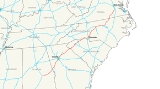
Interstate 85
Encyclopedia
Interstate 85 is a major interstate highway in the Southeastern United States
. Its current southern terminus is at an interchange with Interstate 65
in Montgomery, Alabama
; its northern terminus interchanges with Interstate 95
in Petersburg, Virginia
, near Richmond
. In its northern half it roughly parallels an ancient indian trading path documented since colonial times from Petersburg, Virginia to the Catawba
Indian territory.
An extension of Interstate 85 is proposed west from Montgomery
to interchange with Interstate 20
& Interstate 59
just east of the Mississippi
state line.
|AL
|80
|130
|-
|GA
|179.9
|292
|-
|SC
|106.28
|172
|-
|NC
|233.93
|377
|-
|VA
|68.64
|112
|-
|Total
|668.75
|1,082
|}
in Montgomery
. From here, I-85 parallels U.S. Route 80
until the highway nears Tuskegee
. At Tuskegee, I-85 leaves U.S. 80 and starts to parallel U.S. Route 29
, which the highway parallels for much of its length.
I-85 also passes near Auburn
, Opelika
, Valley
and Lanett
before crossing the Chattahoochee River
into Georgia
.
 In Georgia, Interstate 85 bypasses West Point
before coming into the LaGrange
area. East of LaGrange, I-85 intersects Interstate 185
. Travelers can take I-185 to Columbus
and Fort Benning. Travelers can also see the construction of Kia
's multi-billion dollar plant in West Point, just a few miles south west of LaGrange.
I-85 in Georgia is designated — but not signed as - State Route 403.
. Before reaching Atlanta, the highway drives through a recently widened stretch between exits 28 and 74, passing the suburbs of Newnan
, College Park
and East Point
as well as intersecting Interstate 285
and providing access to Hartsfield-Jackson Atlanta International Airport
. On the south side of the city, I-85 merges with Interstate 75
to form the Downtown Connector
. Just before downtown, the highway goes through a pile-up intersection with I-20. Afterward, the two highways go through the heart of the city until they split and cross over each other just north of Georgia Tech
. At the split, I-75 exits via the right three lanes and then heads northwest while I-85 uses the left three lanes and then heads northeast.

and Doraville
, where there is another intersection with I-285 (nicknamed Spaghetti Junction
). Also, on the section from Chamblee-Tucker Road to Old Peachtree road in Gwinnett County, the current HOV lanes presented are being considered for converting to high occupancy toll lanes to help ease the congestion which is currently present during rush hours.
Continuing northbound, drivers will see another interstate spur - Interstate 985
, which provides a link to Gainesville
- before heading through northeastern Georgia. At Lake Hartwell
- which was formed by the damming of the Savannah River
- I-85 crosses into South Carolina
.
Just northeast of the I-75/I-85 northern split, I-85 was rerouted just north of its original route in the 1990s from just northeast of the interchange to near the State Route 400 interchange. The original route is now signed State Route 13
.
Interstate 85 provides the major transportation route for the Upstate
of South Carolina
, linking together the major centers of Greenville
and Spartanburg with regional centers of importance.
and Anderson
on the way to Greenville. Beginning at Anderson, I-85 widens from four to six lanes. Near Powdersville, U.S. 29 joins I-85 and they run concurrently until they cross the Saluda River
.
and 385
. U.S. 29 splits from I-85 and joins I-185 toward downtown Greenville. I-185 recently saw a major expansion as a toll road south of the city as the Southern Connector was completed. In this section, the roadway is six to eight lanes wide, depending on the location.
Much of the Upstate's industrial, institutional, and commercial base is located along I-85, especially with regards to the growing automotive industry. The North American headquarters for Michelin
, along with BMW's
Spartanburg assembly plant
, and the new Clemson University
International Center for Automobile Research
are all visible from the road. Additional companies have major operations along this corridor, including Hubbell Lighting, Sara Lee Corporation, Hitachi
, and General Electric
. I-85 also bypasses Greenville-Spartanburg International Airport
, which serves the Greenville-Spartanburg metropolitan area.
and was approved by AASHTO on April 22, 1995.
North of Spartanburg, I-85 narrows from six lanes back to four lanes and bypasses Gaffney
. At Gaffney, motorists can see The Peachoid
, a large water tower with its top shaped like a peach
, which is one of the state's most important crops. Just northeast of Exit 95 in the median is a cemetery
Much of the terrain between Spartanburg and the North Carolina border is rural in nature.
from Greensboro
to Hillsborough
, just west of Durham
. In Alamance County
, the highway is also known as the Sam Hunt Freeway.
, drivers will realize that Charlotte, North Carolina
is still 45 minutes away. This is because Interstate 85 takes a more west to east routing along with U.S. Route 29
and U.S. Route 74
, nears Kings Mountain.
Drivers will go through Gastonia
and will eventually reach Charlotte
with the option to bypass using Interstate 485
.
; thus I-85 just bypasses uptown to the north. The part of this section from near Little Rock Road northward to the US-29 / NC-49 split became the first mileage of the entire I-85 corridor to be completed (1958).
The junction between I-85 and Interstate 77
north of uptown Charlotte is a strange configuration. While I-85 passes under I-77, the northbound lanes of I-77 are to the west of I-77's southbound lanes. The travel lanes on I-77 return to their proper positions north and south of this interchange.
North of Charlotte, the highway passes near Concord
, where one can see the Charlotte Motor Speedway
. There is much dedication to the Earnhardt
family as there are many roads named using his name, such as Dale Earnhardt Boulevard and North Carolina Highway 3.
At milepost 98, the northbound lanes of I-85 cross under the southbound lanes, and cross back to the correct configuration near milepost 102. This results in motorists driving to the left of opposing traffic for approximately three miles (5 km). The switch is not very noticeable, because the roadways are separated by up to 400 feet (123 m) of woods in this area. A rest area and Vietnam Veterans memorial are located in the median of this section, so the crossover allows for all exits into the rest area to be normal right-hand exits.
 Continuing northbound, I-85 passes though or near Salisbury, Lexington
and High Point before reaching Greensboro. At Greensboro, I-85 shifts to its to a new routing, away from downtown. At Exit 120, Business I-85 (old I-85 through town) exits and Interstate 73
begins its short overlap with I-85, leaving at Exit 122 (although the two interstates never share the same alignment). I-85 intersects with a new I-73 freeway for travelers bound westward towards Winston-Salem (via I-40
). The former I-85 routing nearest downtown Greensboro (now Business I-85/I-40 (Business 85 joins I-40 at "Death Valley")) is also notorious for many traffic accidents and earned the above mentioned nickname "Death Valley". (Until September 2008, I-40 departed from I-85 at Exit 120, and its former — and once again current — alignment was signed as Business 40.)
At Exit 131, I-85 joins I-40 east of downtown, and the two highways are cosigned as they pass through Burlington
, Graham
and Mebane
then separate near Hillsborough
. Interstate 85 continues to Durham
while Interstate 40
(Exit 163) turns toward Chapel Hill
, Cary
and Raleigh
.
. Until replaced during a recent upgrade, signs for Richmond
used to exist in this part of North Carolina even though the end of the road is in Petersburg, Virginia.
border, drivers will pass South Hill
and McKenney
before heading into a large forest of trees. After the forest, Interstate 85 reaches Petersburg and ends at Interstate 95
. The highway is briefly cosigned with U.S. Route 460
from a few miles west of Petersburg in Dinwiddie County
to I-95.
The last four miles (6 km) of I-85 near Petersburg once formed the southern end of the Richmond-Petersburg Turnpike
, which was completed in 1958. The tolls were removed in 1992 after Interstate 295
was completed.
Before a 2010 decision to raise the speed limit in the state to 70, Virginia's portion of I-85 was also the only Interstate Highway in the state with a posted speed limit
greater than 65 miles per hour (105 kilometers per hour). It was raised from 65 mi/h to 70 mph (113 km/h) on July 1, 2006, by the state legislature.
The Northern Terminus of I-85 is at the main interstate highway of the east coast, I-95, which is a gateway to various major cities, including Miami, Jacksonville, Washington DC, Philadelphia, New York City, Boston, etc.
, where it will connect with I-20 and I-59 near Cuba, Alabama
. This extension will roughly follow the route of U.S. 80, going through or bypassing Selma
and Demopolis
. The FHWA approved the alignment on February 17, 2011 after AASHTO approved at its Fall 2010 meeting in Biloxi, Mississippi. Also approved was the proposal to re-designate part of existing I-85 south and east of Montgomery to be bypassed as part of the extension of I-85 as I-685. Alabama has permission to co-sign this part of I-85 as I-685 until the new alignment is built. This section is also envisioned by some as part of a proposed Interstate 14
.
Interstate 85 is scheduled to have several new auxiliary routes in the future. Interstate 285
is also planned to follow part of the U.S. Route 52
freeway from Lexington to Winston-Salem, both in North Carolina. Interstate 785
is currently planned by the North Carolina Department of Transportation to run from Greensboro to Danville, Virginia
. The proposed route would follow the current U.S. 29 corridor. There are plans for I-85 from Anderson County, South Carolina
to Spartanburg County, South Carolina to become four to five lanes in each direction including HOV lanes
, if it is funded it will start construction in 2012.
Southeastern United States
The Southeastern United States, colloquially referred to as the Southeast, is the eastern portion of the Southern United States. It is one of the most populous regions in the United States of America....
. Its current southern terminus is at an interchange with Interstate 65
Interstate 65
Interstate 65 is a major Interstate Highway in the United States. The southern terminus is located at an intersection with Interstate 10 in Mobile, Alabama, and its northern terminus is at an interchange with Interstate 90 , U.S. Route 12, and U.S...
in Montgomery, Alabama
Montgomery, Alabama
Montgomery is the capital of the U.S. state of Alabama, and is the county seat of Montgomery County. It is located on the Alabama River southeast of the center of the state, in the Gulf Coastal Plain. As of the 2010 census, Montgomery had a population of 205,764 making it the second-largest city...
; its northern terminus interchanges with Interstate 95
Interstate 95 in Virginia
In the Commonwealth of Virginia, Interstate 95 runs through the state. It runs concurrently for with Interstate 64 in Richmond, and meets the northern terminus of Interstate 85 in Petersburg. Though Interstate 95 was originally planned to go straight through Washington, D.C., it was instead...
in Petersburg, Virginia
Petersburg, Virginia
Petersburg is an independent city in Virginia, United States located on the Appomattox River and south of the state capital city of Richmond. The city's population was 32,420 as of 2010, predominantly of African-American ethnicity...
, near Richmond
Richmond, Virginia
Richmond is the capital of the Commonwealth of Virginia, in the United States. It is an independent city and not part of any county. Richmond is the center of the Richmond Metropolitan Statistical Area and the Greater Richmond area...
. In its northern half it roughly parallels an ancient indian trading path documented since colonial times from Petersburg, Virginia to the Catawba
Catawba
Catawba may refer to several things:*Catawba , a Native American tribe*Catawban languages-Botany:*Catalpa, a genus of trees, based on the name used by the Catawba and other Native American tribes*Catawba , a variety of grape...
Indian territory.
An extension of Interstate 85 is proposed west from Montgomery
Montgomery
-In France:* Sainte-Foy-de-Montgommery, a commune in département Calvados, Normandy* Saint-Germain-de-Montgommery, idem* Colleville-Montgomery, idem-In Pakistan:...
to interchange with Interstate 20
Interstate 20
Interstate 20 is a major east–west Interstate Highway in the Southern United States. I‑20 runs 1,535 miles from near Kent, Texas, at Interstate 10 to Florence, South Carolina, at Interstate 95...
& Interstate 59
Interstate 59
Interstate 59 is an Interstate Highway in the southern United States. Its southern terminus is near Slidell, Louisiana, a suburb of New Orleans, at an intersection with Interstate 10 and Interstate 12, its northern terminus is at Wildwood, Georgia, at an intersection with Interstate 24.The road's...
just east of the Mississippi
Mississippi
Mississippi is a U.S. state located in the Southern United States. Jackson is the state capital and largest city. The name of the state derives from the Mississippi River, which flows along its western boundary, whose name comes from the Ojibwe word misi-ziibi...
state line.
Route description
|-|AL
Interstate 85 in Alabama
In the U.S. state of Alabama, Interstate 85 scales the state for from Montgomery to the Georgia border.-Exit list:In the U.S. state of Alabama, Interstate 85 scales the state for from Montgomery to the Georgia border.-Exit list:...
|80
|130
|-
|GA
Interstate 85 in Georgia
In the U.S. state of Georgia, the major Interstate Highway, Interstate 85, runs northeast-southwest from the Alabama border near West Point, and Lanett, Ala., running through Metropolitan Atlanta, and traveling to the border with South Carolina, where it crosses the Savannah River near Lake Hartwell...
|179.9
|292
|-
|SC
Interstate 85 in South Carolina
In the U.S. state of South Carolina, Interstate 85 runs northeast-southwest through Greenville and Spartanburg. It follows the general corridor of U.S. Route 29...
|106.28
|172
|-
|NC
Interstate 85 in North Carolina
In the U.S. state of North Carolina, Interstate 85 scales the state for from the South Carolina border to the Virginia border. As the second-longest interstate in the state , it provides an important link between the cities of Atlanta, Georgia, Charlotte, Greensboro, Richmond, Virginia and...
|233.93
|377
|-
|VA
Interstate 85 in Virginia
Interstate 85 is a part of the Interstate Highway System that runs from Montgomery, Alabama to Petersburg, Virginia. In Virginia, the Interstate Highway runs from the North Carolina state line near Bracey north to I-95 in Petersburg. I-85 passes through the eastern part of Southside Virginia,...
|68.64
|112
|-
|Total
|668.75
|1,082
|}
Alabama
Interstate 85 begins as a fork off Interstate 65Interstate 65
Interstate 65 is a major Interstate Highway in the United States. The southern terminus is located at an intersection with Interstate 10 in Mobile, Alabama, and its northern terminus is at an interchange with Interstate 90 , U.S. Route 12, and U.S...
in Montgomery
Montgomery, Alabama
Montgomery is the capital of the U.S. state of Alabama, and is the county seat of Montgomery County. It is located on the Alabama River southeast of the center of the state, in the Gulf Coastal Plain. As of the 2010 census, Montgomery had a population of 205,764 making it the second-largest city...
. From here, I-85 parallels U.S. Route 80
U.S. Route 80
U.S. Route 80 is an east–west United States highway, much of which was once part of the early auto trail known as the Dixie Overland Highway. As the "0" in the route number indicates, it was originally a cross-country route, from the Atlantic to the Pacific...
until the highway nears Tuskegee
Tuskegee, Alabama
Tuskegee is a city in Macon County, Alabama, United States. At the 2000 census the population was 11,846 and is designated a Micropolitan Statistical Area. Tuskegee has been an important site in various stages of African American history....
. At Tuskegee, I-85 leaves U.S. 80 and starts to parallel U.S. Route 29
U.S. Route 29
U.S. Route 29 is a north–south United States highway that runs for from the western suburbs of Baltimore, Maryland, to Pensacola, Florida. This highway's northern terminus is at Maryland Route 99 in Ellicott City, Maryland...
, which the highway parallels for much of its length.
I-85 also passes near Auburn
Auburn, Alabama
Auburn is a city in Lee County, Alabama, United States. It is the largest city in eastern Alabama with a 2010 population of 53,380. It is a principal city of the Auburn-Opelika Metropolitan Area...
, Opelika
Opelika, Alabama
Opelika is a city in and the county seat of Lee County in the east central part of the U.S. state of Alabama. It is a principal city of the Auburn-Opelika Metropolitan Area. According to 2010 Census, the population of Opelika was 26,477...
, Valley
Valley, Alabama
Valley is a city steeped in tradition in Chambers County, Alabama, United States. Valley was incorporated in 1980 combining the four textile mill villages of Fairfax, Langdale, Riverview, and Shawmut...
and Lanett
Lanett, Alabama
Lanett is a city in Chambers County, Alabama, United States. At the 2000 census the population was 7,897. Lanett, originally called Bluffton, is located in eastern Alabama, on the Chattahoochee River, southwest of Atlanta, Georgia...
before crossing the Chattahoochee River
Chattahoochee River
The Chattahoochee River flows through or along the borders of the U.S. states of Georgia, Alabama, and Florida. It is a tributary of the Apalachicola River, a relatively short river formed by the confluence of the Chattahoochee and Flint Rivers and emptying into Apalachicola Bay in the Gulf of...
into Georgia
Georgia (U.S. state)
Georgia is a state located in the southeastern United States. It was established in 1732, the last of the original Thirteen Colonies. The state is named after King George II of Great Britain. Georgia was the fourth state to ratify the United States Constitution, on January 2, 1788...
.
Alabama state line to LaGrange
West Point, Georgia
West Point is a town in Troup County, with a small tail of the south end of town in Harris County, in the U.S. state of Georgia. As of the 2000 U.S. Census, this town had a total population of just 3,382 people...
before coming into the LaGrange
LaGrange, Georgia
LaGrange is a city in Troup County, Georgia, United States. It is named after the country estate near Paris of the Marquis de La Fayette, who visited the area in 1825. The population was 24,998 at the 2000 census...
area. East of LaGrange, I-85 intersects Interstate 185
Interstate 185 (Georgia)
Interstate 185 is a 49.30-mile secondary interstate in western Georgia. I-185 is also known as unsigned State Route 411, and is named the Chet Atkins Parkway for its entire length. It provides a freeway connection from Columbus and Fort Benning to Atlanta. Its southern terminus is at U.S. 27, U.S...
. Travelers can take I-185 to Columbus
Columbus, Georgia
Columbus is a city in and the county seat of Muscogee County, Georgia, United States, with which it is consolidated. As of the 2010 census, the city had a population of 189,885. It is the principal city of the Columbus, Georgia metropolitan area, which, in 2009, had an estimated population of 292,795...
and Fort Benning. Travelers can also see the construction of Kia
Kia Motors
Kia Motors , headquartered in Seoul, is South Korea's second-largest automobile manufacturer, following the Hyundai Motor Company, with sales of over 1.4 million vehicles in 2010...
's multi-billion dollar plant in West Point, just a few miles south west of LaGrange.
I-85 in Georgia is designated — but not signed as - State Route 403.
LaGrange to Atlanta
From LaGrange, I-85 heads northeastward towards AtlantaAtlanta, Georgia
Atlanta is the capital and most populous city in the U.S. state of Georgia. According to the 2010 census, Atlanta's population is 420,003. Atlanta is the cultural and economic center of the Atlanta metropolitan area, which is home to 5,268,860 people and is the ninth largest metropolitan area in...
. Before reaching Atlanta, the highway drives through a recently widened stretch between exits 28 and 74, passing the suburbs of Newnan
Newnan, Georgia
Newnan is a city in Coweta County, Georgia, about 30 miles southwest of Atlanta. The population was 16,242 at the 2000 Census. Newnan is one of the fastest growing cities in Georgia, with an estimated population of 27,097 in 2006 and 33,293 in July 2008...
, College Park
College Park, Georgia
College Park is a city located partly in Fulton County, Georgia and partially in Clayton County, Georgia, in the United States. As of the 2010 census, the city population was 13,942...
and East Point
East Point, Georgia
The city of East Point is southwest of the neighborhoods of Atlanta in Fulton County, Georgia, United States. As of the 2010 census, the city had a population of 33,712...
as well as intersecting Interstate 285
Interstate 285
Interstate 285 is an Interstate Highway loop encircling Atlanta, Georgia, for . I-285 is also known as unsigned State Route 407 and is colloquially referred to as the Perimeter. Suburban sprawl has made it one of the most heavily traveled roadways in the United States, and portions of the highway...
and providing access to Hartsfield-Jackson Atlanta International Airport
Hartsfield-Jackson Atlanta International Airport
Hartsfield–Jackson Atlanta International Airport , known locally as Atlanta Airport, Hartsfield Airport, and Hartsfield–Jackson, is located seven miles south of the central business district of Atlanta, Georgia, United States...
. On the south side of the city, I-85 merges with Interstate 75
Interstate 75
Interstate 75 is a major north–south Interstate Highway in the Great Lakes and Southeastern regions of the United States. It travels from State Road 826 and State Road 924 in Hialeah, Florida to Sault Ste. Marie, Michigan, at the Ontario, Canada, border...
to form the Downtown Connector
Downtown Connector
In Atlanta, Georgia, the Downtown Connector or 75/85 is the concurrent section of Interstate 75 and Interstate 85 through the core of the city. Beginning at the I-85/Langford Parkway interchange, the Downtown Connector runs generally due north, meeting the east-west Interstate 20 in the middle....
. Just before downtown, the highway goes through a pile-up intersection with I-20. Afterward, the two highways go through the heart of the city until they split and cross over each other just north of Georgia Tech
Georgia Institute of Technology
The Georgia Institute of Technology is a public research university in Atlanta, Georgia, in the United States...
. At the split, I-75 exits via the right three lanes and then heads northwest while I-85 uses the left three lanes and then heads northeast.
Atlanta to South Carolina state line
Continuing northeast of Atlanta, Interstate 85 continues through the northeastern suburbs, bypassing ChambleeChamblee, Georgia
As of the 2010 Census Chamblee had a population of 9,892. The racial and ethnic composition of the population was 45.0% white , 7.0% black or African American , 2.1% Native American , 1.8% Vietnamese, 1.6% Asian Indian, 4.6% other Asian, 33.5% from some other race and...
and Doraville
Doraville, Georgia
Doraville is a city in DeKalb County, Georgia, United States, northeast of Atlanta. As of the 2010 census, the city had a population of 8,330.-History:Doraville was incorporated by an act of the Georgia General Assembly, approved December 15, 1871...
, where there is another intersection with I-285 (nicknamed Spaghetti Junction
Tom Moreland Interchange
Tom Moreland Interchange, colloquially known as Spaghetti Junction, is the intersection of Interstate 85 and Interstate 285, along with several access roads, in northern DeKalb County, Georgia, just northeast of Atlanta, Georgia, USA...
). Also, on the section from Chamblee-Tucker Road to Old Peachtree road in Gwinnett County, the current HOV lanes presented are being considered for converting to high occupancy toll lanes to help ease the congestion which is currently present during rush hours.
Continuing northbound, drivers will see another interstate spur - Interstate 985
Interstate 985
Interstate 985 is a long auxiliary Interstate Highway in Georgia. It begins at Interstate 85 near Suwanee and continues northward to the north Georgia city of Gainesville...
, which provides a link to Gainesville
Gainesville, Georgia
-Severe Weather:Gainesville sits on the very fringe of Tornado Alley, a region of the United States where severe weather is common. Supercell thunderstorms can sweep through any time between March and November, but are concentrated most in the spring...
- before heading through northeastern Georgia. At Lake Hartwell
Lake Hartwell
Lake Hartwell is a reservoir bordering Georgia and South Carolina on the Savannah, Tugaloo, and Seneca Rivers. The lake is created by Hartwell Dam located on the Savannah River seven miles below the point at which the Tugaloo and Seneca Rivers join to form the Savannah...
- which was formed by the damming of the Savannah River
Savannah River
The Savannah River is a major river in the southeastern United States, forming most of the border between the states of South Carolina and Georgia. Two tributaries of the Savannah, the Tugaloo River and the Chattooga River, form the northernmost part of the border...
- I-85 crosses into South Carolina
South Carolina
South Carolina is a state in the Deep South of the United States that borders Georgia to the south, North Carolina to the north, and the Atlantic Ocean to the east. Originally part of the Province of Carolina, the Province of South Carolina was one of the 13 colonies that declared independence...
.
Just northeast of the I-75/I-85 northern split, I-85 was rerouted just north of its original route in the 1990s from just northeast of the interchange to near the State Route 400 interchange. The original route is now signed State Route 13
State Route 13 (Georgia)
State Route 13 , known as Buford Highway, Falcon Parkway, and Atlanta Highway, is a state highway in Georgia. It begins at West Peachtree Street and Spring Street just to the north of 17th Street in north Midtown Atlanta. The section near downtown Atlanta is a full freeway, from its south end to...
.
South Carolina
Interstate 85 provides the major transportation route for the Upstate
The Upstate
The Upstate is the region in northwestern South Carolina, United States, also known as The Upcountry, which is the historical term. Although loosely defined among locals, the general definition includes the 10 counties of the commerce-rich I-85 corridor in the northwest corner of South Carolina. ...
of South Carolina
South Carolina
South Carolina is a state in the Deep South of the United States that borders Georgia to the south, North Carolina to the north, and the Atlantic Ocean to the east. Originally part of the Province of Carolina, the Province of South Carolina was one of the 13 colonies that declared independence...
, linking together the major centers of Greenville
Greenville, South Carolina
-Law and government:The city of Greenville adopted the Council-Manager form of municipal government in 1976.-History:The area was part of the Cherokee Nation's protected grounds after the Treaty of 1763, which ended the French and Indian War. No White man was allowed to enter, though some families...
and Spartanburg with regional centers of importance.
Georgia state line to Greenville
In South Carolina, Interstate 85 bypasses ClemsonClemson, South Carolina
Clemson is a college town located in Pickens County in the U.S. state of South Carolina. The population was 11,939 at the 2000 census and center of an urban cluster with a total population of 42,199...
and Anderson
Anderson, South Carolina
Anderson is a city in and the county seat of Anderson County, South Carolina, United States. The population was estimated at 26,242 in 2006, and the city was the center of an urbanized area of 70,530...
on the way to Greenville. Beginning at Anderson, I-85 widens from four to six lanes. Near Powdersville, U.S. 29 joins I-85 and they run concurrently until they cross the Saluda River
Saluda River
The Saluda River is a principal tributary of the Congaree River, about 200 mi long, in northern and western South Carolina in the United States...
.
Greenville to Spartanburg
Interstate 85 bypasses just south of Greenville, but provides two links into the city via spur routes Interstates 185Interstate 185 (South Carolina)
Interstate 185 is located in the city of Greenville, South Carolina. The northern portion, which ends just shy of the Greenville city limits, was opened in the 1960s and is cosigned with U.S. 29. The southern portion, which connects the I-85/I-185 interchange with the I-385/U.S. 276 interchange ,...
and 385
Interstate 385
Interstate 385 starts where it meets the Interstate 26, near Clinton and heads in a northwest direction where it ends with exit 42, near downtown Greenville. After exit 42, I-385 turns into Business Spur 385 that then promptly ends at U.S. 29 near the Bi-Lo Center in downtown Greenville. It is one...
. U.S. 29 splits from I-85 and joins I-185 toward downtown Greenville. I-185 recently saw a major expansion as a toll road south of the city as the Southern Connector was completed. In this section, the roadway is six to eight lanes wide, depending on the location.
Much of the Upstate's industrial, institutional, and commercial base is located along I-85, especially with regards to the growing automotive industry. The North American headquarters for Michelin
Michelin
Michelin is a tyre manufacturer based in Clermont-Ferrand in the Auvergne région of France. It is one of the two largest tyre manufacturers in the world along with Bridgestone. In addition to the Michelin brand, it also owns the BFGoodrich, Kleber, Riken, Kormoran and Uniroyal tyre brands...
, along with BMW's
BMW
Bayerische Motoren Werke AG is a German automobile, motorcycle and engine manufacturing company founded in 1916. It also owns and produces the Mini marque, and is the parent company of Rolls-Royce Motor Cars. BMW produces motorcycles under BMW Motorrad and Husqvarna brands...
Spartanburg assembly plant
BMW Manufacturing Co. Spartanburg
The BMW US Manufacturing Company in Greer, South Carolina is BMW's only US production facility. It was built to serve the demand of BMW automobiles directly in the US...
, and the new Clemson University
Clemson University
Clemson University is an American public, coeducational, land-grant, sea-grant, research university located in Clemson, South Carolina, United States....
International Center for Automobile Research
Clemson University International Center for Automotive Research
The Clemson University International Center for Automotive Research is a automotive and motorsports research campus in Greenville, South Carolina...
are all visible from the road. Additional companies have major operations along this corridor, including Hubbell Lighting, Sara Lee Corporation, Hitachi
Hitachi, Ltd.
is a Japanese multinational conglomerate headquartered in Marunouchi 1-chome, Chiyoda, Tokyo, Japan. The company is the parent of the Hitachi Group as part of the larger DKB Group companies...
, and General Electric
General Electric
General Electric Company , or GE, is an American multinational conglomerate corporation incorporated in Schenectady, New York and headquartered in Fairfield, Connecticut, United States...
. I-85 also bypasses Greenville-Spartanburg International Airport
Greenville-Spartanburg International Airport
Greenville-Spartanburg International Airport , also known as GSP International Airport or Roger Milliken Field, is a public airport located in unincorporated Greenville and Spartanburg counties in South Carolina, United States, 3 miles south of central Greer; the airport serves Greenville and...
, which serves the Greenville-Spartanburg metropolitan area.
Spartanburg to North Carolina state line
Instead of going into Spartanburg, I-85 bypasses the city to the north. Its original route is now signed Business Loop 85Interstate 85 Business (Spartanburg, South Carolina)
Interstate 85 Business is a Business Loop of the Interstate Highway System and a freeway, running along the old route of Interstate 85 through Spartanburg, South Carolina, United States...
and was approved by AASHTO on April 22, 1995.
North of Spartanburg, I-85 narrows from six lanes back to four lanes and bypasses Gaffney
Gaffney, South Carolina
Gaffney is a city in and the county seat of Cherokee County, South Carolina, United States, in the upstate region of South Carolina. Gaffney is also sometimes referred to as the Peach capital of South Carolina. The population was 12,414 at the 2010 census...
. At Gaffney, motorists can see The Peachoid
Peachoid
The Peachoid is a four-story water tower in Gaffney, South Carolina, United States, that resembles a peach. The water tower holds one million gallons of water and is located on Interstate 85 between exits 90 and 92...
, a large water tower with its top shaped like a peach
Peach
The peach tree is a deciduous tree growing to tall and 6 in. in diameter, belonging to the subfamily Prunoideae of the family Rosaceae. It bears an edible juicy fruit called a peach...
, which is one of the state's most important crops. Just northeast of Exit 95 in the median is a cemetery
Much of the terrain between Spartanburg and the North Carolina border is rural in nature.
North Carolina
In North Carolina, I-85 merges with I-40Interstate 40
Interstate 40 is the third-longest major east–west Interstate Highway in the United States, after I-90 and I-80. Its western end is at Interstate 15 in Barstow, California; its eastern end is at a concurrency of U.S. Route 117 and North Carolina Highway 132 in Wilmington, North Carolina...
from Greensboro
Greensboro, North Carolina
Greensboro is a city in the U.S. state of North Carolina. It is the third-largest city by population in North Carolina and the largest city in Guilford County and the surrounding Piedmont Triad metropolitan region. According to the 2010 U.S...
to Hillsborough
Hillsborough, North Carolina
Hillsborough is a town in Orange County, North Carolina, United States. The population was 5,653 at the 2008 census. It is the county seat of Orange County....
, just west of Durham
Durham, North Carolina
Durham is a city in the U.S. state of North Carolina. It is the county seat of Durham County and also extends into Wake County. It is the fifth-largest city in the state, and the 85th-largest in the United States by population, with 228,330 residents as of the 2010 United States census...
. In Alamance County
Alamance County, North Carolina
Alamance County is a county located in the U.S. state of North Carolina. It coincides with the Burlington, North Carolina, Metropolitan Statistical Area...
, the highway is also known as the Sam Hunt Freeway.
South Carolina state line to Charlotte
Immediately upon coming into North CarolinaNorth Carolina
North Carolina is a state located in the southeastern United States. The state borders South Carolina and Georgia to the south, Tennessee to the west and Virginia to the north. North Carolina contains 100 counties. Its capital is Raleigh, and its largest city is Charlotte...
, drivers will realize that Charlotte, North Carolina
Charlotte, North Carolina
Charlotte is the largest city in the U.S. state of North Carolina and the seat of Mecklenburg County. In 2010, Charlotte's population according to the US Census Bureau was 731,424, making it the 17th largest city in the United States based on population. The Charlotte metropolitan area had a 2009...
is still 45 minutes away. This is because Interstate 85 takes a more west to east routing along with U.S. Route 29
U.S. Route 29
U.S. Route 29 is a north–south United States highway that runs for from the western suburbs of Baltimore, Maryland, to Pensacola, Florida. This highway's northern terminus is at Maryland Route 99 in Ellicott City, Maryland...
and U.S. Route 74
U.S. Route 74
U.S. Route 74 is an east–west United States highway that runs for from Cleveland, Tennessee to Wrightsville Beach, North Carolina.-Tennessee:Established in 1987, US-74 western terminus is exit 20 on I-75 in Cleveland...
, nears Kings Mountain.
Drivers will go through Gastonia
Gastonia, North Carolina
Gastonia is the largest city and county seat of Gaston County, North Carolina, United States. It is also the third largest suburb of the Charlotte Area, behind Concord and Rock Hill. The population was 71,226 as of Gastonia is the largest city and county seat of Gaston County, North Carolina,...
and will eventually reach Charlotte
Charlotte, North Carolina
Charlotte is the largest city in the U.S. state of North Carolina and the seat of Mecklenburg County. In 2010, Charlotte's population according to the US Census Bureau was 731,424, making it the 17th largest city in the United States based on population. The Charlotte metropolitan area had a 2009...
with the option to bypass using Interstate 485
Interstate 485
Interstate 485 is an Interstate Highway and a nearly completed beltway around Charlotte, North Carolina.-Route description:The western, southern and eastern segments of the beltway are complete and open to traffic...
.
Charlotte to Greensboro
In Charlotte, I-85 bypasses Charlotte-Douglas International Airport and turns northeastward just before reaching uptown CharlotteCharlotte center city
Charlotte center city is the central area of Charlotte, North Carolina. The headquarters for the Fortune 500 companies Bank of America and Duke Energy are located here, as well as the headquarters for East Coast operations for Wells Fargo.Museums, sporting venues, shops, hotels, restaurants, and...
; thus I-85 just bypasses uptown to the north. The part of this section from near Little Rock Road northward to the US-29 / NC-49 split became the first mileage of the entire I-85 corridor to be completed (1958).
The junction between I-85 and Interstate 77
Interstate 77
Interstate 77 is an Interstate Highway in the eastern United States. It traverses diverse terrain, from the mountainous state of West Virginia to the rolling farmlands of North Carolina and Ohio. It largely supplants the old U.S...
north of uptown Charlotte is a strange configuration. While I-85 passes under I-77, the northbound lanes of I-77 are to the west of I-77's southbound lanes. The travel lanes on I-77 return to their proper positions north and south of this interchange.
North of Charlotte, the highway passes near Concord
Concord, North Carolina
Concord is a city in the U.S. state of North Carolina. According to Census 2010, the city has a current population of 79,066. It is the largest city in Cabarrus County and is the county seat. In terms of population, the city of Concord is the second largest city in the Charlotte Metropolitan Area...
, where one can see the Charlotte Motor Speedway
Charlotte Motor Speedway
Charlotte Motor Speedway is a motorsports complex located in Concord, North Carolina, United States 13 miles from Charlotte, North Carolina. The complex features a quad oval track that hosts NASCAR racing including the prestigious Coca-Cola 600 on Memorial Day weekend and the Sprint All-Star Race...
. There is much dedication to the Earnhardt
Dale Earnhardt
Ralph Dale Earnhardt, Sr. was an American race car driver, best known for his involvement in stock car racing for NASCAR...
family as there are many roads named using his name, such as Dale Earnhardt Boulevard and North Carolina Highway 3.
At milepost 98, the northbound lanes of I-85 cross under the southbound lanes, and cross back to the correct configuration near milepost 102. This results in motorists driving to the left of opposing traffic for approximately three miles (5 km). The switch is not very noticeable, because the roadways are separated by up to 400 feet (123 m) of woods in this area. A rest area and Vietnam Veterans memorial are located in the median of this section, so the crossover allows for all exits into the rest area to be normal right-hand exits.
Greensboro to Durham
Lexington, North Carolina
Lexington is the county seat of Davidson County, North Carolina, United States. As of the 2000 census, the city had a total population of 19,953. It is located in central North Carolina, twenty miles south of Winston-Salem. Major highways include I-85, U.S. Route 29, U.S. Route 70, U.S. Route 52 ...
and High Point before reaching Greensboro. At Greensboro, I-85 shifts to its to a new routing, away from downtown. At Exit 120, Business I-85 (old I-85 through town) exits and Interstate 73
Interstate 73
Interstate 73 is a main route of the Interstate Highway System, currently located entirely within the U.S. state of North Carolina. It is part of a longer planned corridor, defined by various Federal laws to run from Myrtle Beach, South Carolina, to Grayling, Michigan, but only the part south of...
begins its short overlap with I-85, leaving at Exit 122 (although the two interstates never share the same alignment). I-85 intersects with a new I-73 freeway for travelers bound westward towards Winston-Salem (via I-40
Interstate 40
Interstate 40 is the third-longest major east–west Interstate Highway in the United States, after I-90 and I-80. Its western end is at Interstate 15 in Barstow, California; its eastern end is at a concurrency of U.S. Route 117 and North Carolina Highway 132 in Wilmington, North Carolina...
). The former I-85 routing nearest downtown Greensboro (now Business I-85/I-40 (Business 85 joins I-40 at "Death Valley")) is also notorious for many traffic accidents and earned the above mentioned nickname "Death Valley". (Until September 2008, I-40 departed from I-85 at Exit 120, and its former — and once again current — alignment was signed as Business 40.)
At Exit 131, I-85 joins I-40 east of downtown, and the two highways are cosigned as they pass through Burlington
Burlington, North Carolina
Burlington is a city in Alamance and Guilford counties in the U.S. state of North Carolina. It is the principal city of the Burlington, North Carolina Metropolitan Statistical Area which encompasses all of Alamance County, in which most of the city is located. The population was 49,963 at the 2010...
, Graham
Graham, North Carolina
Graham is a city in Alamance County, North Carolina, United States. It is part of the Burlington, North Carolina Metropolitan Statistical Area. The current population estimate is 14,533...
and Mebane
Mebane, North Carolina
Mebane is a city located mostly in Alamance County, North Carolina, United States, with a part of it in Orange County, North Carolina. It is part of the Burlington, North Carolina Metropolitan Statistical Area. The current population estimate is 10,624. According to the , the town was named for...
then separate near Hillsborough
Hillsborough, North Carolina
Hillsborough is a town in Orange County, North Carolina, United States. The population was 5,653 at the 2008 census. It is the county seat of Orange County....
. Interstate 85 continues to Durham
Durham, North Carolina
Durham is a city in the U.S. state of North Carolina. It is the county seat of Durham County and also extends into Wake County. It is the fifth-largest city in the state, and the 85th-largest in the United States by population, with 228,330 residents as of the 2010 United States census...
while Interstate 40
Interstate 40
Interstate 40 is the third-longest major east–west Interstate Highway in the United States, after I-90 and I-80. Its western end is at Interstate 15 in Barstow, California; its eastern end is at a concurrency of U.S. Route 117 and North Carolina Highway 132 in Wilmington, North Carolina...
(Exit 163) turns toward Chapel Hill
Chapel Hill, North Carolina
Chapel Hill is a town in Orange County, North Carolina, United States and the home of the University of North Carolina at Chapel Hill and UNC Health Care...
, Cary
Cary, North Carolina
Cary is a large town and suburb of Raleigh, North Carolina in Wake and Chatham counties in the U.S. state of North Carolina. Located almost entirely in Wake County, it is the second largest municipality in that county and the third largest municipality in The Triangle after Raleigh and Durham...
and Raleigh
Raleigh, North Carolina
Raleigh is the capital and the second largest city in the state of North Carolina as well as the seat of Wake County. Raleigh is known as the "City of Oaks" for its many oak trees. According to the U.S. Census Bureau, the city's 2010 population was 403,892, over an area of , making Raleigh...
.
Durham to Virginia state line
From Durham, I-85 turns northeastward and heads toward VirginiaVirginia
The Commonwealth of Virginia , is a U.S. state on the Atlantic Coast of the Southern United States. Virginia is nicknamed the "Old Dominion" and sometimes the "Mother of Presidents" after the eight U.S. presidents born there...
. Until replaced during a recent upgrade, signs for Richmond
Richmond, Virginia
Richmond is the capital of the Commonwealth of Virginia, in the United States. It is an independent city and not part of any county. Richmond is the center of the Richmond Metropolitan Statistical Area and the Greater Richmond area...
used to exist in this part of North Carolina even though the end of the road is in Petersburg, Virginia.
Virginia
Starting from the VirginiaVirginia
The Commonwealth of Virginia , is a U.S. state on the Atlantic Coast of the Southern United States. Virginia is nicknamed the "Old Dominion" and sometimes the "Mother of Presidents" after the eight U.S. presidents born there...
border, drivers will pass South Hill
South Hill, Virginia
South Hill is a town in Mecklenburg County, Virginia, United States. As of the 2006 census, the town population was 4,608. Located on major Interstate and U.S. highways, it has a full service hospital , a tobacco market, and several hotels. South Hill has a close relationship with the neighboring...
and McKenney
McKenney, Virginia
McKenney is a small southern historic town in Dinwiddie County, Virginia, United States. The population was 483 at the 2010 census.-Geography:McKenney is located at ....
before heading into a large forest of trees. After the forest, Interstate 85 reaches Petersburg and ends at Interstate 95
Interstate 95 in Virginia
In the Commonwealth of Virginia, Interstate 95 runs through the state. It runs concurrently for with Interstate 64 in Richmond, and meets the northern terminus of Interstate 85 in Petersburg. Though Interstate 95 was originally planned to go straight through Washington, D.C., it was instead...
. The highway is briefly cosigned with U.S. Route 460
U.S. Route 460
U.S. Route 460 is a spur of U.S. Route 60. It currently runs for 655 miles from Norfolk, Virginia at U.S. Route 60 at Ocean View to Frankfort, Kentucky at U.S. Route 60. It passes through the states of Virginia, West Virginia, and Kentucky...
from a few miles west of Petersburg in Dinwiddie County
Dinwiddie County, Virginia
Dinwiddie County is a county located in the Commonwealth of Virginia. As of 2010, the population was 28,001. Its county seat is Dinwiddie.- History :...
to I-95.
The last four miles (6 km) of I-85 near Petersburg once formed the southern end of the Richmond-Petersburg Turnpike
Richmond-Petersburg Turnpike
The Richmond-Petersburg Turnpike was a toll road located in the Richmond-Petersburg region of central Virginia, USA.After World War II, major traffic congestion occurred in the area around Richmond and Petersburg along U.S. Route 1 and U.S. Route 301...
, which was completed in 1958. The tolls were removed in 1992 after Interstate 295
Interstate 295 (Virginia)
Interstate 295 is an eastern and northern bypass of the cities of Richmond and Petersburg in the U.S. state of Virginia. The southern terminus is a junction with Interstate 95 southeast of Petersburg...
was completed.
Before a 2010 decision to raise the speed limit in the state to 70, Virginia's portion of I-85 was also the only Interstate Highway in the state with a posted speed limit
Speed limit
Road speed limits are used in most countries to regulate the speed of road vehicles. Speed limits may define maximum , minimum or no speed limit and are normally indicated using a traffic sign...
greater than 65 miles per hour (105 kilometers per hour). It was raised from 65 mi/h to 70 mph (113 km/h) on July 1, 2006, by the state legislature.
The Northern Terminus of I-85 is at the main interstate highway of the east coast, I-95, which is a gateway to various major cities, including Miami, Jacksonville, Washington DC, Philadelphia, New York City, Boston, etc.
History
I-85 was rerouted around Greensboro in 2004; and it split with I-40 eight miles (13 km) east of the original departure point. I-40 ran with I-85 along the bypass to the southern/western end and I-40 continued on a new freeway alignment at Exit 121 until September 2008, when it was rerouted back to its old alignment through the city. Despite its reroute around Greensboro, the overall length for I-85 in North Carolina (233 miles/373 km) remains the same as before.Future
There is currently a plan by Alabama state transportation officials to extend I-85 across western AlabamaAlabama
Alabama is a state located in the southeastern region of the United States. It is bordered by Tennessee to the north, Georgia to the east, Florida and the Gulf of Mexico to the south, and Mississippi to the west. Alabama ranks 30th in total land area and ranks second in the size of its inland...
, where it will connect with I-20 and I-59 near Cuba, Alabama
Cuba, Alabama
Cuba is a town in Sumter County, Alabama, United States. At the 2000 census the population was 363.-Geography:Cuba is located at ....
. This extension will roughly follow the route of U.S. 80, going through or bypassing Selma
Selma, Alabama
Selma is a city in and the county seat of Dallas County, Alabama, United States, located on the banks of the Alabama River. The population was 20,512 at the 2000 census....
and Demopolis
Demopolis, Alabama
Demopolis is the largest city in Marengo County, Alabama, United States. The population was 7,483 at the time of the 2010 United States Census....
. The FHWA approved the alignment on February 17, 2011 after AASHTO approved at its Fall 2010 meeting in Biloxi, Mississippi. Also approved was the proposal to re-designate part of existing I-85 south and east of Montgomery to be bypassed as part of the extension of I-85 as I-685. Alabama has permission to co-sign this part of I-85 as I-685 until the new alignment is built. This section is also envisioned by some as part of a proposed Interstate 14
Interstate 14
Interstate 14 is a proposed interstate set to run from Natchez, Mississippi or Alexandria, Louisiana to Augusta, Georgia or North Augusta, South Carolina named for the 14th Amendment to the U.S. Constitution...
.
Interstate 85 is scheduled to have several new auxiliary routes in the future. Interstate 285
Interstate 285 (North Carolina)
In the U.S. state of North Carolina, Interstate 285 is the designation for a future connector interstate route. When completed, it will connect Interstate 85 to Winston-Salem.-Route description:...
is also planned to follow part of the U.S. Route 52
U.S. Route 52
U.S. Route 52 is a United States highway that runs across the northern, eastern and southeastern regions of the United States. Contrary to most other even-numbered U.S...
freeway from Lexington to Winston-Salem, both in North Carolina. Interstate 785
Interstate 785
In the U.S. state of North Carolina, Interstate 785 is the designation for a future spur interstate route. When completed, it will connect Greensboro to Danville, Virginia.-Route description:...
is currently planned by the North Carolina Department of Transportation to run from Greensboro to Danville, Virginia
Danville, Virginia
Danville is an independent city in Virginia, United States, bounded by Pittsylvania County, Virginia and Caswell County, North Carolina. It was the last capital of the Confederate States of America. The Bureau of Economic Analysis combines the city of Danville with Pittsylvania county for...
. The proposed route would follow the current U.S. 29 corridor. There are plans for I-85 from Anderson County, South Carolina
Anderson County, South Carolina
-Demographics:As of the census of 2010, there were 187,126 people and 70,597 households residing in the county. The population density was 260.6 people per square mile . There were 84,092 housing units...
to Spartanburg County, South Carolina to become four to five lanes in each direction including HOV lanes
High-occupancy vehicle lane
In transportation engineering and transportation planning, a high-occupancy vehicle lane is a lane reserved for vehicles with a driver and one or more passengers...
, if it is funded it will start construction in 2012.
Major intersections
- Interstate 65Interstate 65Interstate 65 is a major Interstate Highway in the United States. The southern terminus is located at an intersection with Interstate 10 in Mobile, Alabama, and its northern terminus is at an interchange with Interstate 90 , U.S. Route 12, and U.S...
in Montgomery, AlabamaMontgomery, AlabamaMontgomery is the capital of the U.S. state of Alabama, and is the county seat of Montgomery County. It is located on the Alabama River southeast of the center of the state, in the Gulf Coastal Plain. As of the 2010 census, Montgomery had a population of 205,764 making it the second-largest city... - Interstate 185Interstate 185 (Georgia)Interstate 185 is a 49.30-mile secondary interstate in western Georgia. I-185 is also known as unsigned State Route 411, and is named the Chet Atkins Parkway for its entire length. It provides a freeway connection from Columbus and Fort Benning to Atlanta. Its southern terminus is at U.S. 27, U.S...
near LaGrange, GeorgiaLaGrange, GeorgiaLaGrange is a city in Troup County, Georgia, United States. It is named after the country estate near Paris of the Marquis de La Fayette, who visited the area in 1825. The population was 24,998 at the 2000 census...
. - Interstate 285Interstate 285Interstate 285 is an Interstate Highway loop encircling Atlanta, Georgia, for . I-285 is also known as unsigned State Route 407 and is colloquially referred to as the Perimeter. Suburban sprawl has made it one of the most heavily traveled roadways in the United States, and portions of the highway...
near College Park, GeorgiaCollege Park, GeorgiaCollege Park is a city located partly in Fulton County, Georgia and partially in Clayton County, Georgia, in the United States. As of the 2010 census, the city population was 13,942...
. I-85 intersects this highway twice. - Interstate 75Interstate 75Interstate 75 is a major north–south Interstate Highway in the Great Lakes and Southeastern regions of the United States. It travels from State Road 826 and State Road 924 in Hialeah, Florida to Sault Ste. Marie, Michigan, at the Ontario, Canada, border...
in Atlanta. The two highways run concurrently through much of the city. - Interstate 20Interstate 20Interstate 20 is a major east–west Interstate Highway in the Southern United States. I‑20 runs 1,535 miles from near Kent, Texas, at Interstate 10 to Florence, South Carolina, at Interstate 95...
in Atlanta. - Interstate 985Interstate 985Interstate 985 is a long auxiliary Interstate Highway in Georgia. It begins at Interstate 85 near Suwanee and continues northward to the north Georgia city of Gainesville...
near Lawrenceville, GeorgiaLawrenceville, GeorgiaLawrenceville is a city in and the county seat of Gwinnett County, Georgia, in the United States. The Census Bureau estimates the 2008 population at 29,258...
. - Interstate 185Interstate 185 (South Carolina)Interstate 185 is located in the city of Greenville, South Carolina. The northern portion, which ends just shy of the Greenville city limits, was opened in the 1960s and is cosigned with U.S. 29. The southern portion, which connects the I-85/I-185 interchange with the I-385/U.S. 276 interchange ,...
near Greenville, South CarolinaGreenville, South Carolina-Law and government:The city of Greenville adopted the Council-Manager form of municipal government in 1976.-History:The area was part of the Cherokee Nation's protected grounds after the Treaty of 1763, which ended the French and Indian War. No White man was allowed to enter, though some families...
. - Interstate 385Interstate 385Interstate 385 starts where it meets the Interstate 26, near Clinton and heads in a northwest direction where it ends with exit 42, near downtown Greenville. After exit 42, I-385 turns into Business Spur 385 that then promptly ends at U.S. 29 near the Bi-Lo Center in downtown Greenville. It is one...
near Greenville. - Interstate 26Interstate 26Interstate 26 is a nominally east–west main route of the Interstate Highway System in the Southeastern United States. I-26 runs from the junction of U.S. Route 11W and U.S. Route 23 in Kingsport, Tennessee, generally southeastward to U.S. Route 17 in Charleston, South Carolina...
near Spartanburg, South CarolinaSpartanburg, South CarolinathgSpartanburg is the largest city in and the county seat of Spartanburg County, South Carolina, United States. It is the second-largest city of the three primary cities in the Upstate region of South Carolina, and is located northwest of Columbia, west of Charlotte, and about northeast of...
. - Interstate 585Interstate 585Interstate 585 stretches from Interstate 85 to Spartanburg, South Carolina. I-585 is co-signed the entire length with U.S. Highway 176 and it uses US 176's exit number system instead of its own. Between exits 23 and 25B the road is a freeway but has substandard or no shoulders. To the south of...
near Spartanburg via Business Loop 85Interstate 85 Business (Spartanburg, South Carolina)Interstate 85 Business is a Business Loop of the Interstate Highway System and a freeway, running along the old route of Interstate 85 through Spartanburg, South Carolina, United States...
. An extension is currently underway that will extend I-585 to I-85. - Interstate 485Interstate 485Interstate 485 is an Interstate Highway and a nearly completed beltway around Charlotte, North Carolina.-Route description:The western, southern and eastern segments of the beltway are complete and open to traffic...
in Charlotte, North CarolinaCharlotte, North CarolinaCharlotte is the largest city in the U.S. state of North Carolina and the seat of Mecklenburg County. In 2010, Charlotte's population according to the US Census Bureau was 731,424, making it the 17th largest city in the United States based on population. The Charlotte metropolitan area had a 2009...
. I-85 intersects I-485 twice. - Interstate 77Interstate 77Interstate 77 is an Interstate Highway in the eastern United States. It traverses diverse terrain, from the mountainous state of West Virginia to the rolling farmlands of North Carolina and Ohio. It largely supplants the old U.S...
in Charlotte, North Carolina. - Interstate 40Interstate 40Interstate 40 is the third-longest major east–west Interstate Highway in the United States, after I-90 and I-80. Its western end is at Interstate 15 in Barstow, California; its eastern end is at a concurrency of U.S. Route 117 and North Carolina Highway 132 in Wilmington, North Carolina...
in Greensboro, North CarolinaGreensboro, North CarolinaGreensboro is a city in the U.S. state of North Carolina. It is the third-largest city by population in North Carolina and the largest city in Guilford County and the surrounding Piedmont Triad metropolitan region. According to the 2010 U.S...
. They stay connected until Hillsborough, North CarolinaHillsborough, North CarolinaHillsborough is a town in Orange County, North Carolina, United States. The population was 5,653 at the 2008 census. It is the county seat of Orange County....
. - Future Interstate 73Interstate 73Interstate 73 is a main route of the Interstate Highway System, currently located entirely within the U.S. state of North Carolina. It is part of a longer planned corridor, defined by various Federal laws to run from Myrtle Beach, South Carolina, to Grayling, Michigan, but only the part south of...
in Greensboro. - Interstate 95Interstate 95 in VirginiaIn the Commonwealth of Virginia, Interstate 95 runs through the state. It runs concurrently for with Interstate 64 in Richmond, and meets the northern terminus of Interstate 85 in Petersburg. Though Interstate 95 was originally planned to go straight through Washington, D.C., it was instead...
in Petersburg, VirginiaPetersburg, VirginiaPetersburg is an independent city in Virginia, United States located on the Appomattox River and south of the state capital city of Richmond. The city's population was 32,420 as of 2010, predominantly of African-American ethnicity...
. (Map)
See also
- Death Valley (North Carolina)
- Richmond-Petersburg TurnpikeRichmond-Petersburg TurnpikeThe Richmond-Petersburg Turnpike was a toll road located in the Richmond-Petersburg region of central Virginia, USA.After World War II, major traffic congestion occurred in the area around Richmond and Petersburg along U.S. Route 1 and U.S. Route 301...
- I-85 CorridorI-85 CorridorThe I-85 Corridor is a multi-state region that follows Interstate 85 across the Southeastern United States. It stretches from Montgomery, Alabama to Petersburg, Virginia...
- I-85 Rivalry
Business routes
- Interstate 85 Business LoopInterstate 85 Business (North Carolina)In the U.S. state of North Carolina, Interstate 85 Business is a business loop of Interstate 85; which serves several cities in the Piedmont Triad.-Route description:...
in High Point, North CarolinaHigh Point, North CarolinaHigh Point is a city located in the Piedmont Triad region of North Carolina. As of 2010 the city had a total population of 104,371, according to the US Census Bureau. High Point is currently the eighth-largest municipality in North Carolina....
and Greensboro, North CarolinaGreensboro, North CarolinaGreensboro is a city in the U.S. state of North Carolina. It is the third-largest city by population in North Carolina and the largest city in Guilford County and the surrounding Piedmont Triad metropolitan region. According to the 2010 U.S...
. - Interstate 85 Business Loop near Spartanburg, South CarolinaSouth CarolinaSouth Carolina is a state in the Deep South of the United States that borders Georgia to the south, North Carolina to the north, and the Atlantic Ocean to the east. Originally part of the Province of Carolina, the Province of South Carolina was one of the 13 colonies that declared independence...
.
Pop culture
- Interstate 85 is mentioned by Bubba Sparxxx in a song by Petey Pablo called "Get on Dis Motorcycle". In the song Bubba recounts how Petey made him drive drunk all the way from LaGrange, GA, through Spartanburg, SC, and into High Point, NC.
- The Interstate Highway is referenced in John MayerJohn MayerJohn Clayton Mayer is an American pop rock and blues rock musician, singer-songwriter, recording artist, and music producer. Born in Bridgeport, Connecticut and raised in Fairfield, Connecticut, he attended Berklee College of Music in Boston. He moved to Atlanta in 1997, where he refined his...
's song "Why GeorgiaWhy Georgia"Why Georgia" is the third single released by John Mayer from his first album, Room for Squares. As a B-side, the international version single featured the live version of "Why Georgia" as it appeared on Mayer's first live album, Any Given Thursday, as the single followed the live album's release...
", where the lyrics are "I am driving up 85 in the kind of morning that lasts all afternoon".
External links
- I-85 Extension Corridor Study - Corridor study and environmental impact statement by the Alabama Department of Transportation and the Federal Highway Administration.