
Transportation in Saskatchewan
Encyclopedia
Transportation in Saskatchewan
is the movement of people and goods from one place to another within the province. The term is derived from the Latin trans ("across") and portare ("to carry"). Transportation in Saskatchewan includes an infrastructure system of roads, highways, freeways, airports, ferries, pipelines, trails, waterways and railway systems serving a population of approximately 1,003,299 (according to 2007 estimates) inhabitants year-round. It is funded primarily with local, rural municipality
and federal
government funds.
an settler
s and explorers in Canada
introduced the wheel
to North America
's Aboriginal
peoples, who relied on canoe
s, york boat, bateaux and kayak
s, in addition to the snowshoe
, toboggan
and sled
in winter. Europeans adopted these technologies as Europeans pushed deeper into the continent's interior, and were thus able to travel via the waterways that fed from the St. Lawrence River Great Lakes
route and Hudson Bay
Churchill River
route and then across land to Saskatchewan.
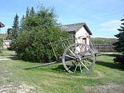
In the 19th century and early 20th century transportation relied on harnessing oxen to Red River carts or horse to wagon. Maritime transportation was via manual labour such as canoe
or wind on sail and utilized the North Saskatchewan River
or South Saskatchewan River
routes mainly. Water or land travel speeds was approximately 8 to 15 kilometres per hour (5 to 9 miles per hour).
Settlement was along river routes, and trade was locally concentrated initially on fur trading posts. Agricultural commodities were perishable, and trade centers were within 50 kilometres. Rural areas centered on villages, and they were approximately 10 kilometres (6.2 mi) apart. The advent of steam railways and steamships connected resources and markets of vast distances in the late 19th century.
Automobile
and truck
travel was employed in the early 20th century with highways and roads being under construction. The roadways ran parallel to the rail lines. The auto was abandoned in the depression years of the dirty thirties, and cars were towed by horse and became known as Bennett Buggies
. The years following World War II
showed much growth as the social economic lifestyle of Saskatchewan changed considerably. Gone were the farmers on each quarter section, and also leaving the prairie landscape were elevators. Grain storage elevators used to be required every 6 miles for loads by horse and cart. Combines introduced large scale farms, trucks introduced larger centres with a larger quantity of elevators. In the 1940s the branch rail lines were not economically feasible, were abandoned, and soon disappeared. As farms increased in size township roads and road allowances became part of the field.
 Historically buffalo and Red River cart trails criss-crossed the prairies. Métis
fur traders and brigades would follow these trails freighting supplies for the Hudson's Bay Company
. Originally following trails created by bison, trails connected together trading posts, North-West Mounted Police forts and barracks. The Dominion government boundary survey trail, the North-West Mounted Police Red Coat trail, American–Canadian boundary trails, telegraph trail, railway trail and rebellion trails were later trails. Due to the hard compaction of prairie sod, the remnants of this trail are still visible via satellite imaging to the trained historian eye.
From Winnipeg
, Manitoba
through to Edmonton
, Alberta
was the famed Carlton Trail
also known as the Saskatchewan or Edmonton trail. The trail went from Fort Ellice east of the present Manitoba
Saskatchewan
border northwest to Fort Carlton, and followed the North Saskatchewan River
, and onwards to Jackfish Lake and thence across the present Alberta
Saskatchewan
border.
Fort Qu'Appelle
, Prince Albert
and the territorial capital, Battleford were the main centers in the 19th century. From these extended a variety of trails as spokes extend from the hub on a wheel.
The boundary survey trail was a 30 feet (9.1 m) wide trail cut through timber and brush by a surveying team marking the 49th parallel beginning between 1872 and 1874. In 1874, the North-West Mounted Police were dispatched to Fort Whoop Up (Alberta
). They travelled through the United States
to the Manitoba
border, and from there were to follow the boundary survey trail to Fort Whoop Up. There actual route extended through Roche Percee, the Cypress Hills, Ponteix, and near Medicine Hat. 1875 marked the beginnings of the Telegraph Trail which was a 132 feet (40.2 m) wide trail from Fort Pelly, to Fort Carlton, Humboldt, Prince Albert, Battleford, and onwards to Edmonton. This was to be the initial stages for the transcontinental railway to travel through the more populated areas of the fur trade area and the North-West Territories' capital, Battleford. The southern area of the North-West territories was deemed in Palliser's report to be a vast desert and unfit for human habitation.
The first Canadian transcontinental railway was constructed by the Canadian Pacific Railway
between 1881 and 1885. The first proposal was northerly through the Saskatchewan provisional district of the North-West Territories
to support the fur trade. The final established route was through the Assiniboia provisional district of the North-West Territories. Towns such as Moosomin
, Qu'Appelle
, Regina
, Moose Jaw and Swift Current sprang up along the railway and became trade centres. The new economy saw grain and agricultural farming as a viable alternative, and Clifford Sifton
implemented a massive immigration policy in support of settling the West. The rail lines followed the established trails generally as the most practical method of travelling through the prairies. After the great east-west transcontinental railway was built, north-south connector branch lines were established. In 1885, the Regina and Long Lake railroad connected Regina
and Craven
. The railway was eventually expanded north to Prince Albert
. The Regina and Long Lake railroad or The Qu'Appelle, Long Lake and Saskatchewan Railway crossed the South Saskatchewan River
at Saskatoon
, Hub city in 1890. In 1907 the communities of Melville, The Rail Centre, and Biggar, Saskatchewan
became divisional point
s for the Grand Trunk Pacific Railway
. Moose Jaw, dubbed Little Chicago, was the northern terminus on the Soo Line, which ran to Chicago, and provided a route during the prohibition years for alcohol freighting between Canada and the United States.
The 1920s saw the largest rise in rail line track as the CPR
and CNR
fell into competition to provide rail service within ten kilometres. In the 1960s there were applications for abandonment of branch lines.
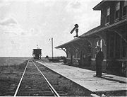
Today the only two passenger rail services in the province are The Canadian
and the Winnipeg – Churchill train both operated by Via Rail
. The Canadian is a transcontinental service linking Toronto with Vancouver. Within Saskatchewan The Canadian calls at Melville
, Watrous
, Saskatoon
, Biggar
and Unity
stations. The Winnipeg - Churchill train calls at Togo
, Kamsack
, Veregin
, Mikado
, Canora
, Sturgis
, Endeavour
, Reserve
, and Hudson Bay
.
There are nearly 1,734 km of Short-line freight railways in the province, these railways are regulated by the Provincial government, and include:
By 1921, there were 210000 miles (337,961.4 km) of road allowance in the province which began as dirt roads. A system began of improved and unimproved dirt, gravel, oil-gravel surfaced roads, and all weather paved roads and highways. Currently Saskatchewan Highways and Transportation
operates over 26000 kilometres (16,155.7 mi) of highways and divided highways
, over 800 bridges, 12 separate ferries, and one barge. There are also municipal roads which comprise different surfaces. Asphalt concrete pavements comprise almost 9000 kilometres (5,592.4 mi), granular pavement almost 5000 kilometres (3,106.9 mi), non structural or thin membrane surface TMS are close to 7000 kilometres (4,349.6 mi) and finally gravel highways make up over 5600 kilometres (3,479.7 mi) through the province. TMS roads are maintained by the provincial government department: Saskatchewan Highways and Transportation. In the northern sector, ice road
s which can only be navigated in the winter months comprise another approximately 150 kilometres (93.2 mi) of travel. Dirt roads also still exist in rural areas and would be maintained by the local resident. All in all Saskatchewan consists of over 250000 kilometres (155,343.2 mi) of roads and highways, the highest amount of road surface compared to any other Canadian province. Roads need to be constructed for the hot summer months, as well as the frigid winter months. Saskatchewan Highways and Transportation seeks to provide an operational transportation system that ensures the safe travel of people and products within a vast province. Crack filling, snow and ice removal, pavement marking, signage, lighting and infrastructure planning. The rural municipalities
care for rural roads of which 97 per cent are gravel and the rest asphalt surface. Road transport provides short and long haul movement for both commercial freight and passenger traffic. Short haul traffic moving small volumes is an economically feasible method low cost method of freight hauling.
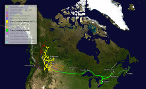
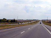 The infamous highways in Saskatchewan are the Trans Canada expressway
, Yellowhead Highway
northern Trans Canada route, Louis Riel Trail
, CanAm Highway
, Red Coat Trail
, Northern Woods and Water route
, and Saskota travel route
.
The Government of Canada
has agreed to contribute $20 million for two new interchanges in Saskatoon
. One of them being at the Sk Hwy 219
/ Lorne Ave intersection with Circle Drive, the other at the Senator Sid Buckwold Bridge (Idylwyld Freeway) and Circle Drive. This is part of the Asia-Pacific Gateway and Corridor Initiative to improve access to the Canadian National Railway's
intermodal freight terminal thereby increasing Asia-Pacific trade. Also, the Government of Canada
will contribute $27 million to Regina
to construct a Canadian Pacific Railway CPR
intermodal facility and improve infrastructure transportation to the facility from both national highway networks, Sk Hwy 1, the TransCanada Highway
and Sk Hwy 11, Louis Riel Trail
. This also is part of the Asia-Pacific Gateway and Corridor Initiative to improve access to the CPR terminal and increase Asia-Pacific trade.
As of 1946, the Saskatchewan Transportation Company (STC) was formed to provide inter city transportation services via highway bus service.
or South Saskatchewan River
routes. Early ferry service and steamship travel were employed on the major waterways.
Barges for freight transfer have used the Athabasca River servicing Uranium City
, Fond du Lac, Stony Rapids
and Black Lake
. Wollaston Lake barge services Wollaston lake
.
As early as 1874 the SS Northcote travelled between Grand Rapids, Manitoba
and went as far west as Edmonton
, Alberta
, through Carlton House on the North Saskatchewan River
. The City of Medicine Hat traversed the South Saskatchewan River
waters near Saskatoon
. Carrot River used steamships to aid in the logging industry. Last Mountain Lake (or Long Lake) used steamships and was a main impetus for the formation of the Qu'Appelle Long Lake and Saskatchewan Railway and Steamship Company (QLLR). The North West Navigation Co. had four steamships to aid in the fur trade industry, Princess, Marquette, Colville, and Glendevon. Winnipeg and Western Company's had three steamers, the Northcote, the Marquis and North West.
. 1871 saw the ferry crossing at Gabriel's Crossing near present day St. Laurent Ferry. In 1883 a ferry on the Battleford Trail was able to provide crossing service for two red river carts across the South Saskatchewan River
at Saskatchewan Landing. This ferry operated until 1953 when the second bridge was officially opened.
 Early corduroy log road bridges, and rail bridges were the precursors to vehicular traffic bridges.
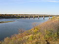
The Qu’Appelle, Long Lake and Saskatchewan Railway Company built a railway bridge in 1890 at Saskatoon crossing the South Saskatchewan River
. Saskatoon is termed "The City of Bridges". By 1908, another two railway bridges were constructed in Saskatoon, the McDonald or CP Railway Bridge and the Grand Trunk or CN
Railway Bridge. The Traffic Bridge, a truss bridge
opened October 10, 1907, as the first vehicle bridge in Saskatoon.
North Battleford, Swift Current and Nipawin
constructed railway bridges.
The Ceepee bridge (later renamed the Borden Bridge)
was built 1936 across the North Saskatchewan River
between Saskatoon
and the Battlefords. This bridge has been abandoned, and replaced.
In southwest Saskatchewan, near Gull Lake
, North Battleford, Scotsguard
and Outlook
are abandoned highway traffic bridges.
In total, there are 3,050 bridges maintained by the Department of Highways in Saskatchewan.
and an RCAF
training school was established. Trans-Canada Air Lines began 1947. The Saskatoon Airport (YXE) was named the John G. Diefenbaker Airport in the official ceremony, June 23, 1993.
Roland J. Groome Airfield is the official designation for the Regina International Airport
(YQR) as of August 3, 2005. The Regina Flying Club sought to establish an airport as of 1927, and in 1930 the Regina Municipal Airport was constructed.
Under the British Commonwealth Air Training Plan (BCATP), twenty Service Flying Training Schools (RAF) were established at various Saskatchewan locations in World War II
. Moose Jaw RCAF is home to the aeronautics team, the Snowbirds.
Airlines offering service to Saskatchewan are Air Canada, WestJet Airlines, Transwest Air, Norcanair Airlines, La Ronge Aviation Services Ltd, La Loche Airways, Osprey Wings Ltd, Buffalo Narrows Airways Ltd, Skyservice Airlines, Île-à-la-Crosse Airways Ltd, Voyage Air, Pronto Airways, Venture Air Ltd, Pelican Narrows Air Service, Jackson Air Services Ltd, and Northern Dene Airways Ltd.
 Pipelines are part of the energy extraction
and transportation network of Canada and, in this regard, may carry natural gas
, natural gas liquids, crude oil, synthetic crude
or other petroleum
based products. The 1930s saw the first pipe line system in Lloydminster
.
Skytrail, is Canada's Longest Pedestrian Bridge which is located in the Outlook & District Regional Park. The Saskatchewan Trails Association brings together information for trail enthusiasts of all forms hikers, cyclists, horseback riders, skiers, ski-dooers or canoeists. The Three Rivers Trail Association (TRTA) is developing interpretative trails between the Arm River, the Qu'Appelle River and the South Saskatchewan Rivers. The Meewasin Authority has constructed and maintained a series of walking trails along the South Saskatchewan River
banks in Saskatoon
.
Saskatchewan
Saskatchewan is a prairie province in Canada, which has an area of . Saskatchewan is bordered on the west by Alberta, on the north by the Northwest Territories, on the east by Manitoba, and on the south by the U.S. states of Montana and North Dakota....
is the movement of people and goods from one place to another within the province. The term is derived from the Latin trans ("across") and portare ("to carry"). Transportation in Saskatchewan includes an infrastructure system of roads, highways, freeways, airports, ferries, pipelines, trails, waterways and railway systems serving a population of approximately 1,003,299 (according to 2007 estimates) inhabitants year-round. It is funded primarily with local, rural municipality
Rural municipality
A rural municipality, often abbreviated RM, is a form of municipality in the Canadian provinces of Manitoba and Saskatchewan, perhaps best comparable to counties or townships in the western United States...
and federal
Canada
Canada is a North American country consisting of ten provinces and three territories. Located in the northern part of the continent, it extends from the Atlantic Ocean in the east to the Pacific Ocean in the west, and northward into the Arctic Ocean...
government funds.
European contact
Early EuropeEurope
Europe is, by convention, one of the world's seven continents. Comprising the westernmost peninsula of Eurasia, Europe is generally 'divided' from Asia to its east by the watershed divides of the Ural and Caucasus Mountains, the Ural River, the Caspian and Black Seas, and the waterways connecting...
an settler
Settler
A settler is a person who has migrated to an area and established permanent residence there, often to colonize the area. Settlers are generally people who take up residence on land and cultivate it, as opposed to nomads...
s and explorers in Canada
Canada
Canada is a North American country consisting of ten provinces and three territories. Located in the northern part of the continent, it extends from the Atlantic Ocean in the east to the Pacific Ocean in the west, and northward into the Arctic Ocean...
introduced the wheel
Wheel
A wheel is a device that allows heavy objects to be moved easily through rotating on an axle through its center, facilitating movement or transportation while supporting a load, or performing labor in machines. Common examples found in transport applications. A wheel, together with an axle,...
to North America
North America
North America is a continent wholly within the Northern Hemisphere and almost wholly within the Western Hemisphere. It is also considered a northern subcontinent of the Americas...
's Aboriginal
Aboriginal peoples in Canada
Aboriginal peoples in Canada comprise the First Nations, Inuit and Métis. The descriptors "Indian" and "Eskimo" have fallen into disuse in Canada and are commonly considered pejorative....
peoples, who relied on canoe
Canoe
A canoe or Canadian canoe is a small narrow boat, typically human-powered, though it may also be powered by sails or small electric or gas motors. Canoes are usually pointed at both bow and stern and are normally open on top, but can be decked over A canoe (North American English) or Canadian...
s, york boat, bateaux and kayak
Kayak
A kayak is a small, relatively narrow, human-powered boat primarily designed to be manually propelled by means of a double blade paddle.The traditional kayak has a covered deck and one or more cockpits, each seating one paddler...
s, in addition to the snowshoe
Snowshoe
A snowshoe is footwear for walking over the snow. Snowshoes work by distributing the weight of the person over a larger area so that the person's foot does not sink completely into the snow, a quality called "flotation"....
, toboggan
Toboggan
A toboggan is a simple sled which is a traditional form of transport used by the Innu and Cree of northern Canada. In modern times, it is used on snow to carry one or more people down a hill or other slope for recreation. Designs vary from simple, traditional models to modern engineered composites...
and sled
Sled
A sled, sledge, or sleigh is a land vehicle with a smooth underside or possessing a separate body supported by two or more smooth, relatively narrow, longitudinal runners that travels by sliding across a surface. Most sleds are used on surfaces with low friction, such as snow or ice. In some cases,...
in winter. Europeans adopted these technologies as Europeans pushed deeper into the continent's interior, and were thus able to travel via the waterways that fed from the St. Lawrence River Great Lakes
Great Lakes
The Great Lakes are a collection of freshwater lakes located in northeastern North America, on the Canada – United States border. Consisting of Lakes Superior, Michigan, Huron, Erie, and Ontario, they form the largest group of freshwater lakes on Earth by total surface, coming in second by volume...
route and Hudson Bay
Hudson Bay
Hudson Bay , sometimes called Hudson's Bay, is a large body of saltwater in northeastern Canada. It drains a very large area, about , that includes parts of Ontario, Quebec, Saskatchewan, Alberta, most of Manitoba, southeastern Nunavut, as well as parts of North Dakota, South Dakota, Minnesota,...
Churchill River
Churchill River (Hudson Bay)
The Churchill River is a major river in Alberta, Saskatchewan and Manitoba, Canada. From the head of the Churchill Lake it is 1,609 km long. It was named after John Churchill, 1st Duke of Marlborough and governor of the Hudson's Bay Company from 1685 to 1691...
route and then across land to Saskatchewan.
In the 19th century and early 20th century transportation relied on harnessing oxen to Red River carts or horse to wagon. Maritime transportation was via manual labour such as canoe
Canoe
A canoe or Canadian canoe is a small narrow boat, typically human-powered, though it may also be powered by sails or small electric or gas motors. Canoes are usually pointed at both bow and stern and are normally open on top, but can be decked over A canoe (North American English) or Canadian...
or wind on sail and utilized the North Saskatchewan River
North Saskatchewan River
The North Saskatchewan River is a glacier-fed river that flows east from the Canadian Rockies to central Saskatchewan. It is one of two major rivers that join to make up the Saskatchewan River....
or South Saskatchewan River
South Saskatchewan River
The South Saskatchewan River is a major river in Canada that flows through the provinces of Alberta and Saskatchewan....
routes mainly. Water or land travel speeds was approximately 8 to 15 kilometres per hour (5 to 9 miles per hour).
Settlement was along river routes, and trade was locally concentrated initially on fur trading posts. Agricultural commodities were perishable, and trade centers were within 50 kilometres. Rural areas centered on villages, and they were approximately 10 kilometres (6.2 mi) apart. The advent of steam railways and steamships connected resources and markets of vast distances in the late 19th century.
Automobile
Automobile
An automobile, autocar, motor car or car is a wheeled motor vehicle used for transporting passengers, which also carries its own engine or motor...
and truck
Truck
A truck or lorry is a motor vehicle designed to transport cargo. Trucks vary greatly in size, power, and configuration, with the smallest being mechanically similar to an automobile...
travel was employed in the early 20th century with highways and roads being under construction. The roadways ran parallel to the rail lines. The auto was abandoned in the depression years of the dirty thirties, and cars were towed by horse and became known as Bennett Buggies
Bennett buggy
A Bennett buggy was a term used in Canada during the Great Depression to describe a car which had its engine and windows taken out and was pulled by a horse...
. The years following World War II
World War II
World War II, or the Second World War , was a global conflict lasting from 1939 to 1945, involving most of the world's nations—including all of the great powers—eventually forming two opposing military alliances: the Allies and the Axis...
showed much growth as the social economic lifestyle of Saskatchewan changed considerably. Gone were the farmers on each quarter section, and also leaving the prairie landscape were elevators. Grain storage elevators used to be required every 6 miles for loads by horse and cart. Combines introduced large scale farms, trucks introduced larger centres with a larger quantity of elevators. In the 1940s the branch rail lines were not economically feasible, were abandoned, and soon disappeared. As farms increased in size township roads and road allowances became part of the field.
Trails
Métis people (Canada)
The Métis are one of the Aboriginal peoples in Canada who trace their descent to mixed First Nations parentage. The term was historically a catch-all describing the offspring of any such union, but within generations the culture syncretised into what is today a distinct aboriginal group, with...
fur traders and brigades would follow these trails freighting supplies for the Hudson's Bay Company
Hudson's Bay Company
The Hudson's Bay Company , abbreviated HBC, or "The Bay" is the oldest commercial corporation in North America and one of the oldest in the world. A fur trading business for much of its existence, today Hudson's Bay Company owns and operates retail stores throughout Canada...
. Originally following trails created by bison, trails connected together trading posts, North-West Mounted Police forts and barracks. The Dominion government boundary survey trail, the North-West Mounted Police Red Coat trail, American–Canadian boundary trails, telegraph trail, railway trail and rebellion trails were later trails. Due to the hard compaction of prairie sod, the remnants of this trail are still visible via satellite imaging to the trained historian eye.
From Winnipeg
Winnipeg
Winnipeg is the capital and largest city of Manitoba, Canada, and is the primary municipality of the Winnipeg Capital Region, with more than half of Manitoba's population. It is located near the longitudinal centre of North America, at the confluence of the Red and Assiniboine Rivers .The name...
, Manitoba
Manitoba
Manitoba is a Canadian prairie province with an area of . The province has over 110,000 lakes and has a largely continental climate because of its flat topography. Agriculture, mostly concentrated in the fertile southern and western parts of the province, is vital to the province's economy; other...
through to Edmonton
Edmonton
Edmonton is the capital of the Canadian province of Alberta and is the province's second-largest city. Edmonton is located on the North Saskatchewan River and is the centre of the Edmonton Capital Region, which is surrounded by the central region of the province.The city and its census...
, Alberta
Alberta
Alberta is a province of Canada. It had an estimated population of 3.7 million in 2010 making it the most populous of Canada's three prairie provinces...
was the famed Carlton Trail
Carlton Trail
The Carlton Trail was the primary land transportation route connecting the various parts of the Canadian Northwest for most of the 19th Century. It stretched from the Red River Colony up to what is today Fort Qu'Appelle, Saskatchewan via Fort Ellice...
also known as the Saskatchewan or Edmonton trail. The trail went from Fort Ellice east of the present Manitoba
Manitoba
Manitoba is a Canadian prairie province with an area of . The province has over 110,000 lakes and has a largely continental climate because of its flat topography. Agriculture, mostly concentrated in the fertile southern and western parts of the province, is vital to the province's economy; other...
Saskatchewan
Saskatchewan
Saskatchewan is a prairie province in Canada, which has an area of . Saskatchewan is bordered on the west by Alberta, on the north by the Northwest Territories, on the east by Manitoba, and on the south by the U.S. states of Montana and North Dakota....
border northwest to Fort Carlton, and followed the North Saskatchewan River
North Saskatchewan River
The North Saskatchewan River is a glacier-fed river that flows east from the Canadian Rockies to central Saskatchewan. It is one of two major rivers that join to make up the Saskatchewan River....
, and onwards to Jackfish Lake and thence across the present Alberta
Alberta
Alberta is a province of Canada. It had an estimated population of 3.7 million in 2010 making it the most populous of Canada's three prairie provinces...
Saskatchewan
Saskatchewan
Saskatchewan is a prairie province in Canada, which has an area of . Saskatchewan is bordered on the west by Alberta, on the north by the Northwest Territories, on the east by Manitoba, and on the south by the U.S. states of Montana and North Dakota....
border.
Fort Qu'Appelle
Fort Qu'Appelle, Saskatchewan
These figures do not include the substantial population living along the shores of the Fishing Lakes.-Origins:The current site is the third Fort Qu'Appelle. The first was a North West Company trading post , also in the valley but near what is now the Saskatchewan-Manitoba border...
, Prince Albert
Prince Albert, Saskatchewan
Prince Albert is the third-largest city in Saskatchewan, Canada. It is situated in the centre of the province on the banks of the North Saskatchewan River. The city is known as the "Gateway to the North" because it is the last major centre along the route to the resources of northern Saskatchewan...
and the territorial capital, Battleford were the main centers in the 19th century. From these extended a variety of trails as spokes extend from the hub on a wheel.
The boundary survey trail was a 30 feet (9.1 m) wide trail cut through timber and brush by a surveying team marking the 49th parallel beginning between 1872 and 1874. In 1874, the North-West Mounted Police were dispatched to Fort Whoop Up (Alberta
Alberta
Alberta is a province of Canada. It had an estimated population of 3.7 million in 2010 making it the most populous of Canada's three prairie provinces...
). They travelled through the United States
United States
The United States of America is a federal constitutional republic comprising fifty states and a federal district...
to the Manitoba
Manitoba
Manitoba is a Canadian prairie province with an area of . The province has over 110,000 lakes and has a largely continental climate because of its flat topography. Agriculture, mostly concentrated in the fertile southern and western parts of the province, is vital to the province's economy; other...
border, and from there were to follow the boundary survey trail to Fort Whoop Up. There actual route extended through Roche Percee, the Cypress Hills, Ponteix, and near Medicine Hat. 1875 marked the beginnings of the Telegraph Trail which was a 132 feet (40.2 m) wide trail from Fort Pelly, to Fort Carlton, Humboldt, Prince Albert, Battleford, and onwards to Edmonton. This was to be the initial stages for the transcontinental railway to travel through the more populated areas of the fur trade area and the North-West Territories' capital, Battleford. The southern area of the North-West territories was deemed in Palliser's report to be a vast desert and unfit for human habitation.
Rail
The first Canadian transcontinental railway was constructed by the Canadian Pacific Railway
Canadian Pacific Railway
The Canadian Pacific Railway , formerly also known as CP Rail between 1968 and 1996, is a historic Canadian Class I railway founded in 1881 and now operated by Canadian Pacific Railway Limited, which began operations as legal owner in a corporate restructuring in 2001...
between 1881 and 1885. The first proposal was northerly through the Saskatchewan provisional district of the North-West Territories
Territorial evolution of Canada
The federation of Canada was created in 1867 when three colonies of British North America were united. One of these colonies split into two new provinces, three other colonies joined later...
to support the fur trade. The final established route was through the Assiniboia provisional district of the North-West Territories. Towns such as Moosomin
Moosomin, Saskatchewan
-Climate:-Moosomin in popular culture:* The Guess Who has a song called "Runnin' Back to Saskatoon"; it also mentions Moose Jaw and Moosomin.-Notable people from Moosomin:...
, Qu'Appelle
Qu'Appelle, Saskatchewan
Qu'Appelle, Saskatchewan, is a small village and formerly in ecclesiastical terms a city, with considerable historic significance located on Trans-Canada Highway and the Canadian Pacific Railway mainline, some east of the provincial capital of Regina.Qu'Appelle was for a time the terminus of the...
, Regina
Regina, Saskatchewan
Regina is the capital city of the Canadian province of Saskatchewan. The city is the second-largest in the province and a cultural and commercial centre for southern Saskatchewan. It is governed by Regina City Council. Regina is the cathedral city of the Roman Catholic and Romanian Orthodox...
, Moose Jaw and Swift Current sprang up along the railway and became trade centres. The new economy saw grain and agricultural farming as a viable alternative, and Clifford Sifton
Clifford Sifton
Sir Clifford Sifton, PC, KCMG was a Canadian politician best known for being Minister of the Interior under Sir Wilfrid Laurier...
implemented a massive immigration policy in support of settling the West. The rail lines followed the established trails generally as the most practical method of travelling through the prairies. After the great east-west transcontinental railway was built, north-south connector branch lines were established. In 1885, the Regina and Long Lake railroad connected Regina
Regina, Saskatchewan
Regina is the capital city of the Canadian province of Saskatchewan. The city is the second-largest in the province and a cultural and commercial centre for southern Saskatchewan. It is governed by Regina City Council. Regina is the cathedral city of the Roman Catholic and Romanian Orthodox...
and Craven
Craven, Saskatchewan
Craven is a village in Saskatchewan. It is located northeast of Lumsden, Saskatchewan in the Qu'Appelle Valley. It lies between the rural municipalities of Longlaketon No. 219 and Lumsden No. 189....
. The railway was eventually expanded north to Prince Albert
Prince Albert, Saskatchewan
Prince Albert is the third-largest city in Saskatchewan, Canada. It is situated in the centre of the province on the banks of the North Saskatchewan River. The city is known as the "Gateway to the North" because it is the last major centre along the route to the resources of northern Saskatchewan...
. The Regina and Long Lake railroad or The Qu'Appelle, Long Lake and Saskatchewan Railway crossed the South Saskatchewan River
South Saskatchewan River
The South Saskatchewan River is a major river in Canada that flows through the provinces of Alberta and Saskatchewan....
at Saskatoon
Saskatoon
Saskatoon is a city in central Saskatchewan, Canada, on the South Saskatchewan River. Residents of the city of Saskatoon are called Saskatonians. The city is surrounded by the Rural Municipality of Corman Park No. 344....
, Hub city in 1890. In 1907 the communities of Melville, The Rail Centre, and Biggar, Saskatchewan
Biggar, Saskatchewan
Biggar is a town in central Saskatchewan, Canada. It is located on Highway #14, west of Saskatoon, the province’s most populous city. Biggar has become well known for its unusual town slogan, an Olympic athlete, and a world-record deer...
became divisional point
Divisional point
In Canada, a divisional point is a railway depot that includes more than just a basic siding or station.- Overview :In the coal and steam era, a divisional point would include such amenities as a substantial passenger station, freight and baggage sheds, a roundhouse, water tank, coaling and sanding...
s for the Grand Trunk Pacific Railway
Grand Trunk Pacific Railway
The Grand Trunk Pacific Railway was a historical Canadian railway.A wholly owned subsidiary of the Grand Trunk Railway , the GTPR was constructed by GTR using loans provided by the Government of Canada. The company was formed in 1903 with a mandate to build west from Winnipeg, Manitoba to the...
. Moose Jaw, dubbed Little Chicago, was the northern terminus on the Soo Line, which ran to Chicago, and provided a route during the prohibition years for alcohol freighting between Canada and the United States.
The 1920s saw the largest rise in rail line track as the CPR
Canadian Pacific Railway
The Canadian Pacific Railway , formerly also known as CP Rail between 1968 and 1996, is a historic Canadian Class I railway founded in 1881 and now operated by Canadian Pacific Railway Limited, which began operations as legal owner in a corporate restructuring in 2001...
and CNR
Canadian National Railway
The Canadian National Railway Company is a Canadian Class I railway headquartered in Montreal, Quebec. CN's slogan is "North America's Railroad"....
fell into competition to provide rail service within ten kilometres. In the 1960s there were applications for abandonment of branch lines.
Today the only two passenger rail services in the province are The Canadian
The Canadian
The Canadian is a Canadian transcontinental passenger train originally operated by the Canadian Pacific Railway between 1955 and 1978. It is currently operated as an Inter-city rail service by Via Rail Canada with service between Union Station in Toronto, Ontario and Pacific Central Station in...
and the Winnipeg – Churchill train both operated by Via Rail
VIA Rail
Via Rail Canada is an independent crown corporation offering intercity passenger rail services in Canada. It is headquartered near Montreal Central Station at 3 Place Ville-Marie in Montreal, Quebec....
. The Canadian is a transcontinental service linking Toronto with Vancouver. Within Saskatchewan The Canadian calls at Melville
Melville railway station
The Melville railway station is on the Canadian National Railway mainline in Melville, Saskatchewan, Canada. The station is served by Via Rail's The Canadian three times per week...
, Watrous
Watrous railway station
The Watrous railway station operated as a Canadian National Railway station in Watrous, Saskatchewan until the station building was torn down. The station site is now served by Via Rail's The Canadian three times per week as a flag stop, with 48 hour advance notice required..- External links :**...
, Saskatoon
Saskatoon railway station
The Saskatoon railway station is currently the only rail station in operation in the City of Saskatoon, Saskatchewan, Canada and is located eight kilometers from the central business district. The station is serviced by The Canadian three times per week. The station is equipped with a ticket...
, Biggar
Biggar railway station
The Biggar Railway Station is a heritage railway station operated by Via Rail located in the town of Biggar, Saskatchewan, Canada.-History:Biggar received its first railway service in 1907 when the Canadian Pacific Railway built a branch line through the area...
and Unity
Unity railway station
The Unity railway station is on the Canadian National Railway mainline in Unity, Saskatchewan. The station is served by Via Rail's The Canadian three times per week as a flag stop .-External links:*...
stations. The Winnipeg - Churchill train calls at Togo
Togo railway station
The Togo Railway Station is a flag stop located in Togo, Saskatchewan, Canada. The station contains a heated and wheelchair accessible shelter with served by Via Rail's Winnipeg – Churchill train.- External links :*...
, Kamsack
Kamsack railway station
The Kamsack Railway Station is a flag stop located in Kamsack, Saskatchewan, Canada. The station is served by Via Rail's Winnipeg – Churchill train.- External links :*...
, Veregin
Veregin railway station
The Veregin Railway Station is a flag stop located in a wooded area in Veregin, Saskatchewan, Canada. The station is served by Via Rail's Winnipeg – Churchill train.- External links :*...
, Mikado
Mikado railway station
The Mikado Railway Station is a flag stop in Mikado, Saskatchewan, Canada. Mikado is part of the rural municipality of Sliding Hills. The station is served by Via Rail's Winnipeg – Churchill train.- External links :*...
, Canora
Canora railway station
The Canora Railway Station is a station in Canora, Saskatchewan, Canada. The station is served by Via Rail's Winnipeg – Churchill train twice per week in each direction....
, Sturgis
Sturgis railway station
The Sturgis Railway Station is a flag stop in Sturgis, Saskatchewan, Canada. The station is served by Via Rail's Winnipeg – Churchill train.The station building was originally constructed by the Canadian Northern Railway as a two story third class station, in 1918; in 1986 the build was moved and...
, Endeavour
Endeavour railway station
The Endeavour Railway Station is a flag stop in Endeavour, Saskatchewan, Canada. The station is served by Via Rail's Winnipeg – Churchill train.- External links :*...
, Reserve
Reserve railway station
The Reserve Railway Station is a flag stop in Reserve, Saskatchewan, Canada. The station is served by Via Rail's Winnipeg – Churchill train.- External links :*...
, and Hudson Bay
Hudson Bay railway station
The Hudson Bay Railway Station is a flag stop in Hudson Bay, Saskatchewan, Canada. The station is served by Via Rail's Winnipeg – Churchill train.- External links :*...
.
There are nearly 1,734 km of Short-line freight railways in the province, these railways are regulated by the Provincial government, and include:
- Southern Rails CooperativeSouthern Rails CooperativeThe Southern Rails Cooperative Ltd. is a Canadian short line railway company operating on trackage in southwest Saskatchewan. Southern Rails Cooperative was the first shortline railway to operate in Saskatchewan and operated as the first modern common carrier shortline railway...
(72 km) - Carlton Trail RailwayCarlton Trail RailwayThe Carlton Trail Railway is a shortline railway with its headquarters in Prince Albert, Saskatchewan. It is operated by OmniTRAX, an American transportation company in Denver, Colorado...
(481 km) - Red Coat Road and RailRed Coat Road and RailThe Red Coat Road & Rail Ltd. is a Canadian short line railway company operating on trackage in Saskatchewan. Red Coat Road & Rail Ltd. is a community owned short-line railways in Saskatchewan. The former Canadian Pacific Railway line from Pangman to Assiniboia, was purchased from CPR in 1999...
(115 km) - Great Western RailwayGreat Western Railway (Saskatchewan)The Great Western Railway is a Canadian short line railway company operating on former Canadian Pacific Railway trackage in southwest Saskatchewan. GWR is the operating company whereas Westcan Rail Saskatchewan Ltd. is the owner of the track and structures...
(496 km) - Thunder Rail (31 km)
- Wheatland RailWheatland RailThe Wheatland Railway Inc. is a Canadian short line railway company operating on trackage in Saskatchewan Canada. Weatland Rail is owned by six north central Saskatchewan municipalities. The railway leases former Canadian National Railway railways...
(74 km) - Fife Lake RailwayFife Lake RailwayThe Fife Lake Railway is a Canadian shortline railway company operating on trackage in Saskatchewan, Canada. The railway is owned by seven local municipalities. The Fife Lake Railway took over the former Canadian Pacific Railway Fife Lake subdivision consisting of 94 km of trackage.The owners of...
(94 km) - Torch River RailTorch River RailThe Torch River Rail Inc is a Canadian short line railway company operating on trackage in Saskatchewan, Canada on the former Canadian Pacific Railway White Fox subdivision that runs from Nipawin to Choiceland....
(45 km) - Great Sandhills RailwayGreat Sandhills RailwayThe Great Sandhills Railway is a Canadian short line railway company operating on trackage in west of Swift Current Saskatchewan, established in 2009. Great Sandhills Railway operates a short-line railways in Saskatchewan on a former Canadian Pacific Railway subdivision...
(187 km) - Last Mountain RailwayLast Mountain RailwayThe Last Mountain Railway is a Canadian short line railway company and subsidiary of Mobil Grain. LMR operates on trackage between Regina and Davidson in Saskatchewan, established in 2009 . The trackage was formerly operated by Canadian National Railway, the LMR interlines with Canadian National...
(136 km)
Highways
The early survey system for homesteading provided for townships which were six miles square (36 sq mi (93.2 km²)). An iron post was driven into the ground at the north east corner of every 1 miles (1.6 km) square. Road allowances were to the north and east of the iron monuments.| Road Allowance | ||||||||||||
|---|---|---|---|---|---|---|---|---|---|---|---|---|
| 31 | 32 | 33 | 34 | 35 | 36 | |||||||
| 30 | 29 | 28 | 27 | 26 | 25 | |||||||
| Road Allowance | ||||||||||||
| 19 | 20 | 21 | 22 | 23 | 24 | |||||||
| 18 | 17 | 16 | 15 | 14 | 13 | |||||||
| Road Allowance | ||||||||||||
| 7 | 8 | 9 | 10 | 11 | 12 | |||||||
| 6 | 5 | 4 | 3 | 2 | 1 | |||||||
| Road Allowance | ||||||||||||
By 1921, there were 210000 miles (337,961.4 km) of road allowance in the province which began as dirt roads. A system began of improved and unimproved dirt, gravel, oil-gravel surfaced roads, and all weather paved roads and highways. Currently Saskatchewan Highways and Transportation
Ministry of Highways and Infrastructure (Saskatchewan)
The Ministry of Highways and Infrastructure or Highways and Infrastructure — Government of Saskatchewan Ministry of Highways is divided into the Operations, Policy and Programs, and Corporate Services Divisions and the Communications Branch. The ministry is the employer of over 1,476...
operates over 26000 kilometres (16,155.7 mi) of highways and divided highways
Dual carriageway
A dual carriageway is a class of highway with two carriageways for traffic travelling in opposite directions separated by a central reservation...
, over 800 bridges, 12 separate ferries, and one barge. There are also municipal roads which comprise different surfaces. Asphalt concrete pavements comprise almost 9000 kilometres (5,592.4 mi), granular pavement almost 5000 kilometres (3,106.9 mi), non structural or thin membrane surface TMS are close to 7000 kilometres (4,349.6 mi) and finally gravel highways make up over 5600 kilometres (3,479.7 mi) through the province. TMS roads are maintained by the provincial government department: Saskatchewan Highways and Transportation. In the northern sector, ice road
Ice road
Ice roads are frozen, human-made structures on the surface of bays, rivers, lakes, or seas in the far north. They link dry land, frozen waterways, portages and winter roads, and are usually remade each winter. Ice roads allow temporary transport to areas with no permanent road access...
s which can only be navigated in the winter months comprise another approximately 150 kilometres (93.2 mi) of travel. Dirt roads also still exist in rural areas and would be maintained by the local resident. All in all Saskatchewan consists of over 250000 kilometres (155,343.2 mi) of roads and highways, the highest amount of road surface compared to any other Canadian province. Roads need to be constructed for the hot summer months, as well as the frigid winter months. Saskatchewan Highways and Transportation seeks to provide an operational transportation system that ensures the safe travel of people and products within a vast province. Crack filling, snow and ice removal, pavement marking, signage, lighting and infrastructure planning. The rural municipalities
Rural municipality
A rural municipality, often abbreviated RM, is a form of municipality in the Canadian provinces of Manitoba and Saskatchewan, perhaps best comparable to counties or townships in the western United States...
care for rural roads of which 97 per cent are gravel and the rest asphalt surface. Road transport provides short and long haul movement for both commercial freight and passenger traffic. Short haul traffic moving small volumes is an economically feasible method low cost method of freight hauling.
Saskatchewan Highway 1
Highway 1 is the Saskatchewan section of the Trans-Canada Highway mainland route. The total distance of the Trans-Canada Highway in Saskatchewan is . The highway traverses Saskatchewan from the western border with Alberta, from Highway 1, to Manitoba where it continues as Highway 1, PTH 1. The...
, Yellowhead Highway
Saskatchewan Highway 16
Highway 16 is a provincial paved highway in the Canadian province of Saskatchewan. It is the Saskatchewan section of the Yellowhead Highway, and also the Trans-Canada Highway Yellowhead section. The main purpose of this highway is to connect Saskatchewan with Canadian cities such as Edmonton and...
northern Trans Canada route, Louis Riel Trail
Saskatchewan Highway 11
Highway 11 is a major north-south highway in Saskatchewan, Canada that connects the province's three largest cities: Regina, Saskatoon and Prince Albert. It is a structural pavement major arterial highway which is approximately long. It is also known as the Louis Riel Trail after the 19th century...
, CanAm Highway
Saskatchewan Highway 2
Highway 2 is a provincial highway in the Canadian province of Saskatchewan. It is the longest Saskatchewan Highway, at 809 km . The highway is partially divided and undivided. However, only about near Moose Jaw, near Chamberlain, and near Prince Albert are divided highway...
, Red Coat Trail
Saskatchewan Highway 13
Highway 13 is a highway in the Canadian province of Saskatchewan. It runs from the Alberta border until it transitions into Highway 2 at the Manitoba border near Antler. Highway 13 is about 676 km long.Highway 13 passes through Shaunavon, Assiniboia, Weyburn, Redvers and Carlyle...
, Northern Woods and Water route
Saskatchewan Highway 55
Highway 55 is a provincial paved undivided highway in the Canadian province of Saskatchewan. It runs from Alberta Highway 55 near the Alberta border until Highway 9. Highway 55 is 652 km long. It forms part of the interprovincial Northern Woods and Water Route.-Attractions:On the West portion...
, and Saskota travel route
Saskatchewan Highway 9
Highway 9, Highway 9 is a provincial paved undivided highway in the Canadian province of Saskatchewan. It runs from North Dakota Highway 8 at the US border near Port of Northgate until it transitions into Provincial Road 283 at the Manitoba border...
.
The Government of Canada
Government of Canada
The Government of Canada, formally Her Majesty's Government, is the system whereby the federation of Canada is administered by a common authority; in Canadian English, the term can mean either the collective set of institutions or specifically the Queen-in-Council...
has agreed to contribute $20 million for two new interchanges in Saskatoon
Saskatoon
Saskatoon is a city in central Saskatchewan, Canada, on the South Saskatchewan River. Residents of the city of Saskatoon are called Saskatonians. The city is surrounded by the Rural Municipality of Corman Park No. 344....
. One of them being at the Sk Hwy 219
Saskatchewan Highway 219
Highway 219 is a secondary highway in the Canadian province of Saskatchewan, running from Saskatoon south to the vicinity of the Gardiner Dam development and the north end of Lake Diefenbaker....
/ Lorne Ave intersection with Circle Drive, the other at the Senator Sid Buckwold Bridge (Idylwyld Freeway) and Circle Drive. This is part of the Asia-Pacific Gateway and Corridor Initiative to improve access to the Canadian National Railway's
Canadian National Railway
The Canadian National Railway Company is a Canadian Class I railway headquartered in Montreal, Quebec. CN's slogan is "North America's Railroad"....
intermodal freight terminal thereby increasing Asia-Pacific trade. Also, the Government of Canada
Government of Canada
The Government of Canada, formally Her Majesty's Government, is the system whereby the federation of Canada is administered by a common authority; in Canadian English, the term can mean either the collective set of institutions or specifically the Queen-in-Council...
will contribute $27 million to Regina
Regina, Saskatchewan
Regina is the capital city of the Canadian province of Saskatchewan. The city is the second-largest in the province and a cultural and commercial centre for southern Saskatchewan. It is governed by Regina City Council. Regina is the cathedral city of the Roman Catholic and Romanian Orthodox...
to construct a Canadian Pacific Railway CPR
Canadian Pacific Railway
The Canadian Pacific Railway , formerly also known as CP Rail between 1968 and 1996, is a historic Canadian Class I railway founded in 1881 and now operated by Canadian Pacific Railway Limited, which began operations as legal owner in a corporate restructuring in 2001...
intermodal facility and improve infrastructure transportation to the facility from both national highway networks, Sk Hwy 1, the TransCanada Highway
Saskatchewan Highway 1
Highway 1 is the Saskatchewan section of the Trans-Canada Highway mainland route. The total distance of the Trans-Canada Highway in Saskatchewan is . The highway traverses Saskatchewan from the western border with Alberta, from Highway 1, to Manitoba where it continues as Highway 1, PTH 1. The...
and Sk Hwy 11, Louis Riel Trail
Saskatchewan Highway 11
Highway 11 is a major north-south highway in Saskatchewan, Canada that connects the province's three largest cities: Regina, Saskatoon and Prince Albert. It is a structural pavement major arterial highway which is approximately long. It is also known as the Louis Riel Trail after the 19th century...
. This also is part of the Asia-Pacific Gateway and Corridor Initiative to improve access to the CPR terminal and increase Asia-Pacific trade.
Urban transport
Urban, suburban, and inter-urban transport includes electric trolleys, electric railway, motor buses, and motor coach. The Saskatoon Electric Railway and Power Company, Moose Jaw Electric Railway Company and the Regina Municipal Railway , were electric railways, and were first operational in 1911. Regina stopped using the electric trolley buses in 1966. Electric street car systems were fully discontinued in Saskatoon as of 1974, and replaced by the Saskatoon Transit Services.As of 1946, the Saskatchewan Transportation Company (STC) was formed to provide inter city transportation services via highway bus service.
Waterways
The main Saskatchewan waterways are the North Saskatchewan RiverNorth Saskatchewan River
The North Saskatchewan River is a glacier-fed river that flows east from the Canadian Rockies to central Saskatchewan. It is one of two major rivers that join to make up the Saskatchewan River....
or South Saskatchewan River
South Saskatchewan River
The South Saskatchewan River is a major river in Canada that flows through the provinces of Alberta and Saskatchewan....
routes. Early ferry service and steamship travel were employed on the major waterways.
Barges for freight transfer have used the Athabasca River servicing Uranium City
Uranium City, Saskatchewan
Uranium City is a settlement in northwestern Saskatchewan, Canada. It is on the northern shores of Lake Athabasca near the border of the Northwest Territories. It is above sea level. The settlement is northwest of Prince Albert, 760 km northeast of Edmonton and south of the Northwest...
, Fond du Lac, Stony Rapids
Stony Rapids, Saskatchewan
Stony Rapids is a northern hamlet in Northern Saskatchewan, Canada, with a total population of 360 residents. Located south of the border to the Northwest Territories, the community is astride the Fond du Lac River...
and Black Lake
Black Lake, Saskatchewan
Black Lake is a small First Nations community in north-eastern Saskatchewan, Canada, located on the northwest shore of Black Lake, at a point where the Fond du Lac River leaves the lake to flow to Lake Athabasca. The population is about 1450. It is home to the Black Lake Denesuline Nation, with...
. Wollaston Lake barge services Wollaston lake
Wollaston Lake, Saskatchewan
Wollaston Lake is a hamlet in Saskatchewan. It is the only community on Wollaston Lake. The community has a population of about 800 people, a quarter of whom are members of the Lac La Hache Indian Band. Access is provided by Wollaston Lake Airport and Highway 905. The highway is on the west side of...
.
As early as 1874 the SS Northcote travelled between Grand Rapids, Manitoba
Manitoba
Manitoba is a Canadian prairie province with an area of . The province has over 110,000 lakes and has a largely continental climate because of its flat topography. Agriculture, mostly concentrated in the fertile southern and western parts of the province, is vital to the province's economy; other...
and went as far west as Edmonton
Edmonton
Edmonton is the capital of the Canadian province of Alberta and is the province's second-largest city. Edmonton is located on the North Saskatchewan River and is the centre of the Edmonton Capital Region, which is surrounded by the central region of the province.The city and its census...
, Alberta
Alberta
Alberta is a province of Canada. It had an estimated population of 3.7 million in 2010 making it the most populous of Canada's three prairie provinces...
, through Carlton House on the North Saskatchewan River
North Saskatchewan River
The North Saskatchewan River is a glacier-fed river that flows east from the Canadian Rockies to central Saskatchewan. It is one of two major rivers that join to make up the Saskatchewan River....
. The City of Medicine Hat traversed the South Saskatchewan River
South Saskatchewan River
The South Saskatchewan River is a major river in Canada that flows through the provinces of Alberta and Saskatchewan....
waters near Saskatoon
Saskatoon
Saskatoon is a city in central Saskatchewan, Canada, on the South Saskatchewan River. Residents of the city of Saskatoon are called Saskatonians. The city is surrounded by the Rural Municipality of Corman Park No. 344....
. Carrot River used steamships to aid in the logging industry. Last Mountain Lake (or Long Lake) used steamships and was a main impetus for the formation of the Qu'Appelle Long Lake and Saskatchewan Railway and Steamship Company (QLLR). The North West Navigation Co. had four steamships to aid in the fur trade industry, Princess, Marquette, Colville, and Glendevon. Winnipeg and Western Company's had three steamers, the Northcote, the Marquis and North West.
Ferry services
There are currently twelve ferry services operating in the province, all under the jurisdiction of the Department of Highways. In the 1920s through to the 1950s there were 36 ferries in operation, the highest number of ferries in the province. In the 1860s the Hudson's Bay Company built a river ferry near Fort Carlton on the North Saskatchewan RiverNorth Saskatchewan River
The North Saskatchewan River is a glacier-fed river that flows east from the Canadian Rockies to central Saskatchewan. It is one of two major rivers that join to make up the Saskatchewan River....
. 1871 saw the ferry crossing at Gabriel's Crossing near present day St. Laurent Ferry. In 1883 a ferry on the Battleford Trail was able to provide crossing service for two red river carts across the South Saskatchewan River
South Saskatchewan River
The South Saskatchewan River is a major river in Canada that flows through the provinces of Alberta and Saskatchewan....
at Saskatchewan Landing. This ferry operated until 1953 when the second bridge was officially opened.
| Ferry | Location | Waterway | Reference |
|---|---|---|---|
| Estuary Estuary Ferry The Estuary Ferry is a ferry in the Canadian province of Saskatchewan near the ghost town of Estuary. The ferry crosses the South Saskatchewan River, providing a link between the north and south side of Range Road 635.... |
connecting Estuary and Laporte Laporte, Saskatchewan Laporte is a hamlet in the Canadian province of Saskatchewan. Listed as a designated place by Statistics Canada, the hamlet had a population of five in the Canada 2006 Census.... |
South Saskatchewan River South Saskatchewan River The South Saskatchewan River is a major river in Canada that flows through the provinces of Alberta and Saskatchewan.... |
|
| Lemsford Lemsford Ferry The Lemsford Ferry is a cable ferry in the Canadian province of Saskatchewan. The ferry crosses the South Saskatchewan River at Lemsford, Saskatchewan, connecting Highway 784 with Highway 784. The ferry is located near the Lemsford Ferry Regional Park.... |
North of Lemsford connecting 32 Saskatchewan Highway 32 Highway 32 is a highway in southwestern Saskatchewan, connecting Leader and Swift Current. It is about long, connecting several rural communities along the route including Abbey, Cabri, Cantaur and Success.-History:... and 30 Saskatchewan Highway 30 Highway 30 is a highway in the Canadian province of Saskatchewan. It runs from the Eston Riverside Regional Park on the South Saskatchewan River until Highway 7. Highway 30 is about 61 km long.-Intersections from south to north:... |
South Saskatchewan River South Saskatchewan River The South Saskatchewan River is a major river in Canada that flows through the provinces of Alberta and Saskatchewan.... |
|
| Lancer Lancer Ferry The Lancer Ferry is a ferry in the Canadian province of Saskatchewan. The ferry crosses the South Saskatchewan River, linking the communities of Lancer with Eston and providing a connection between Highway 30 and Highway 32.... |
North of Lancer Lancer, Saskatchewan -External links:*********-Footnotes:... connecting 32 Saskatchewan Highway 32 Highway 32 is a highway in southwestern Saskatchewan, connecting Leader and Swift Current. It is about long, connecting several rural communities along the route including Abbey, Cabri, Cantaur and Success.-History:... and 30 Saskatchewan Highway 30 Highway 30 is a highway in the Canadian province of Saskatchewan. It runs from the Eston Riverside Regional Park on the South Saskatchewan River until Highway 7. Highway 30 is about 61 km long.-Intersections from south to north:... |
South Saskatchewan River South Saskatchewan River The South Saskatchewan River is a major river in Canada that flows through the provinces of Alberta and Saskatchewan.... |
|
| Riverhurst Riverhurst Ferry The Riverhurst Ferry is a cable ferry in the Canadian province of Saskatchewan. The ferry crosses Lake Diefenbaker, linking Riverhurst on the west bank to Lucky Lake on the east bank. The ferry is how Highway 42 crosses Lake Diefenbaker.... |
Highway 42 Saskatchewan Highway 42 Highway 42 is a highway in the Canadian province of Saskatchewan. It runs from the intersecion of Highway 2 and Highway 202 near Tuxford until Highway 15... and Highway 373 Saskatchewan Highway 373 Highway 373 is a highway in the Canadian province of Saskatchewan. It runs from Highway 42 to Highway 45/Highway 646 near Birsay. Highway 373 is about 14 km long.... |
Lake Diefenbaker Lake Diefenbaker Lake Diefenbaker is a reservoir in Southern Saskatchewan, Canada. It was formed by the construction of Gardiner Dam and the Qu'Appelle River Dam across the South Saskatchewan and Qu'Appelle Rivers respectively. Construction began in 1959 and the lake was filled in 1967. The lake is long with... |
|
| Clarkboro Clarkboro Ferry The Clarkboro Ferry is a cable ferry in the Canadian province of Saskatchewan. The ferry crosses the South Saskatchewan River at Clark's Crossing, carrying Grid Road 784 across the river, and connecting Warman in the west and Aberdeen in the east. The ferry is named for the community of Clarkboro... |
Between Warman Warman, Saskatchewan -History:The town of Warman was born when the Canadian National Railway running from Humboldt to North Battleford intersected with the Canadian Pacific Railway running from Regina to Prince Albert. This took place in the fall of 1904.... and Aberdeen Aberdeen, Saskatchewan -Aberdeen Rec Complex:The Aberdeen Rec Complex is located in the town and consists of a Library, meeting room, ice rink, curling rink, bowling alley, dance studio, music room and meeting rooms.-Water supply:... on 784 Saskatchewan Highway 784 Highway 784 is a highway in the Canadian province of Saskatchewan. It runs from Highway 4 to Highway 41 near Aberdeen. Highway 784 is about 124 km long.Highway 784 also passes near Struan, Dalmeny, Warman, and Clarkboro... |
South Saskatchewan River South Saskatchewan River The South Saskatchewan River is a major river in Canada that flows through the provinces of Alberta and Saskatchewan.... |
|
| Hague Hague Ferry The Hague Ferry is a ferry in the Canadian province of Saskatchewan. The ferry crosses the South Saskatchewan River, as part of Highway 785 near Hague.... |
Between Hague Hague, Saskatchewan -Location:-External links:*... and Aberdeen Aberdeen, Saskatchewan -Aberdeen Rec Complex:The Aberdeen Rec Complex is located in the town and consists of a Library, meeting room, ice rink, curling rink, bowling alley, dance studio, music room and meeting rooms.-Water supply:... |
South Saskatchewan River South Saskatchewan River The South Saskatchewan River is a major river in Canada that flows through the provinces of Alberta and Saskatchewan.... |
|
| St. Laurent St. Laurent Ferry The St. Laurent Ferry is a ferry in the Canadian province of Saskatchewan. The ferry crosses the South Saskatchewan River, linking Grid Road 783 with Grid Road 782 near St. Laurent de Grandin.... |
East of Duck Lake, 11 Saskatchewan Highway 11 Highway 11 is a major north-south highway in Saskatchewan, Canada that connects the province's three largest cities: Regina, Saskatoon and Prince Albert. It is a structural pavement major arterial highway which is approximately long. It is also known as the Louis Riel Trail after the 19th century... and Batoche 225 Saskatchewan Highway 225 Highway 225 is a highway in the Canadian province of Saskatchewan. It runs from Highway 312 to Highway 2 near Domremy. Highway 225 is about 36 km long.... |
South Saskatchewan River South Saskatchewan River The South Saskatchewan River is a major river in Canada that flows through the provinces of Alberta and Saskatchewan.... |
|
| Fenton Fenton Ferry The Fenton Ferry is a ferry in the Canadian province of Saskatchewan. The ferry crosses the South Saskatchewan River, linking Highway 25 with Highway 3 via a grid road north of Fenton.... |
Between 25 Saskatchewan Highway 25 Highway 25 is a provincial highway in the Canadian province of Saskatchewan. It is long and runs from Highway 2 in St. Louis to Highway 3 near Birch Hills.-External links:* -- Scroll down to find Highway 25.... and 3 Saskatchewan Highway 3 Highway 3 is a major provincial paved undivided highway in the Canadian province of Saskatchewan. It runs from the Alberta border, continues west as Alberta Highway 45 to the Manitoba border, and then continues east as Highway 77. Highway 3 is about 615 km long. The CanAm Highway comprises ... on Grid Road |
South Saskatchewan River South Saskatchewan River The South Saskatchewan River is a major river in Canada that flows through the provinces of Alberta and Saskatchewan.... |
|
| Weldon Weldon Ferry The Weldon Ferry is a ferry in the Canadian province of Saskatchewan. The ferry crosses the South Saskatchewan River, linking Highway 682 with Highway 302 north of Weldon.... |
Between 3 Saskatchewan Highway 3 Highway 3 is a major provincial paved undivided highway in the Canadian province of Saskatchewan. It runs from the Alberta border, continues west as Alberta Highway 45 to the Manitoba border, and then continues east as Highway 77. Highway 3 is about 615 km long. The CanAm Highway comprises ... , Weldon Weldon, Saskatchewan -Attractions:Weldon has modern amenities and services, and its population of approximately 250 enjoys a quiet, relaxed lifestyle reminiscent of another era. Many of the residents trace their lineage back to their Norwegian forebears who first established the community just after the turn of the... via 682 Saskatchewan Highway 682 Highway 682 is a highway in the Canadian province of Saskatchewan. It runs from Highway 42 near Meskanaw to the southern terminal of the Weldon Ferry across the South Saskatchewan River, which connects to Highway 302. Highway 682 is about 60 km long.Highway 682 also passes near the... and 302 Saskatchewan Highway 302 Highway 302 is a highway in the Canadian province of Saskatchewan. It runs from the northern terminal of the Weldon Ferry, which connects to Highway 682 across the South Saskatchewan River, to a dead end near the Nisbet Provincial Forest... , Prince Albert Prince Albert, Saskatchewan Prince Albert is the third-largest city in Saskatchewan, Canada. It is situated in the centre of the province on the banks of the North Saskatchewan River. The city is known as the "Gateway to the North" because it is the last major centre along the route to the resources of northern Saskatchewan... |
South Saskatchewan River South Saskatchewan River The South Saskatchewan River is a major river in Canada that flows through the provinces of Alberta and Saskatchewan.... |
|
| Paynton Paynton Ferry The Paynton Ferry is a ferry in the Canadian province of Saskatchewan near Paynton, Saskatchewan. The ferry crosses the North Saskatchewan River, as part of Range Road 674.... |
Between 16 Saskatchewan Highway 16 Highway 16 is a provincial paved highway in the Canadian province of Saskatchewan. It is the Saskatchewan section of the Yellowhead Highway, and also the Trans-Canada Highway Yellowhead section. The main purpose of this highway is to connect Saskatchewan with Canadian cities such as Edmonton and... and 26 Saskatchewan Highway 26 Highway 26 is a highway in the northern portion of the Canadian province of Saskatchewan and begins at Hwy 4 north of North Battleford which sets the southern end of the highway. The concurrency of Highway 224 east with Highway 950 west separates at Highway 26 which demarks the northern extremity. ... via 764 Saskatchewan Highway 764 Highway 764 is a highway in the Canadian province of Saskatchewan. It runs from Highway 219 to Highway 397/Highway 763 near Allan. Highway 764 is about 83 km long.... |
North Saskatchewan River North Saskatchewan River The North Saskatchewan River is a glacier-fed river that flows east from the Canadian Rockies to central Saskatchewan. It is one of two major rivers that join to make up the Saskatchewan River.... |
|
| Wingard Wingard Ferry The Wingard Ferry is a ferry in the Canadian province of Saskatchewan near Wingard, Saskatchewan. The ferry crosses the North Saskatchewan River, as part of Range Road 783.... |
East of Marcelin Marcelin, Saskatchewan -External links:*******-Footnotes:... , 40 Saskatchewan Highway 40 Highway 40 is a highway in the northwest portion of the Canadian province of Saskatchewan connecting Alberta to Highway 3, 4 km west of Shellbrook, Saskatchewan. Areas of this highway between the Alberta border and North Battleford are called The Poundmaker Trail. Pitikwahanapiwiyin Highway... connecting to 11 Saskatchewan Highway 11 Highway 11 is a major north-south highway in Saskatchewan, Canada that connects the province's three largest cities: Regina, Saskatoon and Prince Albert. It is a structural pavement major arterial highway which is approximately long. It is also known as the Louis Riel Trail after the 19th century... Wingard |
North Saskatchewan River North Saskatchewan River The North Saskatchewan River is a glacier-fed river that flows east from the Canadian Rockies to central Saskatchewan. It is one of two major rivers that join to make up the Saskatchewan River.... |
|
| Cecil Cecil Ferry The Cecil Ferry is a ferry that operates in the Canadian province of Saskatchewan east of Prince Albert, Saskatchewan. The ferry crosses the North Saskatchewan River, providing a link between Range Road 635 and Range Road 55.... |
Between 302 Saskatchewan Highway 302 Highway 302 is a highway in the Canadian province of Saskatchewan. It runs from the northern terminal of the Weldon Ferry, which connects to Highway 682 across the South Saskatchewan River, to a dead end near the Nisbet Provincial Forest... and 55 Saskatchewan Highway 55 Highway 55 is a provincial paved undivided highway in the Canadian province of Saskatchewan. It runs from Alberta Highway 55 near the Alberta border until Highway 9. Highway 55 is 652 km long. It forms part of the interprovincial Northern Woods and Water Route.-Attractions:On the West portion... east of Prince Albert Prince Albert, Saskatchewan Prince Albert is the third-largest city in Saskatchewan, Canada. It is situated in the centre of the province on the banks of the North Saskatchewan River. The city is known as the "Gateway to the North" because it is the last major centre along the route to the resources of northern Saskatchewan... |
North Saskatchewan River North Saskatchewan River The North Saskatchewan River is a glacier-fed river that flows east from the Canadian Rockies to central Saskatchewan. It is one of two major rivers that join to make up the Saskatchewan River.... |
Bridges
The Qu’Appelle, Long Lake and Saskatchewan Railway Company built a railway bridge in 1890 at Saskatoon crossing the South Saskatchewan River
South Saskatchewan River
The South Saskatchewan River is a major river in Canada that flows through the provinces of Alberta and Saskatchewan....
. Saskatoon is termed "The City of Bridges". By 1908, another two railway bridges were constructed in Saskatoon, the McDonald or CP Railway Bridge and the Grand Trunk or CN
Canadian National Railway
The Canadian National Railway Company is a Canadian Class I railway headquartered in Montreal, Quebec. CN's slogan is "North America's Railroad"....
Railway Bridge. The Traffic Bridge, a truss bridge
Truss bridge
A truss bridge is a bridge composed of connected elements which may be stressed from tension, compression, or sometimes both in response to dynamic loads. Truss bridges are one of the oldest types of modern bridges...
opened October 10, 1907, as the first vehicle bridge in Saskatoon.
North Battleford, Swift Current and Nipawin
Nipawin, Saskatchewan
There is, however, some dispute regarding the current population of Nipawin, with Tourism Saskatchewan's Saskatchewan Discovery Guide 2010 claiming a population of 5,074, which actually places Nipawin over the population threshold for applying for city status....
constructed railway bridges.
The Ceepee bridge (later renamed the Borden Bridge)
Borden Bridge
Borden Bridge is an abandoned arch bridge that spans across the North Saskatchewan River near Borden, Saskatchewan, Canada. The bridge used to carry Saskatchewan Highway 16, but is still open to foot traffic.-History:...
was built 1936 across the North Saskatchewan River
North Saskatchewan River
The North Saskatchewan River is a glacier-fed river that flows east from the Canadian Rockies to central Saskatchewan. It is one of two major rivers that join to make up the Saskatchewan River....
between Saskatoon
Saskatoon
Saskatoon is a city in central Saskatchewan, Canada, on the South Saskatchewan River. Residents of the city of Saskatoon are called Saskatonians. The city is surrounded by the Rural Municipality of Corman Park No. 344....
and the Battlefords. This bridge has been abandoned, and replaced.
In southwest Saskatchewan, near Gull Lake
Gull Lake, Saskatchewan
-History:The history of the Gull Lake community dates back to 1906, when a development company Conrad and Price acquired and surveyed the town site and subdivided it into blocks. Unlike most other towns located along the C.P.R. main line, Gull Lake was not planned and established by the railroad....
, North Battleford, Scotsguard
Scotsguard, Saskatchewan
Scotsguard is a small hamlet in Bone Creek Rural Municipality No. 108, Saskatchewan, Canada. Located on highway 13 also known as the historic Red Coat Trail, about 10 km northeast of Shaunavon, Saskatchewan.-Demographics:...
and Outlook
Outlook, Saskatchewan
-History:Settlement of the area began in the early 1900s with farmers, immigrants moving into the area looking for farmland. Outlook officially started as a settlement on August 26, 1908 when the Canadian Pacific Railway commenced the auction of lots...
are abandoned highway traffic bridges.
In total, there are 3,050 bridges maintained by the Department of Highways in Saskatchewan.
Airports
Saskatoon featured its inaugural Air Harbour in 1913 near the exhibition grounds. The Hudson Bay Slough site established in 1922 became the site for the present air port. The Department of National Defence, Civil Aviation Branch requested the City of Saskatoon to establish an airport. Saskatoon Airport was part of the Department of National Defence during the years of World War IIWorld War II
World War II, or the Second World War , was a global conflict lasting from 1939 to 1945, involving most of the world's nations—including all of the great powers—eventually forming two opposing military alliances: the Allies and the Axis...
and an RCAF
Royal Canadian Air Force
The history of the Royal Canadian Air Force begins in 1920, when the air force was created as the Canadian Air Force . In 1924 the CAF was renamed the Royal Canadian Air Force and granted royal sanction by King George V. The RCAF existed as an independent service until 1968...
training school was established. Trans-Canada Air Lines began 1947. The Saskatoon Airport (YXE) was named the John G. Diefenbaker Airport in the official ceremony, June 23, 1993.
Roland J. Groome Airfield is the official designation for the Regina International Airport
Regina International Airport
Regina International Airport is an international airport located in Regina, Saskatchewan, Canada, located south-west and west south-west of the city centre. It is run by the Regina Airport Authority. It is, as of 2010, the second busiest airport in Saskatchewan Regina International Airport is...
(YQR) as of August 3, 2005. The Regina Flying Club sought to establish an airport as of 1927, and in 1930 the Regina Municipal Airport was constructed.
Under the British Commonwealth Air Training Plan (BCATP), twenty Service Flying Training Schools (RAF) were established at various Saskatchewan locations in World War II
World War II
World War II, or the Second World War , was a global conflict lasting from 1939 to 1945, involving most of the world's nations—including all of the great powers—eventually forming two opposing military alliances: the Allies and the Axis...
. Moose Jaw RCAF is home to the aeronautics team, the Snowbirds.
Airlines offering service to Saskatchewan are Air Canada, WestJet Airlines, Transwest Air, Norcanair Airlines, La Ronge Aviation Services Ltd, La Loche Airways, Osprey Wings Ltd, Buffalo Narrows Airways Ltd, Skyservice Airlines, Île-à-la-Crosse Airways Ltd, Voyage Air, Pronto Airways, Venture Air Ltd, Pelican Narrows Air Service, Jackson Air Services Ltd, and Northern Dene Airways Ltd.
Pipelines
Petroleum production in Canada
Petroleum production in Canada is a major industry which is important to the economy of North America. Canada is the sixth largest oil producing country in the world. In 2008 it produced an average of of crude oil, crude bitumen and natural gas condensate. Of that amount, 45% was conventional...
and transportation network of Canada and, in this regard, may carry natural gas
Natural gas
Natural gas is a naturally occurring gas mixture consisting primarily of methane, typically with 0–20% higher hydrocarbons . It is found associated with other hydrocarbon fuel, in coal beds, as methane clathrates, and is an important fuel source and a major feedstock for fertilizers.Most natural...
, natural gas liquids, crude oil, synthetic crude
Synthetic crude
Synthetic crude is the output from a bitumen/extra heavy oil upgrader facility used in connection with oil sand production. It may also refer to shale oil, an output from an oil shale pyrolysis. The properties of the synthetic crude depend on the processes used in the upgrading. Typically, it is...
or other petroleum
Petroleum
Petroleum or crude oil is a naturally occurring, flammable liquid consisting of a complex mixture of hydrocarbons of various molecular weights and other liquid organic compounds, that are found in geologic formations beneath the Earth's surface. Petroleum is recovered mostly through oil drilling...
based products. The 1930s saw the first pipe line system in Lloydminster
Lloydminster
Lloydminster is a Canadian city which has the unusual geographic distinction of straddling the provincial border between Alberta and Saskatchewan...
.
Hiking trails in Saskatchewan
The Trans Canada Trail is a trail traversing every province across Canada. Across Saskatchewan are a variety of trails, hiking, cross country ski trails, and snowmobile or skidoo trails. Hiking or backpacking trails abound across Saskatchewan, the most notable is the hike into Grey Owl's Cabin within the Prince Albert National park.Skytrail, is Canada's Longest Pedestrian Bridge which is located in the Outlook & District Regional Park. The Saskatchewan Trails Association brings together information for trail enthusiasts of all forms hikers, cyclists, horseback riders, skiers, ski-dooers or canoeists. The Three Rivers Trail Association (TRTA) is developing interpretative trails between the Arm River, the Qu'Appelle River and the South Saskatchewan Rivers. The Meewasin Authority has constructed and maintained a series of walking trails along the South Saskatchewan River
South Saskatchewan River
The South Saskatchewan River is a major river in Canada that flows through the provinces of Alberta and Saskatchewan....
banks in Saskatoon
Saskatoon
Saskatoon is a city in central Saskatchewan, Canada, on the South Saskatchewan River. Residents of the city of Saskatoon are called Saskatonians. The city is surrounded by the Rural Municipality of Corman Park No. 344....
.
See also
- List of Saskatchewan provincial highways
- Ministry of Highways and InfrastructureMinistry of Highways and Infrastructure (Saskatchewan)The Ministry of Highways and Infrastructure or Highways and Infrastructure — Government of Saskatchewan Ministry of Highways is divided into the Operations, Policy and Programs, and Corporate Services Divisions and the Communications Branch. The ministry is the employer of over 1,476...
- Numbered highways in Canada
- Saskatchewan Portal
- Roads in SaskatchewanRoads in SaskatchewanSaskatchewan, the middle of Canada's three prairie provinces, has an area of and population of 990,212 , mostly living in the southern half of the province....
- WikiProject Canada Roads / Saskatchewan