

North Saskatchewan River
Encyclopedia
The North Saskatchewan River is a glacier
-fed river that flows east from the Canadian Rockies
to central Saskatchewan
. It is one of two major rivers that join to make up the Saskatchewan River
.
The Saskatchewan River system is the largest shared between the Canadian
provinces of Alberta
and Saskatchewan. It includes most of southern Alberta and southern Saskatchewan, before crossing into central Manitoba
.
it has a mean discharge of 245 m3/s. The yearly discharge at the Alberta/Saskatchewan border is more than 7 k m3.
The river begins above 1,800 metres at the toe of the Saskatchewan Glacier
in the Columbia Icefield
, and flows southeast through Banff National Park
alongside the Icefields Parkway
. At the junction of the David Thompson Highway (Highway 11), it initially turns northeast for 10 kilometres before switching to a more direct eastern flow for about 30 km. At this point, it turns north where it eventually arrives at Abraham Lake
. Bighorn Dam
constricts the north end of Abraham Lake, where the North Saskatchewan emerges to track eastward to Rocky Mountain House. At Rocky Mountain House, the river abruptly turns north again for 100 km where it switches east towards Edmonton, Alberta. In Edmonton, the river passes through the centre of the city in a northeasterly direction and out towards Smoky Lake
at which point it quickly changes to the southeast and then more to the east as it makes it way to the Alberta–Saskatchewan boundary.
From the border, the river flows southeast between North Battleford
and Battleford and on in the direction of Saskatoon. About 40 km northwest of Saskatoon, near Langham
, the river veers to the northeast where it passes through the City of Prince Albert
. About 30 km downstream of Prince Albert, the North Saskatchewan River joins the South Saskatchewan River
at Saskatchewan River Forks
to become the Saskatchewan River. From here, the river flows east to Tobin Lake
and into Manitoba
, eventually emptying into Lake Winnipeg
.
 The river course can be divided into five distinct sections. The first, the eastern slopes of the Rocky Mountains
, is the smallest area geographically, although the largest in terms of run-off and contributed water flow. The glaciers and perpetual snows of the mountain peaks feed the river year-round. Mountains, with little vegetation, experience fast-melting snow cover. The second section of the river comprises the foothills region
. The terrain is hilly and rough, with a deeper and more defined valley. This area is well covered with forest and muskeg
, and run-off into the river is much more constant and stable than in the mountains.
From Edmonton
to the mouth of the Vermilion River
, the North Saskatchewan flows through the plains-parkland
divide, with occasional stretches of prairie
. Here the river runs in a well-defined valley with deep cuts in the landscape. The fourth section, from the Vermilion River
to Prince Albert
is principally prairie
with a few small stretches of timber and secondary forest cover. The valley of the river is much wider, and the river itself spreads out across shallow water and flows over many shifting sand bars
. Low-lying, flat areas, border the river for much of this section.
The final section of the river, from Prince Albert
to the Forks
, has many rapid
s. The valley is more shallow than the previous sections of the river, and the channel is much better defined. There is little prairie and much tree cover in this section.
is in the vicinity of the North Saskatchewan River, which erupted from Mount Meager
in southwestern British Columbia
about 2350 years ago.
 The section of the North Saskatchewan river that falls within the Banff National Park boundaries has been designated a Canadian Heritage River
in 1989, for its importance in the development of western Canada
.
The river bridges the plains
–parkland
divide for much of its course, acting as a natural boundary between Blackfoot
and Cree
First Nations people
for thousands of years. With the westward expansion of the fur trade
under the North West Company
, the river became a natural transportation route for fur trade brigades. A number of fur trade posts were constructed on the river, including Fort Edmonton
and Rocky Mountain House, the uppermost post reached by canoe navigation. After the amalgamation of the Hudson's Bay Company
and the North West Company
, the North Saskatchewan was a main travel route for York boats. Finally, before the arrival of the railway in western Canada, the river was plied by a number of steamboats.
is the largest system of urban parks in North America, and covers both sides of the river valley's course through Edmonton.
species include: walleye
, sauger
, yellow perch
, northern pike
, goldeye
, mooneye
, lake sturgeon
, burbot
, longnose sucker
, white sucker
and shorthead redhorse
.
or prolonged periods of rain in the river basin. With the establishment of permanent communities along the river's course, and the rise of an administrative/government structure, records
exist recording floods in the North Saskatchewan for the past century. The Bighorn Dam
, constructed in the early 1970s near Nordegg, Alberta
, and the Brazeau Dam, constructed in the mid-1960s, have both dramatically reduced occurrences of flooding in the North Saskatchewan River.
 List of notable flood years
The flood of 1915
The 1915 flood of the North Saskatchewan River was one of the most dramatic in the history of Edmonton
. On 28 June, the Edmonton Bulletin
reported the river had risen "10 feet in as many hours." A frantic phone call from Rocky Mountain House alerted local authorities to the flood's arrival. The Canadian Northern Railway
had parked a number of train cars on the city's Low Level Bridge to protect against the "tons upon tons of debris" that had been pushed up against its piers, including a house swept away by the current. Thousands of Edmonton residents watched the flood destroy lumber mills along the city's river valley.
from Hudson Bay
and central Canada across the plains
and towards the Rocky Mountains
. During the fur trade
era, birch bark
canoe
s and York boat
s travelled up and down the Saskatchewan delivering trade goods and amassing furs for transportation to Europe.
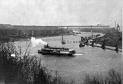
The North Saskatchewan also witnessed a lively, although short-lived, era of steamboat
shipping during the 1870s, 1880s, and 1890s. The Hudson's Bay Company
purchased a number of steamboats from companies operating on the Red River
and trading at Winnipeg
/Fort Garry
. The Company
desired to avoid paying the labour costs
of fur trade brigades
, and felt steamboat
shipping provided a suitable alternative. A number of HBC
steamboats did navigate the river intermittently over two decades, although fluctuating water levels and natural barriers (rapid
s and sandbars) hampered efficient operation of the HBC fleet. With the arrival of the railroad in Western Canada
, steamboat shipping on the Saskatchewan came to an end.
s have been planned and constructed on the North Saskatchewan River and its tributaries
. No singular purpose has dominated dam
planning in the basin, indeed, hydroelectric development
, flood control
, and water diversion schemes have all underpinned proposals to construct dams on the river.
Planned dams
The first hydroelectric development on the North Saskatchewan was planned in 1910 near the Town of Drayton Valley. Funding for the plan came from a British syndicate; design and construction were to be carried out by the Edmonton Hydro-Electric Power Scheme. The development was shelved after the outbreak of World War I.
The La Colle Falls hydroelectric project
east of Prince Albert was a half-built failure. Construction began in the 1910s and was later abandoned. The city remained in debt from financing the project until 1960, and the site still attracts tourists today.
During the 1960s and 1970s, a major dam was planned on the North Saskatchewan near the Hamlet
of Hairy Hill, Alberta
, about 100 miles (160.9 km) downstream from Edmonton
. This dam was part of a larger water diversion scheme conceived by the Alberta Government to transfer water from the Peace
, Smoky
, and Athabasca
rivers to the Saskatchewan River Basin
.
The planned dam had a maximum height of 212 feet (64.6 m), with a crest length of 5760 feet (1.8 km), which would have created a reservoir
capable of holding over 4000000 acre.ft of water. The reservoir
would have affected municipal water works in the City of Fort Saskatchewan
, was likely to inundate part of the Saddle Lake Indian Reserve
, and would have flooded a number of oil
and natural gas
fields in the area. The plan was later shelved in light of economic and environmental concerns.
Constructed dams
The Bighorn Dam
was constructed near Nordegg and created Lake Abraham, one of the largest reservoirs in Alberta. The dam was constructed in 1971 by Transalta
.
One of the North Saskatchewan's major tributaries, the Brazeau River
, houses the Brazeau Hydroelectric Dam. The Brazeau Dam is Alberta's largest hydroelectric facility, and was built in 1965 by Transalta
.
to Lake Abraham
Lake Abraham to Rocky Mountain House
Rocky Mountain House to Edmonton
Edmonton
to Alberta-Saskatchewan Border
Saskatchewan
Glacier
A glacier is a large persistent body of ice that forms where the accumulation of snow exceeds its ablation over many years, often centuries. At least 0.1 km² in area and 50 m thick, but often much larger, a glacier slowly deforms and flows due to stresses induced by its weight...
-fed river that flows east from the Canadian Rockies
Canadian Rockies
The Canadian Rockies comprise the Canadian segment of the North American Rocky Mountains range. They are the eastern part of the Canadian Cordillera, extending from the Interior Plains of Alberta to the Rocky Mountain Trench of British Columbia. The southern end borders Idaho and Montana of the USA...
to central Saskatchewan
Saskatchewan
Saskatchewan is a prairie province in Canada, which has an area of . Saskatchewan is bordered on the west by Alberta, on the north by the Northwest Territories, on the east by Manitoba, and on the south by the U.S. states of Montana and North Dakota....
. It is one of two major rivers that join to make up the Saskatchewan River
Saskatchewan River
The Saskatchewan River is a major river in Canada, approximately long, flowing roughly eastward across Saskatchewan and Manitoba to empty into Lake Winnipeg...
.
The Saskatchewan River system is the largest shared between the Canadian
Canada
Canada is a North American country consisting of ten provinces and three territories. Located in the northern part of the continent, it extends from the Atlantic Ocean in the east to the Pacific Ocean in the west, and northward into the Arctic Ocean...
provinces of Alberta
Alberta
Alberta is a province of Canada. It had an estimated population of 3.7 million in 2010 making it the most populous of Canada's three prairie provinces...
and Saskatchewan. It includes most of southern Alberta and southern Saskatchewan, before crossing into central Manitoba
Manitoba
Manitoba is a Canadian prairie province with an area of . The province has over 110,000 lakes and has a largely continental climate because of its flat topography. Agriculture, mostly concentrated in the fertile southern and western parts of the province, is vital to the province's economy; other...
.
Course
North Saskatchewan river has a length of 1,287 km (800 mi), and a drainage area of 122,800 km2. At its end point at Saskatchewan River ForksSaskatchewan River Forks
Saskatchewan River Forks refers to the area in Canada where the North Saskatchewan and South Saskatchewan rivers merge to create the Saskatchewan River...
it has a mean discharge of 245 m3/s. The yearly discharge at the Alberta/Saskatchewan border is more than 7 k m3.
The river begins above 1,800 metres at the toe of the Saskatchewan Glacier
Saskatchewan Glacier
Saskatchewan Glacier is located in Banff National Park, Alberta, Canada, approximately northwest of the town of Banff, and can be accessed from the Icefields Parkway. Saskatchewan Glacier is the largest outflow glacier from the Columbia Icefield, which rests along the Continental divide. The...
in the Columbia Icefield
Columbia Icefield
The Columbia Icefield is an icefield located in the Canadian Rockies, astride the Continental Divide of North America. The icefield lies partly in the northwestern tip of Banff National Park and the southern end of Jasper National Park. It is about 325 km² in area, 100 to 365 metres in depth and...
, and flows southeast through Banff National Park
Banff National Park
Banff National Park is Canada's oldest national park, established in 1885 in the Rocky Mountains. The park, located 110–180 kilometres west of Calgary in the province of Alberta, encompasses of mountainous terrain, with numerous glaciers and ice fields, dense coniferous forest, and alpine...
alongside the Icefields Parkway
Icefields Parkway
The Icefields Parkway , also known as Highway 93 north, is a scenic road in Alberta, Canada. It parallels the Continental Divide, traversing the rugged landscape of the Canadian Rockies, travelling through Banff National Park and Jasper National Park. It links Lake Louise with Jasper to the north....
. At the junction of the David Thompson Highway (Highway 11), it initially turns northeast for 10 kilometres before switching to a more direct eastern flow for about 30 km. At this point, it turns north where it eventually arrives at Abraham Lake
Abraham Lake
Abraham Lake is an artificial lake on North Saskatchewan River in western Alberta, Canada. Abraham Lake has a surface area of and a length of .-History:...
. Bighorn Dam
Bighorn Dam
Bighorn Dam is a dam located in Clearwater County in west-central Alberta, Canada. It was built by TransAlta Corporation in 1972, and lead to the creation of Lake Abraham, Alberta's largest man-made lake....
constricts the north end of Abraham Lake, where the North Saskatchewan emerges to track eastward to Rocky Mountain House. At Rocky Mountain House, the river abruptly turns north again for 100 km where it switches east towards Edmonton, Alberta. In Edmonton, the river passes through the centre of the city in a northeasterly direction and out towards Smoky Lake
Smoky Lake, Alberta
Smoky Lake is a town in central Alberta, Canada. It is located northeast of Edmonton at the junction of Highway 28 and Highway 855. It lies between the North Saskatchewan River, Smoky Creek and White Earth Creek. Long Lake Provincial Park is located north of the town.- Demographics :In 2006,...
at which point it quickly changes to the southeast and then more to the east as it makes it way to the Alberta–Saskatchewan boundary.
From the border, the river flows southeast between North Battleford
North Battleford, Saskatchewan
In the late 2000s a large number of Ruthenians have emigrated to Canada, concentrating in North Battleford.-History:Prior to European settlement, the Battlefords area was home to several aboriginal groups...
and Battleford and on in the direction of Saskatoon. About 40 km northwest of Saskatoon, near Langham
Langham, Saskatchewan
-Neighboring Communities:Rural Saskatchewan is known for the support that communities give each other in the form of attending community activities, sharing sport teams, and building friendships among children and adults from neighboring towns and cities. Communities that surround Langham include...
, the river veers to the northeast where it passes through the City of Prince Albert
Prince Albert, Saskatchewan
Prince Albert is the third-largest city in Saskatchewan, Canada. It is situated in the centre of the province on the banks of the North Saskatchewan River. The city is known as the "Gateway to the North" because it is the last major centre along the route to the resources of northern Saskatchewan...
. About 30 km downstream of Prince Albert, the North Saskatchewan River joins the South Saskatchewan River
South Saskatchewan River
The South Saskatchewan River is a major river in Canada that flows through the provinces of Alberta and Saskatchewan....
at Saskatchewan River Forks
Saskatchewan River Forks
Saskatchewan River Forks refers to the area in Canada where the North Saskatchewan and South Saskatchewan rivers merge to create the Saskatchewan River...
to become the Saskatchewan River. From here, the river flows east to Tobin Lake
Tobin Lake
Tobin Lake is a reservoir of Saskatchewan, Canada. Tobin Lake was formed by the E.B. Campbell Dam on the Saskatchewan River in 1963. The dam was originally named Squaw Rapids Dam, but was then renamed E.B. Campbell Dam due to the local first nations people who considered the name Squaw Rapids...
and into Manitoba
Manitoba
Manitoba is a Canadian prairie province with an area of . The province has over 110,000 lakes and has a largely continental climate because of its flat topography. Agriculture, mostly concentrated in the fertile southern and western parts of the province, is vital to the province's economy; other...
, eventually emptying into Lake Winnipeg
Lake Winnipeg
Lake Winnipeg is a large, lake in central North America, in the province of Manitoba, Canada, with its southern tip about north of the city of Winnipeg...
.
Geography
Rocky Mountains
The Rocky Mountains are a major mountain range in western North America. The Rocky Mountains stretch more than from the northernmost part of British Columbia, in western Canada, to New Mexico, in the southwestern United States...
, is the smallest area geographically, although the largest in terms of run-off and contributed water flow. The glaciers and perpetual snows of the mountain peaks feed the river year-round. Mountains, with little vegetation, experience fast-melting snow cover. The second section of the river comprises the foothills region
Foothills
Foothills are geographically defined as gradual increases in elevation at the base of a mountain range. They are a transition zone between plains and low relief hills to the adjacent topographically high mountains.-Examples:...
. The terrain is hilly and rough, with a deeper and more defined valley. This area is well covered with forest and muskeg
Muskeg
Muskeg is an acidic soil type common in Arctic and boreal areas, although it is found in other northern climates as well. Muskeg is approximately synonymous with bogland but muskeg is the standard term in Western Canada and Alaska, while 'bog' is common elsewhere. The term is of Cree origin, maskek...
, and run-off into the river is much more constant and stable than in the mountains.
From Edmonton
Edmonton
Edmonton is the capital of the Canadian province of Alberta and is the province's second-largest city. Edmonton is located on the North Saskatchewan River and is the centre of the Edmonton Capital Region, which is surrounded by the central region of the province.The city and its census...
to the mouth of the Vermilion River
Vermilion River (Alberta)
The Vermilion River is located in east-central Alberta, Canada. Its lower course flows through Vermilion River County, which is named after this river. It is a tributary of the North Saskatchewan River.-Course:...
, the North Saskatchewan flows through the plains-parkland
Aspen parkland
Aspen parkland refers to a very large area of transitional biome between prairie and boreal forest in two sections; the Peace River Country of northwestern Alberta crossing the border into British Columbia, and a much larger area stretching from central Alberta, all across central Saskatchewan to...
divide, with occasional stretches of prairie
Prairie
Prairies are considered part of the temperate grasslands, savannas, and shrublands biome by ecologists, based on similar temperate climates, moderate rainfall, and grasses, herbs, and shrubs, rather than trees, as the dominant vegetation type...
. Here the river runs in a well-defined valley with deep cuts in the landscape. The fourth section, from the Vermilion River
Vermilion River (Alberta)
The Vermilion River is located in east-central Alberta, Canada. Its lower course flows through Vermilion River County, which is named after this river. It is a tributary of the North Saskatchewan River.-Course:...
to Prince Albert
Prince Albert, Saskatchewan
Prince Albert is the third-largest city in Saskatchewan, Canada. It is situated in the centre of the province on the banks of the North Saskatchewan River. The city is known as the "Gateway to the North" because it is the last major centre along the route to the resources of northern Saskatchewan...
is principally prairie
Prairie
Prairies are considered part of the temperate grasslands, savannas, and shrublands biome by ecologists, based on similar temperate climates, moderate rainfall, and grasses, herbs, and shrubs, rather than trees, as the dominant vegetation type...
with a few small stretches of timber and secondary forest cover. The valley of the river is much wider, and the river itself spreads out across shallow water and flows over many shifting sand bars
Shoal
Shoal, shoals or shoaling may mean:* Shoal, a sandbank or reef creating shallow water, especially where it forms a hazard to shipping* Shoal draught , of a boat with shallow draught which can pass over some shoals: see Draft...
. Low-lying, flat areas, border the river for much of this section.
The final section of the river, from Prince Albert
Prince Albert, Saskatchewan
Prince Albert is the third-largest city in Saskatchewan, Canada. It is situated in the centre of the province on the banks of the North Saskatchewan River. The city is known as the "Gateway to the North" because it is the last major centre along the route to the resources of northern Saskatchewan...
to the Forks
Saskatchewan River
The Saskatchewan River is a major river in Canada, approximately long, flowing roughly eastward across Saskatchewan and Manitoba to empty into Lake Winnipeg...
, has many rapid
Rapid
A rapid is a section of a river where the river bed has a relatively steep gradient causing an increase in water velocity and turbulence. A rapid is a hydrological feature between a run and a cascade. A rapid is characterised by the river becoming shallower and having some rocks exposed above the...
s. The valley is more shallow than the previous sections of the river, and the channel is much better defined. There is little prairie and much tree cover in this section.
Geology
The Bridge River AshBridge River Ash
The Bridge River Ash is a large geologically recent volcanic ash deposit that spans from southwestern British Columbia to central Alberta, Canada. The ash consists of dust-sized shards ellipsoidal fragments of pumice. It overlaps the Mount St. Helens Yn Ash and the Mazama Ash which were erupted...
is in the vicinity of the North Saskatchewan River, which erupted from Mount Meager
Mount Meager
Mount Meager, originally known as Meager Mountain, is a complex volcano in the Sea-to-Sky Corridor of southwestern British Columbia, Canada. It is located north of Vancouver at the northern end of the Pemberton Valley. Part of the Cascade Volcanic Arc of western North America, its summit is above...
in southwestern British Columbia
British Columbia
British Columbia is the westernmost of Canada's provinces and is known for its natural beauty, as reflected in its Latin motto, Splendor sine occasu . Its name was chosen by Queen Victoria in 1858...
about 2350 years ago.
History
Canadian Heritage Rivers System
The Canadian Heritage Rivers System was established in 1984 by the federal, provincial and territorial governments to conserve and protect the best examples of Canada's river heritage, to give them national recognition, and to encourage the public to enjoy and appreciate them. It is a cooperative...
in 1989, for its importance in the development of western Canada
Canadian Prairies
The Canadian Prairies is a region of Canada, specifically in western Canada, which may correspond to several different definitions, natural or political. Notably, the Prairie provinces or simply the Prairies comprise the provinces of Alberta, Saskatchewan, and Manitoba, as they are largely covered...
.
The river bridges the plains
Prairie
Prairies are considered part of the temperate grasslands, savannas, and shrublands biome by ecologists, based on similar temperate climates, moderate rainfall, and grasses, herbs, and shrubs, rather than trees, as the dominant vegetation type...
–parkland
Aspen parkland
Aspen parkland refers to a very large area of transitional biome between prairie and boreal forest in two sections; the Peace River Country of northwestern Alberta crossing the border into British Columbia, and a much larger area stretching from central Alberta, all across central Saskatchewan to...
divide for much of its course, acting as a natural boundary between Blackfoot
Blackfoot
The Blackfoot Confederacy or Niitsítapi is the collective name of three First Nations in Alberta and one Native American tribe in Montana....
and Cree
Cree
The Cree are one of the largest groups of First Nations / Native Americans in North America, with 200,000 members living in Canada. In Canada, the major proportion of Cree live north and west of Lake Superior, in Ontario, Manitoba, Saskatchewan, Alberta and the Northwest Territories, although...
First Nations people
First Nations
First Nations is a term that collectively refers to various Aboriginal peoples in Canada who are neither Inuit nor Métis. There are currently over 630 recognised First Nations governments or bands spread across Canada, roughly half of which are in the provinces of Ontario and British Columbia. The...
for thousands of years. With the westward expansion of the fur trade
Fur trade
The fur trade is a worldwide industry dealing in the acquisition and sale of animal fur. Since the establishment of world market for in the early modern period furs of boreal, polar and cold temperate mammalian animals have been the most valued...
under the North West Company
North West Company
The North West Company was a fur trading business headquartered in Montreal from 1779 to 1821. It competed with increasing success against the Hudson's Bay Company in what was to become Western Canada...
, the river became a natural transportation route for fur trade brigades. A number of fur trade posts were constructed on the river, including Fort Edmonton
Fort Edmonton
Fort Edmonton was the name of a series of trading posts of the Hudson's Bay Company from 1795 to 1891, all of which were located in central Alberta, Canada...
and Rocky Mountain House, the uppermost post reached by canoe navigation. After the amalgamation of the Hudson's Bay Company
Hudson's Bay Company
The Hudson's Bay Company , abbreviated HBC, or "The Bay" is the oldest commercial corporation in North America and one of the oldest in the world. A fur trading business for much of its existence, today Hudson's Bay Company owns and operates retail stores throughout Canada...
and the North West Company
North West Company
The North West Company was a fur trading business headquartered in Montreal from 1779 to 1821. It competed with increasing success against the Hudson's Bay Company in what was to become Western Canada...
, the North Saskatchewan was a main travel route for York boats. Finally, before the arrival of the railway in western Canada, the river was plied by a number of steamboats.
Recreation
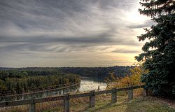
Edmonton's North Saskatchewan River valley parks systemNorth Saskatchewan River valley parks system
The North Saskatchewan River valley parks system is a continuous collection of urban parks in the North Saskatchewan River valley of Edmonton, Alberta....
is the largest system of urban parks in North America, and covers both sides of the river valley's course through Edmonton.
Fish species
FishFish
Fish are a paraphyletic group of organisms that consist of all gill-bearing aquatic vertebrate animals that lack limbs with digits. Included in this definition are the living hagfish, lampreys, and cartilaginous and bony fish, as well as various extinct related groups...
species include: walleye
Walleye
Walleye is a freshwater perciform fish native to most of Canada and to the northern United States. It is a North American close relative of the European pikeperch...
, sauger
Sauger
The sauger is a freshwater perciform fish of the family Percidae which resembles its close relative the walleye. They are members of the largest vertebrate order, Perciforms. They are the most migratory percid species in North America. Saugers obtain two dorsal fins, the first is spiny and the...
, yellow perch
Yellow perch
The yellow perch is a species of perch found in the United States and Canada, where it is often referred to by the shortform perch. Yellow perch look similar to the European perch, but are paler and more yellowish, with less red in the fins. They have six to eight dark, vertical bars on their sides...
, northern pike
Northern Pike
The northern pike , is a species of carnivorous fish of the genus Esox...
, goldeye
Goldeye
The goldeye, Hiodon alosoides, is a species of fish in the mooneye family . It occurs from as far down the Mackenzie River as Aklavik in the north to Mississippi in the south, and from Alberta in the west to Ohio south of the Great Lakes, with an isolated population south of James Bay. It is...
, mooneye
Mooneye
The mooneyes are a family, the Hiodontidae, of primitive ray-finned fish comprising two living and three extinct species in the genus Hiodon. They are large-eyed, fork-tailed fish that physically resemble shads. Their common name comes from the metallic gold or silver shine of their eyes.The higher...
, lake sturgeon
Lake sturgeon
The lake sturgeon is a North American temperate freshwater fish, one of about 20 species of sturgeon. Like other sturgeons, this species is an evolutionarily ancient bottomfeeder with a partly cartilaginous skeleton and skin bearing rows of bony plates...
, burbot
Burbot
The burbot is the only gadiform fish inhabiting freshwaters. It is also known as mariah, the lawyer, and eelpout. It is closely related to the marine common ling and the cusk...
, longnose sucker
Longnose sucker
The longnose sucker, Catostomus catostomus, is a freshwater species of fish inhabiting cold, clear waters in North America from northern USA to the top of the continent. In addition, it is one of two species of sucker to inhabit Asia, specifically the rivers of eastern Siberia...
, white sucker
White Sucker
The White Sucker is a bottom-feeding freshwater fish inhabiting North America from Labrador in the north to Georgia and New Mexico in the south. It is a long, round-bodied fish with a dark green, grey, copper, brown, or black back and sides and a light underbelly. When fullgrown, it is between 12...
and shorthead redhorse
Shorthead redhorse
-Introduction:The Shorthead Redhorse is a wide-ranging species in North America that needs to be monitored throughout its range. The Shorthead Redhorse is native to central and eastern North America. However, its range has expanded to include areas like the Hudson estuary and Grayson County, Texas...
.
Flooding
Like all rivers, the North Saskatchewan is subject to periodic flooding, beginning with rapid snowmelt in the mountainsCanadian Rockies
The Canadian Rockies comprise the Canadian segment of the North American Rocky Mountains range. They are the eastern part of the Canadian Cordillera, extending from the Interior Plains of Alberta to the Rocky Mountain Trench of British Columbia. The southern end borders Idaho and Montana of the USA...
or prolonged periods of rain in the river basin. With the establishment of permanent communities along the river's course, and the rise of an administrative/government structure, records
Public records
Public records are documents or pieces of information that are not considered confidential. For example, in California, when a couple fills out a marriage license application, they have the option of checking the box as to whether the marriage is "confidential" or "Public"...
exist recording floods in the North Saskatchewan for the past century. The Bighorn Dam
Bighorn Dam
Bighorn Dam is a dam located in Clearwater County in west-central Alberta, Canada. It was built by TransAlta Corporation in 1972, and lead to the creation of Lake Abraham, Alberta's largest man-made lake....
, constructed in the early 1970s near Nordegg, Alberta
Nordegg, Alberta
Nordegg is a hamlet in west-central Alberta, Canada within Clearwater County. It is located in the North Saskatchewan River valley in the foothills of the Canadian Rockies, at the crossroads of David Thompson Highway and the Highway 734 spur of the Bighorn Highway.- History :The community was...
, and the Brazeau Dam, constructed in the mid-1960s, have both dramatically reduced occurrences of flooding in the North Saskatchewan River.
| Year | Edmonton Edmonton Edmonton is the capital of the Canadian province of Alberta and is the province's second-largest city. Edmonton is located on the North Saskatchewan River and is the centre of the Edmonton Capital Region, which is surrounded by the central region of the province.The city and its census... |
Prince Albert Prince Albert, Saskatchewan Prince Albert is the third-largest city in Saskatchewan, Canada. It is situated in the centre of the province on the banks of the North Saskatchewan River. The city is known as the "Gateway to the North" because it is the last major centre along the route to the resources of northern Saskatchewan... |
||
|---|---|---|---|---|
| Peak date | Peak flow (m³/s) |
Peak date | Peak flow (m³/s) |
|
| 1915 | 29 June | 4640 | 2 July | 5300 |
| 1923 | 25 June | 2380 | 30 June | 1640 |
| 1944 | 16 June | 3450 | – | – |
| 1952 | 25 June | 3540 | 29 June | 2970 |
| 1954 | 8 June | 3030 | 12 June | 2790 |
| 1965 | 29 June | 2590 | 4 July | 2460 |
| 1972 | 27 June | 2970 | 2 July | 2340 |
| 1986 | 19 July | 3990 | 24 July | 3230 |
| 1990 | 4 July | 2340 | 10 July | 1890 |
| 2005 | 21 June | 2270 | 27 June | 1800 |
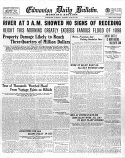
The flood of 1915
The 1915 flood of the North Saskatchewan River was one of the most dramatic in the history of Edmonton
Edmonton
Edmonton is the capital of the Canadian province of Alberta and is the province's second-largest city. Edmonton is located on the North Saskatchewan River and is the centre of the Edmonton Capital Region, which is surrounded by the central region of the province.The city and its census...
. On 28 June, the Edmonton Bulletin
Edmonton Bulletin
The Edmonton Bulletin was a newspaper in Edmonton, Alberta published from 1880 until January 20, 1951. It was founded by Frank Oliver, a politician and future minister in the Canadian Government....
reported the river had risen "10 feet in as many hours." A frantic phone call from Rocky Mountain House alerted local authorities to the flood's arrival. The Canadian Northern Railway
Canadian Northern Railway
The Canadian Northern Railway is a historic Canadian transcontinental railway. At its demise in 1923, when it was merged into the Canadian National Railway , the CNoR owned a main line between Quebec City and Vancouver via Ottawa, Winnipeg, and Edmonton.-Manitoba beginnings:CNoR had its start in...
had parked a number of train cars on the city's Low Level Bridge to protect against the "tons upon tons of debris" that had been pushed up against its piers, including a house swept away by the current. Thousands of Edmonton residents watched the flood destroy lumber mills along the city's river valley.
Commercial navigation
The North Saskatchewan River has always been a major trade routeTrade route
A trade route is a logistical network identified as a series of pathways and stoppages used for the commercial transport of cargo. Allowing goods to reach distant markets, a single trade route contains long distance arteries which may further be connected to several smaller networks of commercial...
from Hudson Bay
Hudson Bay
Hudson Bay , sometimes called Hudson's Bay, is a large body of saltwater in northeastern Canada. It drains a very large area, about , that includes parts of Ontario, Quebec, Saskatchewan, Alberta, most of Manitoba, southeastern Nunavut, as well as parts of North Dakota, South Dakota, Minnesota,...
and central Canada across the plains
Canadian Prairies
The Canadian Prairies is a region of Canada, specifically in western Canada, which may correspond to several different definitions, natural or political. Notably, the Prairie provinces or simply the Prairies comprise the provinces of Alberta, Saskatchewan, and Manitoba, as they are largely covered...
and towards the Rocky Mountains
Canadian Rockies
The Canadian Rockies comprise the Canadian segment of the North American Rocky Mountains range. They are the eastern part of the Canadian Cordillera, extending from the Interior Plains of Alberta to the Rocky Mountain Trench of British Columbia. The southern end borders Idaho and Montana of the USA...
. During the fur trade
Fur trade
The fur trade is a worldwide industry dealing in the acquisition and sale of animal fur. Since the establishment of world market for in the early modern period furs of boreal, polar and cold temperate mammalian animals have been the most valued...
era, birch bark
Birch bark
Birch bark or birchbark is the bark of several Eurasian and North American birch trees of the genus Betula.The strong and water-resistant cardboard-like bark can be easily cut, bent, and sewn, which made it a valuable building, crafting, and writing material, since pre-historic times...
canoe
Canoe
A canoe or Canadian canoe is a small narrow boat, typically human-powered, though it may also be powered by sails or small electric or gas motors. Canoes are usually pointed at both bow and stern and are normally open on top, but can be decked over A canoe (North American English) or Canadian...
s and York boat
York boat
The York boat was an inland boat used by the Hudson's Bay Company to carry furs and trade goods along inland waterways in Rupert's Land and the Columbia District. It was named after York Factory, the headquarters of the HBC, and modeled after Orkney Islands fishing boats...
s travelled up and down the Saskatchewan delivering trade goods and amassing furs for transportation to Europe.
The North Saskatchewan also witnessed a lively, although short-lived, era of steamboat
Steamboat
A steamboat or steamship, sometimes called a steamer, is a ship in which the primary method of propulsion is steam power, typically driving propellers or paddlewheels...
shipping during the 1870s, 1880s, and 1890s. The Hudson's Bay Company
Hudson's Bay Company
The Hudson's Bay Company , abbreviated HBC, or "The Bay" is the oldest commercial corporation in North America and one of the oldest in the world. A fur trading business for much of its existence, today Hudson's Bay Company owns and operates retail stores throughout Canada...
purchased a number of steamboats from companies operating on the Red River
Red River of the North
The Red River is a North American river. Originating at the confluence of the Bois de Sioux and Otter Tail rivers in the United States, it flows northward through the Red River Valley and forms the border between the U.S. states of Minnesota and North Dakota before continuing into Manitoba, Canada...
and trading at Winnipeg
Winnipeg
Winnipeg is the capital and largest city of Manitoba, Canada, and is the primary municipality of the Winnipeg Capital Region, with more than half of Manitoba's population. It is located near the longitudinal centre of North America, at the confluence of the Red and Assiniboine Rivers .The name...
/Fort Garry
Fort Garry
Fort Garry, also known as Upper Fort Garry, was a Hudson's Bay Company trading post at the confluence of the Red and Assiniboine rivers in what is now downtown Winnipeg. It was established in 1822 on or near the site of the North West Company's Fort Gibraltar. Fort Garry was named after Nicholas...
. The Company
Hudson's Bay Company
The Hudson's Bay Company , abbreviated HBC, or "The Bay" is the oldest commercial corporation in North America and one of the oldest in the world. A fur trading business for much of its existence, today Hudson's Bay Company owns and operates retail stores throughout Canada...
desired to avoid paying the labour costs
Wage
A wage is a compensation, usually financial, received by workers in exchange for their labor.Compensation in terms of wages is given to workers and compensation in terms of salary is given to employees...
of fur trade brigades
Fur brigade
The Fur brigade were convoys of Canadian Indian fur trappers who traveled between their home trading posts and a larger HBC post in order to supply the inland post with goods and supply the HBC post with furs. Travel was usually done on the rivers by canoe or, in certain prairie situations, by horse...
, and felt steamboat
Steamboat
A steamboat or steamship, sometimes called a steamer, is a ship in which the primary method of propulsion is steam power, typically driving propellers or paddlewheels...
shipping provided a suitable alternative. A number of HBC
Hudson's Bay Company
The Hudson's Bay Company , abbreviated HBC, or "The Bay" is the oldest commercial corporation in North America and one of the oldest in the world. A fur trading business for much of its existence, today Hudson's Bay Company owns and operates retail stores throughout Canada...
steamboats did navigate the river intermittently over two decades, although fluctuating water levels and natural barriers (rapid
Rapid
A rapid is a section of a river where the river bed has a relatively steep gradient causing an increase in water velocity and turbulence. A rapid is a hydrological feature between a run and a cascade. A rapid is characterised by the river becoming shallower and having some rocks exposed above the...
s and sandbars) hampered efficient operation of the HBC fleet. With the arrival of the railroad in Western Canada
Western Canada
Western Canada, also referred to as the Western provinces and commonly as the West, is a region of Canada that includes the four provinces west of the province of Ontario.- Provinces :...
, steamboat shipping on the Saskatchewan came to an end.
Dams and hydroelectric development
A number of damDam
A dam is a barrier that impounds water or underground streams. Dams generally serve the primary purpose of retaining water, while other structures such as floodgates or levees are used to manage or prevent water flow into specific land regions. Hydropower and pumped-storage hydroelectricity are...
s have been planned and constructed on the North Saskatchewan River and its tributaries
Tributary
A tributary or affluent is a stream or river that flows into a main stem river or a lake. A tributary does not flow directly into a sea or ocean...
. No singular purpose has dominated dam
Dam
A dam is a barrier that impounds water or underground streams. Dams generally serve the primary purpose of retaining water, while other structures such as floodgates or levees are used to manage or prevent water flow into specific land regions. Hydropower and pumped-storage hydroelectricity are...
planning in the basin, indeed, hydroelectric development
Hydroelectricity
Hydroelectricity is the term referring to electricity generated by hydropower; the production of electrical power through the use of the gravitational force of falling or flowing water. It is the most widely used form of renewable energy...
, flood control
Flood
A flood is an overflow of an expanse of water that submerges land. The EU Floods directive defines a flood as a temporary covering by water of land not normally covered by water...
, and water diversion schemes have all underpinned proposals to construct dams on the river.
Planned dams
The first hydroelectric development on the North Saskatchewan was planned in 1910 near the Town of Drayton Valley. Funding for the plan came from a British syndicate; design and construction were to be carried out by the Edmonton Hydro-Electric Power Scheme. The development was shelved after the outbreak of World War I.
The La Colle Falls hydroelectric project
LaColle Falls Hydroelectric Dam
LaColle Falls Hydroelectric Dam is a partially complete hydroelectric dam built by the City of Prince Albert, Saskatchewan. The dam is located on the North Saskatchewan river approximately 45 kilometres east of the city in an area that inaccessible. Construction started in 1909 and the partially...
east of Prince Albert was a half-built failure. Construction began in the 1910s and was later abandoned. The city remained in debt from financing the project until 1960, and the site still attracts tourists today.
During the 1960s and 1970s, a major dam was planned on the North Saskatchewan near the Hamlet
Hamlet (place)
A hamlet is usually a rural settlement which is too small to be considered a village, though sometimes the word is used for a different sort of community. Historically, when a hamlet became large enough to justify building a church, it was then classified as a village...
of Hairy Hill, Alberta
Hairy Hill, Alberta
Hairy Hill is a hamlet in Alberta, Canada within the County of Two Hills No. 21. It is located on Highway 45, approximately east of Edmonton.- References :...
, about 100 miles (160.9 km) downstream from Edmonton
Edmonton
Edmonton is the capital of the Canadian province of Alberta and is the province's second-largest city. Edmonton is located on the North Saskatchewan River and is the centre of the Edmonton Capital Region, which is surrounded by the central region of the province.The city and its census...
. This dam was part of a larger water diversion scheme conceived by the Alberta Government to transfer water from the Peace
Peace River (Canada)
The Peace River is a river in Canada that originates in the Rocky Mountains of northern British Columbia and flows to the northeast through northern Alberta. The Peace River flows into the Slave River, a tributary of the Mackenzie River. The Mackenzie is the 12th longest river in the world,...
, Smoky
Smoky River
Smoky River is a river in western Alberta, Canada. It is a major tributary of the Peace River. The descriptive name refers to the presence of "smouldering beds of coal in the riverbank" noted by the Cree Indians....
, and Athabasca
Athabasca River
The Athabasca River originates from the Columbia Glacier of the Columbia Icefield in Jasper National Park in Alberta, Canada...
rivers to the Saskatchewan River Basin
Saskatchewan River
The Saskatchewan River is a major river in Canada, approximately long, flowing roughly eastward across Saskatchewan and Manitoba to empty into Lake Winnipeg...
.
The planned dam had a maximum height of 212 feet (64.6 m), with a crest length of 5760 feet (1.8 km), which would have created a reservoir
Reservoir
A reservoir , artificial lake or dam is used to store water.Reservoirs may be created in river valleys by the construction of a dam or may be built by excavation in the ground or by conventional construction techniques such as brickwork or cast concrete.The term reservoir may also be used to...
capable of holding over 4000000 acre.ft of water. The reservoir
Reservoir
A reservoir , artificial lake or dam is used to store water.Reservoirs may be created in river valleys by the construction of a dam or may be built by excavation in the ground or by conventional construction techniques such as brickwork or cast concrete.The term reservoir may also be used to...
would have affected municipal water works in the City of Fort Saskatchewan
Fort Saskatchewan, Alberta
Fort Saskatchewan is a city in Alberta, Canada, located northeast of downtown Edmonton, Alberta's capital city, along the North Saskatchewan River. Fort Saskatchewan is part of the Edmonton Census Metropolitan Area and is one of 24 municipalities on the Capital Region Board...
, was likely to inundate part of the Saddle Lake Indian Reserve
Indian reserve
In Canada, an Indian reserve is specified by the Indian Act as a "tract of land, the legal title to which is vested in Her Majesty, that has been set apart by Her Majesty for the use and benefit of a band." The Act also specifies that land reserved for the use and benefit of a band which is not...
, and would have flooded a number of oil
Oil
An oil is any substance that is liquid at ambient temperatures and does not mix with water but may mix with other oils and organic solvents. This general definition includes vegetable oils, volatile essential oils, petrochemical oils, and synthetic oils....
and natural gas
Natural gas
Natural gas is a naturally occurring gas mixture consisting primarily of methane, typically with 0–20% higher hydrocarbons . It is found associated with other hydrocarbon fuel, in coal beds, as methane clathrates, and is an important fuel source and a major feedstock for fertilizers.Most natural...
fields in the area. The plan was later shelved in light of economic and environmental concerns.
Constructed dams
The Bighorn Dam
Bighorn Dam
Bighorn Dam is a dam located in Clearwater County in west-central Alberta, Canada. It was built by TransAlta Corporation in 1972, and lead to the creation of Lake Abraham, Alberta's largest man-made lake....
was constructed near Nordegg and created Lake Abraham, one of the largest reservoirs in Alberta. The dam was constructed in 1971 by Transalta
TransAlta
TransAlta Corporation is a power generation and wholesale marketing company headquartered in Calgary, Alberta.TransAlta maintains a low-to-moderate risk profile by operating a highly contracted portfolio of assets in Canada, the United States and Australia...
.
One of the North Saskatchewan's major tributaries, the Brazeau River
Brazeau River
The Brazeau River is a river in western Alberta, Canada. It is a major tributary of the North Saskatchewan River.The river was named for Joseph Brazeau, a linguist associated with the Palliser Expedition.-Course:...
, houses the Brazeau Hydroelectric Dam. The Brazeau Dam is Alberta's largest hydroelectric facility, and was built in 1965 by Transalta
TransAlta
TransAlta Corporation is a power generation and wholesale marketing company headquartered in Calgary, Alberta.TransAlta maintains a low-to-moderate risk profile by operating a highly contracted portfolio of assets in Canada, the United States and Australia...
.
Tributaries
Saskatchewan GlacierSaskatchewan Glacier
Saskatchewan Glacier is located in Banff National Park, Alberta, Canada, approximately northwest of the town of Banff, and can be accessed from the Icefields Parkway. Saskatchewan Glacier is the largest outflow glacier from the Columbia Icefield, which rests along the Continental divide. The...
to Lake Abraham
- Nigel CreekNigel CreekNigel Creek is a short stream located in the Canadian Rockies of Alberta, Canada. It forms in the glacial meltwaters north of Sunwapta Pass and takes on streams flowing from Nigel Pass....
- Alexandra River
- Norman Creek
- Rampart Creek
- Arctomy's Creek
- Castleguard River
- Howse RiverHowse RiverHowse River is a short river in western Alberta, Canada. It is a tributary of the North Saskatchewan River.Howse River is a corded river, with several streams crossing in its flood plain...
- Glacier River
- Mistaya RiverMistaya RiverMistaya River is a short river in western Alberta, Canada. It flows through the Canadian Rockies, and a section of the Icefield Parkway was built along its course....
- Peyto Lake
- Owen Creek
- Thompson Creek
- Corona Creek
- Spreading Creek
- Wildhorse Creek
- Loudon Creek
- Siffleur RiverSiffleur RiverThe Siffleur River is a short river rising in the Canadian Rockies in western Alberta. The Siffleur River is an early tributary of the North Saskatchewan River....
- Escarpment River
- Two O'Clock Creek
- Bridge Creek
- Whiterabbit Creek
Lake Abraham to Rocky Mountain House
- Canyon Creek
- Cline RiverCline RiverThe Cline River is a short river in western Alberta, Canada. It flows from Pinto Lake in northern Banff National Park, and joins the North Saskatchewan River at Lake Abraham in west-central Alberta....
- Pinto Lake
- Whitegoat Creek
- BATUS Creek
- Hoodoo Creek
- Allstones Creek
- Mud Creek
- Tershishner Creek
- Crooked Creek
- Kidd Creek
- Bighorn RiverBighorn River (Alberta)The Bighorn River is a short river originating in the Alberta foothills, and is a tributary of the North Saskatchewan River. The river, as well as the nearby Bighorn Range and Bighorn Dam are named for the Bighorn sheep which dominate the area...
- Black Canyon Creek
- South Creek
- Dutch Creek
- Jock Creek
- Gap Creek
- Deep Creek
- Shunda Creek
- Jack Fish Creek
- Camp Creek
- Lundine Creek
- Lewis Creek
- Rough Creek
- Ram RiverRam RiverThe Ram River is a significant river rising in the Alberta Rocky Mountains. It flows westward, taking on the North Ram River, before joining the North Saskatchewan River near the town of Rocky Mountain House, Alberta. The name Ram Rivulet appears on a David Thompson map of 1814...
- North Ram River
- Cow Creek
- Cow Lake
- Clearwater RiverClearwater River, AlbertaClearwater is a river of southern Alberta, Canada. Situated entirely in the Canadian Rockies and the Rocky Mountain foothills of Alberta, it is a glacier fed upper reach tributary of the North Saskatchewan River...
Rocky Mountain House to Edmonton
Edmonton
Edmonton is the capital of the Canadian province of Alberta and is the province's second-largest city. Edmonton is located on the North Saskatchewan River and is the centre of the Edmonton Capital Region, which is surrounded by the central region of the province.The city and its census...
- Chicken Creek
- Little Beaver Creek
- Big Beaver Creek
- No Name Creek
- Baptiste River
- Brazeau RiverBrazeau RiverThe Brazeau River is a river in western Alberta, Canada. It is a major tributary of the North Saskatchewan River.The river was named for Joseph Brazeau, a linguist associated with the Palliser Expedition.-Course:...
- Southesk River, Cardinal RiverCardinal RiverCardinal River is a short river in western Alberta, Canada. It flows from the Canadian Rockies, and empties into the Brazeau River, itself a major tributary of the North Saskatchewan River....
, Blackstone River, Elk RiverElk River (Alberta)The Elk River is a short river rising in the eastern portion of the Alberta foothills. The river begins south of the ghost town of Coalspur and heads East before draining into the Brazeau Reservoir created by the Brazeau Dam on the Brazeau River, a tributary of the North Saskatchewan River.The...
, Nordegg River
- Southesk River, Cardinal River
- Sand Creek
- Wolf Creek
- Washout Creek
- Mishow Creek
- Poplar Modeste Creek
- Tomahawk Creek
- Shoal Lakes Creek
- Wabamum Creek
- Wabamum Lake
- Strawberry Creek
- Weed Creek
- Willow Creek
- Cutbank Creek
- Conjuring Creek
- Wizard Lake
- Whitemud CreekWhitemud CreekWhitemud Creek is a creek in central Alberta that flows into the North Saskatchewan River.For part of its length, the creek flows through the city of Edmonton, Alberta, Canada. It separates neighbourhoods in the Riverbend and Terwillegar areas from other neighbourhoods on the south side of the...
- Blackmud CreekBlackmud CreekBlackmud Creek is a creek in Edmonton that flows into Whitemud Creek. It separates from Whitemud Creek in the neighborhood of Twin Brooks. It continues south of the city, then comes around the east of Nisku and runs into Coal Lake....
- Mill Creek RavineMill Creek RavineMill Creek Ravine is located in south Edmonton, Alberta, Canada. The north end of the ravine opens onto the North Saskatchewan River valley near the west end of Cloverdale and then approaches the Low Level and the James McDonald bridges...
Edmonton
Edmonton
Edmonton is the capital of the Canadian province of Alberta and is the province's second-largest city. Edmonton is located on the North Saskatchewan River and is the centre of the Edmonton Capital Region, which is surrounded by the central region of the province.The city and its census...
to Alberta-Saskatchewan Border
- Rat Creek
- Oldman Creek
- Horsehills Creek
- Ross Creek
- Sturgeon RiverSturgeon River (Alberta)Sturgeon River is a 260 km long river located in central Alberta, Canada. It is a major tributary of the North Saskatchewan River. The stream crosses Sturgeon County, which was named for this river....
- Big Lake
- Redwater River
- Beaverhill Creek
- Waskatenau Creek
- Egg Creek
- Smoky Creek
- White Earth Creek
- Redclay Creek
- Cucumber Creek
- Saddlelake Creek
- Lake Eliza Creek
- Siler Creek
- Gideon Lake
- Death River
- Antimose Creek
- Telegraph Creek
- Moosehills Creek
- Mooswa Creek
- Middle Creek
- Borden Lake, Laurier Lake, Ross Lake, Whitney Lake
- Frog Creek
- Alma Creek
- Vermilion RiverVermilion River (Alberta)The Vermilion River is located in east-central Alberta, Canada. Its lower course flows through Vermilion River County, which is named after this river. It is a tributary of the North Saskatchewan River.-Course:...
- Chester Creek
- Two Hills Creek
- Cabin Lake
- Mosquito Creek
Saskatchewan
- Pipestone Creek
- Oldman Creek
- Monnery River
- Muskeg Creek
- Whitesand Creek
- Englishman River
- Big Gulley Creek
- Birling Creek
- Turtle Lake River
- Jackfish River
- Battle RiverBattle River (Canada)Battle River is a river in central Alberta and western Saskatchewan. It is a major tributary of the North Saskatchewan River.The Battle River flows for and has a total drainage area of...
- Cooper Creek
- Baljennie Creek
- Eagle Creek
- Pakrowka Creek
- Sheperds Creek
- Turtle Creek
- Cee Pee Creek
- Radouga Creek
- Steep Creek
- Miners Creek
- Sturgeon RiverSturgeon River (Saskatchewan)The Sturgeon River is a river in the Hudson Bay drainage basin in the census divisions No. 15 and No. 16, Saskatchewan, Canada. It flows from its source in Prince Albert National Park to the North Saskatchewan River just west of Prince Albert.-Course:...
- Little Red River
- Spruce River
- Garden River
See also
- List of crossings of the North Saskatchewan River
- List of longest rivers of Canada
- List of rivers of Saskatchewan
- Watershed managementWatershed managementWatershed management is the study of the relevant characteristics of a watershed aimed at the sustainable distribution of its resources and the process of creating and implementing plans, programs, and projects to sustain and enhance watershed functions that affect the plant, animal, and human...
- Watershed Planning and Advisory Council
External links
- North Saskatchewan Watershed Alliance - designated Watershed Planning and Advisory Council
- Alberta Government's Water for Life Strategy
- http://www.publications.gov.sk.ca/details.cfm?p=11115 Fish Species of Saskatchwan
- http://esask.uregina.ca/entry/north_saskatchewan_river.html Encyclopedia of Saskatchewan