
Saskatchewan Highway 2
Encyclopedia
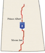
Highway 2 is a provincial highway in the Canadian province of Saskatchewan
. It is the longest Saskatchewan Highway, at 809 km (503 mi). The highway is partially divided
and undivided. However, only about 18 kilometres (11.2 mi) near Moose Jaw
, 11 kilometres (6.8 mi) near Chamberlain
, and 21 kilometres (13 mi) near Prince Albert
are divided highway. Highway 2 is a major north-south route, beginning at the Canadian-American border at the Port of West Poplar River, and Opheim, Montana
customs checkpoints. Montana Highway 24
continues south. The town of La Ronge
delimits the northern terminus with Highway 102
continuing north. It passes through the major cities of Moose Jaw
in the south and Prince Albert
in the north. Highway 2 overlaps Highway 11
between the towns of Chamberlain
and Findlater
. This 11 kilometres (6.8 mi) section of road is a wrong-way concurrency. The highway ends at La Ronge
, where it becomes Highway 102
.
The highway started as a graded road in the 1920s which followed the grid lines of the early survey system and was maintained by early homesteaders of each rural municipality. Paving projects of the 1950s created all weather roads. Technological advances have paved the way for cost effective methods of improvements to highway surfaces to meet the wear and tear of increased tourist and commercial highway traffic. The stretch of Highway 2 from Moose Jaw to Prince Albert was designated in 2005 as Veterans Memorial Highway. The designation coincided with Veterans Week 2005. The CanAm Highway
comprises Saskatchewan Highways 35
, 39
, 6
, 3
, and 2.
 Saskatchewan Highway 2 departs the Canada – United States border in a northerly direction. Montana Highway 24
continues in a southerly direction in the United States
. The United States border crossing is in Opheim, Montana
and the Canadian is at West Poplar River.
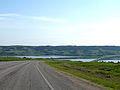
Nearby there are campgrounds available, and a point of information regarding the crossing of Poplar River. The area is rich in history, this is the Big Muddy Badlands
area which featured the hideouts of outlaws and rum runners of the nineteenth and early twentieth century. This area remained above the Quaternary
age ice sheets, being pushed and folded by the glacier
movement resulting in glaciotectonic hills. The highway winds up, down and around these hills along the way. The Big Muddy Badlands are within the Missouri Coteau. At km 12.2 the highway reaches Kildeer, and the intersection with Highway 18
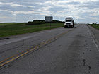
. Access to Wood Mountain Post Provincial Historical Park is obtained by following Highway 18 north for 17.4 kilometres (10.8 mi). This section of Highway 2 begins as a Class 4 highway and is under the jurisdiction of the Saskatchewan Highways and Transportation (SHT)
South West Transportation Planning Council. The highway is a secondary weight highway with a thin membrane surface type as it only has an average of 390 vehicles per day (vpd) according to the 2007 Average Annual Daily Traffic (AADT) count which was taken north of Rockglen. Highway 2 begins a concurrency with Highway 18 in a northeasterly direction. Alfalfa
and alfalfa mixtures, hay
and fodder
crop
s and spring wheat
are the main crops in Old Post
rural municipality (RM)
. There is a point of information at km 42.3. This area is known as the Wood Mountain Uplands where there are mining endeavours undertaken such as coal
, bentonite
, kaolinitic
and ceramic clays. Paleontological digs have uncovered a 63-million-year-old sea turtle which has been excavated in the Killdeer region. Rockglen
is located at km 49.7, and Highway 2 now extends in a northerly direction again. Rockglen (Population 450 in 2001 and 360 in 2006 ) and Assiniboia
( 2,483 in 2001 and 2,305 in 2006 ) are the two largest centers between the border and the city of Moose Jaw
. This geographical region of Highway 2 from Rockglen to Assiniboia has been upgraded to a Class 3 highway as it carries approximately 800 vehicles per day counted to the south of Assiniboia. Therefore the surface type before Assiniboia is a granular road surface which is a structural pavement with a hot mix surface coating. The highway type, surface, maintenance and construction projects are looked after by the SHS South Central Traffic Planning Committee. Fife Lake is located to the north east of the highway. The St. Victor Petroglyph Historic Park is located just to the west of Highway 2 by 10.4 kilometres (6.5 mi). These unique petroglyph
features carved into the sandstone are slowly disappearing..jpg) At 104.8 kilometres (65.1 mi) is the town of Assiniboia where 1,260 vpd results in the highway designated as an asphalt concrete (AS)
At 104.8 kilometres (65.1 mi) is the town of Assiniboia where 1,260 vpd results in the highway designated as an asphalt concrete (AS)
Class 2 primary weight highway all the way to Moose Jaw. Junction with Highway 13
, the Redcoat Trail
occurs at km 106.4, providing access to Lafleche
. Vantage
is located to the west of the highway along this stretch, with access provided at km 129.2. Mossbank
is located at the intersection with Highway 718
. Here is the southeast portion of Old Wives Lake
, which is a part of the Chaplin
, Old Wives Lake
, Reed Lakes (Hemispheric) - Western Hemisphere Shorebird Reserve Network
(WHSRN) Site, a designated Hemispheric Shorebird Reserve Network, protecting three saline lakes, saline and freshwater marsh
es. Ardill is located near the northern extremity of Lake of the Rivers. Highway 36
is located at km 176.4, which provides access to Crestwynd, and the Jean Louis Legare Regional Park. At km 184.5, is the junction with Highway 716
west providing access to Briercrest
.
 The home of the Snowbirds
, the Canadian Forces
431 Air Demonstration Squadron is at CFB Moose Jaw, Bushell Park
at the km 204.4 junction with Highway 363. Before entering the city of Moose Jaw is a 18 kilometres (11.2 mi) divided or twinned
highway section. The city of Moose Jaw does not have a circle drive
, and highway 2 goes through the centre of the city. Moose Jaw, a city of 32,132 features large roadside attractions such as Capone's Car, Moose Family and Mac the moose
. Temple Gardens Mineral Spa Resort
, Tunnels of Moose Jaw, and History of Transportation Western Development Museum
. are major sites of interest of this city.
 The Saskatchewan Highway 1 intersection with Highway 2 is north of Moose Jaw. At km 230.9, access to Buffalo Pound Provincial Park
is provided to the east of Highway 2 by traveling another 11.8 kilometres (7.3 mi). Access to the small town of Tuxford
is provided at km 232.8, at the Highway 42
junction. The SHS Central Area Transportation Planning Committee monitors this primary weight highway between Moose Jaw and Meacham. Between the two national highway systems of the Trans Canada Saskatchewan Highway 1 and Saskatchewan Highway 11
, Highway 2 is also designated as a Class 1 AC national connector highway. There is a point of information on the south side of the Qu'Appelle Valley
, km 246.3. A second point of information is on the northern bank of the Qu'Appelle Valley at km 250.0. Buffalo Pound Lake
, a eutrophic prairie lake
was formed by glaciation 10,000 years ago. At the junction of highway 11
, is the town of Chamberlain
where the highway which travels north begins a southeast 11.4 kilometres (7.1 mi) wrong-way concurrency at Chamberlain. Whre these two national highways overlap, a divided highway
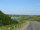
segment handles the AADT which is about 4500 vpd. There is a rest area at km 281.1 south of Chamberlain with an historical marker. To the west of the highway are afforded views of the Arm River valley. At km 276.1, the highway takes a sharp turn to continue north as it leaves the Highway 11 concurrency. After the concurrency, Highway 2 is a class 3 AC primary weight highway until Watrous. The junction of Highway 733 in 11.5 kilometres (7.1 mi) provides access to Last Mountain Lake
(Long Lake) traveling east. Holdfast is accessed at the Highway 732 junction. Penzance is east of the highway at km 305.0, where Highway 732 turns north, forming the beginning of a 18.2 kilometres (11.3 mi) concurrency. Liberty is a small community at km 320.5. Located near Stalwart is the Stalwart National Wildlife Area, a wetlands region. Watertown (1903–1910) provides easy access to Etter's Beach on Long Lake. The settlers of Watertown established a post office named Harkness Post Office, Assiniboia, North West Territories
. With the arrival of the rail, the village became known as Imperial. The town of Imperial is the largest center west of Last Mountain Lake
with a population around 300 and an AADT of close to 650 vpd. The village of Simpson
is also along the highway which runs parallel to Last Mountain Lake
. There are several roadside turnouts to access Last Mountain Lake from Highway 2. The Last Mountain Lake Sanctuary was the first federal bird sanctuary. Highway 15
provides access to Nokomis
to the east, and Kenaston
to the west. The small hamlet of Amazon is located before Watrous. Watrous is a tourist destination due to its proximity to Manitou Beach and the ehdorheic Little Manitou Lake. Watrous, in the Land of Living Waters, is a tourist destination due to its proximity to Manitou Beach, home of the world famous Mineral Spa and Danceland dance hall (known as the "Home of the World Famous Dance Floor Built on Horsehair"). The AADT near this tourist town of 1,800 people raises to about 1,250 vpd which ranks it as a class 2 highway. Highway 2 continues in a northwest direction to circumnavigate around Little Manitou until it gets to the Young and the junction of Highway 670. Young and Zelma were two communities that were part of the alphabet railway of the Canadian National Railway
(CNR). The Yellowhead Highway
is at km 426.3. Colonsay is located to the west, and Plunkett to the east. Colonsay is the location of one of several potash mines in Saskatchewan, a major employer of the region. Potash evaporites were laid down during the geological formation of the Western Canadian Sedimentary Basin
. The SHS North Central Transportation Planning Committee tends to highway maintenance and construction decisions north of the Yellowhead highway. Highway 2 from the Yellowhead through to Prince Albert is a class 2 primary weight AC highway. Over 1,000 vehicles travel Highway 2 between Watrous and Meacham, and of these less than 100 of them are trucks. The majority of commercial trucks near the Highway 2 and 5
intersection travel Highway 5. The AADT after the intersection is under 350 vpd.
Highway 5 provides access to the city of Saskatoon
, the largest city in the province. There is a 5.6 kilometres (3.5 mi) concurrency between Highway 5 and 2 upon which there are close to 2,000 vpd. Highway 5
east provides access to the city of Humboldt
. Meacham at km 442.0 is located in the Aspen Parkland ecoregion
. Throughout the Aspen Parkland ecoregion are trembling aspen (Populus tremuloides )
bluffs (small islands or shelter belts) within the prairie region. Deer
and other large ungulate
s are a hazard to traffic resulting in potential animal or human deaths, especially in the autumn mating months or when deer are searching for feeding grounds in the spring. The defense mechanism of deer in the face of a threat is to freeze. There are over 3,500 deer - auto collisions per year in Saskatchewan. A number of measures have been implemented to increase awareness such as fencing, feeding programs, automobile whistles. Deer mirrors along the edges of highways were installed for reducing deer-vehicle collisions. The Wildlife Warning System is triggered by highway vehicles, setting off lights, sounds and or odours ahead of the approaching vehicle to frighten away animals. Some systems that detect vehicles, where others detect large animals and sets off a warning system to drivers of vehicles alerting them that an animal is on or near the highway ahead of time. The junction with Highway 27
occurs at km 468.0 providing access west to the village of Prud'homme
and off to the east is Muskiki Lake. Cudworth
is located at the Highway 777 intersection, bearing east on highway 777 provides access to Middle Lake
. The intersection of Highway 41
is located at Wakaw
, which features a golf course
, campground and recreation site at Wakaw Lake. The community considered a proposal to construct a canal
between the lake and the town to be developed into a marina
- resort
- tourism
area. Traffic around this tourist town of 864 increases between 650 to 1050 vpd.
 At the junction of Highway 25
is the town of St. Louis
where there is a historical paranormal phenomenon called the St. Louis Light or the St. Louis Ghost Train
. Domremy
, located at the junction of Highway 320
and Highway 225
, constructed a park to commemorate the province's centennial celebrations. Highway 225
provides access to the Batoche National Historical Site, which was the site of the last stand of Metis
rights activist Louis Riel
prior to his subsequent trial and death in 1885. The village of Hoey is located at km 529.6. St. Louis was recently the site of the discovery of a large archaeological site of aboriginal artifacts.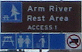 The South Saskatchewan River
is crossed at this point via the St. Louis Bridge
. Traffic around St. Louis averaged about 1,500 and escalates to 6,000 after the junction with the Highway 11
, the Louis Riel Trail occurs just south of Prince Albert at km 562.9.
joins with Highway 2 at km 568.4, becoming a concurrency for 1.6 kilometre (0.994196378639691 mi) After crossing the North Saskatchewan River
the concurrency of Highway 2 and 3 end at the interchange with Highway 55. There is a 11 kilometres (6.8 mi) divided or twinned
highway segment north of Prince Albert. Highway 2 continues northward as a AC primary weight CanAm international highway
from this point northward taking over from the highway 3 segment. Prince Albert, a city of over 34,000, is a part of the boreal transition ecoregion, agricultural fields and forested areas border the highway rural areas. At km 593.9, Highway 2 meets with the intersection of Highway 325. To the northwest of this intersection is Little Red River Indian Reserve 106C and Montreal Lake 106B Indian Reserves. Christopher Lake
is at the km 610.0 junction of Highway 791
east and Highway 263 west
. Highway 263 provides access to the Prince Albert National Park
. This ecoregion is a part of the mid-boreal upland. At km 646.9, Highway 2 meets with Highway 264
which provides access to Waskesiu Lake in the Prince Albert National Park
. At km 660.5 there is an intersection with Highway 969
, another access to the Park westerly, and eastern access to Montreal Lake 106 Indian Reserve. There are fewer roads in the southern boreal forest. Highway 2 makes the next highway connection at km 693.1 with Highway 916.
There are over 10,000 lakes across Saskatchewan
, with the main lake region being north of the tree line in the Canadian Shield
. Montreal Lake is located west of Highway 2, its northern shores near Weyakwin at km 716.2, then at km 758.5 Highway 2 meets with Highway 165
which travels north to Morin Lake
217 Indian Reserve. Lac la Ronge
156 Indian Reserve is at km 805.9 before the ending terminus in the northern boreal forest at La Ronge
and the junction with Highway 102
.
, 16 horses and a dump wagon.
The Saskatchewan Highway Act was established in 1922, in compliance with the 1919 Canadian highway act. At the initial stages of the Saskatchewan Highway Act, 10 miles (16.1 km) of highway were gravel and the rest were earth roads. The road allowances were laid out as a part of the Dominion Land survey system for homesteading. In 1929, the R.M. of Wood Creek #281 conducted roadwork with three graders, 53 slush scrapers, 15 wheel scrapers and five ploughs. Development of highways began in the 1920s and was virtually halted in the depression years of the 1930s. Early homesteaders, such as John Abrey, would do road maintenance work themselves in this era. In the 1930s seeing a car was rare, Alexander Black remembers taking 150 bushels on a grain tank with a four horse hitch
. When they reached highway 2, the horse
s bolted through town until they snagged on the railway switch by the elevators. Travel along the Provincial Highway 5 before the 1940s would have been traveling on the square following the township road allowances, barbed wire
fencing and rail lines. As the surveyed township roads were the easiest to travel, the first highway
was designed on 90-degree, right-angle corners as the distance traversed the prairie along range roads and township roads.
The two industrial revolutions first
and second
combined with advancements made during the war
years resulted in the largest impetus in highway construction of all weather roads following World War II
. The creation of the highway south of Chamberlain to Moose Jaw was completed in 1953. Paving projects followed within a short time period. In 1955 parts of Highway 2 were already paved; Between Vantage and Tuxford, either side of Moose Jaw; north of Watrous along the Little Manitou Lake shoreline; and north of the junction with Highway 27 to Montreal Lake, either side of Prince Albert. In 1956 a North-South International Highway proposal regarding a highway between El Paso, Texas, and LaRonge via Wakaw was discussed. The CanAm Highway northern segment into La Ronge finished construction in 1977; however, the CanAm didn't go through Wakaw, rather it comprised several different routes making the CanAm. Highway 2, which does go through Wakaw, does link to the CanAm highway at Prince Albert when Highway 2 becomes the last portion of the CanAm highway. In 1952, Highway 2 was re-routed; rather than winding its way through the town of Wakaw, the highway's new route went straight along the western limit of town.
Agriculture
is Saskatchewan's main industry and taking grain
to elevator
s was first accomplished by horse and cart
, to be replaced around World War I by truck
travel. Long haul trucking flourished between 1950 and 1970. Since the 1970s, 17 times the number of grain trucks and 95 percent of goods transported now are hauled by truck across the Saskatchewan.
In 1999, the granular pavement section of Highway 2 south of Watrous was tested with a cold in-place recycling or “CIR” method to rehabilitate highways. This CIR process is a cost effective method which recycles the top surface of a road. This pulvarized material is mixed with asphalt emulsion and spread and compacted back onto the highway surface. This surface is then recovered with a new seal dependant on traffic volume.
In 2001, 6.6 kilometres (4.1 mi) were resurfaced near the Cudworth access road, as well 3.7 kilometres (2.3 mi) km north of the Highway 27 junction. "Highway 2 near Cudworth has seen an increase in truck traffic that is leading to deterioration
on this highway...It's important to keep our highways in good driving condition to ensure the safety of the travelling public." -Highways and Transportation Minister Maynard Sonntag. As recently as 2002, this section of Highway 2 was improved 10.4 kilometres (6.5 mi) south of the Yellowhead. At km 398.1 is access to Zelma.
'Highway 2 has seen an increase in truck traffic, leading to wear and tear on this highway...We are paving a section of this highway as it has deteriorated over the past number of years. Saskatchewan Highways and Transportation is working hard to fix roads across the province to improve driver safety. - " Highways and Transportation Minister Mark Wartman
 As a tribute to Saskatchewan veterans, Premier Lorne Calvert
, Highways and Transportation Minister Eldon Lautermilch and Past Provincial President of the Royal Canadian Legion, Saskatchewan Command, John Henderson together unveiled the new highway sign on November 10, 2005]. The ceremony was held during veteran's week, November 5–11th, and also commemorates The Year of the Veteran, 2005. The highway designation coincides with Veterans Week (November 5–11) and was one of several significant honours bestowed to veterans in 2005, The Year of the Veteran. The Year of the Veteran commemorates the 60th Anniversary of the end of the World War II
. The Royal Canadian Legion, Saskatchewan Command and Saskatchewan Remembers Committee came together to select this particular highway of Saskatchewan because of the history of a military presence along the route. Royal Canadian Legion branches are located at Moose Jaw
, Penance
- Holdfast
, Young - Zelma
, Watrous
, Simpson
, and Prince Albert
. A military history museum is located at the Watrous
, as well military memorabilia is held at Prince Albert
Royal Canadian Legion branch. Moose Jaw
Royal Canadian Air Force
RCAF and 15 Wing military base
is located 5.5 kilometres (3.4 mi) south-southwest of Moose Jaw
.
. The Highway 2 segment designated as the CanAm Highway is located between Prince Albert
and La Ronge
. The entire length of the CanAm Highway
route is 4122 kilometres (2,561.3 mi) and extends from El Paso, TX
at Mexican Border (MX 45
) to La Ronge
at the Saskatchewan Highway 2 - SK 102
intersection. The North American Free Trade Agreement (NAFTA)
super corridors connect Mexico, United States, and Canada. The CanAm highway was a concept that began in the 1920s. A stretch of highway between Amazon and Watrous is slated for maintenance between 208 and 2009, as well as the Highway 5 - Highway 2 concurrency which carries about 2,000 vpd on average through the year. Also the 14 kilometres (8.7 mi) segment between Highways 264 and 969 is a 2008-09 maintenance project.
Saskatchewan
Saskatchewan is a prairie province in Canada, which has an area of . Saskatchewan is bordered on the west by Alberta, on the north by the Northwest Territories, on the east by Manitoba, and on the south by the U.S. states of Montana and North Dakota....
. It is the longest Saskatchewan Highway, at 809 km (503 mi). The highway is partially divided
Dual carriageway
A dual carriageway is a class of highway with two carriageways for traffic travelling in opposite directions separated by a central reservation...
and undivided. However, only about 18 kilometres (11.2 mi) near Moose Jaw
Moose Jaw, Saskatchewan
Moose Jaw is a city in south-central Saskatchewan, Canada on the Moose Jaw River. It is situated on the Trans-Canada Highway, west of Regina. Residents of Moose Jaw are known as Moose Javians. It is best known as a retirement and tourist city that serves as a hub to the hundreds of small towns...
, 11 kilometres (6.8 mi) near Chamberlain
Chamberlain, Saskatchewan
Chamberlain is a village in south-central Saskatchewan, Canada. Health Department statistics for 2003 put its population at 116 and the new census of 2006 cites 108 for the new population....
, and 21 kilometres (13 mi) near Prince Albert
Prince Albert, Saskatchewan
Prince Albert is the third-largest city in Saskatchewan, Canada. It is situated in the centre of the province on the banks of the North Saskatchewan River. The city is known as the "Gateway to the North" because it is the last major centre along the route to the resources of northern Saskatchewan...
are divided highway. Highway 2 is a major north-south route, beginning at the Canadian-American border at the Port of West Poplar River, and Opheim, Montana
Opheim, Montana
Opheim is a town in Valley County, Montana, United States. The population was 111 at the 2000 census.-Geography:Opheim is located at .According to the United States Census Bureau, the town has a total area of , all of it land....
customs checkpoints. Montana Highway 24
Montana Highway 24
Montana Highway 24 is a long state highway in the US state of Montana. It begins at Montana Highway 200 near Brockway, and ends at the Saskatchewan border at Port of Opheim. Along the way, it intersects MT 117, MT 42 and U.S. 2...
continues south. The town of La Ronge
La Ronge, Saskatchewan
La Ronge is a community of about 2,700 people in Northern Saskatchewan, Canada, 250 km north of Prince Albert. There are an additional 2,000 people living in the Lac La Ronge First Nation bordering the town, and another 1,000 people living in the neighbouring community of Air Ronge...
delimits the northern terminus with Highway 102
Saskatchewan Highway 102
Highway 102 is a highway in the Canadian province of Saskatchewan. It runs from Highway 2 at La Ronge and Lac La Ronge Provincial Park to Southend, at Reindeer Lake. Highway 102 is about 216 km long, the majority of which is gravel surface....
continuing north. It passes through the major cities of Moose Jaw
Moose Jaw, Saskatchewan
Moose Jaw is a city in south-central Saskatchewan, Canada on the Moose Jaw River. It is situated on the Trans-Canada Highway, west of Regina. Residents of Moose Jaw are known as Moose Javians. It is best known as a retirement and tourist city that serves as a hub to the hundreds of small towns...
in the south and Prince Albert
Prince Albert, Saskatchewan
Prince Albert is the third-largest city in Saskatchewan, Canada. It is situated in the centre of the province on the banks of the North Saskatchewan River. The city is known as the "Gateway to the North" because it is the last major centre along the route to the resources of northern Saskatchewan...
in the north. Highway 2 overlaps Highway 11
Saskatchewan Highway 11
Highway 11 is a major north-south highway in Saskatchewan, Canada that connects the province's three largest cities: Regina, Saskatoon and Prince Albert. It is a structural pavement major arterial highway which is approximately long. It is also known as the Louis Riel Trail after the 19th century...
between the towns of Chamberlain
Chamberlain, Saskatchewan
Chamberlain is a village in south-central Saskatchewan, Canada. Health Department statistics for 2003 put its population at 116 and the new census of 2006 cites 108 for the new population....
and Findlater
Findlater, Saskatchewan
-Notable people:*Joy Coghill , O.C., is a Canadian actor, director, and writer.- See also :* List of communities in Saskatchewan* Villages of Saskatchewan-External links:*******-Footnotes:...
. This 11 kilometres (6.8 mi) section of road is a wrong-way concurrency. The highway ends at La Ronge
La Ronge, Saskatchewan
La Ronge is a community of about 2,700 people in Northern Saskatchewan, Canada, 250 km north of Prince Albert. There are an additional 2,000 people living in the Lac La Ronge First Nation bordering the town, and another 1,000 people living in the neighbouring community of Air Ronge...
, where it becomes Highway 102
Saskatchewan Highway 102
Highway 102 is a highway in the Canadian province of Saskatchewan. It runs from Highway 2 at La Ronge and Lac La Ronge Provincial Park to Southend, at Reindeer Lake. Highway 102 is about 216 km long, the majority of which is gravel surface....
.
The highway started as a graded road in the 1920s which followed the grid lines of the early survey system and was maintained by early homesteaders of each rural municipality. Paving projects of the 1950s created all weather roads. Technological advances have paved the way for cost effective methods of improvements to highway surfaces to meet the wear and tear of increased tourist and commercial highway traffic. The stretch of Highway 2 from Moose Jaw to Prince Albert was designated in 2005 as Veterans Memorial Highway. The designation coincided with Veterans Week 2005. The CanAm Highway
CanAm Highway
CanAm Highway passes through these states in the United States; Texas, New Mexico, Colorado, Wyoming, South Dakota, North Dakota, as well as the province of Saskatchewan, Canada. The international Can-Am Highway travels along U.S. Route 85 and Interstate 25, connecting Mexico to Canada through...
comprises Saskatchewan Highways 35
Saskatchewan Highway 35
Highway 35 is a paved undivided provincial highway in the Canadian province of Saskatchewan. It runs from the US Border near Port of Oungre to a dead end near the north shore of Tobin Lake. Saskatchewan Highway 35 SK Hwy 35) is about long. The CanAm Highway comprises Saskatchewan Highways 35,...
, 39
Saskatchewan Highway 39
Highway 39 is a provincial paved undivided highway located in the southern portion of the Canadian province of Saskatchewan connecting North Portal and Moose Jaw in the north. This is a primary Saskatchewan highway maintained by the provincial and national governments providing a major trucking...
, 6
Saskatchewan Highway 6
Highway 6 is a paved undivided major provincial highway in the Canadian province of Saskatchewan. It runs from Montana Highway 16 at the Saskatchewan border with the US near the Canada customs port of Regway to Highway 55 near Choiceland. Highway 6 is about long. The CanAm Highway comprises ...
, 3
Saskatchewan Highway 3
Highway 3 is a major provincial paved undivided highway in the Canadian province of Saskatchewan. It runs from the Alberta border, continues west as Alberta Highway 45 to the Manitoba border, and then continues east as Highway 77. Highway 3 is about 615 km long. The CanAm Highway comprises ...
, and 2.
Travel route
Montana Highway 24
Montana Highway 24 is a long state highway in the US state of Montana. It begins at Montana Highway 200 near Brockway, and ends at the Saskatchewan border at Port of Opheim. Along the way, it intersects MT 117, MT 42 and U.S. 2...
continues in a southerly direction in the United States
United States
The United States of America is a federal constitutional republic comprising fifty states and a federal district...
. The United States border crossing is in Opheim, Montana
Opheim, Montana
Opheim is a town in Valley County, Montana, United States. The population was 111 at the 2000 census.-Geography:Opheim is located at .According to the United States Census Bureau, the town has a total area of , all of it land....
and the Canadian is at West Poplar River.
Nearby there are campgrounds available, and a point of information regarding the crossing of Poplar River. The area is rich in history, this is the Big Muddy Badlands
Big Muddy Badlands
The Big Muddy Badlands are a series of badlands in southern Saskatchewan and northern Montana along Big Muddy Creek. They are found in the Big Muddy Valley, a cleft of erosion and sandstone along Big Muddy Creek. The valley is long, wide and deep...
area which featured the hideouts of outlaws and rum runners of the nineteenth and early twentieth century. This area remained above the Quaternary
Quaternary
The Quaternary Period is the most recent of the three periods of the Cenozoic Era in the geologic time scale of the ICS. It follows the Neogene Period, spanning 2.588 ± 0.005 million years ago to the present...
age ice sheets, being pushed and folded by the glacier
Glacier
A glacier is a large persistent body of ice that forms where the accumulation of snow exceeds its ablation over many years, often centuries. At least 0.1 km² in area and 50 m thick, but often much larger, a glacier slowly deforms and flows due to stresses induced by its weight...
movement resulting in glaciotectonic hills. The highway winds up, down and around these hills along the way. The Big Muddy Badlands are within the Missouri Coteau. At km 12.2 the highway reaches Kildeer, and the intersection with Highway 18
Saskatchewan Highway 18
Highway 18 is a highway in the Canadian province of Saskatchewan. It runs from Highway 13 near Robsart to the Manitoba border near Gainsborough, where it becomes Highway 3. Highway 18 is about 714 km long.-Communities along the route:...
. Access to Wood Mountain Post Provincial Historical Park is obtained by following Highway 18 north for 17.4 kilometres (10.8 mi). This section of Highway 2 begins as a Class 4 highway and is under the jurisdiction of the Saskatchewan Highways and Transportation (SHT)
Ministry of Highways and Infrastructure (Saskatchewan)
The Ministry of Highways and Infrastructure or Highways and Infrastructure — Government of Saskatchewan Ministry of Highways is divided into the Operations, Policy and Programs, and Corporate Services Divisions and the Communications Branch. The ministry is the employer of over 1,476...
South West Transportation Planning Council. The highway is a secondary weight highway with a thin membrane surface type as it only has an average of 390 vehicles per day (vpd) according to the 2007 Average Annual Daily Traffic (AADT) count which was taken north of Rockglen. Highway 2 begins a concurrency with Highway 18 in a northeasterly direction. Alfalfa
Alfalfa
Alfalfa is a flowering plant in the pea family Fabaceae cultivated as an important forage crop in the US, Canada, Argentina, France, Australia, the Middle East, South Africa, and many other countries. It is known as lucerne in the UK, France, Australia, South Africa and New Zealand, and known as...
and alfalfa mixtures, hay
Hay
Hay is grass, legumes or other herbaceous plants that have been cut, dried, and stored for use as animal fodder, particularly for grazing livestock such as cattle, horses, goats, and sheep. Hay is also fed to pets such as rabbits and guinea pigs...
and fodder
Fodder
Fodder or animal feed is any agricultural foodstuff used specifically to feed domesticated livestock such as cattle, goats, sheep, horses, chickens and pigs. Most animal feed is from plants but some is of animal origin...
crop
Crop
Crop may refer to:* Crop, a plant grown and harvested for agricultural use* Crop , part of the alimentary tract of some animals* Crop , a modified whip used in horseback riding or disciplining humans...
s and spring wheat
Wheat
Wheat is a cereal grain, originally from the Levant region of the Near East, but now cultivated worldwide. In 2007 world production of wheat was 607 million tons, making it the third most-produced cereal after maize and rice...
are the main crops in Old Post
Old Post No. 43, Saskatchewan
Old Post No. 43 is a rural municipality in southern Saskatchewan, Canada encompassing 1,757.00 square kilometers in area. The rural municipality in conjunction with the provincial government is in charge of maintenance of highways in its area...
rural municipality (RM)
Rural municipality
A rural municipality, often abbreviated RM, is a form of municipality in the Canadian provinces of Manitoba and Saskatchewan, perhaps best comparable to counties or townships in the western United States...
. There is a point of information at km 42.3. This area is known as the Wood Mountain Uplands where there are mining endeavours undertaken such as coal
Coal
Coal is a combustible black or brownish-black sedimentary rock usually occurring in rock strata in layers or veins called coal beds or coal seams. The harder forms, such as anthracite coal, can be regarded as metamorphic rock because of later exposure to elevated temperature and pressure...
, bentonite
Bentonite
Bentonite is an absorbent aluminium phyllosilicate, essentially impure clay consisting mostly of montmorillonite. There are different types of bentonite, each named after the respective dominant element, such as potassium , sodium , calcium , and aluminum . Experts debate a number of nomenclatorial...
, kaolinitic
Kaolinite
Kaolinite is a clay mineral, part of the group of industrial minerals, with the chemical composition Al2Si2O54. It is a layered silicate mineral, with one tetrahedral sheet linked through oxygen atoms to one octahedral sheet of alumina octahedra...
and ceramic clays. Paleontological digs have uncovered a 63-million-year-old sea turtle which has been excavated in the Killdeer region. Rockglen
Rockglen, Saskatchewan
Rockglen, Saskatchewan, Canada, is a community in the Burning Hills of the Wood Mountain Uplands, providing a school, community hall, public library and five parks, as well a local service industry. The municipal office of Rural Municipality #12 Old Post lies within the boundaries of Rockglen, and...
is located at km 49.7, and Highway 2 now extends in a northerly direction again. Rockglen (Population 450 in 2001 and 360 in 2006 ) and Assiniboia
Assiniboia, Saskatchewan
Assiniboia is a town in south central Saskatchewan, Canada. It is located south-southwest of Moose Jaw beside Highway 2 and Highway 13.-History:...
( 2,483 in 2001 and 2,305 in 2006 ) are the two largest centers between the border and the city of Moose Jaw
Moose Jaw, Saskatchewan
Moose Jaw is a city in south-central Saskatchewan, Canada on the Moose Jaw River. It is situated on the Trans-Canada Highway, west of Regina. Residents of Moose Jaw are known as Moose Javians. It is best known as a retirement and tourist city that serves as a hub to the hundreds of small towns...
. This geographical region of Highway 2 from Rockglen to Assiniboia has been upgraded to a Class 3 highway as it carries approximately 800 vehicles per day counted to the south of Assiniboia. Therefore the surface type before Assiniboia is a granular road surface which is a structural pavement with a hot mix surface coating. The highway type, surface, maintenance and construction projects are looked after by the SHS South Central Traffic Planning Committee. Fife Lake is located to the north east of the highway. The St. Victor Petroglyph Historic Park is located just to the west of Highway 2 by 10.4 kilometres (6.5 mi). These unique petroglyph
Petroglyph
Petroglyphs are pictogram and logogram images created by removing part of a rock surface by incising, picking, carving, and abrading. Outside North America, scholars often use terms such as "carving", "engraving", or other descriptions of the technique to refer to such images...
features carved into the sandstone are slowly disappearing.
Asphalt concrete
Asphalt concrete is a composite material commonly used in construction projects such as road surfaces, airports and parking lots. It consists of asphalt and mineral aggregate mixed together, then laid down in layers and compacted...
Class 2 primary weight highway all the way to Moose Jaw. Junction with Highway 13
Saskatchewan Highway 13
Highway 13 is a highway in the Canadian province of Saskatchewan. It runs from the Alberta border until it transitions into Highway 2 at the Manitoba border near Antler. Highway 13 is about 676 km long.Highway 13 passes through Shaunavon, Assiniboia, Weyburn, Redvers and Carlyle...
, the Redcoat Trail
Saskatchewan Highway 13
Highway 13 is a highway in the Canadian province of Saskatchewan. It runs from the Alberta border until it transitions into Highway 2 at the Manitoba border near Antler. Highway 13 is about 676 km long.Highway 13 passes through Shaunavon, Assiniboia, Weyburn, Redvers and Carlyle...
occurs at km 106.4, providing access to Lafleche
Lafleche, Saskatchewan
Lafleche is a small community in southwest Saskatchewan, Canada. As of 2006, the population of Lafleche is 370.-Community profile:In 1913 the Canadian Pacific Railway came to Lafleche. In 1937 after eight consecutive crop failures, the once prosperous Lafleche district was near rock bottom...
. Vantage
Vantage, Saskatchewan
Vantage is a hamlet in the Canadian province of Saskatchewan. Listed as a designated place by Statistics Canada, the hamlet had a reported population of zero in the Canada 2006 Census.Vantage Methodist Church 1917Vantage, Saskatchewan...
is located to the west of the highway along this stretch, with access provided at km 129.2. Mossbank
Mossbank, Saskatchewan
Mossbank is a town in the province of Saskatchewan, Canada. It is located south of Old Wives Lake and 70 km south of Moose Jaw- See also :* List of communities in Saskatchewan* List of towns in Saskatchewan* RCAF Station Mossbank- History :...
is located at the intersection with Highway 718
Saskatchewan Highway 718
Highway 718 is a highway in the Canadian province of Saskatchewan. It runs from Highway 2 near Mossbank to Highway 610 near Bateman. Highway 718 is about 67 km long.Highway 718 also connects with Highways 58 and 627....
. Here is the southeast portion of Old Wives Lake
Old Wives Lake
Old Wives Lake is a shallow saline lake in south central Saskatchewan, Canada, about 30 km southwest of Moose Jaw. The lake is fed by the Wood River but seasonal water relatively flattened the terrain, and as such results in significant mudflats. A Migratory Bird Sanctuary was established at the...
, which is a part of the Chaplin
Chaplin, Saskatchewan
Chaplin is a rural village in Saskatchewan, Canada situated on the Trans-Canada Highway approximately 85 km from Moose Jaw and 90 km from Swift Current. The main industries of Chaplin are Saskatchewan Minerals and farming/ ranching. Chaplin consists of eight streets, two crescents, and...
, Old Wives Lake
Old Wives Lake
Old Wives Lake is a shallow saline lake in south central Saskatchewan, Canada, about 30 km southwest of Moose Jaw. The lake is fed by the Wood River but seasonal water relatively flattened the terrain, and as such results in significant mudflats. A Migratory Bird Sanctuary was established at the...
, Reed Lakes (Hemispheric) - Western Hemisphere Shorebird Reserve Network
Western Hemisphere Shorebird Reserve Network
The Western Hemisphere Shorebird Reserve Network is a conservation strategy targeting shorebirds in the Americas launched in 1985. Its aim is to protect the nesting, breeding and staging habitats of migratory shorebirds...
(WHSRN) Site, a designated Hemispheric Shorebird Reserve Network, protecting three saline lakes, saline and freshwater marsh
Marsh
In geography, a marsh, or morass, is a type of wetland that is subject to frequent or continuous flood. Typically the water is shallow and features grasses, rushes, reeds, typhas, sedges, other herbaceous plants, and moss....
es. Ardill is located near the northern extremity of Lake of the Rivers. Highway 36
Saskatchewan Highway 36
Highway 36 is a highway in the Canadian province of Saskatchewan. It runs from Montana Highway 13 at the US border near Port of Coronach to Highway 2. Highway 36 is about 144 km long.-Intersections from south to north:...
is located at km 176.4, which provides access to Crestwynd, and the Jean Louis Legare Regional Park. At km 184.5, is the junction with Highway 716
Saskatchewan Highway 716
Highway 716 is a highway in the Canadian province of Saskatchewan. It runs from Highway 2 to Highway 339 near Briercrest. Highway 716 is about 21 km long....
west providing access to Briercrest
Briercrest, Saskatchewan
-Area statistics:*Lat 50° 10' 00" N*Long 105° 16' 00" W*Dominion Land Survey Section 18 Tsp 14 Rge 24 W2*Time zone UTC-6-External links:******...
.
Veteran's Memorial Highway
Snowbirds
Officially known as the Royal Canadian Air Force's 431 Air Demonstration Squadron, the Snowbirds are Canada's military aerobatics or air show flight demonstration team whose purpose is to "demonstrate the skill, professionalism, and teamwork of Canadian Forces personnel". The squadron is based at...
, the Canadian Forces
Canadian Forces
The Canadian Forces , officially the Canadian Armed Forces , are the unified armed forces of Canada, as constituted by the National Defence Act, which states: "The Canadian Forces are the armed forces of Her Majesty raised by Canada and consist of one Service called the Canadian Armed Forces."...
431 Air Demonstration Squadron is at CFB Moose Jaw, Bushell Park
Bushell Park, Saskatchewan
Bushell Park is a hamlet in Saskatchewan. It is located 5 km south of Moose Jaw and is home to CFB Moose Jaw a.k.a 15 Wing, Moose Jaw, where the Snowbirds flight demonstration team is based. The Moose Jaw airshow is performed from the base. There is a scout camp 2km to the east, which is often used...
at the km 204.4 junction with Highway 363. Before entering the city of Moose Jaw is a 18 kilometres (11.2 mi) divided or twinned
Dual carriageway
A dual carriageway is a class of highway with two carriageways for traffic travelling in opposite directions separated by a central reservation...
highway section. The city of Moose Jaw does not have a circle drive
Circle Drive
Circle Drive is a major road constructed as a ring road in Saskatoon, Saskatchewan, Canada. The northeastern portion of the road is part of the Yellowhead Highway.-History:...
, and highway 2 goes through the centre of the city. Moose Jaw, a city of 32,132 features large roadside attractions such as Capone's Car, Moose Family and Mac the moose
Mac the moose
Mac the Moose is a fibreglass moose in Moose Jaw, Saskatchewan. It is claimed to be the world's largest moose at feet tall and a weight of approximately . The giant moose is important to the city of Moose Jaw because it was one of its first tourist attractions. Moose Jaw now has many tourist...
. Temple Gardens Mineral Spa Resort
Temple Gardens Mineral Spa Resort
The Temple Gardens Mineral Spa Resort is a 4 star , hotel located in downtown Moose Jaw, Saskatchewan, Canada. The resort features a roof top indoor/outdoor mineral pools, and is connected to Casino Moose Jaw. In 1910, drillers looking for oil hit the hot springs that service the hotel, remains...
, Tunnels of Moose Jaw, and History of Transportation Western Development Museum
Saskatchewan Western Development Museum
The Saskatchewan Western Development Museum is a network of four museums in Saskatchewan, Canada preserving and recording the social and economic development of the province. The museum has branches in Moose Jaw, North Battleford, Saskatoon and Yorkton. Respectively, each branch focuses on a...
. are major sites of interest of this city.
Buffalo Pound Provincial Park
Buffalo Pound Provincial Park is a Saskatchewan Provincial Park located in southern Saskatchewan about 25 km northeast of the city of Moose Jaw.The park centres around Buffalo Pound Lake, a prairie lake formed from glaciation about 10,000 years ago...
is provided to the east of Highway 2 by traveling another 11.8 kilometres (7.3 mi). Access to the small town of Tuxford
Tuxford, Saskatchewan
Tuxford is a community in Saskatchewan. Moose Jaw is 14 km south and Buffalo Pound Lake is 16 km north. Highway 2, Highway 42 and Highway 202 all intersect in the community. Highway 202 connects the community to Buffalo Pound Provincial Park 11 km east...
is provided at km 232.8, at the Highway 42
Saskatchewan Highway 42
Highway 42 is a highway in the Canadian province of Saskatchewan. It runs from the intersecion of Highway 2 and Highway 202 near Tuxford until Highway 15...
junction. The SHS Central Area Transportation Planning Committee monitors this primary weight highway between Moose Jaw and Meacham. Between the two national highway systems of the Trans Canada Saskatchewan Highway 1 and Saskatchewan Highway 11
Saskatchewan Highway 11
Highway 11 is a major north-south highway in Saskatchewan, Canada that connects the province's three largest cities: Regina, Saskatoon and Prince Albert. It is a structural pavement major arterial highway which is approximately long. It is also known as the Louis Riel Trail after the 19th century...
, Highway 2 is also designated as a Class 1 AC national connector highway. There is a point of information on the south side of the Qu'Appelle Valley
Qu'Appelle River
The Qu'Appelle River is a Canadian river that flows 430 km east from Lake Diefenbaker in southwestern Saskatchewan to join the Assiniboine River in Manitoba, just south of Lake of the Prairies, near the village of St. Lazare....
, km 246.3. A second point of information is on the northern bank of the Qu'Appelle Valley at km 250.0. Buffalo Pound Lake
Buffalo Pound Lake
Buffalo Pound Lake is a eutrophic prairie lake in Saskatchewan, Canada, formed from glaciation about 10,000 years ago, on the Qu'Appelle River approximately 28 km north of Moose Jaw, 11 km east of Tuxford and 3 km north of Sun Valley...
, a eutrophic prairie lake
Prairie lake
A prairie lake is a somewhat shallow lake that will empty naturally during dry periods allowing a variety of land plants to flourish in the rich nutrients on the lake bottom. The lakes eventually fill up with water returning to their previous state. In northern Florida, a Flatwoods/Prairie Lake is...
was formed by glaciation 10,000 years ago. At the junction of highway 11
Saskatchewan Highway 11
Highway 11 is a major north-south highway in Saskatchewan, Canada that connects the province's three largest cities: Regina, Saskatoon and Prince Albert. It is a structural pavement major arterial highway which is approximately long. It is also known as the Louis Riel Trail after the 19th century...
, is the town of Chamberlain
Chamberlain, Saskatchewan
Chamberlain is a village in south-central Saskatchewan, Canada. Health Department statistics for 2003 put its population at 116 and the new census of 2006 cites 108 for the new population....
where the highway which travels north begins a southeast 11.4 kilometres (7.1 mi) wrong-way concurrency at Chamberlain. Whre these two national highways overlap, a divided highway
Dual carriageway
A dual carriageway is a class of highway with two carriageways for traffic travelling in opposite directions separated by a central reservation...
segment handles the AADT which is about 4500 vpd. There is a rest area at km 281.1 south of Chamberlain with an historical marker. To the west of the highway are afforded views of the Arm River valley. At km 276.1, the highway takes a sharp turn to continue north as it leaves the Highway 11 concurrency. After the concurrency, Highway 2 is a class 3 AC primary weight highway until Watrous. The junction of Highway 733 in 11.5 kilometres (7.1 mi) provides access to Last Mountain Lake
Last Mountain Lake
Last Mountain Lake, also known as Long Lake, is a prairie lake formed from glaciation 11,000 years ago. It is located in south central Saskatchewan, Canada, about 40 km northwest of the city of Regina adjacent to the Qu'Appelle Valley, which it flows south into through Last Mountain Creek...
(Long Lake) traveling east. Holdfast is accessed at the Highway 732 junction. Penzance is east of the highway at km 305.0, where Highway 732 turns north, forming the beginning of a 18.2 kilometres (11.3 mi) concurrency. Liberty is a small community at km 320.5. Located near Stalwart is the Stalwart National Wildlife Area, a wetlands region. Watertown (1903–1910) provides easy access to Etter's Beach on Long Lake. The settlers of Watertown established a post office named Harkness Post Office, Assiniboia, North West Territories
Territorial evolution of Canada
The federation of Canada was created in 1867 when three colonies of British North America were united. One of these colonies split into two new provinces, three other colonies joined later...
. With the arrival of the rail, the village became known as Imperial. The town of Imperial is the largest center west of Last Mountain Lake
Last Mountain Lake
Last Mountain Lake, also known as Long Lake, is a prairie lake formed from glaciation 11,000 years ago. It is located in south central Saskatchewan, Canada, about 40 km northwest of the city of Regina adjacent to the Qu'Appelle Valley, which it flows south into through Last Mountain Creek...
with a population around 300 and an AADT of close to 650 vpd. The village of Simpson
Simpson, Saskatchewan
-Area statistics:*Lat 51°27′00″ N*Long 105°27′00″ W*Dominion Land Survey Section 3, Township 29, Range 25 West of the 2nd Meridian*Time zone UTC−6-Location:-External links:******-See also:...
is also along the highway which runs parallel to Last Mountain Lake
Last Mountain Lake
Last Mountain Lake, also known as Long Lake, is a prairie lake formed from glaciation 11,000 years ago. It is located in south central Saskatchewan, Canada, about 40 km northwest of the city of Regina adjacent to the Qu'Appelle Valley, which it flows south into through Last Mountain Creek...
. There are several roadside turnouts to access Last Mountain Lake from Highway 2. The Last Mountain Lake Sanctuary was the first federal bird sanctuary. Highway 15
Saskatchewan Highway 15
Highway 15 is a highway in the Canadian province of Saskatchewan. It runs from Highway 4, 5 km south of Rosetown, to Highway 16 near Bredenbury. Highway 15 is about 444 km long. The Outlook Bridge caries Highway 15 across the South Saskatchewan River.Major communities that Highway 15 passes near...
provides access to Nokomis
Nokomis, Saskatchewan
-Famous residents:* Jordan Hendry, Chicago Blackhawks player.* Elmer Lach, former NHL player and Hall of Famer .* Ken Shields, lead singer in Streetheart.* Max Braithwaite, author....
to the east, and Kenaston
Kenaston, Saskatchewan
-Ethnic Roots:* Slovak and Scandinavian ethnic bloc settlements were near Kenaston.*Croatian immigrants settled in this area around Kenaston. Croatian family backgrounds are set out in this article -Notable natives:...
to the west.
Canadian National Railway
The Canadian National Railway Company is a Canadian Class I railway headquartered in Montreal, Quebec. CN's slogan is "North America's Railroad"....
(CNR). The Yellowhead Highway
Saskatchewan Highway 16
Highway 16 is a provincial paved highway in the Canadian province of Saskatchewan. It is the Saskatchewan section of the Yellowhead Highway, and also the Trans-Canada Highway Yellowhead section. The main purpose of this highway is to connect Saskatchewan with Canadian cities such as Edmonton and...
is at km 426.3. Colonsay is located to the west, and Plunkett to the east. Colonsay is the location of one of several potash mines in Saskatchewan, a major employer of the region. Potash evaporites were laid down during the geological formation of the Western Canadian Sedimentary Basin
Western Canadian Sedimentary Basin
The Western Canadian Sedimentary Basin is a vast sedimentary basin underlying of Western Canada including southwestern Manitoba, southern Saskatchewan, Alberta, northeastern British Columbia and the southwest corner of the Northwest Territories. It consists of a massive wedge of sedimentary rock...
. The SHS North Central Transportation Planning Committee tends to highway maintenance and construction decisions north of the Yellowhead highway. Highway 2 from the Yellowhead through to Prince Albert is a class 2 primary weight AC highway. Over 1,000 vehicles travel Highway 2 between Watrous and Meacham, and of these less than 100 of them are trucks. The majority of commercial trucks near the Highway 2 and 5
Saskatchewan Highway 5
This article focuses on the current designated Saskatchewan Highway 5, for Provincial Highway 5, Evergreen route portion, north west of Saskatoon see Saskatchewan Highway 16....
intersection travel Highway 5. The AADT after the intersection is under 350 vpd.
Highway 5 provides access to the city of Saskatoon
Saskatoon
Saskatoon is a city in central Saskatchewan, Canada, on the South Saskatchewan River. Residents of the city of Saskatoon are called Saskatonians. The city is surrounded by the Rural Municipality of Corman Park No. 344....
, the largest city in the province. There is a 5.6 kilometres (3.5 mi) concurrency between Highway 5 and 2 upon which there are close to 2,000 vpd. Highway 5
Saskatchewan Highway 5
This article focuses on the current designated Saskatchewan Highway 5, for Provincial Highway 5, Evergreen route portion, north west of Saskatoon see Saskatchewan Highway 16....
east provides access to the city of Humboldt
Humboldt, Saskatchewan
Humboldt is a Canadian city located in the province of Saskatchewan, 113 km east of Saskatoon at the junction of Highway 5 and Highway 20. The city is surrounded by the Rural Municipality of Humboldt No...
. Meacham at km 442.0 is located in the Aspen Parkland ecoregion
Ecoregion
An ecoregion , sometimes called a bioregion, is an ecologically and geographically defined area that is smaller than an ecozone and larger than an ecosystem. Ecoregions cover relatively large areas of land or water, and contain characteristic, geographically distinct assemblages of natural...
. Throughout the Aspen Parkland ecoregion are trembling aspen (Populus tremuloides )
Populus tremuloides
Populus tremuloides is a deciduous tree native to cooler areas of North America, commonly called quaking aspen, trembling aspen, American aspen, and Quakies,. The trees have tall trunks, up to 25 metres, with smooth pale bark, scarred with black. The glossy green leaves, dull beneath, become golden...
bluffs (small islands or shelter belts) within the prairie region. Deer
Deer
Deer are the ruminant mammals forming the family Cervidae. Species in the Cervidae family include white-tailed deer, elk, moose, red deer, reindeer, fallow deer, roe deer and chital. Male deer of all species and female reindeer grow and shed new antlers each year...
and other large ungulate
Ungulate
Ungulates are several groups of mammals, most of which use the tips of their toes, usually hoofed, to sustain their whole body weight while moving. They make up several orders of mammals, of which six to eight survive...
s are a hazard to traffic resulting in potential animal or human deaths, especially in the autumn mating months or when deer are searching for feeding grounds in the spring. The defense mechanism of deer in the face of a threat is to freeze. There are over 3,500 deer - auto collisions per year in Saskatchewan. A number of measures have been implemented to increase awareness such as fencing, feeding programs, automobile whistles. Deer mirrors along the edges of highways were installed for reducing deer-vehicle collisions. The Wildlife Warning System is triggered by highway vehicles, setting off lights, sounds and or odours ahead of the approaching vehicle to frighten away animals. Some systems that detect vehicles, where others detect large animals and sets off a warning system to drivers of vehicles alerting them that an animal is on or near the highway ahead of time. The junction with Highway 27
Saskatchewan Highway 27
Highway 27 is a provincial highway in the Canadian province of Saskatchewan. Being 34 kilometres long, it runs from Highway 41 at Aberdeen to Highway 2 east of Prud'homme.-External links:*...
occurs at km 468.0 providing access west to the village of Prud'homme
Prud'homme, Saskatchewan
-Notable Prud'hommers:*Jeanne Sauvé- former Governor General of Canada*George Viczko - World War II vet- See also :* List of communities in Saskatchewan* Villages of Saskatchewan-External links:********...
and off to the east is Muskiki Lake. Cudworth
Cudworth, Saskatchewan
- Notable residents :* Gerry Ehman* Orland Kurtenbach* Kirk Medernach - References :...
is located at the Highway 777 intersection, bearing east on highway 777 provides access to Middle Lake
Middle Lake, Saskatchewan
-External links:*********-Footnotes:...
. The intersection of Highway 41
Saskatchewan Highway 41
Highway 41 is a highway in the Canadian province of Saskatchewan. It runs from Highway 5 in Saskatoon to Highway 6/Highway 3 in Melfort. Highway 41 is about . long....
is located at Wakaw
Wakaw, Saskatchewan
-History:Wakaw is in hilly partially forested country east of the South Saskatchewan River. The area is part of the aspen parkland biome. Peopled primarily by settlers of Eastern European origin, historically it housed Prime Minister John Diefenbaker's law office from 1919 to 1925; Diefenbaker's...
, which features a golf course
Golf course
A golf course comprises a series of holes, each consisting of a teeing ground, fairway, rough and other hazards, and a green with a flagstick and cup, all designed for the game of golf. A standard round of golf consists of playing 18 holes, thus most golf courses have this number of holes...
, campground and recreation site at Wakaw Lake. The community considered a proposal to construct a canal
Canal
Canals are man-made channels for water. There are two types of canal:#Waterways: navigable transportation canals used for carrying ships and boats shipping goods and conveying people, further subdivided into two kinds:...
between the lake and the town to be developed into a marina
Marina
A marina is a dock or basin with moorings and supplies for yachts and small boats.A marina differs from a port in that a marina does not handle large passenger ships or cargo from freighters....
- resort
Resort
A resort is a place used for relaxation or recreation, attracting visitors for holidays or vacations. Resorts are places, towns or sometimes commercial establishment operated by a single company....
- tourism
Tourism
Tourism is travel for recreational, leisure or business purposes. The World Tourism Organization defines tourists as people "traveling to and staying in places outside their usual environment for not more than one consecutive year for leisure, business and other purposes".Tourism has become a...
area. Traffic around this tourist town of 864 increases between 650 to 1050 vpd.
Saskatchewan Highway 25
Highway 25 is a provincial highway in the Canadian province of Saskatchewan. It is long and runs from Highway 2 in St. Louis to Highway 3 near Birch Hills.-External links:* -- Scroll down to find Highway 25....
is the town of St. Louis
St. Louis, Saskatchewan
St. Louis is a Canadian village in the province of Saskatchewan, south of Prince Albert and northeast of Batoche. It was founded by Métis settlers in the late 19th century, and is the northernmost Southbranch Settlement, a series of communities which range from Fish Creek in the south along the...
where there is a historical paranormal phenomenon called the St. Louis Light or the St. Louis Ghost Train
St. Louis Light
The St. Louis Light, St. Louis Ghost Light, or St. Louis Ghost Train is a supposedly paranormal phenomenon seen near St. Louis, Saskatchewan, Canada....
. Domremy
Domremy, Saskatchewan
-Area statistics:*Lat 52° 47' 00" N*Long 105° 44' 00" W*Dominion Land Survey SE Sec.17, Twp.44, R.26, W2*Time zone UTC-6-Location:-Notable natives:*Stanley Hovdebo NDP members of parliament...
, located at the junction of Highway 320
Saskatchewan Highway 320
Highway 320 is a highway in the Canadian province of Saskatchewan. It runs from Highway 2 near Domremy to Highway 20 near Crystal Springs. Highway 320 is about 24 km long.Highway 320 also passes near Northern Light....
and Highway 225
Saskatchewan Highway 225
Highway 225 is a highway in the Canadian province of Saskatchewan. It runs from Highway 312 to Highway 2 near Domremy. Highway 225 is about 36 km long....
, constructed a park to commemorate the province's centennial celebrations. Highway 225
Saskatchewan Highway 225
Highway 225 is a highway in the Canadian province of Saskatchewan. It runs from Highway 312 to Highway 2 near Domremy. Highway 225 is about 36 km long....
provides access to the Batoche National Historical Site, which was the site of the last stand of Metis
Métis people (Canada)
The Métis are one of the Aboriginal peoples in Canada who trace their descent to mixed First Nations parentage. The term was historically a catch-all describing the offspring of any such union, but within generations the culture syncretised into what is today a distinct aboriginal group, with...
rights activist Louis Riel
Louis Riel
Louis David Riel was a Canadian politician, a founder of the province of Manitoba, and a political and spiritual leader of the Métis people of the Canadian prairies. He led two resistance movements against the Canadian government and its first post-Confederation Prime Minister, Sir John A....
prior to his subsequent trial and death in 1885. The village of Hoey is located at km 529.6. St. Louis was recently the site of the discovery of a large archaeological site of aboriginal artifacts.
South Saskatchewan River
The South Saskatchewan River is a major river in Canada that flows through the provinces of Alberta and Saskatchewan....
is crossed at this point via the St. Louis Bridge
St. Louis Bridge
The St. Louis Bridge is a Canadian traffic bridge that spans the South Saskatchewan River in St. Louis, Saskatchewan. It crosses the river from St. Louis into the Rural Municipality of Prince Albert No. 461....
. Traffic around St. Louis averaged about 1,500 and escalates to 6,000 after the junction with the Highway 11
Saskatchewan Highway 11
Highway 11 is a major north-south highway in Saskatchewan, Canada that connects the province's three largest cities: Regina, Saskatoon and Prince Albert. It is a structural pavement major arterial highway which is approximately long. It is also known as the Louis Riel Trail after the 19th century...
, the Louis Riel Trail occurs just south of Prince Albert at km 562.9.
CanAm Highway
Highway 3Saskatchewan Highway 3
Highway 3 is a major provincial paved undivided highway in the Canadian province of Saskatchewan. It runs from the Alberta border, continues west as Alberta Highway 45 to the Manitoba border, and then continues east as Highway 77. Highway 3 is about 615 km long. The CanAm Highway comprises ...
joins with Highway 2 at km 568.4, becoming a concurrency for 1.6 kilometre (0.994196378639691 mi) After crossing the North Saskatchewan River
North Saskatchewan River
The North Saskatchewan River is a glacier-fed river that flows east from the Canadian Rockies to central Saskatchewan. It is one of two major rivers that join to make up the Saskatchewan River....
the concurrency of Highway 2 and 3 end at the interchange with Highway 55. There is a 11 kilometres (6.8 mi) divided or twinned
Dual carriageway
A dual carriageway is a class of highway with two carriageways for traffic travelling in opposite directions separated by a central reservation...
highway segment north of Prince Albert. Highway 2 continues northward as a AC primary weight CanAm international highway
CanAm Highway
CanAm Highway passes through these states in the United States; Texas, New Mexico, Colorado, Wyoming, South Dakota, North Dakota, as well as the province of Saskatchewan, Canada. The international Can-Am Highway travels along U.S. Route 85 and Interstate 25, connecting Mexico to Canada through...
from this point northward taking over from the highway 3 segment. Prince Albert, a city of over 34,000, is a part of the boreal transition ecoregion, agricultural fields and forested areas border the highway rural areas. At km 593.9, Highway 2 meets with the intersection of Highway 325. To the northwest of this intersection is Little Red River Indian Reserve 106C and Montreal Lake 106B Indian Reserves. Christopher Lake
Christopher Lake, Saskatchewan
Christopher Lake is a village located in the Rural Municipality of Lakeland No. 521. It is also the name of the large lake found approximately 2 km north and west of the village. The Village of Christopher Lake is recorded to have a population of 230 during the 2001 Canadian Census...
is at the km 610.0 junction of Highway 791
Saskatchewan Highway 791
Highway 791 is a highway in the Canadian province of Saskatchewan. It runs from Highway 120 to Paddockwood, where it becomes the Paddockwood Access Road. Highway 791 is about 14 km long....
east and Highway 263 west
Saskatchewan Highway 263
Highway 263 is a highway in the Canadian province of Saskatchewan. It runs from Highway 2 to Highway 264 in the Prince Albert National Park at Waskesiu Lake. Highway 263 is about 56 km long....
. Highway 263 provides access to the Prince Albert National Park
Prince Albert National Park
Prince Albert National Park covers in central Saskatchewan, Canada and is located north of Saskatoon. Though declared a national park March 24, 1927, it had its official opening ceremonies on August 10, 1928 performed by Prime Minister William Lyon Mackenzie King. The park is open all year but...
.
Saskatchewan Highway 264
Highway 264 is a highway in the Canadian province of Saskatchewan. It runs from Highway 2 to Highway 263 in the Prince Albert National Park at Waskesiu Lake. Highway 264 is about 14 km long....
which provides access to Waskesiu Lake in the Prince Albert National Park
Prince Albert National Park
Prince Albert National Park covers in central Saskatchewan, Canada and is located north of Saskatoon. Though declared a national park March 24, 1927, it had its official opening ceremonies on August 10, 1928 performed by Prime Minister William Lyon Mackenzie King. The park is open all year but...
. At km 660.5 there is an intersection with Highway 969
Saskatchewan Highway 969
Highway 969 is a highway in the Canadian province of Saskatchewan. It runs from Highway 2 to Highway 165 south of Meeyomoot Bay on Lac La Ronge. Highway 969 is about 144 km long.- Route description :...
, another access to the Park westerly, and eastern access to Montreal Lake 106 Indian Reserve. There are fewer roads in the southern boreal forest. Highway 2 makes the next highway connection at km 693.1 with Highway 916.
There are over 10,000 lakes across Saskatchewan
Saskatchewan
Saskatchewan is a prairie province in Canada, which has an area of . Saskatchewan is bordered on the west by Alberta, on the north by the Northwest Territories, on the east by Manitoba, and on the south by the U.S. states of Montana and North Dakota....
, with the main lake region being north of the tree line in the Canadian Shield
Canadian Shield
The Canadian Shield, also called the Laurentian Plateau, or Bouclier Canadien , is a vast geological shield covered by a thin layer of soil that forms the nucleus of the North American or Laurentia craton. It is an area mostly composed of igneous rock which relates to its long volcanic history...
. Montreal Lake is located west of Highway 2, its northern shores near Weyakwin at km 716.2, then at km 758.5 Highway 2 meets with Highway 165
Saskatchewan Highway 165
Highway 165 is a provincial gravel highway in the Canadian province of Saskatchewan. It runs from Highway 155 to Highway 106. Highway 165 is about 294 km long. Highway 165 runs west to east parallel to the boundary of the Pre-Cambrian shield in northern Saskatchewan...
which travels north to Morin Lake
Morin Lake
Morin Lake is a small lake northwest of Prince Albert, Saskatchewan, Canada. Saskatchewan Highway 55 provides access to the regional park which is via a turn off 15 kilometers south of the highway. It is a popular summer destination, with its campgrounds and cabins. Nearby communities include...
217 Indian Reserve. Lac la Ronge
Lac la Ronge
Lac la Ronge is a glacial lake in Saskatchewan, Canada. It is the fifth largest lake in the province.It is approximately 250 km north of Prince Albert, on the edge of the Canadian Shield. La Ronge, Air Ronge and the Lac La Ronge First Nation are on the west shore. The lake is a popular...
156 Indian Reserve is at km 805.9 before the ending terminus in the northern boreal forest at La Ronge
La Ronge, Saskatchewan
La Ronge is a community of about 2,700 people in Northern Saskatchewan, Canada, 250 km north of Prince Albert. There are an additional 2,000 people living in the Lac La Ronge First Nation bordering the town, and another 1,000 people living in the neighbouring community of Air Ronge...
and the junction with Highway 102
Saskatchewan Highway 102
Highway 102 is a highway in the Canadian province of Saskatchewan. It runs from Highway 2 at La Ronge and Lac La Ronge Provincial Park to Southend, at Reindeer Lake. Highway 102 is about 216 km long, the majority of which is gravel surface....
.
History
From 1876, the South Saskatchewan river crossing at St. Louis was via ferry. In 1814, the railway built a rail bridge across the river, and in 1928, the vehicle lanes were added. After 1907, the highway was constructed south of Chamberlain and reached Buffalo Pound. At this time two horse scrapers and walking plows were the implements of road construction technology. This highway received an improvement in 1926 which then used an elevating graderGrader
A grader, also commonly referred to as a road grader, a blade, a maintainer, or a motor grader, is a construction machine with a long blade used to create a flat surface. Typical models have three axles, with the engine and cab situated above the rear axles at one end of the vehicle and a third...
, 16 horses and a dump wagon.
The Saskatchewan Highway Act was established in 1922, in compliance with the 1919 Canadian highway act. At the initial stages of the Saskatchewan Highway Act, 10 miles (16.1 km) of highway were gravel and the rest were earth roads. The road allowances were laid out as a part of the Dominion Land survey system for homesteading. In 1929, the R.M. of Wood Creek #281 conducted roadwork with three graders, 53 slush scrapers, 15 wheel scrapers and five ploughs. Development of highways began in the 1920s and was virtually halted in the depression years of the 1930s. Early homesteaders, such as John Abrey, would do road maintenance work themselves in this era. In the 1930s seeing a car was rare, Alexander Black remembers taking 150 bushels on a grain tank with a four horse hitch
Hitch
Hitch may refer to:* Hitch knot, a knot used to attach a rope to a fixed object* Tow hitch, a construction on a truck or car to attach a trailer* Hitches, fish in the genus Lavinia including Lavinia exilicauda...
. When they reached highway 2, the horse
Horse
The horse is one of two extant subspecies of Equus ferus, or the wild horse. It is a single-hooved mammal belonging to the taxonomic family Equidae. The horse has evolved over the past 45 to 55 million years from a small multi-toed creature into the large, single-toed animal of today...
s bolted through town until they snagged on the railway switch by the elevators. Travel along the Provincial Highway 5 before the 1940s would have been traveling on the square following the township road allowances, barbed wire
Barbed wire
Barbed wire, also known as barb wire , is a type of fencing wire constructed with sharp edges or points arranged at intervals along the strand. It is used to construct inexpensive fences and is used atop walls surrounding secured property...
fencing and rail lines. As the surveyed township roads were the easiest to travel, the first highway
Roads in Saskatchewan
Saskatchewan, the middle of Canada's three prairie provinces, has an area of and population of 990,212 , mostly living in the southern half of the province....
was designed on 90-degree, right-angle corners as the distance traversed the prairie along range roads and township roads.
The two industrial revolutions first
Industrial Revolution
The Industrial Revolution was a period from the 18th to the 19th century where major changes in agriculture, manufacturing, mining, transportation, and technology had a profound effect on the social, economic and cultural conditions of the times...
and second
Second Industrial Revolution
The Second Industrial Revolution, also known as the Technological Revolution, was a phase of the larger Industrial Revolution corresponding to the latter half of the 19th century until World War I...
combined with advancements made during the war
World War II
World War II, or the Second World War , was a global conflict lasting from 1939 to 1945, involving most of the world's nations—including all of the great powers—eventually forming two opposing military alliances: the Allies and the Axis...
years resulted in the largest impetus in highway construction of all weather roads following World War II
World War II
World War II, or the Second World War , was a global conflict lasting from 1939 to 1945, involving most of the world's nations—including all of the great powers—eventually forming two opposing military alliances: the Allies and the Axis...
. The creation of the highway south of Chamberlain to Moose Jaw was completed in 1953. Paving projects followed within a short time period. In 1955 parts of Highway 2 were already paved; Between Vantage and Tuxford, either side of Moose Jaw; north of Watrous along the Little Manitou Lake shoreline; and north of the junction with Highway 27 to Montreal Lake, either side of Prince Albert. In 1956 a North-South International Highway proposal regarding a highway between El Paso, Texas, and LaRonge via Wakaw was discussed. The CanAm Highway northern segment into La Ronge finished construction in 1977; however, the CanAm didn't go through Wakaw, rather it comprised several different routes making the CanAm. Highway 2, which does go through Wakaw, does link to the CanAm highway at Prince Albert when Highway 2 becomes the last portion of the CanAm highway. In 1952, Highway 2 was re-routed; rather than winding its way through the town of Wakaw, the highway's new route went straight along the western limit of town.
Agriculture
Agriculture
Agriculture is the cultivation of animals, plants, fungi and other life forms for food, fiber, and other products used to sustain life. Agriculture was the key implement in the rise of sedentary human civilization, whereby farming of domesticated species created food surpluses that nurtured the...
is Saskatchewan's main industry and taking grain
GRAIN
GRAIN is a small international non-profit organisation that works to support small farmers and social movements in their struggles for community-controlled and biodiversity-based food systems. Our support takes the form of independent research and analysis, networking at local, regional and...
to elevator
Elevator
An elevator is a type of vertical transport equipment that efficiently moves people or goods between floors of a building, vessel or other structures...
s was first accomplished by horse and cart
Cart
A cart is a vehicle designed for transport, using two wheels and normally pulled by one or a pair of draught animals. A handcart is pulled or pushed by one or more people...
, to be replaced around World War I by truck
Truck
A truck or lorry is a motor vehicle designed to transport cargo. Trucks vary greatly in size, power, and configuration, with the smallest being mechanically similar to an automobile...
travel. Long haul trucking flourished between 1950 and 1970. Since the 1970s, 17 times the number of grain trucks and 95 percent of goods transported now are hauled by truck across the Saskatchewan.
In 1999, the granular pavement section of Highway 2 south of Watrous was tested with a cold in-place recycling or “CIR” method to rehabilitate highways. This CIR process is a cost effective method which recycles the top surface of a road. This pulvarized material is mixed with asphalt emulsion and spread and compacted back onto the highway surface. This surface is then recovered with a new seal dependant on traffic volume.
In 2001, 6.6 kilometres (4.1 mi) were resurfaced near the Cudworth access road, as well 3.7 kilometres (2.3 mi) km north of the Highway 27 junction. "Highway 2 near Cudworth has seen an increase in truck traffic that is leading to deterioration
Wear
In materials science, wear is erosion or sideways displacement of material from its "derivative" and original position on a solid surface performed by the action of another surface....
on this highway...It's important to keep our highways in good driving condition to ensure the safety of the travelling public." -Highways and Transportation Minister Maynard Sonntag. As recently as 2002, this section of Highway 2 was improved 10.4 kilometres (6.5 mi) south of the Yellowhead. At km 398.1 is access to Zelma.
'Highway 2 has seen an increase in truck traffic, leading to wear and tear on this highway...We are paving a section of this highway as it has deteriorated over the past number of years. Saskatchewan Highways and Transportation is working hard to fix roads across the province to improve driver safety. - " Highways and Transportation Minister Mark Wartman
Veterans Memorial Highway
Veterans Memorial Highway is the official name of Highway 2 between Moose Jaw and Prince Albert.Lorne Calvert
Lorne Albert Calvert, MLA was the 13th Premier of Saskatchewan, from 2001 to 2007. Calvert, was the leader of the Saskatchewan New Democratic Party from 2001 to June 6, 2009, when he was succeeded by Dwain Lingenfelter.In 1975, Calvert married Betty Sluzalo of Perdue, Saskatchewan. After attending...
, Highways and Transportation Minister Eldon Lautermilch and Past Provincial President of the Royal Canadian Legion, Saskatchewan Command, John Henderson together unveiled the new highway sign on November 10, 2005]. The ceremony was held during veteran's week, November 5–11th, and also commemorates The Year of the Veteran, 2005. The highway designation coincides with Veterans Week (November 5–11) and was one of several significant honours bestowed to veterans in 2005, The Year of the Veteran. The Year of the Veteran commemorates the 60th Anniversary of the end of the World War II
World War II
World War II, or the Second World War , was a global conflict lasting from 1939 to 1945, involving most of the world's nations—including all of the great powers—eventually forming two opposing military alliances: the Allies and the Axis...
. The Royal Canadian Legion, Saskatchewan Command and Saskatchewan Remembers Committee came together to select this particular highway of Saskatchewan because of the history of a military presence along the route. Royal Canadian Legion branches are located at Moose Jaw
Moose Jaw, Saskatchewan
Moose Jaw is a city in south-central Saskatchewan, Canada on the Moose Jaw River. It is situated on the Trans-Canada Highway, west of Regina. Residents of Moose Jaw are known as Moose Javians. It is best known as a retirement and tourist city that serves as a hub to the hundreds of small towns...
, Penance
Penzance, Saskatchewan
-External links:*******-Footnotes:...
- Holdfast
Holdfast, Saskatchewan
-Services:James Grocery Store Ted's AutoAussie Welding and Manufacturing Kel-T-GraphicsHoldfast Bar R.M...
, Young - Zelma
Zelma, Saskatchewan
-External links:...
, Watrous
Watrous, Saskatchewan
Watrous is a small town in Saskatchewan, Canada, approximately 100 km east of Saskatoon. Its economy is based on agriculture and tourism, due to its proximity to Manitou Beach, home of the Mineral Spa and Danceland dance hall . Watrous was named after Frank Watrous Morse...
, Simpson
Simpson, Saskatchewan
-Area statistics:*Lat 51°27′00″ N*Long 105°27′00″ W*Dominion Land Survey Section 3, Township 29, Range 25 West of the 2nd Meridian*Time zone UTC−6-Location:-External links:******-See also:...
, and Prince Albert
Prince Albert, Saskatchewan
Prince Albert is the third-largest city in Saskatchewan, Canada. It is situated in the centre of the province on the banks of the North Saskatchewan River. The city is known as the "Gateway to the North" because it is the last major centre along the route to the resources of northern Saskatchewan...
. A military history museum is located at the Watrous
Watrous, Saskatchewan
Watrous is a small town in Saskatchewan, Canada, approximately 100 km east of Saskatoon. Its economy is based on agriculture and tourism, due to its proximity to Manitou Beach, home of the Mineral Spa and Danceland dance hall . Watrous was named after Frank Watrous Morse...
, as well military memorabilia is held at Prince Albert
Prince Albert, Saskatchewan
Prince Albert is the third-largest city in Saskatchewan, Canada. It is situated in the centre of the province on the banks of the North Saskatchewan River. The city is known as the "Gateway to the North" because it is the last major centre along the route to the resources of northern Saskatchewan...
Royal Canadian Legion branch. Moose Jaw
Moose Jaw, Saskatchewan
Moose Jaw is a city in south-central Saskatchewan, Canada on the Moose Jaw River. It is situated on the Trans-Canada Highway, west of Regina. Residents of Moose Jaw are known as Moose Javians. It is best known as a retirement and tourist city that serves as a hub to the hundreds of small towns...
Royal Canadian Air Force
Royal Canadian Air Force
The history of the Royal Canadian Air Force begins in 1920, when the air force was created as the Canadian Air Force . In 1924 the CAF was renamed the Royal Canadian Air Force and granted royal sanction by King George V. The RCAF existed as an independent service until 1968...
RCAF and 15 Wing military base
CFB Moose Jaw
Canadian Forces Base Moose Jaw , commonly referred to as 15 Wing Moose Jaw and CFB Moose Jaw, is a Canadian Forces Base located south of Moose Jaw, Saskatchewan...
is located 5.5 kilometres (3.4 mi) south-southwest of Moose Jaw
Moose Jaw, Saskatchewan
Moose Jaw is a city in south-central Saskatchewan, Canada on the Moose Jaw River. It is situated on the Trans-Canada Highway, west of Regina. Residents of Moose Jaw are known as Moose Javians. It is best known as a retirement and tourist city that serves as a hub to the hundreds of small towns...
.
CanAm Highway
The northern 176.3 miles (283.7 km) of Saskatchewan Highway 2 contribute to the CanAm HighwayCanAm Highway
CanAm Highway passes through these states in the United States; Texas, New Mexico, Colorado, Wyoming, South Dakota, North Dakota, as well as the province of Saskatchewan, Canada. The international Can-Am Highway travels along U.S. Route 85 and Interstate 25, connecting Mexico to Canada through...
. The Highway 2 segment designated as the CanAm Highway is located between Prince Albert
Prince Albert, Saskatchewan
Prince Albert is the third-largest city in Saskatchewan, Canada. It is situated in the centre of the province on the banks of the North Saskatchewan River. The city is known as the "Gateway to the North" because it is the last major centre along the route to the resources of northern Saskatchewan...
and La Ronge
La Ronge, Saskatchewan
La Ronge is a community of about 2,700 people in Northern Saskatchewan, Canada, 250 km north of Prince Albert. There are an additional 2,000 people living in the Lac La Ronge First Nation bordering the town, and another 1,000 people living in the neighbouring community of Air Ronge...
.
CanAm Highway
CanAm Highway passes through these states in the United States; Texas, New Mexico, Colorado, Wyoming, South Dakota, North Dakota, as well as the province of Saskatchewan, Canada. The international Can-Am Highway travels along U.S. Route 85 and Interstate 25, connecting Mexico to Canada through...
route is 4122 kilometres (2,561.3 mi) and extends from El Paso, TX
El Paso, Texas
El Paso, is a city in and the county seat of El Paso County, Texas, United States, and lies in far West Texas. In the 2010 census, the city had a population of 649,121. It is the sixth largest city in Texas and the 19th largest city in the United States...
at Mexican Border (MX 45
Mexican Federal Highway 45
Mexican Federal Highway 45 connects Ciudad Juárez, Chihuahua, to Panales, Hidalgo.It is located in the north of Mexico connecting Portezuelo in Hidalgo to Ciudad Juárez in Chihuahua...
) to La Ronge
La Ronge, Saskatchewan
La Ronge is a community of about 2,700 people in Northern Saskatchewan, Canada, 250 km north of Prince Albert. There are an additional 2,000 people living in the Lac La Ronge First Nation bordering the town, and another 1,000 people living in the neighbouring community of Air Ronge...
at the Saskatchewan Highway 2 - SK 102
Saskatchewan Highway 102
Highway 102 is a highway in the Canadian province of Saskatchewan. It runs from Highway 2 at La Ronge and Lac La Ronge Provincial Park to Southend, at Reindeer Lake. Highway 102 is about 216 km long, the majority of which is gravel surface....
intersection. The North American Free Trade Agreement (NAFTA)
North American Free Trade Agreement
The North American Free Trade Agreement or NAFTA is an agreement signed by the governments of Canada, Mexico, and the United States, creating a trilateral trade bloc in North America. The agreement came into force on January 1, 1994. It superseded the Canada – United States Free Trade Agreement...
super corridors connect Mexico, United States, and Canada. The CanAm highway was a concept that began in the 1920s. A stretch of highway between Amazon and Watrous is slated for maintenance between 208 and 2009, as well as the Highway 5 - Highway 2 concurrency which carries about 2,000 vpd on average through the year. Also the 14 kilometres (8.7 mi) segment between Highways 264 and 969 is a 2008-09 maintenance project.
Intersections from south to north
Further reading
- Volumes 1 and 2 of the books "The Rolling Hills of Home"
- Title Histoire de Saint-Louis, Saskatchewan et des environs Published [Saskatchewan : s.n.], 1980 (Saskatchewan? : Impr. La Prairie) By the Committee of the Local History of St. Louis; under direction of Marie-Madeleine Tournier Also published in English under title: I remember: a history of St. Louis and surrounding areas Other Authors Tournier, Marie-Madeleine Saint Louis Local History Committee
- Title I remember: a history of St. Louis and surrounding areas Published Saint Louis, Sask. : Saint Louis Local History Committee, 1980 Other Authors Saint Louis Local History Committee ISBN 0-88925-151-7