

Timeline of the 2003 Atlantic hurricane season
Encyclopedia
2003 Atlantic hurricane season
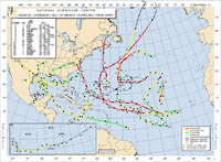
The 2003 Atlantic hurricane season was an active Atlantic hurricane season with tropical activity before and after the official bounds of the season – the first such occurrence in 50 years. The season produced 21 tropical cyclones, of which 16 developed into named storms; seven...
was an active Atlantic hurricane season with tropical activity before and after the official bounds of the season – the first such occurrence in 50 years. The season officially began on June 1, 2003 and ended on November 30. However, a pre-season storm, Tropical Storm Ana
Tropical Storm Ana (2003)
Tropical Storm Ana was the only tropical cyclone on record in the Atlantic basin to form during the month of April. The first tropical cyclone of the season, it developed as a subtropical cyclone from a non-tropical low on April 20 to the west of Bermuda...
, led to the season starting on April 20, and storm activity continued through December 11. The timeline includes information which was not operationally released, meaning that information from post-storm reviews by the National Hurricane Center
National Hurricane Center
The National Hurricane Center , located at Florida International University in Miami, Florida, is the division of the National Weather Service responsible for tracking and predicting weather systems within the tropics between the Prime Meridian and the 140th meridian west poleward to the 30th...
, such as information on a storm that was not operationally warned upon, has been included. This timeline documents tropical cyclone
Tropical cyclone
A tropical cyclone is a storm system characterized by a large low-pressure center and numerous thunderstorms that produce strong winds and heavy rain. Tropical cyclones strengthen when water evaporated from the ocean is released as the saturated air rises, resulting in condensation of water vapor...
formations, strengthening, weakening, landfalls
Landfall (meteorology)
Landfall is the event of a tropical cyclone or a waterspout coming onto land after being over water. When a waterspout makes landfall it is reclassified as a tornado, which can then cause damage inland...
, extratropical transitions, as well as dissipations during the season.
This season had 21 tropical depressions, 16 named storms, 7 hurricanes, and 3 major hurricanes
Tropical cyclone scales
Tropical systems are officially ranked on one of several tropical cyclone scales according to their maximum sustained winds and in what oceanic basin they are located...
, i.e. those that rank as Category 3 or higher on the Saffir-Simpson Hurricane Scale
Saffir-Simpson Hurricane Scale
The Saffir–Simpson Hurricane Scale , or the Saffir–Simpson Hurricane Wind Scale , classifies hurricanes — Western Hemisphere tropical cyclones that exceed the intensities of tropical depressions and tropical storms — into five categories distinguished by the intensities of their sustained winds...
. Hurricane Fabian
Hurricane Fabian
Hurricane Fabian was a powerful Cape Verde-type hurricane that hit Bermuda in early September during the 2003 Atlantic hurricane season. Fabian, the sixth named storm, fourth hurricane, and first major hurricane of the season, developed from a tropical wave in the tropical Atlantic Ocean on August 25...
, Hurricane Isabel
Hurricane Isabel
Hurricane Isabel was the costliest and deadliest hurricane in the 2003 Atlantic hurricane season. The ninth named storm, fifth hurricane, and second major hurricane of the season, Isabel formed near the Cape Verde Islands from a tropical wave on September 6 in the tropical Atlantic Ocean...
, and Hurricane Juan
Hurricane Juan
Hurricane Juan was a significant hurricane that struck the southern part of Atlantic Canada in late September 2003. It was the tenth named storm and the sixth hurricane of the 2003 Atlantic hurricane season. Juan formed southeast of Bermuda on September 24, 2003 out of a tropical wave that tracked...
had their names retired due to the impact caused in Bermuda
Bermuda
Bermuda is a British overseas territory in the North Atlantic Ocean. Located off the east coast of the United States, its nearest landmass is Cape Hatteras, North Carolina, about to the west-northwest. It is about south of Halifax, Nova Scotia, Canada, and northeast of Miami, Florida...
, the eastern United States
United States
The United States of America is a federal constitutional republic comprising fifty states and a federal district...
, and Nova Scotia
Nova Scotia
Nova Scotia is one of Canada's three Maritime provinces and is the most populous province in Atlantic Canada. The name of the province is Latin for "New Scotland," but "Nova Scotia" is the recognized, English-language name of the province. The provincial capital is Halifax. Nova Scotia is the...
respectively. Both Fabian and Juan were the worst hurricanes to hit their respective areas, causing $450 million in damages and 16 fatalities. Hurricane Isabel was the strongest, deadliest, and costliest storm of the season. Isabel peaked as a Category 5 hurricane over the open waters of the Atlantic; however, it weakened to a Category 2 before impacting the east coast of the United States, causing $3.6 billion in damages and 51 fatalities.
April
April 20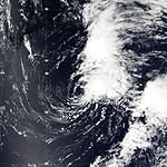
- 2 a.m. EDT (0600 UTCCoordinated Universal TimeCoordinated Universal Time is the primary time standard by which the world regulates clocks and time. It is one of several closely related successors to Greenwich Mean Time. Computer servers, online services and other entities that rely on having a universally accepted time use UTC for that purpose...
) – Subtropical Storm AnaTropical Storm Ana (2003)Tropical Storm Ana was the only tropical cyclone on record in the Atlantic basin to form during the month of April. The first tropical cyclone of the season, it developed as a subtropical cyclone from a non-tropical low on April 20 to the west of Bermuda...
develops out of an extratropical lowExtratropical cycloneExtratropical cyclones, sometimes called mid-latitude cyclones or wave cyclones, are a group of cyclones defined as synoptic scale low pressure weather systems that occur in the middle latitudes of the Earth having neither tropical nor polar characteristics, and are connected with fronts and...
250 miles (400 km)The figures for maximum sustained windMaximum sustained windThe maximum sustained winds associated with a tropical cyclone are a common indicator of the intensity of the storm. Within a mature tropical cyclone, they are found within the eyewall at a distance defined as the radius of maximum wind, or RMW. Unlike gusts, the value of these winds are...
s and position estimates are rounded to the nearest 5 units (knots, miles, or kilometers), following the convention used in the National Hurricane CenterNational Hurricane CenterThe National Hurricane Center , located at Florida International University in Miami, Florida, is the division of the National Weather Service responsible for tracking and predicting weather systems within the tropics between the Prime Meridian and the 140th meridian west poleward to the 30th...
's operational products for each storm. All other units are rounded to the nearest digit. west of BermudaBermudaBermuda is a British overseas territory in the North Atlantic Ocean. Located off the east coast of the United States, its nearest landmass is Cape Hatteras, North Carolina, about to the west-northwest. It is about south of Halifax, Nova Scotia, Canada, and northeast of Miami, Florida...
. - 8 p.m. EDT (0000 UTC April 21) – Subtropical Storm Ana gains tropical characteristics and becomes Tropical Storm Ana.
April 24
- 2 a.m. EDT (0600 UTC) – Tropical Storm Ana loses tropical characteristics and becomes extratropical.
June
June 1- The Atlantic hurricane season officially begins.
June 10
- 8 p.m. ASTUTC-4UTC−04-00 is an identifier for a time offset from UTC of −04.This offset is used in the Atlantic Standard Time Zone in Canada and the North American Eastern Time Zone during daylight saving time , in the Caribbean region this is considered as the Eastern Caribbean timezone...
(0000 June 11) – Tropical Depression Two forms 1,145 mi (1,840 km) southwest of Brava, Cape VerdeBrava, Cape VerdeBrava is an island in Cape Verde. It is the smallest inhabited island, but at the same time the greenest, of Cape Verde, in the Sotavento group. First settled in the 1540s, its population grew after Mount Fogo on neighbouring Fogo erupted in 1675...
.
June 11
- 8 p.m. AST (0000 June 12) – Tropical Depression Two dissipates over open waters.
June 29
- 1 a.m. CDT (0600 UTC) A Tropical Depression forms 210 mi west-northwest of Cancun, Mexico.
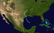
- 7 a.m. CDT (1200 UTC) – The Tropical Depression strengthens into Tropical Storm BillTropical Storm Bill (2003)Tropical Storm Bill was a tropical storm that affected the Gulf Coast of the United States in the summer of 2003. The second storm of the 2003 Atlantic hurricane season, Bill developed from a tropical wave on June 29 to the north of the Yucatán Peninsula...
.
June 30
- 2 p.m. CDT (1900 UTC) – Tropical Storm Bill makes landfall near Cocodrie, LouisianaCocodrie, LouisianaCocodrie is an unincorporated fishing, shrimping and crabbing village in Terrebonne Parish, Louisiana, United States, ten miles south of Chauvin, due south of the larger town of Houma. It is part of the Houma–Bayou Cane–Thibodaux Metropolitan Statistical Area...
with winds of 60 mph (95 km/h).
July
July 1- 1 a.m. CDT (0600 UTC) – Tropical Storm Bill is downgraded to a tropical depression.
July2
- 7 p.m. CDT (1800 UTC) – Tropical Depression Bill loses tropical characteristics and becomes extratropical.
July 8
- 8 p.m. AST (1800 UTC) – Tropical Storm ClaudetteHurricane Claudette (2003)Hurricane Claudette was the third tropical storm and first hurricane of the 2003 Atlantic hurricane season. A fairly long-lived July Atlantic hurricane, Claudette began as a tropical wave in the eastern Caribbean. It moved quickly westward, brushing past the Yucatán Peninsula before moving...
develops out of a tropical waveTropical waveTropical waves, easterly waves, or tropical easterly waves, also known as African easterly waves in the Atlantic region, are a type of atmospheric trough, an elongated area of relatively low air pressure, oriented north to south, which move from east to west across the tropics causing areas of...
located 150 mi (240 km) north of ArubaArubaAruba is a 33 km-long island of the Lesser Antilles in the southern Caribbean Sea, located 27 km north of the coast of Venezuela and 130 km east of Guajira Peninsula...
.
July 10
- 8 a.m. EDT (1200 UTC) – Tropical Storm Claudette intensifies into a hurricane in the western Caribbean SeaCaribbean SeaThe Caribbean Sea is a sea of the Atlantic Ocean located in the tropics of the Western hemisphere. It is bounded by Mexico and Central America to the west and southwest, to the north by the Greater Antilles, and to the east by the Lesser Antilles....
. - 2 p.m. EDT (1800 UTC) – Hurricane Claudette weakens back to a tropical storm.
July 11

- 5 a.m. CDT (1000 UTC) – Tropical Storm Claudette makes landfall near Puerto Morelos, Mexico with winds of 60 mph (95 km/h).
July 15
- 1 a.m. CDT (0600 UTC) – Tropical Storm Claudette re-intensifies into a hurricane in the northwestern Gulf of MexicoGulf of MexicoThe Gulf of Mexico is a partially landlocked ocean basin largely surrounded by the North American continent and the island of Cuba. It is bounded on the northeast, north and northwest by the Gulf Coast of the United States, on the southwest and south by Mexico, and on the southeast by Cuba. In...
. - 10:30 a.m. CDT (1530 UTC) – Hurricane Claudette makes landfall near Matagorda Island, Texas with winds of 90 mph (145 km/h).
- 7 p.m. CDT (0000 UTC July 16 UTC) – Hurricane Claudette weakens to a tropical storm.
July 16
- 8 a.m. AST (1200 UTC) – Tropical Depression Four forms 635 mi (1,020 km) east of BermudaBermudaBermuda is a British overseas territory in the North Atlantic Ocean. Located off the east coast of the United States, its nearest landmass is Cape Hatteras, North Carolina, about to the west-northwest. It is about south of Halifax, Nova Scotia, Canada, and northeast of Miami, Florida...
. - 7 p.m. CDT (0000 UTC July 17 UTC) – Tropical Storm Claudette weakens to a tropical depression.
- 8 p.m. AST (0000 UTC July 17 UTC) – Tropical Depression Four strengthens into Tropical Storm DannyHurricane Danny (2003)Hurricane Danny was the fourth tropical storm and second hurricane of the 2003 Atlantic hurricane season. Forming from a tropical wave at a high latitude on July 16, Danny initially was not expected to strengthen past minimal storm intensity...
.
July 17
- 1 a.m. CDT (0600 UTC) – Tropical Depression Claudette degenerates into a remnant low-pressure areaLow pressure areaA low-pressure area, or "low", is a region where the atmospheric pressure at sea level is below that of surrounding locations. Low-pressure systems form under areas of wind divergence which occur in upper levels of the troposphere. The formation process of a low-pressure area is known as...
.
July 18
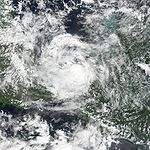
-_close_up.jpg)
- 2 p.m. AST (1800 UTC) – Tropical Storm Danny strengthens into a hurricane.
July 19
- 2 p.m. AST (1800 UTC) – Hurricane Danny weakens to a tropical storm.
- 2 p.m. AST (1800 UTC) – Tropical Depression Six forms 1035 mi (1675 km) east of the Lesser AntillesLesser AntillesThe Lesser Antilles are a long, partly volcanic island arc in the Western Hemisphere. Most of its islands form the eastern boundary of the Caribbean Sea with the Atlantic Ocean, with the remainder located in the southern Caribbean just north of South America...
.
July 20
- 2 p.m. AST (1800 UTC) – Tropical Storm Danny weakens to a tropical depression.
July 21
- 2 a.m. AST (0600 UTC) – Tropical Depression Danny degenerates into a remnant low-pressure area.
- 2 p.m. AST (1800 UTC) – Tropical Depression Six dissipates over open waters.
July 25
- 8 p.m. EDT (1200 UTC) – Tropical Depression SevenTropical Depression Seven (2003)Tropical Depression Seven of the 2003 Atlantic hurricane season was a weak tropical depression that formed off the northeast Florida coast. The seventh tropical cyclone of the season, the depression formed on July 25 from the same tropical wave that spawned previous Tropical Depression Six...
forms 60 mi (95 km) east of Daytona BeachDaytona Beach, FloridaDaytona Beach is a city in Volusia County, Florida, USA. According to 2008 U.S. Census Bureau estimates, the city has a population of 64,211. Daytona Beach is a principal city of the Deltona – Daytona Beach – Ormond Beach, Florida Metropolitan Statistical Area, which the census bureau estimated had...
, FloridaFloridaFlorida is a state in the southeastern United States, located on the nation's Atlantic and Gulf coasts. It is bordered to the west by the Gulf of Mexico, to the north by Alabama and Georgia and to the east by the Atlantic Ocean. With a population of 18,801,310 as measured by the 2010 census, it...
.
July 26
- 2 a.m. EDT (0600 UTC) – Tropical Depression Seven makes landfall near St. Catherines IslandSt. Catherines IslandSt. Catherines Island, also known as Santa Catalina, is one of the Sea Islands or Golden Isles on the coast of the U.S. state of Georgia, 50 miles south of Savannah in Liberty County. The island is ten miles long and from one to three miles wide, located between St. Catherine's Sound and Sapelo...
, GeorgiaGeorgia (U.S. state)Georgia is a state located in the southeastern United States. It was established in 1732, the last of the original Thirteen Colonies. The state is named after King George II of Great Britain. Georgia was the fourth state to ratify the United States Constitution, on January 2, 1788...
with winds of 30 mph (45 km/h).
July 27
- 2 a.m. EDT (0600 UTC) – Tropical Depression Seven dissipates inland.
August
August 14- 8 p.m. EDT (1800 UTC) – Tropical Storm ErikaHurricane Erika (2003)Hurricane Erika was a weak hurricane that struck extreme northeastern Mexico near the Texas-Tamaulipas border in mid-August of the 2003 Atlantic hurricane season. Erika was the eighth tropical cyclone, fifth tropical storm, and third hurricane of the season...
develops out of an area of low pressure about 85 mi (140 km) west-southwest of Fort MyersFort Myers, FloridaFort Myers is the county seat and commercial center of Lee County, Florida, United States. Its population was 62,298 in the 2010 census, a 29.23 percent increase over the 2000 figure....
, FloridaFloridaFlorida is a state in the southeastern United States, located on the nation's Atlantic and Gulf coasts. It is bordered to the west by the Gulf of Mexico, to the north by Alabama and Georgia and to the east by the Atlantic Ocean. With a population of 18,801,310 as measured by the 2010 census, it...
.
August 16
- 5:30 a.m. CDT (1030 UTC) – Tropical Storm Erika strengthens into a hurricane and makes landfall near Boca San Rafael, Mexico in northeastern TamaulipasTamaulipasTamaulipas officially Estado Libre y Soberano de Tamaulipas is one of the 31 states which, with the Federal District, comprise the 32 Federal Entities of Mexico. It is divided in 43 municipalities and its capital city is Ciudad Victoria. The capital city was named after Guadalupe Victoria, the...
with winds of 75 mph (120 km/h) - 1 p.m. CDT (1800 UTC) – Hurricane Erika weakens to a tropical storm.
- 7 p.m. CDT (0000 UTC August 17) – Tropical Storm Erika weakens to a tropical depression.
August 17

- 1 a.m. CDT (0600 UTC) – Tropical Depression Erika dissipates over the mountains of northern MexicoMexicoThe United Mexican States , commonly known as Mexico , is a federal constitutional republic in North America. It is bordered on the north by the United States; on the south and west by the Pacific Ocean; on the southeast by Guatemala, Belize, and the Caribbean Sea; and on the east by the Gulf of...
.
August 21
- 8 a.m. AST (1200 UTC) – Tropical Depression NineTropical Depression Nine (2003)Tropical Depression Nine was a weak tropical depression that developed and dissipated in the eastern Caribbean Sea in August 2003. It formed from a tropical wave on August 21 to the south of Puerto Rico, and was initially forecast to strengthen to tropical storm status, due to the favorable...
forms about 260 mi (415 km) south of San JuanSan Juan, Puerto RicoSan Juan , officially Municipio de la Ciudad Capital San Juan Bautista , is the capital and most populous municipality in Puerto Rico, an unincorporated territory of the United States. As of the 2010 census, it had a population of 395,326 making it the 46th-largest city under the jurisdiction of...
, Puerto RicoPuerto RicoPuerto Rico , officially the Commonwealth of Puerto Rico , is an unincorporated territory of the United States, located in the northeastern Caribbean, east of the Dominican Republic and west of both the United States Virgin Islands and the British Virgin Islands.Puerto Rico comprises an...
.
August 22
- 2 p.m. AST (1800 UTC) – Tropical Depression Nine dissipates over open waters.
August 27
- 2 p.m. AST (1800 UTC) – Tropical Depression Ten forms 420 mi (675 km) west of the Cape VerdeCape VerdeThe Republic of Cape Verde is an island country, spanning an archipelago of 10 islands located in the central Atlantic Ocean, 570 kilometres off the coast of Western Africa...
Islands.
August 28
- 8 a.m. AST (1200 UTC) – Tropical Depression Ten strengthens into Tropical Storm FabianHurricane FabianHurricane Fabian was a powerful Cape Verde-type hurricane that hit Bermuda in early September during the 2003 Atlantic hurricane season. Fabian, the sixth named storm, fourth hurricane, and first major hurricane of the season, developed from a tropical wave in the tropical Atlantic Ocean on August 25...
.
August 29
- 8 p.m. AST (0000 UTC August 30) – Tropical Storm Fabian intensifies into a hurricane.
August 30
- 8 a.m. AST (1200 UTC) –Hurricane Fabian strengthens into a Category 2 hurricane.
- 7 a.m. PDT (1200 UTC) – Tropical Depression Eleven forms 335 mi (540 km) east-southeast of Corpus Christi, TexasCorpus Christi, TexasCorpus Christi is a coastal city in the South Texas region of the U.S. state of Texas. The county seat of Nueces County, it also extends into Aransas, Kleberg, and San Patricio counties. The MSA population in 2008 was 416,376. The population was 305,215 at the 2010 census making it the...
. - 2 p.m. AST (1800 UTC) – Hurricane Fabian strengthens into a major hurricane—a storm with winds of 111 mph (178 km/h) or higher.
- 1 p.m. PDT (1800 UTC) – Tropical Depression Eleven strengthens into Tropical Storm GraceTropical Storm Grace (2003)Tropical Storm Grace was a weak tropical storm that struck Texas in the 2003 Atlantic hurricane season. The eleventh tropical depression and the seventh tropical storm of the season, Grace was also the weakest storm of the season. On August 30 the storm developed from a long-track tropical wave in...
.
August 31
- 6 a.m. PDT (1100 UTC) – Tropical Storm Grace makes landfall near Galveston IslandGalveston IslandGalveston Island is a barrier island on the Texas Gulf coast in the United States, about 50 miles southeast of Houston. The entire island, with the exception of Jamaica Beach, is within the city limits of the City of Galveston....
, TexasTexasTexas is the second largest U.S. state by both area and population, and the largest state by area in the contiguous United States.The name, based on the Caddo word "Tejas" meaning "friends" or "allies", was applied by the Spanish to the Caddo themselves and to the region of their settlement in...
with winds of 40 mph (65 km/h). - 2 p.m. AST (1800 UTC) – Hurricane Fabian strengthens into a Category 4 hurricane.
- 1 p.m. PDT (1800 UTC) – Tropical Storm Grace weakens to a tropical depression.
September
September 1- 2 p.m. AST (1800 UTC) – Hurricane Fabian reaches its peak intensity with winds of 145 mph (230 km/h) while located 310 mi (500 km) northeast of BarbudaBarbudaBarbuda is an island in the Eastern Caribbean, and forms part of the state of Antigua and Barbuda. It has a population of about 1,500, most of whom live in the town of Codrington.-Location:...
.
September 2
- 7 a.m. CDT (1200 UTC) – Tropical Depression Grace dissipates as it gets absorbed by a frontal system.
September 3

- 2 a.m. AST (0600 UTC) – Hurricane Fabian weakens to a Category 3 hurricane.
- 2 p.m. EDT (1800 UTC) – Tropical Depression Twelve forms 300 mi (480 km) west of Tampa, FloridaTampa, FloridaTampa is a city in the U.S. state of Florida. It serves as the county seat for Hillsborough County. Tampa is located on the west coast of Florida. The population of Tampa in 2010 was 335,709....
. - 8 p.m. AST (0000 UTC September 4) – Hurricane Fabian re-intensifies into a Category 4 hurricane.
September 4
- 2 a.m. AST (0600 UTC) – Hurricane Fabian weakens to a Category 3 hurricane again.
- 8 p.m. AST (0000 UTC September 5) – Hurricane Fabian re-intensifies into a Category 4 hurricane.
September 5
- 2 a.m. AST (0600 UTC) – Hurricane Fabian weakens to a Category 3 hurricane once more.
- 2 a.m. EDT (0600 UTC) – Tropical Depression Twelve strengthens into Tropical Storm HenriTropical Storm Henri (2003)Tropical Storm Henri was weak a tropical storm that formed in the 2003 Atlantic hurricane season. The eighth storm of the season, Henri was one of six tropical cyclones to hit the United States in the year. Henri formed from a tropical wave in the Gulf of Mexico in early September, and crossed over...
. - 4 p.m. AST (2000 UTC) – Hurricane Fabian makes its closest approach to land, passing 14 mi (23 km) to the west of Bermuda with winds of 115 mph (180 km/h).
- 8 p.m. EDT (0000 UTC September 6) – Tropical Storm Henri weakens to a tropical depression.
- 8 p.m. AST (0000 UTC September 6) – Tropical Depression Thirteen forms 470 mi (755 km) west-southwest of Brava, Cape Verde.
September 6
- 2 a.m. AST (0600 UTC) – Tropical Depression Thirteen strengthens into Tropical Storm IsabelHurricane IsabelHurricane Isabel was the costliest and deadliest hurricane in the 2003 Atlantic hurricane season. The ninth named storm, fifth hurricane, and second major hurricane of the season, Isabel formed near the Cape Verde Islands from a tropical wave on September 6 in the tropical Atlantic Ocean...
. - 5 a.m. EDT (0900 UTC) – Tropical Depression Henri makes landfall near Clearwater, FloridaClearwater, FloridaClearwater is a city located in Pinellas County, Florida, US, nearly due west of Tampa and northwest of St. Petersburg. In the west of Clearwater lies the Gulf of Mexico and in the east lies Tampa Bay. As of the 2000 census, the city had a total population of 108,787. It is the county seat of...
with winds of 35 mph (55 km/h). - 8 p.m. AST (0000 UTC September 7) – Hurricane Fabian weakens into a Category 2 hurricane.
September 7
- 8 a.m. AST (1200 UTC) – Hurricane Fabian weakens to a Category 1 hurricane.
- 8 a.m. AST (1200 UTC) – Tropical Storm Isabel strengthens into a hurricane.
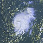
September 8
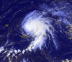
.jpg)
- 2 a.m. AST (0600 UTC) – Hurricane Isabel strengthens into a Category 2 hurricane.
- 2 a.m. AST (0600 UTC) – Tropical Depression Fourteen forms 290 mi (465 km) southeast of the southernmost Cape Verde islands.
- 8 a.m. AST (1200 UTC) – Hurricane Isabel strengthens into a major hurricane.
- 2 p.m. AST (1800 UTC) – Hurricane Fabian loses tropical characteristics and becomes extratropical, while retaining hurricane-force winds, over the open waters of the north Atlantic OceanAtlantic OceanThe Atlantic Ocean is the second-largest of the world's oceanic divisions. With a total area of about , it covers approximately 20% of the Earth's surface and about 26% of its water surface area...
. - 2 p.m. EDT (1800 UTC) – Tropical Depression Henri loses tropical characteristics and becomes extratropical shortly before dissipating.
- 8 p.m. AST (0000 UTC September 9) – Hurricane Isabel strengthens into a Category 4 hurricane.
September 9
- 8 p.m. AST (0000 UTC September 10) – Hurricane Isabel weakens to a Category 3 hurricane.
September 10
- 8 a.m. AST (1200 UTC) – Hurricane Isabel re-intensifies into a Category 4 hurricane.
- 2 p.m. AST (1800 UTC) – Tropical Depression Fourteen dissipates.
September 11
- 2 p.m. AST (1800 UTC) – Hurricane Isabel strengthens into a Category 5 hurricane, becoming the strongest storm of the season; winds peak at 165 mph (270 km/h) and the minimum pressure is 915 mbarBar (unit)The bar is a unit of pressure equal to 100 kilopascals, and roughly equal to the atmospheric pressure on Earth at sea level. Other units derived from the bar are the megabar , kilobar , decibar , centibar , and millibar...
(hPaPascal (unit)The pascal is the SI derived unit of pressure, internal pressure, stress, Young's modulus and tensile strength, named after the French mathematician, physicist, inventor, writer, and philosopher Blaise Pascal. It is a measure of force per unit area, defined as one newton per square metre...
; (27.03 inHg). At this time, Isabel is located 560 mi (900 km) northeast of GuadeloupeGuadeloupeGuadeloupe is an archipelago located in the Leeward Islands, in the Lesser Antilles, with a land area of 1,628 square kilometres and a population of 400,000. It is the first overseas region of France, consisting of a single overseas department. As with the other overseas departments, Guadeloupe...
.
September 12

- 8 p.m. AST (0000 UTC September 13) – Hurricane Isabel weakens to a Category 4 hurricane.
September 13
- 2 p.m. AST (1800 UTC) – Hurricane Isabel re-intensifies into a Category 5 hurricane.
- 8 p.m. AST (0000 UTC September 14) – Hurricane Isabel weakens to a Category 4 hurricane again.
September 14
- 2 p.m. AST (1800 UTC) – Hurricane Isabel re-intensifies into a Category 5 hurricane for the third and final time.
- 8 p.m. AST (0000 UTC September 15) – Hurricane Isabel weakens to a Category 4 hurricane once more.
September 15
- 8 p.m. EST (0000 UTC September 16) – Hurricane Isabel weakens to a Category 3 hurricane.
September 16
- 8 a.m. (1200 UTC) – Hurricane Isabel weakens to a Category 2 hurricane.
September 18
- 1 p.m. EST (1700 UTC) – Hurricane Isabel makes landfall near Drum Inlet, North Carolina with winds of 105 mph (165 km/h).
- 8 p.m. EST (0000 UTC September 19) – Hurricane Isabel weakens to a Category 1 hurricane.
September 19
- 2 a.m. EST (0600 UTC) – Hurricane Isabel weakens to a tropical storm.
- 8 a.m. EST (1200 UTC) – Tropical Storm Isabel loses tropical characteristics and becomes extratropical.
September 24
- 8 a.m. AST (1200 UTC) – Tropical Depression Fifteen forms 345 mi (555 km) southeast of Bermuda.
- 8 p.m. AST (0000 UTC September 25) – Tropical Depression Fifteen strengthens into Tropical Storm JuanHurricane JuanHurricane Juan was a significant hurricane that struck the southern part of Atlantic Canada in late September 2003. It was the tenth named storm and the sixth hurricane of the 2003 Atlantic hurricane season. Juan formed southeast of Bermuda on September 24, 2003 out of a tropical wave that tracked...
.
September 25
- 2 p.m AST (1800 UTC) – Tropical Depression Sixteen forms 920 mi (1,480 km) west-southwest of the Cape Verde Islands.
September 26
- 8 a.m. AST (1200 UTC) – Tropical Storm Juan strengthens into a hurricane.
September 27

- 2 p.m. AST (1800 UTC) – Hurricane Juan strengthens into a Category 2 hurricane.
- 2 p.m. AST (1800 UTC) – Tropical Depression Sixteen strengthens into Tropical Storm KateHurricane Kate (2003)Hurricane Kate was the second-longest tropical cyclone in the 2003 Atlantic hurricane season. The eleventh tropical storm, fifth hurricane, and third major hurricane of the season, Kate developed from a tropical wave in the central tropical Atlantic on September 25. Its unusual track included four...
.
September 28
- 11 p.m. AST (0300 UTC September 29) – Hurricane Juan makes landfall near Halifax, Nova Scotia with winds of 100 mph (160 km/h).
September 29
- 2 a.m. AST (0600 UTC) – Hurricane Juan weakens to a Category 1 hurricane as it passes over Prince Edward IslandPrince Edward IslandPrince Edward Island is a Canadian province consisting of an island of the same name, as well as other islands. The maritime province is the smallest in the nation in both land area and population...
with winds of 75 mph (120 km/h). - 8 a.m. AST (1200 UTC) – Hurricane Juan weakens to a tropical storm.
- 2 p.m. AST (1800 UTC) – Tropical Storm Juan is absorbed by a large extratropical low.
- 2 p.m. AST (1800 UTC) – Tropical Storm Kate strengthens into a hurricane.
September 30
- 2 a.m. AST (0600 UTC) – Hurricane Kate weakens to a tropical storm.
October
October 1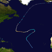
- 2 p.m. AST (1800 UTC) – Tropical Storm Kate re-intensifies into a hurricane.
- 1 p.m. CDT (1800 UTC) – Tropical Storm LarryTropical Storm Larry (2003)Tropical Storm Larry was the twelfth tropical storm in the 2003 Atlantic hurricane season. It was one of eight storms to impact Mexico from either the Pacific or Atlantic Oceans in the season, a near-record. Larry formed in early October from an extratropical storm in the Bay of Campeche, and...
develops out of an extratropical gale while located 300 mi (483 km) east-southeast of TampicoTampicoTampico is a city and port in the state of Tamaulipas, in the country of Mexico. It is located in the southeastern part of the state, directly north across the border from Veracruz. Tampico is the third largest city in Tamaulipas, and counts with a population of 309,003. The Metropolitan area of...
, MexicoMexicoThe United Mexican States , commonly known as Mexico , is a federal constitutional republic in North America. It is bordered on the north by the United States; on the south and west by the Pacific Ocean; on the southeast by Guatemala, Belize, and the Caribbean Sea; and on the east by the Gulf of...
.
October 3
- 2 a.m. AST (0600 UTC) – Hurricane Kate strengthens into a Category 2 hurricane.
- 2 p.m. AST (1800 UTC) – Hurricane Kate strengthens into a major hurricane.
October 4
- 2 p.m. AST (1800 UTC) – Hurricane Kate reaches its peak intensity with winds of 125 mph (205 km/h) with a minimum pressure of 952 mbar (hPa; 28.12 inHg) while located 645 mi (1,040 km) southeast of Bermuda.
October 5
- 2 a.m. AST (0600 UTC) – Hurricane Kate weakens to a Category 2 hurricane.
- 5 a.m. CDT (1000 UTC) – Tropical Storm Larry makes landfall near ParaísoParaíso, TabascoParaíso is a town in the Mexican state of Tabasco. It is located near the Grijalva River in the subregion of Chontalpa.Paraíso is 577.55 km², which corresponds to 1.5% of the entire country. It is the seventeenth largest territory in Mexico...
in the MexicanMexicoThe United Mexican States , commonly known as Mexico , is a federal constitutional republic in North America. It is bordered on the north by the United States; on the south and west by the Pacific Ocean; on the southeast by Guatemala, Belize, and the Caribbean Sea; and on the east by the Gulf of...
state of TabascoTabascoTabasco officially Estado Libre y Soberano de Tabasco is one of the 31 states which, with the Federal District, comprise the 32 Federal Entities of Mexico. It is divided in 17 municipalities and its capital city is Villahermosa....
with winds of 60 mph (95 km/h). - 8 p.m. AST (0000 UTC October 6) – Hurricane Kate weakens to a Category 1 hurricane.
October 6
- 1 a.m. CDT (0600 UTC) – Tropical Storm Larry weakens to a tropical depression.
- 7 a.m. CDT (1200 UTC) – Tropical Depression Larry degenerates into a remnant low-pressure area.
October 7
- 2 a.m. AST (0600 UTC) – Hurricane Kate weakens to a tropical storm.
- 8 p.m. AST (0000 UTC October 8) – Tropical Storm Kate loses tropical characteristics and becomes extratropical over the northern Atlantic Ocean while located several hundred miles northeast of NewfoundlandNewfoundland and LabradorNewfoundland and Labrador is the easternmost province of Canada. Situated in the country's Atlantic region, it incorporates the island of Newfoundland and mainland Labrador with a combined area of . As of April 2011, the province's estimated population is 508,400...
.
October 10
- 2 p.m. AST (1800 UTC) – Tropical Storm Mindy forms 80 mi (130 km) northeast of Santo DomingoSanto DomingoSanto Domingo, known officially as Santo Domingo de Guzmán, is the capital and largest city in the Dominican Republic. Its metropolitan population was 2,084,852 in 2003, and estimated at 3,294,385 in 2010. The city is located on the Caribbean Sea, at the mouth of the Ozama River...
, Dominican RepublicDominican RepublicThe Dominican Republic is a nation on the island of La Hispaniola, part of the Greater Antilles archipelago in the Caribbean region. The western third of the island is occupied by the nation of Haiti, making Hispaniola one of two Caribbean islands that are shared by two countries...
.
October 12
- 2 a.m. AST (0600 UTC) – Tropical Storm Mindy weakens to a tropical depression.
- 8 p.m. AST (0000 UTC October 13) – Tropical Depression Nineteen forms 1,030 mi (1,660 km) west-southwest of the Cape Verde islands.
October 14
- 2 a.m. AST (0600 UTC) – Tropical Depression Mindy dissipates.
- 2 p.m. AST (1800 UTC) – Tropical Depression Nineteen strengthens into Tropical Storm NicholasTropical Storm Nicholas (2003)Tropical Storm Nicholas was a long-lived tropical storm in October and November of the 2003 Atlantic hurricane season. Forming from a tropical wave on October 13 in the central tropical Atlantic Ocean, Nicholas slowly developed due to moderate levels of wind shear throughout its lifetime...
.
October 22
- 8 p.m. AST (0000 UTC October 23) – Tropical Storm Nicholas weakens to a tropical depression.
October 23
- 8 p.m. AST (0000 UTC October 24) – Tropical Depression Nicholas degenerates into a broad area of low pressure while located 605 mi (975 km) northeast of BarbudaBarbudaBarbuda is an island in the Eastern Caribbean, and forms part of the state of Antigua and Barbuda. It has a population of about 1,500, most of whom live in the town of Codrington.-Location:...
.
December
December 4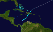
- 8 a.m. AST (1200 UTC) – Tropical Depression Twenty forms about 345 mi (560 km) south of Kingston, JamaicaKingston, JamaicaKingston is the capital and largest city of Jamaica, located on the southeastern coast of the island. It faces a natural harbour protected by the Palisadoes, a long sand spit which connects the town of Port Royal and the Norman Manley International Airport to the rest of the island...
. - 2 p.m. AST (1800 UTC) – Tropical Depression Twenty strengthens into Tropical Storm OdetteTropical Storm Odette (2003)Tropical Storm Odette was a rare off-season tropical storm that affected the Caribbean Sea in December 2003. The 15th tropical storm of the 2003 Atlantic hurricane season, Odette formed near the coast of Panama a few days after the official end of the Atlantic hurricane season, and ultimately made...
.
December 6
- 7 p.m. AST (2300 UTC) – Tropical Storm Odette makes landfall near Cabo Falso, Dominican Republic with winds of 60 mph (95 km/h).
December 7
- 2 p.m. AST (1800 UTC) – Tropical Storm Odette loses tropical characteristics and becomes extratropical.
- 2 p.m. AST (1800 UTC) – Subtropical Storm Peter forms 835 mi (1,340 km) south-southwest of the AzoresAzoresThe Archipelago of the Azores is composed of nine volcanic islands situated in the middle of the North Atlantic Ocean, and is located about west from Lisbon and about east from the east coast of North America. The islands, and their economic exclusion zone, form the Autonomous Region of the...
.
December 9
- 2 a.m. AST (0600 UTC) – Subtropical Storm Peter acquires enough tropical characteristics to be classified a tropical storm.
December 10
- 8 a.m. AST (1200 UTC) – Tropical Storm Peter weakens to a tropical depression.
December 11
- 2 a.m. AST (0600 UTC) – Tropical Depression Peter loses tropical characteristics and becomes extratropical shortly before being absorbed by a frontal system.