

Timeline of the 1992 Atlantic hurricane season
Encyclopedia
The 1992 Atlantic hurricane season
was a below-average season that produced six named tropical cyclone
s. The season officially started on June 1, 1992 and finished on November 30; however, Subtropical Storm One
formed outside the official timeline on April 21. Subtropical Storm One was the first recorded subtropical cyclone to form in April since the recording of subtropical cyclones began in 1968. This timeline documents all the storm formations, strengthening, weakening, landfalls
, extratropical transitions, as well as dissipations during the season.
During the year, three tropical depressions, one subtropical storm, two tropical storms, and four hurricanes formed. It produced seven storms, less than the average of ten usually formed throughout an Atlantic hurricane season, while four of the storms went on to become hurricanes. The first cyclone to form inside the official season was Tropical Depression One
, which formed on June 25. Of the four hurricanes, Hurricane Andrew
was the most intense, reaching Category 5
status. In late June, Tropical Depression One
caused severe flooding in southwestern Florida and Cuba
; heavy rainfall was recorded in Pinar del Rio
, Matanzas
, and Havana. When Andrew struck Florida
and Louisiana
in August, it become the second costliest hurricane to hit the United States
. Damages were estimated to be about $26.5 billion and 68 people were killed. Tropical Storm Danielle
made landfall at the Delmarva Peninsula
on the Virginia
n coast on September 25, causing minimal flooding. There was one recorded death recorded due to Danielle; a ship east of New Jersey
was sunk due to rough seas. The season finished on October 30 when Hurricane Frances
became an extratropical gale before dissipating.
 April 21
April 22
April 23
April 24
June 25
June 26
July 26
 August 16
August 17
August 22
August 23
August 24
August 26
August 28
September 18
September 19
September 21
September 22
September 23
September 24
September 25
September 26
September 27
September 29
September 30
 October 1
October 2
October 3
October 22
October 23
October 25
October 27
October 30
1992 Atlantic hurricane season
The 1992 Atlantic hurricane season had one of the latest dates on record for the first named storm. The season officially began on June 1, 1992, and lasted until November 30, 1992. It was the least active hurricane season in nine years due to a strong El Niño...
was a below-average season that produced six named tropical cyclone
Tropical cyclone
A tropical cyclone is a storm system characterized by a large low-pressure center and numerous thunderstorms that produce strong winds and heavy rain. Tropical cyclones strengthen when water evaporated from the ocean is released as the saturated air rises, resulting in condensation of water vapor...
s. The season officially started on June 1, 1992 and finished on November 30; however, Subtropical Storm One
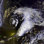
Subtropical Storm One (1992)
Subtropical Storm One in 1992 was the first recorded Atlantic subtropical cyclone during the month of April. It formed on April 21 about 600 miles southeast of Bermuda, and tracking northwestward reached subtropical storm status on April 22. The cyclone attained peak winds of 50 mph ...
formed outside the official timeline on April 21. Subtropical Storm One was the first recorded subtropical cyclone to form in April since the recording of subtropical cyclones began in 1968. This timeline documents all the storm formations, strengthening, weakening, landfalls
Landfall (meteorology)
Landfall is the event of a tropical cyclone or a waterspout coming onto land after being over water. When a waterspout makes landfall it is reclassified as a tornado, which can then cause damage inland...
, extratropical transitions, as well as dissipations during the season.
During the year, three tropical depressions, one subtropical storm, two tropical storms, and four hurricanes formed. It produced seven storms, less than the average of ten usually formed throughout an Atlantic hurricane season, while four of the storms went on to become hurricanes. The first cyclone to form inside the official season was Tropical Depression One
Tropical Depression One (1992)
Tropical Depression One in June 1992 produced 100-year floods in portions of southwestern Florida. The first tropical depression and second tropical cyclone of the 1992 Atlantic hurricane season, the depression developed on June 25 from a tropical wave...
, which formed on June 25. Of the four hurricanes, Hurricane Andrew
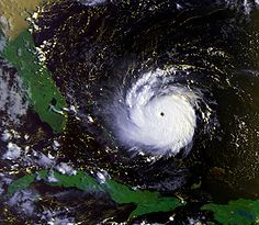
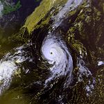
Hurricane Andrew
Hurricane Andrew was the third Category 5 hurricane to make landfall in the United States, after the Labor Day Hurricane of 1935 and Hurricane Camille in 1969. Andrew was the first named storm and only major hurricane of the otherwise inactive 1992 Atlantic hurricane season...
was the most intense, reaching Category 5
Saffir-Simpson Hurricane Scale
The Saffir–Simpson Hurricane Scale , or the Saffir–Simpson Hurricane Wind Scale , classifies hurricanes — Western Hemisphere tropical cyclones that exceed the intensities of tropical depressions and tropical storms — into five categories distinguished by the intensities of their sustained winds...
status. In late June, Tropical Depression One
Tropical Depression One (1992)
Tropical Depression One in June 1992 produced 100-year floods in portions of southwestern Florida. The first tropical depression and second tropical cyclone of the 1992 Atlantic hurricane season, the depression developed on June 25 from a tropical wave...
caused severe flooding in southwestern Florida and Cuba
Cuba
The Republic of Cuba is an island nation in the Caribbean. The nation of Cuba consists of the main island of Cuba, the Isla de la Juventud, and several archipelagos. Havana is the largest city in Cuba and the country's capital. Santiago de Cuba is the second largest city...
; heavy rainfall was recorded in Pinar del Rio
Pinar del Río Province
Pinar del Río is one of the provinces of Cuba. It is at the western end of the island of Cuba.-Geography:The Pinar del Río province is Cuba's westernmost province and contains one of Cuba's three main mountain ranges, the Cordillera de Guaniguanico, divided into the easterly Sierra del Rosario and...
, Matanzas
Matanzas Province
Matanzas is one of the provinces of Cuba. Major towns in the province include Cárdenas, Colón, Jovellanos and the capital of the same name, Matanzas...
, and Havana. When Andrew struck Florida
Florida
Florida is a state in the southeastern United States, located on the nation's Atlantic and Gulf coasts. It is bordered to the west by the Gulf of Mexico, to the north by Alabama and Georgia and to the east by the Atlantic Ocean. With a population of 18,801,310 as measured by the 2010 census, it...
and Louisiana
Louisiana
Louisiana is a state located in the southern region of the United States of America. Its capital is Baton Rouge and largest city is New Orleans. Louisiana is the only state in the U.S. with political subdivisions termed parishes, which are local governments equivalent to counties...
in August, it become the second costliest hurricane to hit the United States
United States
The United States of America is a federal constitutional republic comprising fifty states and a federal district...
. Damages were estimated to be about $26.5 billion and 68 people were killed. Tropical Storm Danielle
Tropical Storm Danielle (1992)
Tropical Storm Danielle was a weak tropical storm that made landfall on Virginia in the 1992 Atlantic hurricane season. The fourth storm of the season, Danielle was one of two Atlantic storms in the year to make landfall in the United States, the other being Hurricane Andrew. It formed out of a...
made landfall at the Delmarva Peninsula
Delmarva Peninsula
The Delmarva Peninsula is a large peninsula on the East Coast of the United States, occupied by most of Delaware and portions of Maryland and Virginia...
on the Virginia
Virginia
The Commonwealth of Virginia , is a U.S. state on the Atlantic Coast of the Southern United States. Virginia is nicknamed the "Old Dominion" and sometimes the "Mother of Presidents" after the eight U.S. presidents born there...
n coast on September 25, causing minimal flooding. There was one recorded death recorded due to Danielle; a ship east of New Jersey
New Jersey
New Jersey is a state in the Northeastern and Middle Atlantic regions of the United States. , its population was 8,791,894. It is bordered on the north and east by the state of New York, on the southeast and south by the Atlantic Ocean, on the west by Pennsylvania and on the southwest by Delaware...
was sunk due to rough seas. The season finished on October 30 when Hurricane Frances
Hurricane Frances
Hurricane Frances was the sixth named storm, the fourth hurricane, and the third major hurricane of the 2004 Atlantic hurricane season. The system crossing the open Atlantic during mid to late August, moving to the north of the Lesser Antilles while strengthening. Its outer bands affected Puerto...
became an extratropical gale before dissipating.
April
- 8 a.m. ASTAtlantic Standard Time ZoneThe Atlantic Standard Time Zone is a geographical region that keeps time by subtracting four hours from either Coordinated Universal Time or Greenwich Mean Time , resulting in UTC-4 or GMT-4...
(1200 UTCCoordinated Universal TimeCoordinated Universal Time is the primary time standard by which the world regulates clocks and time. It is one of several closely related successors to Greenwich Mean Time. Computer servers, online services and other entities that rely on having a universally accepted time use UTC for that purpose...
) – Subtropical Depression OneSubtropical Storm One (1992)Subtropical Storm One in 1992 was the first recorded Atlantic subtropical cyclone during the month of April. It formed on April 21 about 600 miles southeast of Bermuda, and tracking northwestward reached subtropical storm status on April 22. The cyclone attained peak winds of 50 mph ...
forms about 600 miles (965 km) southeast of BermudaBermudaBermuda is a British overseas territory in the North Atlantic Ocean. Located off the east coast of the United States, its nearest landmass is Cape Hatteras, North Carolina, about to the west-northwest. It is about south of Halifax, Nova Scotia, Canada, and northeast of Miami, Florida...
(30 mph, 50 km/h).The figures for maximum sustained windMaximum sustained windThe maximum sustained winds associated with a tropical cyclone are a common indicator of the intensity of the storm. Within a mature tropical cyclone, they are found within the eyewall at a distance defined as the radius of maximum wind, or RMW. Unlike gusts, the value of these winds are...
s and position estimates are rounded to the nearest 5 units (knots, miles, or kilometers), following the convention used in the National Hurricane CenterNational Hurricane CenterThe National Hurricane Center , located at Florida International University in Miami, Florida, is the division of the National Weather Service responsible for tracking and predicting weather systems within the tropics between the Prime Meridian and the 140th meridian west poleward to the 30th...
's operational products for each storm. All other units are rounded to the nearest digit.
April 22
- 2 a.m. AST (0600 UTC) – Subtropical Depression One strengthens into a Subtropical Storm (50 mph, 80 km/h).
April 23
- 2 p.m. AST (1800 UTC) – Subtropical Storm One weakens back into a Subtropical Depression (35 mph, 55 km/h).
April 24
- 8 p.m. AST (0000 UTC April 25) – Subtropical Storm One dissipates.
June
June 1- The 1992 Atlantic hurricane season1992 Atlantic hurricane seasonThe 1992 Atlantic hurricane season had one of the latest dates on record for the first named storm. The season officially began on June 1, 1992, and lasted until November 30, 1992. It was the least active hurricane season in nine years due to a strong El Niño...
officially begins.
June 25
- 6 a.m. CDT (1200 UTC) – Tropical Depression OneTropical Depression One (1992)Tropical Depression One in June 1992 produced 100-year floods in portions of southwestern Florida. The first tropical depression and second tropical cyclone of the 1992 Atlantic hurricane season, the depression developed on June 25 from a tropical wave...
forms 220 mi (355 km) northwest of HavanaHavanaHavana is the capital city, province, major port, and leading commercial centre of Cuba. The city proper has a population of 2.1 million inhabitants, and it spans a total of — making it the largest city in the Caribbean region, and the most populous...
, CubaCubaThe Republic of Cuba is an island nation in the Caribbean. The nation of Cuba consists of the main island of Cuba, the Isla de la Juventud, and several archipelagos. Havana is the largest city in Cuba and the country's capital. Santiago de Cuba is the second largest city...
(30 mph, 50 km/h).
June 26
- 1 p.m. EDTEastern Time ZoneThe Eastern Time Zone of the United States and Canada is a time zone that falls mostly along the east coast of North America. Its UTC time offset is −5 hrs during standard time and −4 hrs during daylight saving time...
(1800 UTC) – Tropical Depression One dissipates over northern FloridaFloridaFlorida is a state in the southeastern United States, located on the nation's Atlantic and Gulf coasts. It is bordered to the west by the Gulf of Mexico, to the north by Alabama and Georgia and to the east by the Atlantic Ocean. With a population of 18,801,310 as measured by the 2010 census, it...
.
July
July 24- 5 p.m. AST (2100 UTC) – Tropical Depression Two forms 305 mi (490 km) southeast of BermudaBermudaBermuda is a British overseas territory in the North Atlantic Ocean. Located off the east coast of the United States, its nearest landmass is Cape Hatteras, North Carolina, about to the west-northwest. It is about south of Halifax, Nova Scotia, Canada, and northeast of Miami, Florida...
(30 mph, 50 km/h).
July 26
- 2 p.m. AST (1800 UTC) – Tropical Depression Two dissipates.
August
- 4 p.m UTC-2UTC-2UTC−02:00 is an identifier for a time offset from UTC of −02. This time is used in:-As standard time :*Brazil - Ocean Islands - Fernando de Noronha, Trindade, Martim Vaz, etc.*South Georgia and the South Sandwich Islands...
(1800 UTC) – Tropical Depression Three forms 775 mi (1,245 km) southwest of Brava, Cape VerdeBrava, Cape VerdeBrava is an island in Cape Verde. It is the smallest inhabited island, but at the same time the greenest, of Cape Verde, in the Sotavento group. First settled in the 1540s, its population grew after Mount Fogo on neighbouring Fogo erupted in 1675...
(30 mph, 50 km/h).
August 17
- 9 a.m. UTC-3UTC-3UTC−03:00 is an identifier for a time offset from UTC of −03:00.-As standard time :*Suriname*Falkland Islands*French Guiana*Brazil - East Northern and Northeastern States...
(1200 UTC) – Tropical Depression Three is upgraded to Tropical Storm Andrew (40 mph, 65 km/h).
August 22
- 7 a.m. EDT (1200 UTC) – Tropical Storm Andrew strengthens into Hurricane AndrewHurricane AndrewHurricane Andrew was the third Category 5 hurricane to make landfall in the United States, after the Labor Day Hurricane of 1935 and Hurricane Camille in 1969. Andrew was the first named storm and only major hurricane of the otherwise inactive 1992 Atlantic hurricane season...
(80 mph, 130 km/h)). - 1 p.m. EDT (1800 UTC) – Hurricane Andrew becomes a Category 2 hurricane (110 mph, 175 km/h).
- 7 p.m. EDT (0000 UTC August 23) – Hurricane Andrew strengthens into a Category 3 hurricane (125 mph, 200 km/h).
August 23
- 1 a.m. EDT (0600 UTC) – Hurricane Andrew becomes a Category 4 hurricane (150 mph, 240 km/h).
- 7 a.m. EDT (1200 UTC) – Hurricane Andrew becomes a Category 5 hurricane (165 mph, 265 km/h).
- 1 p.m. EDT (1800 UTC) – Hurricane Andrew reaches its peak speed (175 mph, 280 km/h).
- 4 p.m. EDT (2100 UTC) – Hurricane Andrew makes landfall at Eleuthera IslandEleutheraEleuthera is an island in The Bahamas, lying 50 miles east of Nassau. It is very long and thin—110 miles long and in places little more than a mile wide. According to the 2000 Census, the population of Eleuthera is approximately 8,000...
, Bahamas (160 mph, 255 km/h). - 7 p.m. EDT (0000 UTC August 24) – Hurricane Andrew weakens into a Category 4 hurricane (145 mph, 235 km/h).
- 8 p.m. EDT (0100 UTC August 24) – Hurricane Andrew makes landfall at Berry IslandsBerry IslandsThe Berry Islands are a chain of islands and a district of the Bahamas, covering about thirty square miles of the north western part of the Out Islands...
, Bahamas (150 mph, 240 km/h).
August 24
- 3:40 a.m. EDT (0840 UTC) – Hurricane Andrew makes landfall at Elliott KeyElliott KeyElliott Key is the northernmost of the true Florida Keys , and the largest key north of Key Largo. It is located entirely within Biscayne National Park, in Miami-Dade County, Florida, east of Homestead, Florida...
, FloridaFloridaFlorida is a state in the southeastern United States, located on the nation's Atlantic and Gulf coasts. It is bordered to the west by the Gulf of Mexico, to the north by Alabama and Georgia and to the east by the Atlantic Ocean. With a population of 18,801,310 as measured by the 2010 census, it...
(165 mph, 265 km/h). - 4:05 a.m. EDT (0905 UTC) – Hurricane Andrew makes landfall at Fender Point, FloridaFloridaFlorida is a state in the southeastern United States, located on the nation's Atlantic and Gulf coasts. It is bordered to the west by the Gulf of Mexico, to the north by Alabama and Georgia and to the east by the Atlantic Ocean. With a population of 18,801,310 as measured by the 2010 census, it...
(165 mph, 265 km/h).
August 26
- 2:30 a.m. CDT (0830 UTC) – Hurricane Andrew makes landfall at Point Chevreuil, LouisianaLouisianaLouisiana is a state located in the southern region of the United States of America. Its capital is Baton Rouge and largest city is New Orleans. Louisiana is the only state in the U.S. with political subdivisions termed parishes, which are local governments equivalent to counties...
(115 mph, 185 km/h). - 6 a.m. CDT (1200 UTC) – Hurricane Andrew downgrades into a Category 1 hurricane (90 mph, 145 km/h).
- 12 a.m. CDT (1800 UTC) – Hurricane Andrew is downgraded into a tropical storm (60 mph, 95 km/h).
- 12 p.m. CDT (0600 UTC August 27) – Tropical Storm Andrew is downgraded again into a tropical depression (35 mph, 55 km/h).
August 28
- 7 a.m. EDT (1200 UTC) – Tropical Depression Andrew merges into a frontal systemWeather frontA weather front is a boundary separating two masses of air of different densities, and is the principal cause of meteorological phenomena. In surface weather analyses, fronts are depicted using various colored lines and symbols, depending on the type of front...
.
September
September 17- 2 p.m. AST (1800 UTC) – Tropical Depression Four forms 345 mi (555 km) east-northeast of BermudaBermudaBermuda is a British overseas territory in the North Atlantic Ocean. Located off the east coast of the United States, its nearest landmass is Cape Hatteras, North Carolina, about to the west-northwest. It is about south of Halifax, Nova Scotia, Canada, and northeast of Miami, Florida...
(35 mph, 55 km/h).
September 18
- 2 a.m. AST (0600 UTC) – Tropical Depression Four upgrades into Tropical Storm Bonnie (40 mph, 65 km/h).
- 2 p.m. AST (1800 UTC) – Tropical Storm Bonnie strengthens into Hurricane BonnieHurricane Bonnie (1992)Hurricane Bonnie was a long-lived storm in the 1992 Atlantic hurricane season. It was the third tropical storm and second hurricane of the 1992 season. Bonnie formed at high latitudes in the central Atlantic on September 17...
(75 mph, 120 km/h).
September 19
- 8 a.m. AST (1200 UTC) – Hurricane Bonnie becomes a Category 2 hurricane (100 mph, 160 km/h).
September 21
- 4 p.m. UTC-2 (1800 UTC) – Tropical Depression Five forms around 630 miles (1,020 km) southwest of the Azores (30 mph, 50 km/h).
September 22
- 7 a.m. EDT (1200 UTC) – Tropical Depression Six forms approximately 200 miles (325 km) south-southeast of Cape HatterasCape HatterasCape Hatteras is a cape on the coast of North Carolina. It is the point that protrudes the farthest to the southeast along the northeast-to-southwest line of the Atlantic coast of North America...
, North CarolinaNorth CarolinaNorth Carolina is a state located in the southeastern United States. The state borders South Carolina and Georgia to the south, Tennessee to the west and Virginia to the north. North Carolina contains 100 counties. Its capital is Raleigh, and its largest city is Charlotte...
(35 mph, 55 km/h). - 10 a.m. UTC-2 (1200 UTC) – Tropical Depression Five becomes Tropical Storm Charley (40 mph, 65 km/h).
- 1 p.m. EDT (1800 UTC) – Tropical Depression Six becomes Tropical Storm DanielleTropical Storm Danielle (1992)Tropical Storm Danielle was a weak tropical storm that made landfall on Virginia in the 1992 Atlantic hurricane season. The fourth storm of the season, Danielle was one of two Atlantic storms in the year to make landfall in the United States, the other being Hurricane Andrew. It formed out of a...
(50 mph, 80 km/h).
September 23
- 10 a.m. UTC-2 (1200 UTC) – Tropical Storm Charley strengthens into Hurricane Charley (75 mph, 120 km/h).
- 3 p.m. UTC-3 (1800 UTC) – Hurricane Bonnie weakens into a Category 1 hurricane (90 mph, 145 km/h).
- 10 p.m. UTC-2 (0000 UTC September 24) – Hurricane Charley becomes a Category 2 hurricane (100 mph, 160 km/h).
September 24
- 3 p.m. UTC-3 (1800 UTC) – Hurricane Bonnie downgrades into Tropical Storm Bonnie (70 mph, 115 km/h).
September 25
- 10 a.m. UTC-2 (1200 UTC) – Tropical Depression Seven forms 775 miles (1,250 km) southwest of the Cape VerdeCape VerdeThe Republic of Cape Verde is an island country, spanning an archipelago of 10 islands located in the central Atlantic Ocean, 570 kilometres off the coast of Western Africa...
Islands (30 mph, 50 km/h). - 4 p.m. UTC-2 (1800 UTC) – Hurricane Charley weakens into a Category 1 hurricane (85 mph, 135 km/h).
- 5 p.m. EDT (2200 UTC) – Tropical Storm Danielle makes landfall at the Virginian coastVirginiaThe Commonwealth of Virginia , is a U.S. state on the Atlantic Coast of the Southern United States. Virginia is nicknamed the "Old Dominion" and sometimes the "Mother of Presidents" after the eight U.S. presidents born there...
on the Delmarva PeninsulaDelmarva PeninsulaThe Delmarva Peninsula is a large peninsula on the East Coast of the United States, occupied by most of Delaware and portions of Maryland and Virginia...
(65 mph, 105 km/h). - 9 p.m. UTC-3 (0000 UTC September 25) – Tropical Storm Bonnie weakens further to become Tropical Depression Bonnie (35 mph, 55 km/h).
September 26
- 7 a.m. EDT (1200 UTC) – Tropical Storm Danielle dissipates over western PennsylvaniaPennsylvaniaThe Commonwealth of Pennsylvania is a U.S. state that is located in the Northeastern and Mid-Atlantic regions of the United States. The state borders Delaware and Maryland to the south, West Virginia to the southwest, Ohio to the west, New York and Ontario, Canada, to the north, and New Jersey to...
after downgrading to Tropical Depression Danielle. - 1 p.m. EDT (1800 UTC) – Tropical Depression Eight forms around 415 miles (665 km) north of HispaniolaHispaniolaHispaniola is a major island in the Caribbean, containing the two sovereign states of the Dominican Republic and Haiti. The island is located between the islands of Cuba to the west and Puerto Rico to the east, within the hurricane belt...
(30 mph, 50 km/h). - 3 p.m. UTC-3 (1800 UTC) – Tropical Depression Bonnie re-upgrades into Tropical Storm Bonnie (40 mph, 65 km/h).
- 11 p.m. UTC-1UTC-1UTC−01 is an identifier for a time offset from UTC of −01. This time is used in:-As standard time :*Greenland**Eastern Greenland *Azores...
(0000 UTC) – Hurricane Charley weakens into Tropical Storm Charley (70 mph, 115 km/h).
September 27
- 4 p.m. UTC-2 (1800 UTC) – Tropical Storm Charley becomes extratropical (60 mph, 95 km/h).
September 29
- 0600 UTC – Extratropical Storm Charley becomes absorbed by a larger extratropical storm northwest of the United Kingdom.
- 7 a.m. EDT (1200 UTC) – Tropical Depression Eight strengthens into Tropical Storm Earl (40 mph, 65 km/h).
September 30
- 11 p.m. UTC-1 (0000 UTC October 1) – Tropical Depression Bonnie becomes extratropical.
October
- 2 p.m. AST (1800 UTC) – Tropical Depression Seven dissipates 1,125 miles (1,805 km) southwest of the AzoresAzoresThe Archipelago of the Azores is composed of nine volcanic islands situated in the middle of the North Atlantic Ocean, and is located about west from Lisbon and about east from the east coast of North America. The islands, and their economic exclusion zone, form the Autonomous Region of the...
.
October 2
- 5 p.m. UTC-1 (1800 UTC) – Extratropical Storm Bonnie dissipates near the Azores.
October 3
- 8 a.m. AST (1200 UTC) – Tropical Storm Earl weakens into Tropical Depression Earl (35 mph, 55 km/h).
- 2 p.m. AST (1800 UTC) – Tropical Depression Earl becomes extratropical.
October 22
- 8 a.m. AST (1200 UTC) – An Extratropical Low forms 475 mi (765 km) southeast of BermudaBermudaBermuda is a British overseas territory in the North Atlantic Ocean. Located off the east coast of the United States, its nearest landmass is Cape Hatteras, North Carolina, about to the west-northwest. It is about south of Halifax, Nova Scotia, Canada, and northeast of Miami, Florida...
(35 mph, 55 km/h).
October 23
- 2 a.m. AST (0600 UTC)) – Extratropical Low becomes Tropical Storm Frances (65 mph, 105 km/h).
- 2 p.m. AST (1800 UTC) – Tropical Storm Frances strengthens into Hurricane Frances (75 mph, 120 km/h).
October 25
- 2 p.m. AST (1800 UTC) – Hurricane Frances weakens into Tropical Storm Frances (70 mph, 115 km/h).
October 27
- 3 a.m. UTC-3 (0600 UTC) – Tropical Storm Frances becomes extratropical (60 mph, 95 km/h).
October 30
- 1 a.m. CETCentral European TimeCentral European Time , used in most parts of the European Union, is a standard time that is 1 hour ahead of Coordinated Universal Time . The time offset from UTC can be written as +01:00...
(0000 UTC) – Tropical Storm Frances dissipates after becoming an extratropical gale.
See also
- 1992 Atlantic hurricane season1992 Atlantic hurricane seasonThe 1992 Atlantic hurricane season had one of the latest dates on record for the first named storm. The season officially began on June 1, 1992, and lasted until November 30, 1992. It was the least active hurricane season in nine years due to a strong El Niño...
- 1992 Pacific hurricane season1992 Pacific hurricane seasonThe 1992 Pacific hurricane season was the most active Pacific hurricane season on record. The most notable storm was Hurricane Iniki, which caused billions of dollars of damage to the Hawaiian Islands. Hurricanes Lester, Virgil, Winifred, and Orlene also made landfall and killed several people, but...
- List of Atlantic hurricane seasons