

Elliott Key
Encyclopedia
Florida Keys
The Florida Keys are a coral archipelago in southeast United States. They begin at the southeastern tip of the Florida peninsula, about south of Miami, and extend in a gentle arc south-southwest and then westward to Key West, the westernmost of the inhabited islands, and on to the uninhabited Dry...
(those 'keys' which are ancient coral reef
Coral reef
Coral reefs are underwater structures made from calcium carbonate secreted by corals. Coral reefs are colonies of tiny living animals found in marine waters that contain few nutrients. Most coral reefs are built from stony corals, which in turn consist of polyps that cluster in groups. The polyps...
s lifted above the present sea level
Sea level
Mean sea level is a measure of the average height of the ocean's surface ; used as a standard in reckoning land elevation...
), and the largest key north of Key Largo
Key Largo
Key Largo is an island in the upper Florida Keys archipelago and, at long, the largest of the Keys. It is also the northernmost of the Florida Keys in Monroe County, and the northernmost of the Keys connected by U.S. Highway 1...
. It is located entirely within Biscayne National Park
Biscayne National Park
Biscayne National Park is a U.S. National Park located in southern Florida, due east of Homestead. The park preserves Biscayne Bay, one of the top scuba diving areas in the United States. Ninety-five percent of the park is water. In addition, the shore of the bay is the location of an extensive...
, in Miami-Dade County, Florida
Miami-Dade County, Florida
Miami-Dade County is a county located in the southeastern part of the state of Florida. As of 2010 U.S. Census, the county had a population of 2,496,435, making it the most populous county in Florida and the eighth-most populous county in the United States...
, east of Homestead, Florida
Homestead, Florida
Homestead is a city in Miami-Dade County, Florida, United States nestled between Biscayne National Park to the east and Everglades National Park to the west. Homestead is primarily a Miami suburb and a major agricultural area....
. It is bordered by the Atlantic Ocean
Atlantic Ocean
The Atlantic Ocean is the second-largest of the world's oceanic divisions. With a total area of about , it covers approximately 20% of the Earth's surface and about 26% of its water surface area...
to the east, Biscayne Bay
Biscayne Bay
Biscayne Bay is a lagoon that is approximately 35 miles long and up to 8 miles wide located on the Atlantic coast of South Florida, United States. It is usually divided for purposes of discussion and analysis into three parts: North Bay, Central Bay, and South Bay. Its area is...
to the west, Sands Key
Sands Key
Sands Key is an island north of the upper Florida Keys in Biscayne National Park. It is in Miami-Dade County, Florida.It is located in lower Biscayne Bay, between Elliott Key and Boca Chita Key.-History:...
(across Sands Cut) to the north and Old Rhodes Key
Old Rhodes Key
Old Rhodes Key is an island north of the upper Florida Keys in Biscayne National Park. It is in Miami-Dade County, Florida.It is located just north of Broad Creek in the lower part of Biscayne Bay.-History:...
(across Caesar Creek) to the south. Adams Key
Adams Key
Adams Key is an island north of the upper Florida Keys in Biscayne National Park. It is in Miami-Dade County, Florida.It is located west of the southern tip of Elliott Key, on the north side of Caesar Creek in the lower part of Biscayne Bay.-History:...
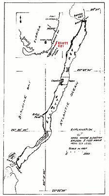
is just west of the southern end of Elliott Key. Elliott Key is about seven miles (11 km) long. Its maximum width is about 2500 feet (762 m) near the north end and its average width is less than 2000 feet (609.6 m). The higher elevations on the island range from 6 to 8 feet (2.4 m) above sea level and occur generally along an unimproved road that runs longitudinally through the center of the island. The average elevation is about 3 foot (0.9144 m) above sea level. The key is accessible only by boat. Elliot Key has a National Park Service
National Park Service
The National Park Service is the U.S. federal agency that manages all national parks, many national monuments, and other conservation and historical properties with various title designations...
campground, but is otherwise uninhabited.
History
Elliott Key was used on a transient basis for millennia by TequestaTequesta
The Tequesta Native American tribe, at the time of first European contact, occupied an area along the southeastern Atlantic coast of Florida...
Indians, and later by fishermen and wrecker
Wrecker
The Wrecker, wrecker or wrecking may refer to:* Wrecking is the practice of taking valuables from a shipwreck which has foundered near or close to shore* Wrecker is a Marvel Comics supervillain...
s from the Bahamas and the lower Florida Keys. The earlier name for the key was Ledbury Key, named after a snow
Snow (ship)
A snow or snaw is a sailing vessel. A type of brig , snows were primarily used as merchant ships, but saw war service as well...
that was driven ashore in 1769. There are legends of Elliott Key and adjacent keys being used as a refuge by pirates and escaped slave
Slavery
Slavery is a system under which people are treated as property to be bought and sold, and are forced to work. Slaves can be held against their will from the time of their capture, purchase or birth, and deprived of the right to leave, to refuse to work, or to demand compensation...
s. The chief pirate of legend is Black Caesar
Black Caesar (pirate)
Black Caesar was an 18th century African pirate. For nearly a decade, he raided shipping from the Florida Keys and later served as one of Captain Blackbeard's chief lieutenants aboard the Queen Anne's Revenge. He was one of the surviving members of Blackbeard's crew following his death at the...
, who is said to have escaped from a slave ship
Slave ship
Slave ships were large cargo ships specially converted for the purpose of transporting slaves, especially newly purchased African slaves to Americas....
, and used Elliott Key as his base. The key was inhabited and the site of pineapple
Pineapple
Pineapple is the common name for a tropical plant and its edible fruit, which is actually a multiple fruit consisting of coalesced berries. It was given the name pineapple due to its resemblance to a pine cone. The pineapple is by far the most economically important plant in the Bromeliaceae...
plantations in the latter part of the 19th Century and the first half of the 20th Century. In 1910 there were more than a dozen families raising pineapples on Elliott Key where an average crop was 50,000 to 75,000 dozen fruits, mostly sent by schooner
Schooner
A schooner is a type of sailing vessel characterized by the use of fore-and-aft sails on two or more masts with the forward mast being no taller than the rear masts....
to New York.
In the 1950s it was proposed to build a causeway (across the Safety Valve) and highway from Key Biscayne
Key Biscayne
Key Biscayne is an island located in Miami-Dade County, Florida, United States, between the Atlantic Ocean and Biscayne Bay. It is the southernmost of the barrier islands along the Atlantic coast of Florida, and lies south of Miami Beach and southeast of Miami...
to Key Largo, connecting Elliott Key and other keys to the mainland and the rest of the Florida Keys
Florida Keys
The Florida Keys are a coral archipelago in southeast United States. They begin at the southeastern tip of the Florida peninsula, about south of Miami, and extend in a gentle arc south-southwest and then westward to Key West, the westernmost of the inhabited islands, and on to the uninhabited Dry...
. This led to the incorporation of the city of Islandia, Florida
Islandia, Florida
Islandia is a city in Miami-Dade County, Florida, United States, located on Totten Key south of Elliott Key. The population was 18 at the 2010 Census...
, encompassing the keys north of Key Largo up to the Ragged Keys
Ragged Keys
Ragged Keys are small islands north of the upper Florida Keys.They are located in Biscayne Bay, just north of Sands Key.Earlier names for these islands were "Knox Island", "Laurence Island", "Los Paradisos", "Mascaras", "Mucaras", "Mucasas", "Pollock Island" and "Soldiers Island".Bernard Romans,...
. In anticipation of the highway, and to forestall designation of the northernmost keys as a park, developers cleared most of the land on Elliott Key and dredged channels around it. With the establishment of the Biscayne National Monument
Biscayne National Park
Biscayne National Park is a U.S. National Park located in southern Florida, due east of Homestead. The park preserves Biscayne Bay, one of the top scuba diving areas in the United States. Ninety-five percent of the park is water. In addition, the shore of the bay is the location of an extensive...
in 1968 and purchase of private property in the park by the Federal government, development of the highway and of Elliott Key was halted, and the money that was allocated for the proposed causeway was used to build a replacement Card Sound Bridge
Card Sound Bridge
Card Sound Bridge is a high-rise toll causeway connecting southern Miami-Dade County and northern Monroe County. It is one of only two ways that motorists can leave or enter the Florida Keys . Toll for two-axle automobiles is USD $1.00 , and SunPass is not accepted at this toll plaza...
connecting northern Key Largo
Key Largo
Key Largo is an island in the upper Florida Keys archipelago and, at long, the largest of the Keys. It is also the northernmost of the Florida Keys in Monroe County, and the northernmost of the Keys connected by U.S. Highway 1...
to the mainland.