

Somerset coalfield
Encyclopedia
The Somerset Coalfield included pits
Coal mining
The goal of coal mining is to obtain coal from the ground. Coal is valued for its energy content, and since the 1880s has been widely used to generate electricity. Steel and cement industries use coal as a fuel for extraction of iron from iron ore and for cement production. In the United States,...
in the North Somerset
Somerset
The ceremonial and non-metropolitan county of Somerset in South West England borders Bristol and Gloucestershire to the north, Wiltshire to the east, Dorset to the south-east, and Devon to the south-west. It is partly bounded to the north and west by the Bristol Channel and the estuary of the...
, England, area where coal
Coal
Coal is a combustible black or brownish-black sedimentary rock usually occurring in rock strata in layers or veins called coal beds or coal seams. The harder forms, such as anthracite coal, can be regarded as metamorphic rock because of later exposure to elevated temperature and pressure...
was mined from the 15th century until 1973.
It is part of a wider coalfield which covered northern Somerset and southern Gloucestershire
Gloucestershire
Gloucestershire is a county in South West England. The county comprises part of the Cotswold Hills, part of the flat fertile valley of the River Severn, and the entire Forest of Dean....
. It stretched from Cromhall
Cromhall
Cromhall is a village in South Gloucestershire, England. It lies between Bagstone and Charfield on the B4058. It also borders LeyhillCromhall is about 1 mile from Falfield on the A38 Tortworth turn off. Tortworth Estate is owned by Lord Morton, Earl of Ducie. The village of Cromhall is spread out...
in the north to the Mendip Hills
Mendip Hills
The Mendip Hills is a range of limestone hills to the south of Bristol and Bath in Somerset, England. Running east to west between Weston-super-Mare and Frome, the hills overlook the Somerset Levels to the south and the Avon Valley to the north...
in the south, and from Bath in the east to Nailsea
Nailsea
Nailsea is a town in the unitary authority of North Somerset within the ceremonial county of Somerset, England, approximately to the southwest of Bristol and about to the northeast of the seaside resort of Weston-super-Mare. The nearest village is Backwell, which lies south of Nailsea on the...
in the west, a total area of about 240 square miles (622 km²). Most of the pits in the Somerset Coalfield were concentrated along the Cam Brook, Wellow Brook and Nettlebridge Valleys and in the areas around Radstock
Radstock
Radstock is a town in Somerset, England, south west of Bath, and north west of Frome. It is within the unitary authority of Bath and North East Somerset and had a population of 5,275 according to the 2001 Census...
and Farrington Gurney
Farrington Gurney
Farrington Gurney is an English village and civil parish situated in Bath and North East Somerset unitary authority. The village lies on the junction of the A37 and the A362 in Somerset. The parish has a population of 846.-History:...
. The pits were often grouped geographically with clusters of pits which were close together working the same coal seams and often under the same ownership. Many also shared the same trackways and tramways which took the coal to the Somerset Coal Canal
Somerset Coal Canal
The Somerset Coal Canal was a narrow canal in England, built around 1800 from basins at Paulton and Timsbury via Camerton, an aqueduct at Dunkerton, Combe Hay, Midford and Monkton Combe to Limpley Stoke where it joined the Kennet and Avon Canal...
or railways for distribution.
Many of the early pits were bell pit
Bell pit
A bell pit is a primitive method of mining coal, iron ore or other minerals where the coal or ore lies near the surface.. A shaft is sunk to reach the mineral which is excavated by miners transported to the surface by a winch and removed by means of a bucket, much like a well. It gets its name...
s; however, these were replaced as deeper seams were mined, with the deepest shaft being the Strap mine at Nettlebridge, which reached 1838 feet (560 m). Flooding in some of the mines and coal dust explosions required improved ventilation and equipment. Several pits closed in the 19th century as the available coal was worked out. Those that survived until 1947 became part of the National Coal Board
National Coal Board
The National Coal Board was the statutory corporation created to run the nationalised coal mining industry in the United Kingdom. Set up under the Coal Industry Nationalisation Act 1946, it took over the mines on "vesting day", 1 January 1947...
, but the expense of improving equipment and working conditions meant that even these became uneconomic and the last pit closed in 1973. There is still evidence of the mine workings with the remains of buildings, spoil heaps and tramways around the area.
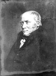
Early surveys of William Smith
William Smith (geologist)
William 'Strata' Smith was an English geologist, credited with creating the first nationwide geological map. He is known as the "Father of English Geology" for collating the geological history of England and Wales into a single record, although recognition was very slow in coming...
, who became known as the "Father of English Geology
Geology
Geology is the science comprising the study of solid Earth, the rocks of which it is composed, and the processes by which it evolves. Geology gives insight into the history of the Earth, as it provides the primary evidence for plate tectonics, the evolutionary history of life, and past climates...
", building on work in the same area by John Strachey
John Strachey (geologist)
John Strachey was a British geologist.He was born in Chew Magna, England, a member of the Strachey Baronets. He inherited estates including Sutton Court from his father at three years of age. He matriculated at Trinity College, Oxford and was admitted at Middle Temple, London, in 1688...
. Smith worked at one of the estate's older mines, the Mearns Pit at High Littleton
High Littleton
The village of High Littleton and its hamlets of Hallatrow and Amesbury form a civil parish and are located in the county of Somerset and straddle both the A39 and A37, from Bath, from Wells and from Bristol. The parish has a population of 2,086...
. As he observed the rock strata
Stratum
In geology and related fields, a stratum is a layer of sedimentary rock or soil with internally consistent characteristics that distinguish it from other layers...
, at the pit he realised that they were arranged in a predictable pattern, and that the various strata could always be found in the same relative positions. Additionally, each particular stratum could be identified by the fossil
Fossil
Fossils are the preserved remains or traces of animals , plants, and other organisms from the remote past...
s it contained, and the same succession of fossil groups from older to younger rocks could be found in other parts of England. Furthermore, he noticed an easterly dip of the beds of rock- small near the surface (about three degree
Degree (angle)
A degree , usually denoted by ° , is a measurement of plane angle, representing 1⁄360 of a full rotation; one degree is equivalent to π/180 radians...
s) then bigger after the Triassic
Triassic
The Triassic is a geologic period and system that extends from about 250 to 200 Mya . As the first period of the Mesozoic Era, the Triassic follows the Permian and is followed by the Jurassic. Both the start and end of the Triassic are marked by major extinction events...
rocks. This gave Smith a testable hypothesis
Hypothesis
A hypothesis is a proposed explanation for a phenomenon. The term derives from the Greek, ὑποτιθέναι – hypotithenai meaning "to put under" or "to suppose". For a hypothesis to be put forward as a scientific hypothesis, the scientific method requires that one can test it...
, which he termed The Principle of Faunal Succession, and he began his search to determine if the relationships between the strata and their characteristics were consistent throughout the country. During subsequent travels, first as a surveyor (appointed by noted engineer
Engineer
An engineer is a professional practitioner of engineering, concerned with applying scientific knowledge, mathematics and ingenuity to develop solutions for technical problems. Engineers design materials, structures, machines and systems while considering the limitations imposed by practicality,...
John Rennie) for the canal company until 1799 when he was dismissed, and later, he was continually taking samples and mapping the locations of the various strata, and displaying the vertical extent of the strata, and drawing cross-sections and tables of what he saw. This would earn him the name "Strata Smith".
Structure of the coalfield
The Somerset Coalfield consists of three synclineSyncline
In structural geology, a syncline is a fold, with younger layers closer to the center of the structure. A synclinorium is a large syncline with superimposed smaller folds. Synclines are typically a downward fold, termed a synformal syncline In structural geology, a syncline is a fold, with younger...
s, informally referred to as 'coal basins'. The Pensford
Pensford
Pensford is a village in the civil parish of Publow and Pensford in Somerset, England. It lies in the Chew Valley south of Bristol and west of Bath...
Syncline in the north and the Radstock
Radstock
Radstock is a town in Somerset, England, south west of Bath, and north west of Frome. It is within the unitary authority of Bath and North East Somerset and had a population of 5,275 according to the 2001 Census...
Syncline in the south are separated by the east-west trending Farmborough
Farmborough
Farmborough is a small village and civil parish, south west of Bath in Somerset, England. The parish has a population of 1,103.- History :The parish of Farmborough was part of the Keynsham Hundred,...
Fault Belt. Further to the west is the smaller Nailsea
Nailsea
Nailsea is a town in the unitary authority of North Somerset within the ceremonial county of Somerset, England, approximately to the southwest of Bristol and about to the northeast of the seaside resort of Weston-super-Mare. The nearest village is Backwell, which lies south of Nailsea on the...
Syncline. The Radstock Syncline in particular is cut by a series of east-west thrust fault
Thrust fault
A thrust fault is a type of fault, or break in the Earth's crust across which there has been relative movement, in which rocks of lower stratigraphic position are pushed up and over higher strata. They are often recognized because they place older rocks above younger...
s and north-south trending normal faults.
Stratigraphy
The Coal Measures of the Somerset Coalfield are divided into a Lower, Middle and Upper with coal seams found within each of these divisions. Lower and Middle Coal Measures are found at depths between 500 and 5,000 feet (152-1,525 m). Together the Lower and Middle Coal Measures are 2,000 to 2,500 feet (610–762 m) thick with the Middle Coal Measures averaging about 1,600 feet (488 m) and the Lower Coal Measures about 600 feet (183 m).Only in the southern part of the Radstock Syncline have coals of the Lower and Middle Coal Measures been worked, mainly at the Newbury and Vobster collieries in the southeast and in the New Rock and Moorewood pits to the southwest. Only in the eastern part of Pensford Syncline have coals of the Lower and Middle Coal Measures been worked, at the Globe Pit in the Newton St Loe area in the 19th century. The Variscan orogeny
Variscan orogeny
The Variscan orogeny is a geologic mountain-building event caused by Late Paleozoic continental collision between Euramerica and Gondwana to form the supercontinent of Pangaea.-Naming:...
involved lateral compression of the rock sequence resulting in the tight folding, fracturing and faulting of the sandstone
Sandstone
Sandstone is a sedimentary rock composed mainly of sand-sized minerals or rock grains.Most sandstone is composed of quartz and/or feldspar because these are the most common minerals in the Earth's crust. Like sand, sandstone may be any colour, but the most common colours are tan, brown, yellow,...
and mudstone
Mudstone
Mudstone is a fine grained sedimentary rock whose original constituents were clays or muds. Grain size is up to 0.0625 mm with individual grains too small to be distinguished without a microscope. With increased pressure over time the platey clay minerals may become aligned, with the...
strata, and the associated coal seams, of the Coal Measures. Along the Radstock Slide Fault the distance between the broken ends of a coal seam can be as much as 1500 feet (457 m). The complex geology and narrow seams gained the field notoriety and three underground explosions, in 1893, 1895 and 1908 were amongst the first attributable solely to airborne coal dust.
Coal seams
The following coal seams are recognised within the coalfield. They are listed stratigraphically ie uppermost/youngest at the top. Note that not all seams are continuous across the entire coalfield and that correlation of certain seams from one basin to another is uncertain.The Upper Coal Measures are within Pennant Sandstones and include:
The Middle Coal Measures include:
The Lower Coal Measures include:
The Peacock and Brights Coals are also recorded within the Upper Coal Measures between the Rudge and New Coals.
History
It is believed that coal was minedMining in Roman Britain
Mining was one of the most prosperous activities in Roman Britain. Britain was rich in resources such as copper, gold, iron, lead, salt, silver, and tin, materials in high demand in the Roman Empire. The abundance of mineral resources in the British Isles was probably one of the reasons for the...
in the area during Roman
Roman Britain
Roman Britain was the part of the island of Great Britain controlled by the Roman Empire from AD 43 until ca. AD 410.The Romans referred to the imperial province as Britannia, which eventually comprised all of the island of Great Britain south of the fluid frontier with Caledonia...
times and there is documentary evidence of coal being dug on the Mendips in 1305 and at Kilmersdon
Kilmersdon
Kilmersdon is a small village located in the north of Somerset between the towns of Radstock and Frome. The settlement is recorded in William I's Domesday book and dates back at least 1,000 years; though the core of the village dates from the mid nineteenth century.-History:The name Kilmersdon...
in 1437. By the time of Henry VIII
Henry VIII of England
Henry VIII was King of England from 21 April 1509 until his death. He was Lord, and later King, of Ireland, as well as continuing the nominal claim by the English monarchs to the Kingdom of France...
there were coal pits at Clutton
Clutton, Somerset
Clutton is a village and civil parish within the Chew Valley in Somerset in the Bath and North East Somerset Council area on the A37 road. It is located 10 miles from Bristol and Bath, very near Temple Cloud. The nearest town is Midsomer Norton...
, High Littleton
High Littleton
The village of High Littleton and its hamlets of Hallatrow and Amesbury form a civil parish and are located in the county of Somerset and straddle both the A39 and A37, from Bath, from Wells and from Bristol. The parish has a population of 2,086...
and Stratton-on-the-Fosse
Stratton-on-the-Fosse
Stratton-on-the-Fosse is a village and civil parish located on the edge of the Mendip Hills, south-west of Westfield, north-east of Shepton Mallet, and from Frome, in Somerset, England. It has a population 1,045, and has a rural agricultural landscape, although it was part of the once-thriving...
.
During the early part of the 17th century coal was largely obtained by excavating the outcrops or driving an incline
Inclined plane
The inclined plane is one of the original six simple machines; as the name suggests, it is a flat surface whose endpoints are at different heights. By moving an object up an inclined plane rather than completely vertical, the amount of force required is reduced, at the expense of increasing the...
, which involved following the seam into the ground. Only a small amount of coal could be obtained by these methods and so bell pit
Bell pit
A bell pit is a primitive method of mining coal, iron ore or other minerals where the coal or ore lies near the surface.. A shaft is sunk to reach the mineral which is excavated by miners transported to the surface by a winch and removed by means of a bucket, much like a well. It gets its name...
s took their place. These were vertical pits, about 4 feet (1.2 m) in diameter at the top and as much as 60 feet (18.3 m) deep, which were widened out at the bottom. When all the coal that could safely be extracted from a bell pit had been recovered, another pit would be sunk close by to intersect the seam and the waste from the second pit thrown into the first pit.
At the beginning of the 19th century there were about 4000 people employed in the coalfield. The industrial uses of coal were varied. Coal was used in limekilns
Limekilns
Limekilns, a village in Fife, Scotland, lies on the shore of the Firth of Forth.Unlike the neighbouring village of Charlestown, Limekilns is an extremely old settlement dating back to the 14th century. The oldest building in the village is without doubt The King's Cellar, a large and somewhat...
to produce lime
Calcium oxide
Calcium oxide , commonly known as quicklime or burnt lime, is a widely used chemical compound. It is a white, caustic, alkaline crystalline solid at room temperature....
, which was much in demand for mortar
Mortar (masonry)
Mortar is a workable paste used to bind construction blocks together and fill the gaps between them. The blocks may be stone, brick, cinder blocks, etc. Mortar becomes hard when it sets, resulting in a rigid aggregate structure. Modern mortars are typically made from a mixture of sand, a binder...
production for building purposes and by farmers to improve soil. From 1820 it was used to produce gas
Coal gas
Coal gas is a flammable gaseous fuel made by the destructive distillation of coal containing a variety of calorific gases including hydrogen, carbon monoxide, methane and volatile hydrocarbons together with small quantities of non-calorific gases such as carbon dioxide and nitrogen...
for town lighting and to drive the woollen mills in the area. Coke
Coke (fuel)
Coke is the solid carbonaceous material derived from destructive distillation of low-ash, low-sulfur bituminous coal. Cokes from coal are grey, hard, and porous. While coke can be formed naturally, the commonly used form is man-made.- History :...
uses included drying malt
Malt
Malt is germinated cereal grains that have been dried in a process known as "malting". The grains are made to germinate by soaking in water, and are then halted from germinating further by drying with hot air...
in the brewing
Brewing
Brewing is the production of beer through steeping a starch source in water and then fermenting with yeast. Brewing has taken place since around the 6th millennium BCE, and archeological evidence suggests that this technique was used in ancient Egypt...
industry.
Transport
The Somerset Coalfield did not have the benefit of a major coal-consuming industry, and had a relatively low density of population nearby. Therefore, transport to market was a key problem for the coalfield's development.Being in an agricultural area, during the pre-turnpike
Turnpike trust
Turnpike trusts in the United Kingdom were bodies set up by individual Acts of Parliament, with powers to collect road tolls for maintaining the principal highways in Britain from the 17th but especially during the 18th and 19th centuries...
era, the roads serving the coalfield were initially unsuited to moving coal. Bulley notes "The problem ... was rendered far worse by the state of the roads in Somerset, which were notorious down to the middle of the 18th century. Parishes in the area sometimes neglected or refused to repair those roads which were heavily used by coal carts. Thus in 1617 the inhabitants of Stoke St Michael ... complained that "of late by reason of many coalmines ... the highways there are much in decay and grown very founderous".
For Somerset, the turnpike phase began in 1707 with the establishment of the Bath Trust, but it was not until the middle of that century that other trusts serving the coalfield were formed. The Bristol Trust, part of which passed close to the western boundary of the coalfield, was established in 1727, but it was of little importance, as Bristol was never a significant market, having its own coalfields on the Bristol Coalfield
Bristol Coalfield
The Bristol Coalfield is a geologically complex coalfield in the west of England. Comprising the coal-bearing rocks arranged around the Coalpit Heath Syncline and Kingsdown Anticline, it extends beneath the eastern parts of the city of Bristol and northwards through southern Gloucestershire...
at Kingswood Chase and Coalpit Heath
Coalpit Heath
Coalpit Heath is a small village in the parish of Westerleigh, South Gloucestershire, England, south of Yate and east of Frampton Cotterell in South Gloucestershire.-Background:...
, and easy import of coal from South Wales
South Wales
South Wales is an area of Wales bordered by England and the Bristol Channel to the east and south, and Mid Wales and West Wales to the north and west. The most densely populated region in the south-west of the United Kingdom, it is home to around 2.1 million people and includes the capital city of...
. Turnpikes facilitated the movement of coal, and John Billingsley
John Billingsley
John Billingsley is an American actor, known for his role as Doctor Phlox on the television series Star Trek: Enterprise.-Career:...
enthused "Nothing so much contributes to the improvement of a county as good roads. Before the establishment of turnpikes, many parts of the county were scarcely accessible. .... coal was carried on horses' backs to the distance of fifteen or twenty miles from the colliery; each horse carried about two hundred and half weight. Now one horse with a light cart will draw four hundred weight or four times more than a horse could carry. Can an insignificant toll be put in competition with this saving?."
Not all roads were turnpikes, and as late as 1819 Skinner observed roads "rendered bad" by the passage of coal wagons. The growth of the coalfield was limited by access to market. Such a need implied a canal project, following Lord Middleton's dictum "Water transport is what all coal owners must aim at". There were large gains from being connected to a canal system, as stated by the Coal Commission "At about this period (1800) the system of coal navigation was being rapidly extended, and the result was that coals were gradually finding their way into districts that could not be reached unless at great cost, by road".
In Somerset, the earliest scheme proposed an extension of the Avon Navigation in 1766, but the canal era was not to reach the coalfield for almost another fifty years. In 1794 coal proprietors formed a committee to arrange the construction of the Somerset Coal Canal
Somerset Coal Canal
The Somerset Coal Canal was a narrow canal in England, built around 1800 from basins at Paulton and Timsbury via Camerton, an aqueduct at Dunkerton, Combe Hay, Midford and Monkton Combe to Limpley Stoke where it joined the Kennet and Avon Canal...
. It was to have two branches extending into the Cam Brook and Wellow Brook Valleys, and from the junction at Midford
Midford
Midford is a village approximately miles south south east of Bath, Somerset, England within the Cotswold Area of Outstanding Natural Beauty...
, to join the then proposed Kennet and Avon Canal
Kennet and Avon Canal
The Kennet and Avon Canal is a waterway in southern England with an overall length of , made up of two lengths of navigable river linked by a canal. The name is commonly used to refer to the entire length of the navigation rather than solely to the central canal section...
at the Dundas Aqueduct
Dundas Aqueduct
Dundas Aqueduct carries the Kennet and Avon Canal over the River Avon and the Wessex Main Line railway from Bath to Westbury, near Limpley Stoke in Wiltshire, England....
near Bath. Somerset was fortunate in that the coalfield was the sole supplier to this canal network and was therefore able to pass the high extraction costs directly onto the customer. Having monopolistic powers, the Somerset Coal Canal Company was often guilty of unaccommodating behaviour to its customers and failing to pass on drawbacks offered by the Kennet and Avon Canal. After 1854, when the first railway line to the coalfield was opened, the tonnage carried by the coal canal declined very rapidly. The coal was transported by the Somerset Coal Canal
Somerset Coal Canal
The Somerset Coal Canal was a narrow canal in England, built around 1800 from basins at Paulton and Timsbury via Camerton, an aqueduct at Dunkerton, Combe Hay, Midford and Monkton Combe to Limpley Stoke where it joined the Kennet and Avon Canal...
and later by the Bristol and North Somerset Railway
Bristol and North Somerset Railway
The Bristol and North Somerset Railway was a railway line in the West of England that connected Bristol with towns in the Somerset coalfield. The line ran almost due south from Bristol and was 16 miles long.-The main railway:...
and Somerset and Dorset Joint Railway
Somerset and Dorset Joint Railway
The Somerset & Dorset Joint Railway – almost always referred to as "the S&D" – was an English railway line connecting Bath in north east Somerset and Bournemouth now in south east Dorset but then in Hampshire...
, which were reached from the pits by a series of tramways.
Tonnage increased throughout the 19th century, reaching a peak around 1901, when there were 79 separate collieries and annual production was 1,250,000 tons per annum.
Decline and closure
The peak years were 1900 to 1920. However the decline soon took hold and the number of pits reduced from 30 at the beginning of the 20th century to 14 by the mid-thirties, 12 at nationalisation to create the National Coal BoardNational Coal Board
The National Coal Board was the statutory corporation created to run the nationalised coal mining industry in the United Kingdom. Set up under the Coal Industry Nationalisation Act 1946, it took over the mines on "vesting day", 1 January 1947...
on 1 January 1947, 5 by 1959 and none after 1973. Despite some investment in new infrastructure, particularly at Norton Hill, narrow seams made production expensive, limiting profit and investment. The conversion of Portishead power station
Portishead power station
Portishead Power Station refers to a series of two coal and oil-fired power stations. They were built in the dock area of Portishead in Somerset, South West England....
from coal to oil and reduced national demand together with competition from more economical coalfields led to the closure of the last two pits in the coalfield, Kilmersdon and Writhlington, in September 1973.
Area today
Although there are still the remains of the mines, in the form of disused or redeveloped buildings and a few spoil tips, most of which have been removed or landscaped, the area has returned to a largely rural nature between the Mendip HillsMendip Hills
The Mendip Hills is a range of limestone hills to the south of Bristol and Bath in Somerset, England. Running east to west between Weston-super-Mare and Frome, the hills overlook the Somerset Levels to the south and the Avon Valley to the north...
and the River Avon
River Avon, Bristol
The River Avon is an English river in the south west of the country. To distinguish it from a number of other River Avons in Britain, this river is often also known as the Lower Avon or Bristol Avon...
in north east Somerset. The towns and villages have light industry
Light industry
Light industry is usually less capital intensive than heavy industry, and is more consumer-oriented than business-oriented...
but are often commuter town
Commuter town
A commuter town is an urban community that is primarily residential, from which most of the workforce commutes out to earn their livelihood. Many commuter towns act as suburbs of a nearby metropolis that workers travel to daily, and many suburbs are commuter towns...
s for Bath and Bristol
Bristol
Bristol is a city, unitary authority area and ceremonial county in South West England, with an estimated population of 433,100 for the unitary authority in 2009, and a surrounding Larger Urban Zone with an estimated 1,070,000 residents in 2007...
. There is still quarrying of limestone
Limestone
Limestone is a sedimentary rock composed largely of the minerals calcite and aragonite, which are different crystal forms of calcium carbonate . Many limestones are composed from skeletal fragments of marine organisms such as coral or foraminifera....
, particularly in the Mendips.
The Colliers Way (NCR24) is a national cycle route which passes landmarks associated with the coalfield, and other local roads and footpaths follow the tramways developed during the coal mining years. It currently runs from Dundas Aqueduct
Dundas Aqueduct
Dundas Aqueduct carries the Kennet and Avon Canal over the River Avon and the Wessex Main Line railway from Bath to Westbury, near Limpley Stoke in Wiltshire, England....
to Frome
Frome
Frome is a town and civil parish in northeast Somerset, England. Located at the eastern end of the Mendip Hills, the town is built on uneven high ground, and centres around the River Frome. The town is approximately south of Bath, east of the county town, Taunton and west of London. In the 2001...
via Radstock
Radstock
Radstock is a town in Somerset, England, south west of Bath, and north west of Frome. It is within the unitary authority of Bath and North East Somerset and had a population of 5,275 according to the 2001 Census...
, although it is intended to provide a continuous cycle route to Southampton
Southampton
Southampton is the largest city in the county of Hampshire on the south coast of England, and is situated south-west of London and north-west of Portsmouth. Southampton is a major port and the closest city to the New Forest...
and Portsmouth
Portsmouth
Portsmouth is the second largest city in the ceremonial county of Hampshire on the south coast of England. Portsmouth is notable for being the United Kingdom's only island city; it is located mainly on Portsea Island...
.
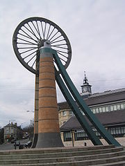
Radstock Museum
Radstock Museum
Radstock museum in Radstock, Somerset has a range of exhibits which offer an insight into North Somerset life since the nineteenth century.The museum was originally opened in 1989 in barns in Haydon, and moved to its current site in the restored and converted Victorian Market Hall, a grade II...
has a range of exhibits which offer an insight into North Somerset
Somerset
The ceremonial and non-metropolitan county of Somerset in South West England borders Bristol and Gloucestershire to the north, Wiltshire to the east, Dorset to the south-east, and Devon to the south-west. It is partly bounded to the north and west by the Bristol Channel and the estuary of the...
life since the 19th century. Exhibits relate to the Somerset Coalfield and its geology
Geology
Geology is the science comprising the study of solid Earth, the rocks of which it is composed, and the processes by which it evolves. Geology gives insight into the history of the Earth, as it provides the primary evidence for plate tectonics, the evolutionary history of life, and past climates...
. Artefacts and memorabilia of the Somerset Coal Canal
Somerset Coal Canal
The Somerset Coal Canal was a narrow canal in England, built around 1800 from basins at Paulton and Timsbury via Camerton, an aqueduct at Dunkerton, Combe Hay, Midford and Monkton Combe to Limpley Stoke where it joined the Kennet and Avon Canal...
, Somerset and Dorset
Somerset and Dorset Joint Railway
The Somerset & Dorset Joint Railway – almost always referred to as "the S&D" – was an English railway line connecting Bath in north east Somerset and Bournemouth now in south east Dorset but then in Hampshire...
and Great Western Railway
Great Western Railway
The Great Western Railway was a British railway company that linked London with the south-west and west of England and most of Wales. It was founded in 1833, received its enabling Act of Parliament in 1835 and ran its first trains in 1838...
s are also on display.
Pensford coal basin
The PensfordPensford
Pensford is a village in the civil parish of Publow and Pensford in Somerset, England. It lies in the Chew Valley south of Bristol and west of Bath...
coal basin lies in the northern area of the Somerset coal field around Bishop Sutton
Bishop Sutton
Bishop Sutton is a small village within the Chew Valley in Somerset. It lies south of Chew Valley Lake and north of the Mendip Hills, approximately ten miles south of Bristol on the A368, Weston-super-Mare to Bath road...
, Pensford, Stanton Drew
Stanton Drew
Stanton Drew is a small village and civil parish within the Chew Valley in Somerset, England, situated north of the Mendip Hills, south of Bristol in the Bath and North East Somerset Unitary Authority....
, Farmborough
Farmborough
Farmborough is a small village and civil parish, south west of Bath in Somerset, England. The parish has a population of 1,103.- History :The parish of Farmborough was part of the Keynsham Hundred,...
and Hunstrete
Hunstrete
Hunstrete is a small village on the River Chew in the Chew Valley, Bath and North East Somerset, England. It falls within the civil parish of Marksbury and is 8 miles from Bristol, and Bath, and 5 miles from Keynsham.- History :...
.
The date for the first pits around Bishop Sutton are uncertain but there was at least one before 1719. By 1824 a collection of four bell pit
Bell pit
A bell pit is a primitive method of mining coal, iron ore or other minerals where the coal or ore lies near the surface.. A shaft is sunk to reach the mineral which is excavated by miners transported to the surface by a winch and removed by means of a bucket, much like a well. It gets its name...
s were identified in field tithe No 1409, and four shaft pits in field tithe No 1428, but that they were no longer working.
The Old Pit at Bishop Sutton, which was also known as Sutton Top Pit or Upper Sutton Pit was dug before 1799 and owned by Lieutenant Henry Fisher, who sold it in 1821 to Robert Blinman Dowling and seams of coal were identified and exploited. After Dowling's death the Old Pit was sold to Mr T.T. Hawkes in 1852, but he defaulted on the payments and it was sold in 1853 to William Rees-Mogg (an ancestor of William Rees-Mogg
William Rees-Mogg
William Rees-Mogg, Baron Rees-Mogg is an English journalist and life peer.-Education:Rees-Mogg was educated at Clifton College Preparatory School in Bristol and Charterhouse School in Godalming, followed by Balliol College, Oxford...
) and his associates. The shaft reached a depth of 304 feet (93 m), but went out of production by 1855, when the "New" Pit which had been sunk in the early 19th century but then closed, was reopened and deepened to exploit deeper seams. The New Pit had two shafts of 4 feet (1.2 m) diameter, one for winding and one for pumping. In 1896 it was owned by F. Spencer, New Rock Colliery, and in 1908 owned by Jesse Lovell and Sons The pit finally closed in 1929.
The Pesnford Colliery which opened in 1909 had the latest equipment at the time including coal cutters underground and red brick winding house, baths and coal washers. Underground faulting made coal production expensive and the pit closed in 1958.
| Colliery | Location | Coordinates | Opened | Closed | Shaft diameter (ft in (m)) | Max shaft depth (ft (m)) | Notes |
|---|---|---|---|---|---|---|---|
| Bishop Sutton (old) | Bishop Sutton Bishop Sutton Bishop Sutton is a small village within the Chew Valley in Somerset. It lies south of Chew Valley Lake and north of the Mendip Hills, approximately ten miles south of Bristol on the A368, Weston-super-Mare to Bath road... |
51.3353°N 2.5935°W | c1811 | 1855 | ? | 304 (92.7) | Bought by William Rees-Mogg in 1835 |
| Bishop Sutton (new) | Bishop Sutton Bishop Sutton Bishop Sutton is a small village within the Chew Valley in Somerset. It lies south of Chew Valley Lake and north of the Mendip Hills, approximately ten miles south of Bristol on the A368, Weston-super-Mare to Bath road... |
51.3353°N 2.5935°W | 1855 | 1929 | 9 0 (2.7) | 877 (267.3) | 1896 owned by F. Spencer, New Rock Colliery, 1908 owned by J Lovell and Sons |
| Bromley | Pensford Pensford Pensford is a village in the civil parish of Publow and Pensford in Somerset, England. It lies in the Chew Valley south of Bristol and west of Bath... |
51.3715°N 2.5480°W | 1860 | 1957 | 4 6 (1.4) | 475 (144.8) | 1896 & 1908 Owned by Bromley Coal Co Ltd. |
| Common Wood Level | Hunstrete Hunstrete Hunstrete is a small village on the River Chew in the Chew Valley, Bath and North East Somerset, England. It falls within the civil parish of Marksbury and is 8 miles from Bristol, and Bath, and 5 miles from Keynsham.- History :... |
51.3600°N 2.5077°W | 1829 | 1832 | ? | ? | No coal mined. Attempts made again in 1969 but unsuccessful |
| Farmborough | Farmborough | 51.3430°N 2.4845°W | c1841 | 1847 | ? | 1413 (430.7) | No coal mined |
| Pensford | Pensford Pensford Pensford is a village in the civil parish of Publow and Pensford in Somerset, England. It lies in the Chew Valley south of Bristol and west of Bath... |
51.3625°N 2.5479°W | 1909 | 1955 | 14 0 (4.3) | 1494 (445.4) | |
| Rydon's (or Riding's) | Stanton Drew Stanton Drew Stanton Drew is a small village and civil parish within the Chew Valley in Somerset, England, situated north of the Mendip Hills, south of Bristol in the Bath and North East Somerset Unitary Authority.... |
51.3669°N 2.5796°W | 1808 | 1833 | ? | 312 (95) |
Earl of Warwick's Clutton Collieries
Coal minesCoal mining
The goal of coal mining is to obtain coal from the ground. Coal is valued for its energy content, and since the 1880s has been widely used to generate electricity. Steel and cement industries use coal as a fuel for extraction of iron from iron ore and for cement production. In the United States,...
were established in the villages of High Littleton
High Littleton
The village of High Littleton and its hamlets of Hallatrow and Amesbury form a civil parish and are located in the county of Somerset and straddle both the A39 and A37, from Bath, from Wells and from Bristol. The parish has a population of 2,086...
and Hallatrow by 1633 because here the coal seams ran obliquely to the surface. The first deep mine was Mearns Coalworks which began in 1783. The Greyfield Coal Company did not start until 1833.
The Earl of Warwick
Earl of Warwick
Earl of Warwick is a title that has been created four times in British history and is one of the most prestigious titles in the peerages of the British Isles.-1088 creation:...
's estates included sawmill
Sawmill
A sawmill is a facility where logs are cut into boards.-Sawmill process:A sawmill's basic operation is much like those of hundreds of years ago; a log enters on one end and dimensional lumber exits on the other end....
s, quarries
Quarry
A quarry is a type of open-pit mine from which rock or minerals are extracted. Quarries are generally used for extracting building materials, such as dimension stone, construction aggregate, riprap, sand, and gravel. They are often collocated with concrete and asphalt plants due to the requirement...
, brickworks
Brickworks
A brickworks also known as a brick factory, is a factory for the manufacturing of bricks, from clay or shale. Usually a brickworks is located on a clay bedrock often with a quarry for clay on site....
and collieries in addition to their agricultural holdings. These pits, around Clutton
Clutton, Somerset
Clutton is a village and civil parish within the Chew Valley in Somerset in the Bath and North East Somerset Council area on the A37 road. It is located 10 miles from Bristol and Bath, very near Temple Cloud. The nearest town is Midsomer Norton...
and High Littleton
High Littleton
The village of High Littleton and its hamlets of Hallatrow and Amesbury form a civil parish and are located in the county of Somerset and straddle both the A39 and A37, from Bath, from Wells and from Bristol. The parish has a population of 2,086...
, were first described in a survey of 1610. All were closed by 1836.
| Colliery | Location | Coordinates | Opened | Closed | Shaft diameter (ft in (m)) | Max shaft depth (ft (m)) | Notes |
|---|---|---|---|---|---|---|---|
| Burchells (sometimes spelt Burchills or Birchill's) | Clutton Clutton, Somerset Clutton is a village and civil parish within the Chew Valley in Somerset in the Bath and North East Somerset Council area on the A37 road. It is located 10 miles from Bristol and Bath, very near Temple Cloud. The nearest town is Midsomer Norton... |
51.3320°N 2.5389°W | 1911 (reopened) | 1921 | ? | 148 (45.1) | |
| Fry's Bottom | Clutton Clutton, Somerset Clutton is a village and civil parish within the Chew Valley in Somerset in the Bath and North East Somerset Council area on the A37 road. It is located 10 miles from Bristol and Bath, very near Temple Cloud. The nearest town is Midsomer Norton... |
51.3410°N 2.5376°W | 1830s | 1885 | 9 0 (2.7) | 588 (179.2) | |
| Greyfield | Clutton Clutton, Somerset Clutton is a village and civil parish within the Chew Valley in Somerset in the Bath and North East Somerset Council area on the A37 road. It is located 10 miles from Bristol and Bath, very near Temple Cloud. The nearest town is Midsomer Norton... |
51.3249°N 2.5159°W | 1833 | 1911 | 10 0 (3) | 900 (274.3) | 1908 Owned by Greyfield Colliery Co. Ltd., |
| Mooresland | Clutton Clutton, Somerset Clutton is a village and civil parish within the Chew Valley in Somerset in the Bath and North East Somerset Council area on the A37 road. It is located 10 miles from Bristol and Bath, very near Temple Cloud. The nearest town is Midsomer Norton... |
51.3249°N 2.5159°W | 1840s | ? | ? | ? | Output transferred to nearby Greyfield |
Paulton Basin
Paulton
Paulton is a large village and civil parish, with a population of 4,896, located to the north of the Mendip Hills, in the unitary authority of Bath and North East Somerset , England....
was the terminus of the northern branch of the Somerset Coal Canal
Somerset Coal Canal
The Somerset Coal Canal was a narrow canal in England, built around 1800 from basins at Paulton and Timsbury via Camerton, an aqueduct at Dunkerton, Combe Hay, Midford and Monkton Combe to Limpley Stoke where it joined the Kennet and Avon Canal...
and was a central point for at least 15 collieries around Paulton, Timsbury
Timsbury, Somerset
Timsbury is a village and civil parish in the Bath and North East Somerset unitary authority of the county of Somerset, south-west of Bath England...
and High Littleton
High Littleton
The village of High Littleton and its hamlets of Hallatrow and Amesbury form a civil parish and are located in the county of Somerset and straddle both the A39 and A37, from Bath, from Wells and from Bristol. The parish has a population of 2,086...
, which were connected to the canal by tramroads.
On the northern side of Paulton basin was the terminus for the tramroad which served Old Grove, Prior's, Tyning and Hayeswood pits, with a branch line to Amesbury and Mearns pits. Parts of this line were still in use in 1873, probably all carrying horse drawn wagons of coal.
The southern side of the basin served Brittens, Littleborrok, Paulton Ham, Paulton Hill, Simons Hill terminating at Salisbury Colliery. In addition the Paulton Foundry used this line. The entire line was disused by 1871 as were the collieries it served.
The area has been designated as an ‘area of special architectural or historic interest, the character or appearance of which it
is desirable to preserve or enhance’ under section 69 of the Planning (Listed Buildings and Conservation Areas) Act 1990
Planning (Listed Buildings and Conservation Areas) Act 1990
The Planning Act 1990 is an Act of Parliament of the United Kingdom that altered the laws on granting of planning permission for building works, notably including those of the listed building system in England and Wales....
.
| Colliery | Location | Coordinates | Opened | Closed | Shaft diameter (ft in (m)) | Max shaft depth (ft (m)) | Notes |
|---|---|---|---|---|---|---|---|
| Amesbury | High Littleton High Littleton The village of High Littleton and its hamlets of Hallatrow and Amesbury form a civil parish and are located in the county of Somerset and straddle both the A39 and A37, from Bath, from Wells and from Bristol. The parish has a population of 2,086... |
51.3277°N 2.4944°W | before 1701 | early 19th century | ? | 200 (61) | |
| Brewers | Paulton Paulton Paulton is a large village and civil parish, with a population of 4,896, located to the north of the Mendip Hills, in the unitary authority of Bath and North East Somerset , England.... |
51.3079°N 2.5028°W | before 1700 | ? | ? | 102 (31) | |
| Brittens Lower | Paulton Paulton Paulton is a large village and civil parish, with a population of 4,896, located to the north of the Mendip Hills, in the unitary authority of Bath and North East Somerset , England.... |
51.3061°N 2.4927°W | ? | by 1864 | ? | ? | |
| Brittens New | Paulton Paulton Paulton is a large village and civil parish, with a population of 4,896, located to the north of the Mendip Hills, in the unitary authority of Bath and North East Somerset , England.... |
51.3061°N 2.4927°W | ? | by 1864 | ? | ? | |
| Brombel (or Brombells, possibly Allens Paddock) | Paulton Paulton Paulton is a large village and civil parish, with a population of 4,896, located to the north of the Mendip Hills, in the unitary authority of Bath and North East Somerset , England.... |
51.3079°N 2.5028°W | before 1793 | ? | 4 6 (1.4) | ? | |
| Crossways | Paulton Paulton Paulton is a large village and civil parish, with a population of 4,896, located to the north of the Mendip Hills, in the unitary authority of Bath and North East Somerset , England.... |
51.3079°N 2.5028°W | ? | ? | 5 (1.5) | 144 (43.9) | |
| Goosard (or Gooseward or Goosewardsham or Paulton Lower Engine) | Paulton Paulton Paulton is a large village and civil parish, with a population of 4,896, located to the north of the Mendip Hills, in the unitary authority of Bath and North East Somerset , England.... |
51.3160°N 2.4957°W | 1708 | ? | ? | ? | |
| Hayeswood | Timsbury Timsbury, Somerset Timsbury is a village and civil parish in the Bath and North East Somerset unitary authority of the county of Somerset, south-west of Bath England... |
1750 | 1862 | 6 0 (1.8) | 642 (195.7) | ||
| Heighgrove (or Woody Heighgrove) | Paulton Paulton Paulton is a large village and civil parish, with a population of 4,896, located to the north of the Mendip Hills, in the unitary authority of Bath and North East Somerset , England.... |
51.3079°N 2.5028°W | 1753 | 1819 | ? | ? | |
| Littlebrook | Paulton Paulton Paulton is a large village and civil parish, with a population of 4,896, located to the north of the Mendip Hills, in the unitary authority of Bath and North East Somerset , England.... |
51.3043°N 2.5013°W | ? | c1850s | 5 0 (1.5) | 215 (65.5) | |
| Mearns | High Littleton High Littleton The village of High Littleton and its hamlets of Hallatrow and Amesbury form a civil parish and are located in the county of Somerset and straddle both the A39 and A37, from Bath, from Wells and from Bristol. The parish has a population of 2,086... |
51.3277°N 2.5001°W | 1783 | 1824 | 4 6 (1.4) | 279 (85) | |
| New Grove (possibly also Priors) | Paulton Paulton Paulton is a large village and civil parish, with a population of 4,896, located to the north of the Mendip Hills, in the unitary authority of Bath and North East Somerset , England.... |
51.3079°N 2.5028°W | 1792 | ? | ? | ? | |
| Tyning | Timsbury Timsbury, Somerset Timsbury is a village and civil parish in the Bath and North East Somerset unitary authority of the county of Somerset, south-west of Bath England... |
51.3268°N 2.4901°W | 1766 | ? | ? | ? | Old & New Pits |
| Old Grove | Paulton Paulton Paulton is a large village and civil parish, with a population of 4,896, located to the north of the Mendip Hills, in the unitary authority of Bath and North East Somerset , England.... |
51.3196°N 2.487°W | ? | ? | 4 6 (1.4) | 4185 (1373) | |
| Paulton Bottom | Paulton Paulton Paulton is a large village and civil parish, with a population of 4,896, located to the north of the Mendip Hills, in the unitary authority of Bath and North East Somerset , England.... |
51.3079°N 2.5028°W | ? | ? | 4 6 (1.4) | 60 (18.3) | |
| Paulton Engine | Paulton Paulton Paulton is a large village and civil parish, with a population of 4,896, located to the north of the Mendip Hills, in the unitary authority of Bath and North East Somerset , England.... |
51.3079°N 2.5028°W | before 1750 | ? | 9 0 (2.75) | 609 (185.6) | Next to Paulton Brass and Iron foundry |
| Paulton Ham | Paulton Paulton Paulton is a large village and civil parish, with a population of 4,896, located to the north of the Mendip Hills, in the unitary authority of Bath and North East Somerset , England.... |
51.3079°N 2.5028°W | c1830s | 1964 | 6 0 (1.83) | 552 (168.2) | |
| Paulton Hill | Paulton Paulton Paulton is a large village and civil parish, with a population of 4,896, located to the north of the Mendip Hills, in the unitary authority of Bath and North East Somerset , England.... |
51.3079°N 2.5028°W | 1840 | 1864 | ? | 798 (243.2) | |
| Radford | Paulton Paulton Paulton is a large village and civil parish, with a population of 4,896, located to the north of the Mendip Hills, in the unitary authority of Bath and North East Somerset , England.... |
51.3179°N 2.4699°W | c1800 | 1847 | 6 (1.8) | 1152 (351.1) | |
| Salisbury | Paulton Paulton Paulton is a large village and civil parish, with a population of 4,896, located to the north of the Mendip Hills, in the unitary authority of Bath and North East Somerset , England.... |
51.2998°N 2.4912°W | 1792 | 1873 | 6 (1.8) | 150 (45.7) | |
| Simons Hill (also known as Simmons Hill) | Paulton Paulton Paulton is a large village and civil parish, with a population of 4,896, located to the north of the Mendip Hills, in the unitary authority of Bath and North East Somerset , England.... |
51.3079°N 2.5028°W | 1811 | 1844 | 4 6 (1.4) | 672 (204.8) | |
| Withy Mills | Paulton Paulton Paulton is a large village and civil parish, with a population of 4,896, located to the north of the Mendip Hills, in the unitary authority of Bath and North East Somerset , England.... |
51.3178°N 2.4871°W | ?1804 | 1877 | 4 6 (1.4) | 804 (245) |
Timsbury and Camerton
The first of the collieries around TimsburyTimsbury, Somerset
Timsbury is a village and civil parish in the Bath and North East Somerset unitary authority of the county of Somerset, south-west of Bath England...
village was sunk in 1791 and known as Conygre (Conigre in old spellings). Camerton Old Pit opened in 1781 and the shaft went down to 921 feet (280.7 m). It closed around circa 1898 but the shaft was then used as a airway and escape route for the New Pit, until 1930 when it was closed and capped. The New Pit was half a mile east of the Old Pit and went down to 1818 feet (554.1 m). In 1928 it was joined underground to Braysdown Colliery and eventually closed in 1950.
There is very little landscape evidence remaining of the previous mining activities around Clutton, Temple Cloud, High Littleton and Timsbury. There are small batches at Clutton, east of Radford Hill and at Greyfields, High Littleton.
| Colliery | Location | Coordinates | Opened | Closed | Shaft diameter (ft in (m)) | Max shaft depth (ft (m)) | Notes |
|---|---|---|---|---|---|---|---|
| Camerton New | Camerton Camerton, Somerset Camerton is a village and civil parish in Somerset, south west of Bath, lying on the Cam Brook. The parish has a population of 660.-History:... |
51.3198°N 2.4484°W | 1800 | 1950 | 8 0 (2.4) | 1818 (554.1) (a lesser depth) before 1800 | Site of a massive coal dust explosion at Camerton New in 1893 which killed two miners. |
| Camerton Old | Camerton Camerton, Somerset Camerton is a village and civil parish in Somerset, south west of Bath, lying on the Cam Brook. The parish has a population of 660.-History:... |
51.3207°N 2.4599°W | 1781 | 1898 | 7 0 (2.1) | 921 (280.7) | 1896 & 1908 owned by Miss E.E. Jarrett. |
| Lower Conygre | Timsbury Timsbury, Somerset Timsbury is a village and civil parish in the Bath and North East Somerset unitary authority of the county of Somerset, south-west of Bath England... |
51.3233°N 2.4671°W | 1847 | 1916 | 8 0 (2.4) | 1128 (343.8) | Merger of Upper and Lower pits. 1896 owned by Samborne Smith and Company. 1908 Owned by Beaumont, Kennedy and Co |
| Radford | Timsbury Timsbury, Somerset Timsbury is a village and civil parish in the Bath and North East Somerset unitary authority of the county of Somerset, south-west of Bath England... |
51.3205°N 2.4857°W | ? | ? | 6 0 (1.8) | 1152 (351.1) | 1906 Owned by Earl of Waldegrave |
| Upper Conygre | Timsbury Timsbury, Somerset Timsbury is a village and civil parish in the Bath and North East Somerset unitary authority of the county of Somerset, south-west of Bath England... |
51.3287°N 2.4800°W | 1791 | 1916 | 8 0 (2.4) | 1038 (316.4) | Merger of Upper and Lower pits. 1896 owned by Samborne Smith and Company. 1908 Owned by Beaumont, Kennedy and Co |
East of Camerton
In this area the coal is buried beneath newer strataStratum
In geology and related fields, a stratum is a layer of sedimentary rock or soil with internally consistent characteristics that distinguish it from other layers...
, which meant that mining in the area was difficult.
The dominant features of the Cam and Wellow Brooks are the remnants of the coal mining industry from the 18th-20th centuries. In both valleys there are frequent shafts and batches together with the remains of the railway and tram lines that connected the mines to the Avon Valley. Remains of the Somersetshire Coal Canal are also significant reminders of this coal mining history in this area.
| Colliery | Location | Coordinates | Opened | Closed | Shaft diameter (ft in (m)) | Max shaft depth (ft (m)) | Notes |
|---|---|---|---|---|---|---|---|
| Bengrove (also called Priston Old and Dunkerton) | between Camerton Camerton, Somerset Camerton is a village and civil parish in Somerset, south west of Bath, lying on the Cam Brook. The parish has a population of 660.-History:... and Tunley |
51.3243°N 2.4455°W | 1764 | c1774 | ? | 506 (154.2) | |
| Dunkerton | Dunkerton Dunkerton, Somerset Dunkerton is a small village and civil parish north east of Radstock, and south west of Bath, in the Bath and North East Somerset unitary authority, Somerset, England. The parish has a population of 479.-History:... |
51.3334°N 2.4083°W | 1904 | 1925 1933 | 10 (3) | 1651 (503.2) | Poor working conditions led to riots in 1908-9 |
| Hills (also known as Priston or Dunkerton New) | Tunley | 51.3315°N 2.4514°W | 1792 | 1824 | ? | ? | |
| Priston (also known as Tunley) | Tunley | 51.3432°N 2.4414°W | 1914 | 1930 | 8 (2.4) | 750 (228.6) | Last deep mine to be opened in Somerset. |
Farrington Gurney
Mining in the area around Farrington GurneyFarrington Gurney
Farrington Gurney is an English village and civil parish situated in Bath and North East Somerset unitary authority. The village lies on the junction of the A37 and the A362 in Somerset. The parish has a population of 846.-History:...
has been undertaken since approximately 1780, with pits at that time all being called Farrington Colliery.
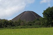
The main geological feature in this area south of Hallatrow consists of Supra-Pennant Measures which includes the upper coal measures and outcrops of sandstone. The relics of the industrial past are very evident within the area, including the widely visible and distinct conical shape of the Old Mills batch with its generally unvegetated surface. The three disused collieries in the area have subsequently been developed for light industry, a depot and a superstore.
| Colliery | Location | Coordinates | Opened | Closed | Shaft diameter (ft in (m)) | Max shaft depth (ft (m)) | Notes |
|---|---|---|---|---|---|---|---|
| Church Field (also known as Farrington of Ruett Slant) | Farrington Gurney Farrington Gurney Farrington Gurney is an English village and civil parish situated in Bath and North East Somerset unitary authority. The village lies on the junction of the A37 and the A362 in Somerset. The parish has a population of 846.-History:... |
51.3015°N 2.5228°W | 1921 | 1923 | ? | ? | Drift Mine Drift mining Drift mining is either the mining of a placer deposit by underground methods, or the working of coal seams accessed by adits driven into the surface outcrop of the coal bed. Drift is a more general mining term, meaning a near-horizontal passageway in a mine, following the bed or vein of ore. A... transferred to Marsh Lane |
| Farrington | Farrington Gurney Farrington Gurney Farrington Gurney is an English village and civil parish situated in Bath and North East Somerset unitary authority. The village lies on the junction of the A37 and the A362 in Somerset. The parish has a population of 846.-History:... |
51.3015°N 2.5228°W | 1782 | 1923 | 9 (2.7) | 588 (179.2) | |
| Marsh Lane | Farrington Gurney Farrington Gurney Farrington Gurney is an English village and civil parish situated in Bath and North East Somerset unitary authority. The village lies on the junction of the A37 and the A362 in Somerset. The parish has a population of 846.-History:... |
51.2943°N 2.5227°W | 1924 | 1955 | ? | ? | visited by the Prince of Wales Prince of Wales Prince of Wales is a title traditionally granted to the heir apparent to the reigning monarch of the United Kingdom of Great Britain and Northern Ireland and the 15 other independent Commonwealth realms... on 7 July 1934 |
| Old Mills | Midsomer Norton Midsomer Norton Midsomer Norton is a town near the Mendip Hills in Somerset, England, south-west of Bath, north-east of Wells, north-west of Frome, and south-east of Bristol. It has a population of 10,458. Along with Radstock and Westfield it used to be part of the conurbation and large civil parish of Norton... |
51.2926°N 2.5040°W | 1860 | 1966 | 11 (3.4) | 1098 (334.7) | Merged with Springfield |
| Springfield | Midsomer Norton Midsomer Norton Midsomer Norton is a town near the Mendip Hills in Somerset, England, south-west of Bath, north-east of Wells, north-west of Frome, and south-east of Bristol. It has a population of 10,458. Along with Radstock and Westfield it used to be part of the conurbation and large civil parish of Norton... |
51.2926°N 2.5040°W | 1872 | 1966 | 9 6 (2.9) | 965 (294.1) | Merged with Old Mills. Owned by W Evans and Co. |
Duchy Mines
The Duchy of CornwallDuchy of Cornwall
The Duchy of Cornwall is one of two royal duchies in England, the other being the Duchy of Lancaster. The eldest son of the reigning British monarch inherits the duchy and title of Duke of Cornwall at the time of his birth, or of his parent's succession to the throne. If the monarch has no son, the...
owned most of the mineral rights around Midsomer Norton
Midsomer Norton
Midsomer Norton is a town near the Mendip Hills in Somerset, England, south-west of Bath, north-east of Wells, north-west of Frome, and south-east of Bristol. It has a population of 10,458. Along with Radstock and Westfield it used to be part of the conurbation and large civil parish of Norton...
and various small pits opened around 1750 to exploit these.
| Colliery | Location | Coordinates | Opened | Closed | Shaft diameter (ft in (m)) | Max shaft depth (ft (m)) | Notes |
|---|---|---|---|---|---|---|---|
| Clandown | Clandown | 51.3027°N 2.4568°W | 1811 | 1929 | 6 (1.8) | 1437 (438) | 1896 owned by Trustees of the late C. Hollwey 1908 Owned by Clandown Colliery Co |
| Old Welton | Midsomer Norton Midsomer Norton Midsomer Norton is a town near the Mendip Hills in Somerset, England, south-west of Bath, north-east of Wells, north-west of Frome, and south-east of Bristol. It has a population of 10,458. Along with Radstock and Westfield it used to be part of the conurbation and large civil parish of Norton... |
51.2811°N 2.4609°W | 1783 | 1896 | 4 6 (1.4) | 1646 (501.7) | Merged with Clandown. 1896 owned by Old Welton Colliery Co. 1908 Owned by Clandown Colliery Co |
| Welton Hill | Midsomer Norton Midsomer Norton Midsomer Norton is a town near the Mendip Hills in Somerset, England, south-west of Bath, north-east of Wells, north-west of Frome, and south-east of Bristol. It has a population of 10,458. Along with Radstock and Westfield it used to be part of the conurbation and large civil parish of Norton... |
51.2972°N 2.4768°W | 1813 | 1896 | 6 (1.8) | 605 (184.4) |
Earl Waldegrave's Radstock Collieries
In 1763 coal was discovered in RadstockRadstock
Radstock is a town in Somerset, England, south west of Bath, and north west of Frome. It is within the unitary authority of Bath and North East Somerset and had a population of 5,275 according to the 2001 Census...
and mining began in the area.
The Waldegrave family
Waldegrave family
Waldegrave, the name of an English family, said to derive from Walgrave in Northamptonshire, but who long held the manor of Smallbridge in Bures St. Mary, Suffolk.Sir Richard Waldegrave served as a Knight of the Shire in 1339 in Lincolnshire...
had been Lords of the Manor
Manorialism
Manorialism, an essential element of feudal society, was the organizing principle of rural economy that originated in the villa system of the Late Roman Empire, was widely practiced in medieval western and parts of central Europe, and was slowly replaced by the advent of a money-based market...
of Radstock
Radstock
Radstock is a town in Somerset, England, south west of Bath, and north west of Frome. It is within the unitary authority of Bath and North East Somerset and had a population of 5,275 according to the 2001 Census...
since the English Civil War
English Civil War
The English Civil War was a series of armed conflicts and political machinations between Parliamentarians and Royalists...
. In 1896 the pits were owned by the Trustee of Frances, late Countess of Waldegrave.
Radstock was the terminus for the southern branch of the Somerset Coal Canal
Somerset Coal Canal
The Somerset Coal Canal was a narrow canal in England, built around 1800 from basins at Paulton and Timsbury via Camerton, an aqueduct at Dunkerton, Combe Hay, Midford and Monkton Combe to Limpley Stoke where it joined the Kennet and Avon Canal...
, which was turned into a tramway. It then became a central point for railway development with large coal depots, wash houses, workshops and a gas works. As part of the development of the Wiltshire, Somerset and Weymouth Railway an 8 miles (12.9 km) line from Radstock to Frome
Frome
Frome is a town and civil parish in northeast Somerset, England. Located at the eastern end of the Mendip Hills, the town is built on uneven high ground, and centres around the River Frome. The town is approximately south of Bath, east of the county town, Taunton and west of London. In the 2001...
was built to carry the coal. In the 1870s the broad-gauge line was converted to standard gauge and connected to the Bristol and North Somerset Line connecting it to the Great Western Railway
Great Western Railway
The Great Western Railway was a British railway company that linked London with the south-west and west of England and most of Wales. It was founded in 1833, received its enabling Act of Parliament in 1835 and ran its first trains in 1838...
. The Radstock Railway Land comprises an area of approximately 8.8 hectares of land which has been subject to planning and development applications.
| Colliery | Location | Coordinates | Opened | Closed | Shaft diameter (ft in (m)) | Max shaft depth (ft (m)) | Notes |
|---|---|---|---|---|---|---|---|
| Ludlows | Radstock Radstock Radstock is a town in Somerset, England, south west of Bath, and north west of Frome. It is within the unitary authority of Bath and North East Somerset and had a population of 5,275 according to the 2001 Census... |
51.2857°N 2.4394°W | before 1850 | 1954 | 8 | 1686 | |
| Middle Pit | Radstock Radstock Radstock is a town in Somerset, England, south west of Bath, and north west of Frome. It is within the unitary authority of Bath and North East Somerset and had a population of 5,275 according to the 2001 Census... |
51.2946°N 2.4510°W | before 1801 | 1933 | 10 (3) | 1791 (545.9) | |
| Old Pit | Radstock Radstock Radstock is a town in Somerset, England, south west of Bath, and north west of Frome. It is within the unitary authority of Bath and North East Somerset and had a population of 5,275 according to the 2001 Census... |
51.2946°N 2.4510°W | before 1800 | 1858 | 6 (1.8) | 942 (287.1) | |
| Smallcombe | Radstock Radstock Radstock is a town in Somerset, England, south west of Bath, and north west of Frome. It is within the unitary authority of Bath and North East Somerset and had a population of 5,275 according to the 2001 Census... |
51.2964°N 2.4525°W | 1797 | 1854 | 7 (2.1) | 1074 (327.4) | |
| Tyning | Radstock Radstock Radstock is a town in Somerset, England, south west of Bath, and north west of Frome. It is within the unitary authority of Bath and North East Somerset and had a population of 5,275 according to the 2001 Census... |
51.2929°N 2.4323°W | 1837 | 1909 | 8 (2.4) | 1007 (306.9) | |
| Wellsway | Westfield Westfield, Somerset Westfield is a settlement lying on the Fosse Way between Radstock and Midsomer Norton in Somerset, England. In 2011 it was raised to the status of a civil parish.... |
51.2684°N 2.4923°W | 1829 | 1920 | 4 6 (1.4) | 754 (229.8) |
Writhlington Collieries
Although these collieries were close to the Waldegrave collieries, they were further east of Radstock and under different ownership. In 1896 they were owned by Writhlington, Huish and Foxcote Colliery Co., and by 1908 this had been changed to Writhlington Collieries Co. Ltd. The Upper and Lower Writhlington, Huish & Foxcote were all merged into one colliery.The base of the Kilmersdon valley is of alluvium deposits. Above this on both sides of all of the valleys is a band of shales and clays from the Penarth Group. These rocks are from the Triassic
Triassic
The Triassic is a geologic period and system that extends from about 250 to 200 Mya . As the first period of the Mesozoic Era, the Triassic follows the Permian and is followed by the Jurassic. Both the start and end of the Triassic are marked by major extinction events...
period. The majority of the remaining upland in this area is Lias Limestone (white and blue) while the very highest part above 130 m, south of Haydon, is a small outcrop of Inferior Oolitic Limestone. All these limestones are from the Jurassic
Jurassic
The Jurassic is a geologic period and system that extends from about Mya to Mya, that is, from the end of the Triassic to the beginning of the Cretaceous. The Jurassic constitutes the middle period of the Mesozoic era, also known as the age of reptiles. The start of the period is marked by...
period. The steepest slopes of both the Kilmersdon and Snail’s Bottom valleys have frequently slipped. Below all of the area is the coal bearing Carboniferous strata. Haydon is an outlier of Radstock and was built to house the miners for the local pit. The disused railway line and inclined railway at Haydon form important elements within the Kilmersdon valley east of Haydon. The modern landscape has a less maintained and ‘rougher’ character and texture than neighbouring agricultural areas. This is caused in the main by the remnants of the coal industry and its infrastructure and changes in agricultural management. The disturbance caused by coal mining and the railways and the subsequent ending of mining and disuse of the railways has created valuable habitats of nature conservation interest.
The Writhlington spoil heap
Writhlington SSSI
Writhlington SSSI is a 0.5 hectare geological Site of Special Scientific Interest near the town of Radstock, Bath and North East Somerset, notified in 1992....
or "batch" is a now a Site of Special Scientific Interest
Site of Special Scientific Interest
A Site of Special Scientific Interest is a conservation designation denoting a protected area in the United Kingdom. SSSIs are the basic building block of site-based nature conservation legislation and most other legal nature/geological conservation designations in Great Britain are based upon...
(SSSI) because of the rich collection of fossils in the spoil heap. The Braysdown batch was planted with conifers, and is now known as Braysdown Hill. The offices, blacksmith's shop and stables at the Upper Writhlington Colliery were converted into dwellings.
| Colliery | Location | Coordinates | Opened | Closed | Shaft diameter (ft in (m)) | Max shaft depth (ft (m)) | Notes |
|---|---|---|---|---|---|---|---|
| Braysdown | Peasedown St John Peasedown St John Peasedown St John is one of the largest villages in Somerset, England. Located on a hilltop roughly south-southwest of the city of Bath, Peasedown used to be a coal mining village. When the last of the mines was shut in the 1950s it became a dormitory village for both Bath and, to a lesser... |
51.3109°N 2.4253°W | 1845 | 1959 | 10 (3) | 1834 (559) | 1896 owned by Danbeny and Scobel 1908 Owned by Braysdown Colliery Co. |
| Foxcote | Foxcote | 51.2993°N 2.4080°W | 1853 | 1931 | 9 (2.7) | 1416 (431.6) | 1896 owned by Writhlington, Huish and Foxcote Colliery Co., |
| Huish | Kilmersdon Kilmersdon Kilmersdon is a small village located in the north of Somerset between the towns of Radstock and Frome. The settlement is recorded in William I's Domesday book and dates back at least 1,000 years; though the core of the village dates from the mid nineteenth century.-History:The name Kilmersdon... |
51.2677°N 2.4221°W | 1822 | 1912 | 8 (2.4) | 570 (173.7) | 1896 owned by Writhlington, Huish and Foxcote Colliery Co., |
| Kilmersdon | Kilmersdon Kilmersdon Kilmersdon is a small village located in the north of Somerset between the towns of Radstock and Frome. The settlement is recorded in William I's Domesday book and dates back at least 1,000 years; though the core of the village dates from the mid nineteenth century.-History:The name Kilmersdon... |
51.2623°N 2.4364°W | 1875 | 1972 | 10 6 (3.2) | 1582 (482.2) | 1896 & 1908 owned by Kilmersdon Colliery Co. |
| Lower Writhlington | Writhlington Writhlington Writhlington is a suburb of Radstock and north-west of Frome in the Bath and North East Somerset district of Somerset, England.Andy Robinson taught Mathematics, Physical Education and Rugby at Writhlington School.... |
51.2947°N 2.4252°W | 1829 | 10 (3) | 1461 (445.3) | ||
| Shoscombe | Shoscombe Shoscombe Shoscombe is a small village and civil parish in the valley of the Wellow Brook in north-east Somerset, about south of Bath. The parish has a population of 462.... |
51.3064°N 2.4138°W | c1828 | by 1860 | 10 7 (3.2) | 360 (109.7) | |
| Woodborough (also known as Wodborough Old Pit) | east of Radstock Radstock Radstock is a town in Somerset, England, south west of Bath, and north west of Frome. It is within the unitary authority of Bath and North East Somerset and had a population of 5,275 according to the 2001 Census... |
51.3064°N 2.4353°W | ? | 1840s | 5 3 (1.6) | 426 (129.8) | |
| Upper Writhligton | Radstock Radstock Radstock is a town in Somerset, England, south west of Bath, and north west of Frome. It is within the unitary authority of Bath and North East Somerset and had a population of 5,275 according to the 2001 Census... |
51.2929°N 2.4323°W | 1805 | 1972 | 11 3 (3.4) | 942 (287.1) |
Norton Hill Collieries
The Norton Hill collieries at WestfieldWestfield, Somerset
Westfield is a settlement lying on the Fosse Way between Radstock and Midsomer Norton in Somerset, England. In 2011 it was raised to the status of a civil parish....
were owned by the Beauchamp family who owned other collieries and related works on the Somerset coalfield at various times. They were also known as the Beauchamp goldmines as they were the most productive mines in the whole coalfield.
In 1900 a railway was constructed to join the colliery to the main Somerset and Dorset Joint Railway
Somerset and Dorset Joint Railway
The Somerset & Dorset Joint Railway – almost always referred to as "the S&D" – was an English railway line connecting Bath in north east Somerset and Bournemouth now in south east Dorset but then in Hampshire...
, with additional sidings being laid in 1905 and 1907 which were relaid in 1953.
On 9 April 1908 an explosion approximately 1500 feet (457.2 m) underground killed 10 men and boys. As there were no organised mine rescue teams the manager and volunteers searched for 10 days for survivors. In 1911, partly as a result of the Norton Hill explosion, Winston Churchill
Winston Churchill
Sir Winston Leonard Spencer-Churchill, was a predominantly Conservative British politician and statesman known for his leadership of the United Kingdom during the Second World War. He is widely regarded as one of the greatest wartime leaders of the century and served as Prime Minister twice...
was instrumental in the passing of the Coal Mines Act 1911.
Following nationalisation after World War II
World War II
World War II, or the Second World War , was a global conflict lasting from 1939 to 1945, involving most of the world's nations—including all of the great powers—eventually forming two opposing military alliances: the Allies and the Axis...
the National Coal Board spent £500,000 on new infrastructure modernising the mine to have a capability for annual production of 315,000 tons, however manpower shortages and geological problems meant that it closed in 1966.
| Colliery | Location | Coordinates | Opened | Closed | Shaft diameter (ft in (m)) | Max shaft depth (ft (m)) | Notes |
|---|---|---|---|---|---|---|---|
| Norton Hill New | Westfield Westfield, Somerset Westfield is a settlement lying on the Fosse Way between Radstock and Midsomer Norton in Somerset, England. In 2011 it was raised to the status of a civil parish.... |
51.2801°N 2.4810°W | 1903 | 1966 | 13 6 | 1503 | |
| Norton Hill Old | Westfield Westfield, Somerset Westfield is a settlement lying on the Fosse Way between Radstock and Midsomer Norton in Somerset, England. In 2011 it was raised to the status of a civil parish.... |
51.2801°N 2.4810°W | before 1839 | 4 6 | 1247 | In 1908 10 men were killed in a major coal dust explosion. |
Nettlebridge Valley
There were hundreds of small coal workings in the area from Gurney SladeAshwick
Ashwick is a village in the Mendip district of Somerset, England, about three miles north of Shepton Mallet and seven miles east from Wells. It has also been a civil parish since 1826...
east to Mells
Mells, Somerset
Mells is a village and civil parish in Somerset, England, near the town of Frome.The parish includes the village of Vobster which had a coal mine of the same name on the Somerset coalfield and quarry, both of which are now disused. The old quarry is now used as a diving centre...
including the villages of Holcombe
Holcombe, Somerset
Holcombe is a small village and civil parish in the Mendip local government district of Somerset, England. The parish contains the hamlets of Barlake and Edford...
, Coleford
Coleford, Somerset
Coleford is a village and civil parish in Somerset, England, situated on the Mells River in the Mendip Hills five miles west of Frome. The village has a population of 2,350.-History:...
and Stratton-on-the-Fosse
Stratton-on-the-Fosse
Stratton-on-the-Fosse is a village and civil parish located on the edge of the Mendip Hills, south-west of Westfield, north-east of Shepton Mallet, and from Frome, in Somerset, England. It has a population 1,045, and has a rural agricultural landscape, although it was part of the once-thriving...
. These included at least 52 Bell pits with some deeper shafts and 16 adits. Although some coal may have been mined in the area during Roman
Roman Britain
Roman Britain was the part of the island of Great Britain controlled by the Roman Empire from AD 43 until ca. AD 410.The Romans referred to the imperial province as Britannia, which eventually comprised all of the island of Great Britain south of the fluid frontier with Caledonia...
times and they expanded in the 13th century, making them the earliest coal mines known in Somerset, most of the development occurred in the 17th century. Most mining finished in the 19th century, however Strap Colliery was opened in 1953 as Mendip Colliery and worked until 1969.
The Vobster Breach colliery had a nationally unique system of long coking ovens which, along with the other surviving buildings, have since been designated as a Scheduled monument. The boiler chimney of Oxley's Colliery which only operated for a few years in the 1880s, near Buckland Dinham
Buckland Dinham
Buckland Dinham is a small village near Frome in Somerset, England. The village has a population of 379. The village's main industry is farming , but the village is also a dormitory village for the nearby cities of Bath and Bristol.-History:...
is a Grade II listed building.
| Colliery | Location | Coordinates | Opened | Closed | Shaft diameter (ft in (m)) | Max shaft depth (ft (m)) | Notes |
|---|---|---|---|---|---|---|---|
| Barlake | Nettlebridge | 51.2342°N 2.5020°W | before 1819 | 1870 | 5 6 (1.7) | 435 (132.6) | |
| Bilboa | Mells Mells, Somerset Mells is a village and civil parish in Somerset, England, near the town of Frome.The parish includes the village of Vobster which had a coal mine of the same name on the Somerset coalfield and quarry, both of which are now disused. The old quarry is now used as a diving centre... |
51.2489°N 2.4147°W | ? | ? | ? | 240 (73.2) | |
| Breach | Vobster | 51.2389°N 2.4333°W | 1860 | c1880 | ? | 867 (264.2) | |
| Charmborough | Holcombe Holcombe, Somerset Holcombe is a small village and civil parish in the Mendip local government district of Somerset, England. The parish contains the hamlets of Barlake and Edford... |
51.2632°N 2.4478°W | 1932 | 1947 | ? | ? | |
| Coal Barton | Coleford Coleford, Somerset Coleford is a village and civil parish in Somerset, England, situated on the Mells River in the Mendip Hills five miles west of Frome. The village has a population of 2,350.-History:... |
51.2487°N 2.4591°W | ? | ? | ? | ? | Scene of a firedamp Firedamp Firedamp is a flammable gas found in coal mines. It is the name given to a number of flammable gases, especially methane. It is particularly commonly found in areas where the coal is bituminous... explosion which killed nine miners in 1869 |
| Edford | Holcombe Holcombe, Somerset Holcombe is a small village and civil parish in the Mendip local government district of Somerset, England. The parish contains the hamlets of Barlake and Edford... |
51.2397°N 2.4734°W | 1850s | 1915 | 6 (1.8) | 798 (243.2) | |
| Holcombe | Holcombe Holcombe, Somerset Holcombe is a small village and civil parish in the Mendip local government district of Somerset, England. The parish contains the hamlets of Barlake and Edford... |
51.2397°N 2.4734°W | 1914 | 1923 | ? | ? | |
| Luckington | Coleford Coleford, Somerset Coleford is a village and civil parish in Somerset, England, situated on the Mells River in the Mendip Hills five miles west of Frome. The village has a population of 2,350.-History:... |
51.2542°N 2.4377°W | ? | ? | 6 (1.8) | 135 (41.4) | |
| Mackintosh | Coleford Coleford, Somerset Coleford is a village and civil parish in Somerset, England, situated on the Mells River in the Mendip Hills five miles west of Frome. The village has a population of 2,350.-History:... |
51.2470°N 2.4362°W | 1867 | 1919 | 8 5 (2.6) | 1620 (493.8) | Merged with Newbury. 1896 owned by Westbury Iron Co. Ltd., |
| Mells | Mells Mells, Somerset Mells is a village and civil parish in Somerset, England, near the town of Frome.The parish includes the village of Vobster which had a coal mine of the same name on the Somerset coalfield and quarry, both of which are now disused. The old quarry is now used as a diving centre... |
51.2588°N 2.4120°W | 1860s till 1880s | reopened 1909 till 1943 | 9 (2.7) | 540 (164.6) | |
| Morewood Old | Nettlebridge | 51.2440°N 2.5135°W | before 1824 | 1860s | 4 6 (1.4) | 1247 (380) | |
| Morewood New | Nettlebridge | 51.2440°N 2.5135°W | 1860s | 1932 | 9 (2.7) | 888 (26.8) | |
| Nettlebridge | Nettlebridge | 51.2342°N 2.5020°W | before 1831 | ? | 6 (1.8) | 705 (214.9) | |
| Newbury | Coleford Coleford, Somerset Coleford is a village and civil parish in Somerset, England, situated on the Mells River in the Mendip Hills five miles west of Frome. The village has a population of 2,350.-History:... |
51.2542°N 2.4377°W | 1799 | 1927 | 9 (2.7) | 720 (219.4) | Merged with Mackintosh. 1896 owned by Westbury Iron Co. Ltd., 1908 Owned by John Wainwright and Co. Ltd. |
| New Rock | Stratton-on-the-Fosse Stratton-on-the-Fosse Stratton-on-the-Fosse is a village and civil parish located on the edge of the Mendip Hills, south-west of Westfield, north-east of Shepton Mallet, and from Frome, in Somerset, England. It has a population 1,045, and has a rural agricultural landscape, although it was part of the once-thriving... |
51.2539°N 2.5036°W | 1819 | 1968 | 4 6 (1.4) | 1182 (360.3) | |
| Old Newbury | Coleford Coleford, Somerset Coleford is a village and civil parish in Somerset, England, situated on the Mells River in the Mendip Hills five miles west of Frome. The village has a population of 2,350.-History:... |
51.2542°N 2.4377°W | c1710 | 1790s | ? | 250 (76.2) | |
| Old Rock | Nettlebridge | 51.2440°N 2.5035°W | 1786 | 1873 | 4 6 (1.4) | 711 (216.7) | |
| Pitcot | Nettlebridge | 51.2432°N 2.4935°W | before 1750 | c1820s | 5 (1.5) | 555 (169.2) | |
| Strap (also known as Mendip or Downside Colliery) | Nettlebridge | 51.2413°N 2.5078°W | 1863 | 1879 | 10 6 (3.2) | 1838 (560.2) | Deepest shaft on the Somerset coalfield. Reopened in 1953 and worked until 1969. |
| Sweetleaze | Nettlebridge | 51.2413°N 2.5078°W | before 1858 | 1879 | ? | ? | |
| Vobster | Vobster | 51.2408°N 2.4233°W | before 1850s | 1884 | 10 (3) | 990 (301.8) | Had nationally unique long coking oven design. |