

North Cascades
Encyclopedia
The North Cascades are a section of the Cascade Range of western North America
. They span the border between the Canadian
province of British Columbia
and the U.S. state
of Washington and are officially named in Canada as the Cascade Mountains. They are predominantly non-volcanic, but include the stratovolcano
es Mount Baker
, Glacier Peak
and Coquihalla Mountain
, which are part of the Cascade Volcanic Arc
. The portion in Canada is known as the Canadian Cascades, a designation that also includes the mountains above the east bank of the Fraser Canyon
as far north as the town of Lytton
, at the confluence of the Thompson
and Fraser River
s.
The US portion of the North Cascades and the adjoining Skagit Range
in British Columbia are most notable for their dramatic scenery and challenging mountaineering
, both resulting from their steep, rugged topography
. While most of the peaks are under 10000 feet (3,048 m) in elevation
, the low valley
s provide great local relief, often over 6000 feet (1,828.8 m). The summits of the rest of the Canadian Cascades are not glaciated in the same way and feature rock "horns" rising from plateau-like uplands, with the Manning Park and Cathedral Park areas known for their extensive alpine meadows, as is also the case with the eastern flank of the US portion of the range.
The large amount of precipitation
, much of it in the form of snow
, and the resulting glaciation
, combine with the regional uplift
to create a dramatic landscape
in the western part of the range. Deep, U-shaped valley
s carved by glaciers in Pleistocene
time separate sharp ridges and peaks carved into steep shapes by more recent snow and ice. The eastern and northernmost parts of the range are much more plateau-like in character, though in the case of the northernmost areas graven by deep valleys along the flank of the Fraser Canyon, notably that of the Anderson River
.
and the adjoining lowland on its south bank form the northern and northwestern boundary of the range. On the east, the Okanogan River
and the Columbia River
bound the range in the United States, while the northeastern boundary of the range departs the Thompson via the Nicoamen River
and runs via Lawless Creek, the Tulameen River
and Copper Creek to the Similkameen River
. On the west, the foothills of the range are separated by a narrow coastal plain from Puget Sound
except along Chuckanut Drive between Bellingham
and Mount Vernon
, where they abut the Sound directly.
The southern boundary of the North Cascades is less definite. For the purposes of this article, it will be taken as U.S. Highway 2
, running over Stevens Pass
, or equivalently, the Skykomish River
, Nason Creek, and the lower Wenatchee River
. This roughly follows Beckey's
geologic division in Cascade Alpine Guide
. and the definition used by Peakbagger.com. Sometimes the southern boundary is defined by Snoqualmie Pass and the approximate route of Interstate 90
. Sometimes the term "North Cascades" or "northern Cascades" is used for the entire range north of the Columbia River
.
Geologically, the rocks of the North Cascades extend south beyond Stevens Pass and west into the San Juan Islands
. The significance of the geologic transitions to the Okanagan Highland
to the east and the Interior Plateau
and Coast Mountains
to the north are less agreed upon.
in the North Cascades varies considerably by location and elevation. The western slope of the range is wet and cool, with 60 to 250 in (1.5 to 6.4 m) of precipitation per year. This produces a temperate rain forest
climate in the low valleys, which then grades into montane
and alpine climate
s on mountain slopes and peaks. Summers are comparatively dry, with far less precipitation than in winter. The eastern slope lies in the rain shadow
of the range, since prevailing winds and most moisture come from the west, and hence is significantly drier than the western side of the main divide, becoming semi-arid
in the eastern lowlands. As with most mountain areas, precipitation increases dramatically with increasing elevation. As a result, there is a great deal of winter snow
and glaciation
in the high North Cascades.
The eastern slopes and mountain passes can receive significant snowfall. Cold Arctic air can flow south from British Columbia
through the Okanogan River
valley into the bowl-like basin east of the Cascades. Cold air damming
causes this Arctic air to bank up along the eastern Cascade slopes, especially into the lower passes, such as Snoqualmie Pass
and Stevens Pass
. The milder, Pacific-influenced air moving east over the Cascades is often forced aloft by the cold air held in place in the passes due to cold air damming. As a result, the passes often receive more snow than higher areas in the Cascades. This effect makes the relatively low elevation ski resorts at Snoqualmie Pass (about 3000 feet (914.4 m)) and Stevens Pass (about 4000 feet (1,219.2 m)) possible.
, structurally complex pre-Tertiary
rocks
". These originated in diverse locations around the globe: the area is built of several ("perhaps ten or more") different terrane
s of different ages and origins. These terranes are separated by a series of ancient faults, the most significant being the Straight Creek Fault, which runs north-south from north of Yale, British Columbia
, through Hope
, Marblemount, Washington
, and down to Kachess Lake
near Snoqualmie Pass. There is evidence of significant strike-slip movement on this fault in the past, with similar rocks on either side of the fault separated by dozens of miles. This is thought to be related to northward tectonic movement of the West Coast relative to the rest of North America.
Since about 35 million years ago, oceanic crust
from the Pacific Ocean
has been subducting
under the continental margin
, which has formed the current volcano
es as well as a number of igneous intrusion
s composed of diorite
and gabbro
. The current uplift
of the Cascade Range began around 8 million years ago.
Rocks similar to those in the North Cascades continue north to the vicinity of Mount Meager
in the Coast Mountains
, where they abut the Stikinia Terrane of the Omineca-Intermontane Province that dominates the Interior Plateau
of British Columbia. This geologic similarity between the North Cascades and Coast Mountains results in a fairly arbitrary boundary between the two.
In British Columbia, the western geologic boundary of the North Cascades is defined as the Fraser River
as it follows the Straight Creek Fault, while in the United States the western boundary is defined by the Puget Lowlands in the west, although there are significant westward extensions of rocks similar in origin to those in the North Cascades found in the San Juan Islands
.
The eastern geologic boundary of the North Cascades may be marked by the Chewack-Pasayten Fault. This fault separates the easternmost portion of the North Cascades, the Methow Terrane, from the Quesnellia Terrane, one of the Omineca and Intermontane Belt
s. The fault also separates the Methow River
valley, part of the Methow Terrane, from the Okanagan Range
, part of the Quesnellia Terrane. The Columbia River Basalt Group
bounds the North Cascades to the southeast.
The southern limit of what is geologically considered the "North Cascades" may variously be defined as being the southern limit of eposure of igneous and metamorphic terranes which is generally north of Snoqualmie Pass, Snoqualmie Pass itself, or Naches Pass
at the White River Fault Zone.
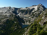
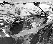
 While alpine glaciers are a defining feature of the Cascade Range as a whole, this is especially true of the North Cascades. The stratovolcanoes (Mount Baker and Glacier Peak) are the most obviously glaciated peaks and have the largest glaciers, but many of the smaller, nonvolcanic peaks are glaciated as well. For example, the portion of the Cascades north of Snoqualmie Pass
(roughly the North Cascades as defined in this article) These glaciers all retreated from 1900-1950. From 1950-1975 many but not all North Cascades glaciers advanced. Since 1975 retreat has become more rapid with all 107 glaciers monitored retreating by 1992. There are approximately 700 glaciers in the range, though some have already disappeared. Since a brief advancing period in the 1950s, most of these glaciers have been retreating
. This is a serious concern to water managers in the region, as the glaciers (and the winter snowpack) form a large reservoir of water
. As snow and ice melts in the summer, the resulting meltwater
compensates for the seasonal decrease in precipitation. As glaciers retreat they will provide less summer runoff.
The Cascades north of Snoqualmie Pass have 756 glaciers covering 103 square miles (266.8 km²) of terrain. For comparison, the entire contiguous United States
has about 1,100 glaciers in total, covering 205 square miles (530.9 km²).
 The ecology of the North Cascades can be interpreted by following a west-to-east line at the southern end of the North Cascades, at approximately 47.5 degrees north. As the line passes through the Cascade range, it intersects a number of distinct ecoregions, first getting higher and colder, then getting warmer, yet drier. Each of these component ecoregions can be described by either a tree indicator species
, or by a lack of trees: Western Hemlock
, Silver Fir
, Subalpine Mountain Hemlock
, Alpine tundra
, Subalpine Fir
, and Grand Fir
/Douglas-fir
.
Within the North Cascades there is also a diverse faunal population including mammal
s, birds, reptile
s and amphibian
s. Examples of amphibian species occurring in the North Cascades include Bufo boreas and the Rough-skinned newt, Taricha granulosa, whose population in the North Cascades has the unusual feature that approximately ninety percent of adults are perennibranchiate
.
 On the United States side of the border, early inhabitants of the North Cascades included the Nooksack
, Skagit
, and Sauk-Suiattle
tribes on the west, and the Okanagan people
on the eastern side, with the Nlaka'pamux
people of what is now Canada claiming hunting territory in the heart of the range, south across the border into Washington. The tribes living and using the range on the Canadian side of the border are the Nlaka'pamux
, Sto:lo
and the Upper
and Lower Similkameen
subgroups of the Okanagan. A now-extinct group known as the Nicola Athapaskans
also inhabited and hunted in the area now occupied by the Similkameen. Many current geographic names in the region are derived from native terms, either by transliteration or translation. Beckey notes that "Many names were derived from Chinook Jargon
, mostly applied by the United States Forest Service
from 1910 to 1940...."
Fur traders entered the area in the first half of the 19th century, coming from Canada
and from Astoria
on the Columbia River
. One of the earliest was Alexander Ross
of the North West Company
, who crossed the range in the summer of 1814, probably via Cascade Pass
. The period of uncertainty surrounding the disputed Oregon Country
gave way following partition along the 49th Parallel to a period of tentative U.S. Army
exploration in tandem with violent subjugation of Indian tribes on the American side of the frontier in the second half of the century. With the partition, the Hudson's Bay Company
was forced to seek an alternative to its older Brigade Trail
via the Okanogan River
and the construction of a new route over the northern spine of the Canadian Cascades from the area of Spuzzum
into the valley of the Coldwater River
to connect fort Langley
on the lower Fraser with its northern posts in New Caledonia
. The route was impracticable and was soon abandoned, though more southerly routes through what is now Manning Park laid the foundations for later routes such as the Dewdney Trail and the modern Crowsnest Highway
via Allison Pass
, and was later similar to a route via the Coquihalla Pass
for its southern mainline
. South of the boundary, reconnaissance for possible railroad routes (none of which were viable north of the one eventually put in over Stevens Pass, at the southern edge of the North Cascades) and various mining rushes.
Miners dominated the exploration and development of the range from the 1880s through the early 20th century. For example, mines around the boomtown of Monte Cristo
, in the southwest portion of the North Cascades, produced "between $1 and $2.7 million in silver and gold". The Holden Mine
, on the east side of the main divide, produced 106,000 tons of copper and 600,000 ounces of gold. Discovery of gold by American prospectors on the banks of the Thompson River
at its confluence with the Nicoamen River
, at the northern tip of the range, helped trigger the Fraser Canyon Gold Rush
of 1858-1860 which in turn prompted the declaration of the Colony of British Columbia
to affirm British possession of territories north of the 49th Parallel. The Fraser rush led to exploration of the Cascades to the east of the canyon and in the valley of the Similkameen River
, with minor rushss in the area of Princeton, British Columbia
in 1859 through the early 1860s and the creation of non-native towns (on top of much older native ones) at Boston Bar
, Lytton
and Hope
, as well as Princeton.
Early settlers also arrived in the foothills of the North Cascades in the latter half of the 19th century, and utilized the range in a limited way as a source of timber and grazing land. However, the range is so rugged that this exploitation was less dramatic than in other more gentle landscapes.
Early recreational use of the range included expeditions by the local climbing
clubs, The Mountaineers
and The Mazamas
. However even these groups did not fully explore the inner reaches of the range and ascend the most difficult peaks until the 1930s and 1940s.
North America
North America is a continent wholly within the Northern Hemisphere and almost wholly within the Western Hemisphere. It is also considered a northern subcontinent of the Americas...
. They span the border between the Canadian
Canada
Canada is a North American country consisting of ten provinces and three territories. Located in the northern part of the continent, it extends from the Atlantic Ocean in the east to the Pacific Ocean in the west, and northward into the Arctic Ocean...
province of British Columbia
British Columbia
British Columbia is the westernmost of Canada's provinces and is known for its natural beauty, as reflected in its Latin motto, Splendor sine occasu . Its name was chosen by Queen Victoria in 1858...
and the U.S. state
U.S. state
A U.S. state is any one of the 50 federated states of the United States of America that share sovereignty with the federal government. Because of this shared sovereignty, an American is a citizen both of the federal entity and of his or her state of domicile. Four states use the official title of...
of Washington and are officially named in Canada as the Cascade Mountains. They are predominantly non-volcanic, but include the stratovolcano
Stratovolcano
A stratovolcano, also known as a composite volcano, is a tall, conical volcano built up by many layers of hardened lava, tephra, pumice, and volcanic ash. Unlike shield volcanoes, stratovolcanoes are characterized by a steep profile and periodic, explosive eruptions...
es Mount Baker
Mount Baker
Mount Baker , also known as Koma Kulshan or simply Kulshan, is an active glaciated andesitic stratovolcano in the Cascade Volcanic Arc and the North Cascades of Washington State in the United States. It is the second-most active volcano in the range after Mount Saint Helens...
, Glacier Peak
Glacier Peak
Glacier Peak is the most isolated of the five major stratovolcanoes of the Cascade Volcanic Arc in Washington...
and Coquihalla Mountain
Coquihalla Mountain
Coquihalla Mountain is an extinct stratovolcano in Similkameen Country, southwestern British Columbia, Canada, located south of Falls Lake and west of Tulameen between the Coquihalla and Tulameen rivers. With a topographic prominence of , it towers above adjacent mountain ridges...
, which are part of the Cascade Volcanic Arc
Cascade Volcanoes
The Cascade Volcanoes are a number of volcanoes in a volcanic arc in western North America, extending from southwestern British Columbia through Washington and Oregon to Northern California, a distance of well over 700 mi ...
. The portion in Canada is known as the Canadian Cascades, a designation that also includes the mountains above the east bank of the Fraser Canyon
Fraser Canyon
The Fraser Canyon is an 84 km landform of the Fraser River where it descends rapidly through narrow rock gorges in the Coast Mountains en route from the Interior Plateau of British Columbia to the Fraser Valley...
as far north as the town of Lytton
Lytton, British Columbia
Lytton in British Columbia, Canada, sits at the confluence of the Thompson River and Fraser River on the east side of the Fraser. The location has been inhabited by the Nlaka'pamux people for over 10,000 years, and is one of the earliest locations settled by non-natives in the Southern Interior of...
, at the confluence of the Thompson
Thompson River
The Thompson River is the largest tributary of the Fraser River, flowing through the south-central portion of British Columbia, Canada. The Thompson River has two main branches called the South Thompson and the North Thompson...
and Fraser River
Fraser River
The Fraser River is the longest river within British Columbia, Canada, rising at Fraser Pass near Mount Robson in the Rocky Mountains and flowing for , into the Strait of Georgia at the city of Vancouver. It is the tenth longest river in Canada...
s.
The US portion of the North Cascades and the adjoining Skagit Range
Skagit Range
The Skagit Range is a subrange of the Cascade Range in southwestern British Columbia, Canada and northwestern Washington, United States, which are known in Canada as the Canadian Cascades or, officially, the Cascade Mountains...
in British Columbia are most notable for their dramatic scenery and challenging mountaineering
Mountaineering
Mountaineering or mountain climbing is the sport, hobby or profession of hiking, skiing, and climbing mountains. While mountaineering began as attempts to reach the highest point of unclimbed mountains it has branched into specialisations that address different aspects of the mountain and consists...
, both resulting from their steep, rugged topography
Topography
Topography is the study of Earth's surface shape and features or those ofplanets, moons, and asteroids...
. While most of the peaks are under 10000 feet (3,048 m) in elevation
Elevation
The elevation of a geographic location is its height above a fixed reference point, most commonly a reference geoid, a mathematical model of the Earth's sea level as an equipotential gravitational surface ....
, the low valley
Valley
In geology, a valley or dale is a depression with predominant extent in one direction. A very deep river valley may be called a canyon or gorge.The terms U-shaped and V-shaped are descriptive terms of geography to characterize the form of valleys...
s provide great local relief, often over 6000 feet (1,828.8 m). The summits of the rest of the Canadian Cascades are not glaciated in the same way and feature rock "horns" rising from plateau-like uplands, with the Manning Park and Cathedral Park areas known for their extensive alpine meadows, as is also the case with the eastern flank of the US portion of the range.
Geography
The large amount of precipitation
Precipitation (meteorology)
In meteorology, precipitation In meteorology, precipitation In meteorology, precipitation (also known as one of the classes of hydrometeors, which are atmospheric water phenomena is any product of the condensation of atmospheric water vapor that falls under gravity. The main forms of precipitation...
, much of it in the form of snow
Snow
Snow is a form of precipitation within the Earth's atmosphere in the form of crystalline water ice, consisting of a multitude of snowflakes that fall from clouds. Since snow is composed of small ice particles, it is a granular material. It has an open and therefore soft structure, unless packed by...
, and the resulting glaciation
Glacier
A glacier is a large persistent body of ice that forms where the accumulation of snow exceeds its ablation over many years, often centuries. At least 0.1 km² in area and 50 m thick, but often much larger, a glacier slowly deforms and flows due to stresses induced by its weight...
, combine with the regional uplift
Tectonic uplift
Tectonic uplift is a geological process most often caused by plate tectonics which increases elevation. The opposite of uplift is subsidence, which results in a decrease in elevation. Uplift may be orogenic or isostatic.-Orogenic uplift:...
to create a dramatic landscape
Landscape
Landscape comprises the visible features of an area of land, including the physical elements of landforms such as mountains, hills, water bodies such as rivers, lakes, ponds and the sea, living elements of land cover including indigenous vegetation, human elements including different forms of...
in the western part of the range. Deep, U-shaped valley
U-shaped valley
A U-shaped valley also known as a glacial trough is one formed by the process of glaciation. It has a characteristic U-shape, with steep, straight sides, and a flat bottom. Glaciated valleys are formed when a glacier travels across and down a slope, carving the valley by the action of scouring...
s carved by glaciers in Pleistocene
Pleistocene
The Pleistocene is the epoch from 2,588,000 to 11,700 years BP that spans the world's recent period of repeated glaciations. The name pleistocene is derived from the Greek and ....
time separate sharp ridges and peaks carved into steep shapes by more recent snow and ice. The eastern and northernmost parts of the range are much more plateau-like in character, though in the case of the northernmost areas graven by deep valleys along the flank of the Fraser Canyon, notably that of the Anderson River
Anderson River (British Columbia)
The Anderson River is a tributary of the Fraser River in the Canadian province of British Columbia.The river is presumably named after Alexander Caulfield Anderson of the Hudson's Bay Company who traveled through the region in 1847-48.-Course:...
.
Extent
The Fraser RiverFraser River
The Fraser River is the longest river within British Columbia, Canada, rising at Fraser Pass near Mount Robson in the Rocky Mountains and flowing for , into the Strait of Georgia at the city of Vancouver. It is the tenth longest river in Canada...
and the adjoining lowland on its south bank form the northern and northwestern boundary of the range. On the east, the Okanogan River
Okanogan River
The Okanogan River is a tributary of the Columbia River, approximately 115 mi long, in southern British Columbia and north central Washington...
and the Columbia River
Columbia River
The Columbia River is the largest river in the Pacific Northwest region of North America. The river rises in the Rocky Mountains of British Columbia, Canada, flows northwest and then south into the U.S. state of Washington, then turns west to form most of the border between Washington and the state...
bound the range in the United States, while the northeastern boundary of the range departs the Thompson via the Nicoamen River
Nicoamen River
The Nicoamen River is a tributary of the Thompson River in the southern Interior of British Columbia, Canada, located 15 km upstream from its confluence with the Thompson at Lytton....
and runs via Lawless Creek, the Tulameen River
Tulameen River
The Tulameen River is a tributary of the Similkameen River in the Canadian province of British Columbia. The Tulameen River is part of the Columbia River drainage basin, being a tributary of the Similkameen River, which flows into the Okanagan River, which flows into the Columbia River.-Course:The...
and Copper Creek to the Similkameen River
Similkameen River
The Similkameen River runs through southern British Columbia, eventually discharging into the Okanogan River near Oroville, Washington in the United States. The river is approximately long, and its drainage basin is in area...
. On the west, the foothills of the range are separated by a narrow coastal plain from Puget Sound
Puget Sound
Puget Sound is a sound in the U.S. state of Washington. It is a complex estuarine system of interconnected marine waterways and basins, with one major and one minor connection to the Strait of Juan de Fuca and the Pacific Ocean — Admiralty Inlet being the major connection and...
except along Chuckanut Drive between Bellingham
Bellingham, Washington
Bellingham is the largest city in, and the county seat of, Whatcom County in the U.S. state of Washington. It is the twelfth-largest city in the state. Situated on Bellingham Bay, Bellingham is protected by Lummi Island, Portage Island, and the Lummi Peninsula, and opens onto the Strait of Georgia...
and Mount Vernon
Mount Vernon, Washington
Mount Vernon is a city in Skagit County, Washington, United States. The population was 31,743 at the 2010 census. It is one of two principal cities of and included in the Mount Vernon-Anacortes, Washington Metropolitan Statistical Area. It is the county seat of Skagit County...
, where they abut the Sound directly.
The southern boundary of the North Cascades is less definite. For the purposes of this article, it will be taken as U.S. Highway 2
U.S. Route 2 in Washington
U.S. Route 2 is a part of the United States Numbered Highway System that has a western segment that runs from Everett, Washington, to the Upper Peninsula of the US state of Michigan. In Washington, it is a state highway that begins at in Downtown Everett. The of US 2 that lie within...
, running over Stevens Pass
Stevens Pass
Stevens Pass is a mountain pass through the Cascade Mountains located at the border of King County and Chelan County in Washington, United States....
, or equivalently, the Skykomish River
Skykomish River
The Skykomish River is a Washington river which drains the west side of the Cascade Mountains in the southeast section of Snohomish County and the northeast corner of King County. The river starts with the confluence of the North Fork Skykomish River and South Fork Skykomish River approximately one...
, Nason Creek, and the lower Wenatchee River
Wenatchee River
The Wenatchee River is a river in the U.S. state of Washington, originating at Lake Wenatchee and flowing southeast for , emptying into the Columbia River immediately north of Wenatchee, Washington...
. This roughly follows Beckey's
Fred Beckey
Fred Beckey is an American mountaineer and author, who has made hundreds of first ascents, more than any other North American climber.-Early years:...
geologic division in Cascade Alpine Guide
Cascade Alpine Guide
The Cascade Alpine Guides are a series of three climbing guides written by Fred Beckey, longtime explorer and climber of the Cascade Mountains in Washington and British Columbia. The guides outline routes to summit every peak of any significance in the region. Many photos in the books were taken...
. and the definition used by Peakbagger.com. Sometimes the southern boundary is defined by Snoqualmie Pass and the approximate route of Interstate 90
Interstate 90 in Washington
Interstate 90 , a transcontinental Interstate Highway from Seattle, Washington, to Boston, Massachusetts, crosses the state of Washington before crossing the Idaho state line between Spokane and Post Falls...
. Sometimes the term "North Cascades" or "northern Cascades" is used for the entire range north of the Columbia River
Columbia River
The Columbia River is the largest river in the Pacific Northwest region of North America. The river rises in the Rocky Mountains of British Columbia, Canada, flows northwest and then south into the U.S. state of Washington, then turns west to form most of the border between Washington and the state...
.
Geologically, the rocks of the North Cascades extend south beyond Stevens Pass and west into the San Juan Islands
San Juan Islands
The San Juan Islands are an archipelago in the northwest corner of the contiguous United States between the US mainland and Vancouver Island, British Columbia, Canada. The San Juan Islands are part of the U.S...
. The significance of the geologic transitions to the Okanagan Highland
Okanagan Highland
The Okanagan Highland is a plateau-like hilly area in British Columbia, Canada, and the U.S. state of Washington . It lies between the Okanagan Valley on its west and the Kettle River on its east, and geologically is more or less an extension of the Thompson Plateau, which lies west of the Okanagan...
to the east and the Interior Plateau
Interior Plateau
The Interior Plateau comprises a large region of central British Columbia, and lies between the Cariboo and Monashee Mountains on the east, and the Hazelton Mountains, Coast Mountains and Cascade Range on the west. The continuation of the plateau into the United States is known there as the...
and Coast Mountains
Coast Mountains
The Coast Mountains are a major mountain range, in the Pacific Coast Ranges, of western North America, extending from southwestern Yukon through the Alaska Panhandle and virtually all of the Coast of British Columbia. They are so-named because of their proximity to the sea coast, and are often...
to the north are less agreed upon.
Climate
The climateClimate
Climate encompasses the statistics of temperature, humidity, atmospheric pressure, wind, rainfall, atmospheric particle count and other meteorological elemental measurements in a given region over long periods...
in the North Cascades varies considerably by location and elevation. The western slope of the range is wet and cool, with 60 to 250 in (1.5 to 6.4 m) of precipitation per year. This produces a temperate rain forest
Temperate rain forest
Temperate rainforests are coniferous or broadleaf forests that occur in the temperate zone and receive high rainfall.-Definition:For temperate rain forests of North America, Alaback's definition is widely recognized:-Global distribution:...
climate in the low valleys, which then grades into montane
Montane
In biogeography, montane is the highland area located below the subalpine zone. Montane regions generally have cooler temperatures and often have higher rainfall than the adjacent lowland regions, and are frequently home to distinct communities of plants and animals.The term "montane" means "of the...
and alpine climate
Alpine climate
Alpine climate is the average weather for a region above the tree line. This climate is also referred to as mountain climate or highland climate....
s on mountain slopes and peaks. Summers are comparatively dry, with far less precipitation than in winter. The eastern slope lies in the rain shadow
Rain shadow
A rain shadow is a dry area on the lee side of a mountainous area. The mountains block the passage of rain-producing weather systems, casting a "shadow" of dryness behind them. As shown by the diagram to the right, the warm moist air is "pulled" by the prevailing winds over a mountain...
of the range, since prevailing winds and most moisture come from the west, and hence is significantly drier than the western side of the main divide, becoming semi-arid
Semi-arid
A semi-arid climate or steppe climate describes climatic regions that receive precipitation below potential evapotranspiration, but not extremely...
in the eastern lowlands. As with most mountain areas, precipitation increases dramatically with increasing elevation. As a result, there is a great deal of winter snow
Snow
Snow is a form of precipitation within the Earth's atmosphere in the form of crystalline water ice, consisting of a multitude of snowflakes that fall from clouds. Since snow is composed of small ice particles, it is a granular material. It has an open and therefore soft structure, unless packed by...
and glaciation
Glacier
A glacier is a large persistent body of ice that forms where the accumulation of snow exceeds its ablation over many years, often centuries. At least 0.1 km² in area and 50 m thick, but often much larger, a glacier slowly deforms and flows due to stresses induced by its weight...
in the high North Cascades.
The eastern slopes and mountain passes can receive significant snowfall. Cold Arctic air can flow south from British Columbia
British Columbia
British Columbia is the westernmost of Canada's provinces and is known for its natural beauty, as reflected in its Latin motto, Splendor sine occasu . Its name was chosen by Queen Victoria in 1858...
through the Okanogan River
Okanogan River
The Okanogan River is a tributary of the Columbia River, approximately 115 mi long, in southern British Columbia and north central Washington...
valley into the bowl-like basin east of the Cascades. Cold air damming
Cold air damming
Cold air damming, or CAD, is a meteorological phenomenon that involves a high pressure system interacting with local geographic features. A cold-air damming situation typically involves a high pressure system located poleward of a mountain range...
causes this Arctic air to bank up along the eastern Cascade slopes, especially into the lower passes, such as Snoqualmie Pass
Snoqualmie Pass
Snoqualmie Pass is a mountain pass that carries Interstate 90 through the Cascade Range in the U.S. State of Washington. The elevation of the pass summit is , and is on the county line between Kittitas County and King County...
and Stevens Pass
Stevens Pass
Stevens Pass is a mountain pass through the Cascade Mountains located at the border of King County and Chelan County in Washington, United States....
. The milder, Pacific-influenced air moving east over the Cascades is often forced aloft by the cold air held in place in the passes due to cold air damming. As a result, the passes often receive more snow than higher areas in the Cascades. This effect makes the relatively low elevation ski resorts at Snoqualmie Pass (about 3000 feet (914.4 m)) and Stevens Pass (about 4000 feet (1,219.2 m)) possible.
Subranges
- North Cascades
- Skagit RangeSkagit RangeThe Skagit Range is a subrange of the Cascade Range in southwestern British Columbia, Canada and northwestern Washington, United States, which are known in Canada as the Canadian Cascades or, officially, the Cascade Mountains...
- Picket RangePicket RangeThe Picket Range is a small, extremely rugged subrange of the North Cascades in the northwestern part of the American state of Washington. It is entirely contained within North Cascades National Park. It is about long, running northwest-southeast, and is lies north of the Skagit River, west of...
- Picket Range
- Chuckanut MountainsChuckanut MountainsThe Chuckanut Mountains , or Chuckanuts, are located on the northern Washington state coast of Puget Sound, just south of Bellingham, Washington. Being a part of the Cascade Range, they are the only place where the Cascades come west down to meet the sea...
- Entiat MountainsEntiat MountainsThe Entiat Mountains, or Entiat Range is a mountain range in the U.S. state of Washington. Located west of the Columbia River, north of the Wenatchee River, and south of the Entiat River, the range is part of the North Cascades section of the Cascade Range. The Entiat Range is relatively narrow...
- Chelan MountainsChelan MountainsThe Chelan Mountains, or Chelan Range is a mountain range in the U.S. state of Washington. Located west of the Columbia River, north of the Entiat River, and south of the Lake Chelan, the range is part of the North Cascades section of the Cascade Range...
- Methow Mountains (also called Sawtooth Ridge)
- Skagit River Group
- Skagit Range
- Canadian Cascades
- Skagit RangeSkagit RangeThe Skagit Range is a subrange of the Cascade Range in southwestern British Columbia, Canada and northwestern Washington, United States, which are known in Canada as the Canadian Cascades or, officially, the Cascade Mountains...
- Hope Mountains
- Cheam RangeCheam RangeThe Cheam Range is a mountain range in the Fraser Valley region of the Lower Mainland of British Columbia near the town of Chilliwack. The region is also a part of the Skagit Range of the Canadian Cascades and contains many rugged peaks....
- Hozameen RangeHozameen RangeThe Hozameen Range is a mountain range in southwestern British Columbia and northern Washington, straddling the division between the Coast and Interior regions of that province...
- Bedded RangeBedded RangeThe Bedded Range is a mountain range in the Hozameen Range subdivision of the Canadian Cascades, which are the extension of the Cascade Range into British Columbia, Canada. Located between the Coquihalla and Tulameen Rivers, the Bedded Range is a dioritic plug related to the Chilliwack...
- Bedded Range
- Okanagan RangeOkanagan RangeThe Okanagan Range or Okanogan Range is a small subrange of the Cascade Range straddling the border between British Columbia and Washington south of the Similkameen River on the inland side of the range...
- Coquihalla RangeCoquihalla RangeThe Coquihalla Range is an informally named mountain range in British Columbia that lies between the Coquihalla River and the Fraser Canyon. It is part of the Canadian Cascades, which are officially named the Cascade Mountains and are the northernmost part of the Cascade Range, which begins in...
(name is unofficial)- Llamoid Group (name is unofficial)
- Anderson River Group (name is unofficial)
- Skagit Range
Geology
The bulk of the North Cascades consists of "deformed and metamorphosedMetamorphic rock
Metamorphic rock is the transformation of an existing rock type, the protolith, in a process called metamorphism, which means "change in form". The protolith is subjected to heat and pressure causing profound physical and/or chemical change...
, structurally complex pre-Tertiary
Tertiary
The Tertiary is a deprecated term for a geologic period 65 million to 2.6 million years ago. The Tertiary covered the time span between the superseded Secondary period and the Quaternary...
rocks
Rock (geology)
In geology, rock or stone is a naturally occurring solid aggregate of minerals and/or mineraloids.The Earth's outer solid layer, the lithosphere, is made of rock. In general rocks are of three types, namely, igneous, sedimentary, and metamorphic...
". These originated in diverse locations around the globe: the area is built of several ("perhaps ten or more") different terrane
Terrane
A terrane in geology is short-hand term for a tectonostratigraphic terrane, which is a fragment of crustal material formed on, or broken off from, one tectonic plate and accreted or "sutured" to crust lying on another plate...
s of different ages and origins. These terranes are separated by a series of ancient faults, the most significant being the Straight Creek Fault, which runs north-south from north of Yale, British Columbia
Yale, British Columbia
Yale is an unincorporated town in the Canadian province of British Columbia. It was founded in 1848 by the Hudson's Bay Company as Fort Yale by Ovid Allard, the appointed manager of the new post, who named it after his superior, James Murray Yale, then Chief Factor of the Columbia District...
, through Hope
Hope, British Columbia
Hope is a district municipality located at the confluence of the Fraser and Coquihalla rivers in the province of British Columbia, Canada. Hope is at the eastern end of both the Fraser Valley and the Lower Mainland region, and is at the southern end of the Fraser Canyon...
, Marblemount, Washington
Marblemount, Washington
Marblemount is a census-designated place in Skagit County, Washington, United States. The population was 203 at the 2010 census. It is included in the Mount Vernon–Anacortes, Washington Metropolitan Statistical Area...
, and down to Kachess Lake
Kachess Lake
Kachess Lake is a lake and reservoir along the course of the Kachess River in Washington state, USA. The upper part of the lake, north of a narrows, is called Little Kachess Lake. The Kachess River flows into the lake from the north, and out from the south...
near Snoqualmie Pass. There is evidence of significant strike-slip movement on this fault in the past, with similar rocks on either side of the fault separated by dozens of miles. This is thought to be related to northward tectonic movement of the West Coast relative to the rest of North America.
Since about 35 million years ago, oceanic crust
Oceanic crust
Oceanic crust is the part of Earth's lithosphere that surfaces in the ocean basins. Oceanic crust is primarily composed of mafic rocks, or sima, which is rich in iron and magnesium...
from the Pacific Ocean
Pacific Ocean
The Pacific Ocean is the largest of the Earth's oceanic divisions. It extends from the Arctic in the north to the Southern Ocean in the south, bounded by Asia and Australia in the west, and the Americas in the east.At 165.2 million square kilometres in area, this largest division of the World...
has been subducting
Subduction
In geology, subduction is the process that takes place at convergent boundaries by which one tectonic plate moves under another tectonic plate, sinking into the Earth's mantle, as the plates converge. These 3D regions of mantle downwellings are known as "Subduction Zones"...
under the continental margin
Continental margin
The continental margin is the zone of the ocean floor that separates the thin oceanic crust from thick continental crust. Continental margins constitute about 28% of the oceanic area....
, which has formed the current volcano
Volcano
2. Bedrock3. Conduit 4. Base5. Sill6. Dike7. Layers of ash emitted by the volcano8. Flank| 9. Layers of lava emitted by the volcano10. Throat11. Parasitic cone12. Lava flow13. Vent14. Crater15...
es as well as a number of igneous intrusion
Intrusion
An intrusion is liquid rock that forms under Earth's surface. Magma from under the surface is slowly pushed up from deep within the earth into any cracks or spaces it can find, sometimes pushing existing country rock out of the way, a process that can take millions of years. As the rock slowly...
s composed of diorite
Diorite
Diorite is a grey to dark grey intermediate intrusive igneous rock composed principally of plagioclase feldspar , biotite, hornblende, and/or pyroxene. It may contain small amounts of quartz, microcline and olivine. Zircon, apatite, sphene, magnetite, ilmenite and sulfides occur as accessory...
and gabbro
Gabbro
Gabbro refers to a large group of dark, coarse-grained, intrusive mafic igneous rocks chemically equivalent to basalt. The rocks are plutonic, formed when molten magma is trapped beneath the Earth's surface and cools into a crystalline mass....
. The current uplift
Tectonic uplift
Tectonic uplift is a geological process most often caused by plate tectonics which increases elevation. The opposite of uplift is subsidence, which results in a decrease in elevation. Uplift may be orogenic or isostatic.-Orogenic uplift:...
of the Cascade Range began around 8 million years ago.
Rocks similar to those in the North Cascades continue north to the vicinity of Mount Meager
Mount Meager
Mount Meager, originally known as Meager Mountain, is a complex volcano in the Sea-to-Sky Corridor of southwestern British Columbia, Canada. It is located north of Vancouver at the northern end of the Pemberton Valley. Part of the Cascade Volcanic Arc of western North America, its summit is above...
in the Coast Mountains
Coast Mountains
The Coast Mountains are a major mountain range, in the Pacific Coast Ranges, of western North America, extending from southwestern Yukon through the Alaska Panhandle and virtually all of the Coast of British Columbia. They are so-named because of their proximity to the sea coast, and are often...
, where they abut the Stikinia Terrane of the Omineca-Intermontane Province that dominates the Interior Plateau
Interior Plateau
The Interior Plateau comprises a large region of central British Columbia, and lies between the Cariboo and Monashee Mountains on the east, and the Hazelton Mountains, Coast Mountains and Cascade Range on the west. The continuation of the plateau into the United States is known there as the...
of British Columbia. This geologic similarity between the North Cascades and Coast Mountains results in a fairly arbitrary boundary between the two.
In British Columbia, the western geologic boundary of the North Cascades is defined as the Fraser River
Fraser River
The Fraser River is the longest river within British Columbia, Canada, rising at Fraser Pass near Mount Robson in the Rocky Mountains and flowing for , into the Strait of Georgia at the city of Vancouver. It is the tenth longest river in Canada...
as it follows the Straight Creek Fault, while in the United States the western boundary is defined by the Puget Lowlands in the west, although there are significant westward extensions of rocks similar in origin to those in the North Cascades found in the San Juan Islands
San Juan Islands
The San Juan Islands are an archipelago in the northwest corner of the contiguous United States between the US mainland and Vancouver Island, British Columbia, Canada. The San Juan Islands are part of the U.S...
.
The eastern geologic boundary of the North Cascades may be marked by the Chewack-Pasayten Fault. This fault separates the easternmost portion of the North Cascades, the Methow Terrane, from the Quesnellia Terrane, one of the Omineca and Intermontane Belt
Intermontane Belt
The Intermontane Belt is a physiogeological region in the Pacific Northwest of North America, stretching from northern Washington into British Columbia, Yukon, and Alaska. It comprises rolling hills, high plateaus and deeply cut valleys. The rocks in the belt have very little similarities with the...
s. The fault also separates the Methow River
Methow River
The Methow River is a tributary of the Columbia River in northern Washington in the United States. The river's watershed is , with a population of about 5,000 people. The Methow's watershed is characterized by relatively pristine habitats, with much of the river basin is located in national forests...
valley, part of the Methow Terrane, from the Okanagan Range
Okanagan Range
The Okanagan Range or Okanogan Range is a small subrange of the Cascade Range straddling the border between British Columbia and Washington south of the Similkameen River on the inland side of the range...
, part of the Quesnellia Terrane. The Columbia River Basalt Group
Columbia River Basalt Group
The Columbia River Basalt Group is a large igneous province that lies across parts of the Western United States. It is found in the U.S. states of Washington, Oregon, Idaho, Nevada, and California...
bounds the North Cascades to the southeast.
The southern limit of what is geologically considered the "North Cascades" may variously be defined as being the southern limit of eposure of igneous and metamorphic terranes which is generally north of Snoqualmie Pass, Snoqualmie Pass itself, or Naches Pass
Naches Pass
Naches Pass is a mountain pass of the Cascade Range in the U.S. state of Washington. It is located about east of Tacoma and about northwest of Yakima, near the headwaters of tributary streams of the Naches River on the east and the Greenwater River on the west. The boundaries of Pierce, King,...
at the White River Fault Zone.
Glaciers
Snoqualmie Pass
Snoqualmie Pass is a mountain pass that carries Interstate 90 through the Cascade Range in the U.S. State of Washington. The elevation of the pass summit is , and is on the county line between Kittitas County and King County...
(roughly the North Cascades as defined in this article) These glaciers all retreated from 1900-1950. From 1950-1975 many but not all North Cascades glaciers advanced. Since 1975 retreat has become more rapid with all 107 glaciers monitored retreating by 1992. There are approximately 700 glaciers in the range, though some have already disappeared. Since a brief advancing period in the 1950s, most of these glaciers have been retreating
Retreat of glaciers since 1850
The retreat of glaciers since 1850 affects the availability of fresh water for irrigation and domestic use, mountain recreation, animals and plants that depend on glacier-melt, and in the longer term, the level of the oceans...
. This is a serious concern to water managers in the region, as the glaciers (and the winter snowpack) form a large reservoir of water
Water
Water is a chemical substance with the chemical formula H2O. A water molecule contains one oxygen and two hydrogen atoms connected by covalent bonds. Water is a liquid at ambient conditions, but it often co-exists on Earth with its solid state, ice, and gaseous state . Water also exists in a...
. As snow and ice melts in the summer, the resulting meltwater
Meltwater
Meltwater is the water released by the melting of snow or ice, including glacial ice and ice shelfs over oceans. Meltwater is often found in the ablation zone of glaciers, where the rate of snow cover is reducing...
compensates for the seasonal decrease in precipitation. As glaciers retreat they will provide less summer runoff.
The Cascades north of Snoqualmie Pass have 756 glaciers covering 103 square miles (266.8 km²) of terrain. For comparison, the entire contiguous United States
Contiguous United States
The contiguous United States are the 48 U.S. states on the continent of North America that are south of Canada and north of Mexico, plus the District of Columbia....
has about 1,100 glaciers in total, covering 205 square miles (530.9 km²).
Ecology
Indicator species
An indicator species is any biological species that defines a trait or characteristic of the environment. For example, a species may delineate an ecoregion or indicate an environmental condition such as a disease outbreak, pollution, species competition or climate change...
, or by a lack of trees: Western Hemlock
Western Hemlock
Tsuga heterophylla. the Western Hemlock, is a species of hemlock native to the west coast of North America, with its northwestern limit on the Kenai Peninsula, Alaska, and its southeastern limit in northern Sonoma County, California.-Habitat:...
, Silver Fir
Silver Fir
Abies alba, commonly known as the European silver fir, is a fir native to the mountains of Europe, from the Pyrenees north to Normandy, east to the Alps and the Carpathians, and south to southern Italy and northern Serbia.-Description:...
, Subalpine Mountain Hemlock
Mountain Hemlock
Tsuga mertensiana, known as Mountain Hemlock, is a species of hemlock native to the west coast of North America, with its northwestern limit on the Kenai Peninsula, Alaska, and its southeastern limit in northern Tulare County, California....
, Alpine tundra
Alpine tundra
Alpine tundra is a natural region that does not contain trees because it is at high altitude. Alpine tundra is distinguished from arctic tundra, because alpine soils are generally better drained than arctic soils...
, Subalpine Fir
Subalpine Fir
The Subalpine Fir or Rocky Mountain Fir is a western North American fir, native to the mountains of Yukon, British Columbia and western Alberta in Canada; southeastern Alaska, Washington, Oregon, Idaho, western Montana, Wyoming, Utah, Colorado, New Mexico, Arizona, northeastern Nevada, and the...
, and Grand Fir
Grand Fir
Abies grandis is a fir native to the Pacific Northwest and Northern California of North America, occurring at altitudes of sea level to 1,800 m...
/Douglas-fir
Douglas-fir
Douglas-fir is one of the English common names for evergreen coniferous trees of the genus Pseudotsuga in the family Pinaceae. Other common names include Douglas tree, and Oregon pine. There are five species, two in western North America, one in Mexico, and two in eastern Asia...
.
Within the North Cascades there is also a diverse faunal population including mammal
Mammal
Mammals are members of a class of air-breathing vertebrate animals characterised by the possession of endothermy, hair, three middle ear bones, and mammary glands functional in mothers with young...
s, birds, reptile
Reptile
Reptiles are members of a class of air-breathing, ectothermic vertebrates which are characterized by laying shelled eggs , and having skin covered in scales and/or scutes. They are tetrapods, either having four limbs or being descended from four-limbed ancestors...
s and amphibian
Amphibian
Amphibians , are a class of vertebrate animals including animals such as toads, frogs, caecilians, and salamanders. They are characterized as non-amniote ectothermic tetrapods...
s. Examples of amphibian species occurring in the North Cascades include Bufo boreas and the Rough-skinned newt, Taricha granulosa, whose population in the North Cascades has the unusual feature that approximately ninety percent of adults are perennibranchiate
Perennibranchiate
Perennibranchiate, in zoology, is the condition of an organism retaining branchae, or gills, through life; This condition is generally said of certain amphibia, such as the menobranchus; the term is opposed to caducibranchiate...
.
History
Nooksack (tribe)
The Nooksack are a Native American people in northwestern Washington state in the United States. The tribe lives in the mainland northwest corner of the state near the small town of Deming, Washington , and has over 1,800 enrolled members.In 1971, the tribe was ceded a one acre reservation after...
, Skagit
Skagit (tribe)
The Skagit are either of two tribes of the Lushootseed Native American people living in the state of Washington, the Upper Skagit and the Lower Skagit. They speak a subdialect of the Northern dialect of Lushootseed, which is part of the Salishan family. The Skagit River, Skagit Bay, and Skagit...
, and Sauk-Suiattle
Sauk-Suiattle
Sauk-Suiattle, or Sah-Ku-Me-Hu, is a Native American tribe in western Washington state in the United States. The tribe originally lived along the banks of the Sauk, Suiattle, Cascade, Stillaguamish, and Skagit Rivers. The Sauk-Suiattle Indian Reservation is in this area, centered near Darrington,...
tribes on the west, and the Okanagan people
Okanagan people
The Okanagan people, also spelled Okanogan, are a First Nations and Native American people whose traditional territory spans the U.S.-Canada boundary in Washington state and British Columbia...
on the eastern side, with the Nlaka'pamux
Nlaka'pamux
The Nlaka'pamux , commonly called "the Thompson", and also Thompson River Salish, Thompson Salish, Thompson River Indians or Thompson River people) are an indigenous First Nations/Native American people of the Interior Salish language group in southern British Columbia...
people of what is now Canada claiming hunting territory in the heart of the range, south across the border into Washington. The tribes living and using the range on the Canadian side of the border are the Nlaka'pamux
Nlaka'pamux
The Nlaka'pamux , commonly called "the Thompson", and also Thompson River Salish, Thompson Salish, Thompson River Indians or Thompson River people) are an indigenous First Nations/Native American people of the Interior Salish language group in southern British Columbia...
, Sto:lo
Stó:lo
The Sto:lo , alternately written as Stó:lō, Stó:lô or Stó:lõ and historically as Staulo or Stahlo, and historically known and commonly referred to in ethnographic literature as the Fraser River Indians or Lower Fraser Salish, are a group of First Nations peoples inhabiting the Fraser Valley of...
and the Upper
Upper Similkameen Indian Band
The Upper Similkameen Indian Band is a First Nations government in the Canadian province of British Columbia, located in town of Princeton in the Similkameen District. They are a member of the Okanagan Nation Alliance....
and Lower Similkameen
Lower Similkameen Indian Band
The Lower Similkameen Indian Band is a First Nations government in the Canadian province of British Columbia, located in the town of Keremeos in the Similkameen District. They are a member of the Okanagan Nation Alliance....
subgroups of the Okanagan. A now-extinct group known as the Nicola Athapaskans
Nicola Athapaskans
The Nicola Athapaskans, also known as the Nicola people or Stuwix, were an Athabascan people who arrived in the in the migrated into the Nicola Country of what is now the Southern Interior of British Columbia from the north a few centuries ago but were slowly reduced in number by constant raiding...
also inhabited and hunted in the area now occupied by the Similkameen. Many current geographic names in the region are derived from native terms, either by transliteration or translation. Beckey notes that "Many names were derived from Chinook Jargon
Chinook Jargon
Chinook Jargon originated as a pidgin trade language of the Pacific Northwest, and spread during the 19th century from the lower Columbia River, first to other areas in modern Oregon and Washington, then British Columbia and as far as Alaska, sometimes taking on characteristics of a creole language...
, mostly applied by the United States Forest Service
United States Forest Service
The United States Forest Service is an agency of the United States Department of Agriculture that administers the nation's 155 national forests and 20 national grasslands, which encompass...
from 1910 to 1940...."
Fur traders entered the area in the first half of the 19th century, coming from Canada
Canada
Canada is a North American country consisting of ten provinces and three territories. Located in the northern part of the continent, it extends from the Atlantic Ocean in the east to the Pacific Ocean in the west, and northward into the Arctic Ocean...
and from Astoria
Astoria, Oregon
Astoria is the county seat of Clatsop County, Oregon, United States. Situated near the mouth of the Columbia River, the city was named after the American investor John Jacob Astor. His American Fur Company founded Fort Astoria at the site in 1811...
on the Columbia River
Columbia River
The Columbia River is the largest river in the Pacific Northwest region of North America. The river rises in the Rocky Mountains of British Columbia, Canada, flows northwest and then south into the U.S. state of Washington, then turns west to form most of the border between Washington and the state...
. One of the earliest was Alexander Ross
Alexander Ross (fur trader)
-Fur trader and explorer:Ross emigrated to Upper Canada, present day , from Scotland about 1805.In 1811, while working for John Jacob Astor's Pacific Fur Company, Ross took part in the founding of Fort Astoria, a fur-trading post at the mouth of the Columbia River...
of the North West Company
North West Company
The North West Company was a fur trading business headquartered in Montreal from 1779 to 1821. It competed with increasing success against the Hudson's Bay Company in what was to become Western Canada...
, who crossed the range in the summer of 1814, probably via Cascade Pass
Cascade Pass
Cascade Pass is a mountain pass over the northern Cascade Range, east of Marblemount, Washington, U.S....
. The period of uncertainty surrounding the disputed Oregon Country
Oregon Country
The Oregon Country was a predominantly American term referring to a disputed ownership region of the Pacific Northwest of North America. The region was occupied by British and French Canadian fur traders from before 1810, and American settlers from the mid-1830s, with its coastal areas north from...
gave way following partition along the 49th Parallel to a period of tentative U.S. Army
United States Army
The United States Army is the main branch of the United States Armed Forces responsible for land-based military operations. It is the largest and oldest established branch of the U.S. military, and is one of seven U.S. uniformed services...
exploration in tandem with violent subjugation of Indian tribes on the American side of the frontier in the second half of the century. With the partition, the Hudson's Bay Company
Hudson's Bay Company
The Hudson's Bay Company , abbreviated HBC, or "The Bay" is the oldest commercial corporation in North America and one of the oldest in the world. A fur trading business for much of its existence, today Hudson's Bay Company owns and operates retail stores throughout Canada...
was forced to seek an alternative to its older Brigade Trail
Hudson's Bay Brigade Trail
The Hudson's Bay Brigade Trail, sometimes referred to simply as the Brigade Trail, refers to one of two routes used by Hudson's Bay Company fur traders to transport furs, goods and supplies between coastal and Columbia District headquarters at Fort Vancouver and those in New Caledonia and also in...
via the Okanogan River
Okanogan River
The Okanogan River is a tributary of the Columbia River, approximately 115 mi long, in southern British Columbia and north central Washington...
and the construction of a new route over the northern spine of the Canadian Cascades from the area of Spuzzum
Spuzzum, British Columbia
Spuzzum is an unincorporated settlement in British Columbia, Canada. Because it is on the Trans-Canada Highway, approximately 50 km north of the community of Hope, it is often referred to as being "beyond Hope"...
into the valley of the Coldwater River
Coldwater River (British Columbia)
The Coldwater River is located in south central British Columbia, Canada. It is the largest tributary of the Nicola River, joining it at the city of Merritt. Its traditional native name is Ntstlatko ....
to connect fort Langley
Fort Langley National Historic Site
Fort Langley is a former trading post of the Hudson's Bay Company, now located in the village of Fort Langley, British Columbia. Commonly referred to as "the birthplace of British Columbia", it is designated a National Historic Site of Canada and administered by Parks Canada.-A new fort:After John...
on the lower Fraser with its northern posts in New Caledonia
New Caledonia (Canada)
New Caledonia was the name given to a district of the Hudson's Bay Company that comprised the territory largely coterminous with the present-day province of British Columbia, Canada. Though not a British colony, New Caledonia was part of the British claim to North America. Its administrative...
. The route was impracticable and was soon abandoned, though more southerly routes through what is now Manning Park laid the foundations for later routes such as the Dewdney Trail and the modern Crowsnest Highway
Crowsnest Highway
The Crowsnest Highway, also known as the Interprovincial or, in British Columbia, the Southern Trans-Provincial, is an east-west highway, in length, through the southern parts of British Columbia and Alberta, providing the shortest highway connection between British Columbia's Lower Mainland and...
via Allison Pass
Allison Pass
Allison Pass is a highway summit along the Crowsnest Highway in British Columbia, Canada. It is the highest point on the highway between the cities of Hope and Princeton. It is located in the middle of Manning Park, at the divide between the Skagit & Similkameen River drainages, approximately ...
, and was later similar to a route via the Coquihalla Pass
Coquihalla Pass
Coquihalla Summit is a highway summit along the Coquihalla Highway in British Columbia, Canada. It is the highest point on the highway between the cities of Hope and Merritt...
for its southern mainline
Kettle Valley Railway
The Kettle Valley Railroad was a subsidiary of the Canadian Pacific Railway that operated in the Thompson-Okanagan region of southern British Columbia....
. South of the boundary, reconnaissance for possible railroad routes (none of which were viable north of the one eventually put in over Stevens Pass, at the southern edge of the North Cascades) and various mining rushes.
Miners dominated the exploration and development of the range from the 1880s through the early 20th century. For example, mines around the boomtown of Monte Cristo
Monte Cristo, Washington
Monte Cristo is a ghost town northwest of Monte Cristo Peak, in eastern Snohomish County in western Washington.Prospecting in the region began in the Skykomish River drainage with the Old Cady Trail used for access. In 1882 Elisha Hubbard improved the trail up the North Fork Skykomish, from Index...
, in the southwest portion of the North Cascades, produced "between $1 and $2.7 million in silver and gold". The Holden Mine
Holden Village, Washington
Holden Village is a year-round Lutheran Christian center in the North Cascade mountains of the U.S. state of Washington. Formerly the site of one of the largest copper mines in the United States, the Holden mine, Holden is accessible only by the Lake Chelan passenger ferry, the Lady of the Lake, or...
, on the east side of the main divide, produced 106,000 tons of copper and 600,000 ounces of gold. Discovery of gold by American prospectors on the banks of the Thompson River
Thompson River
The Thompson River is the largest tributary of the Fraser River, flowing through the south-central portion of British Columbia, Canada. The Thompson River has two main branches called the South Thompson and the North Thompson...
at its confluence with the Nicoamen River
Nicoamen River
The Nicoamen River is a tributary of the Thompson River in the southern Interior of British Columbia, Canada, located 15 km upstream from its confluence with the Thompson at Lytton....
, at the northern tip of the range, helped trigger the Fraser Canyon Gold Rush
Fraser Canyon Gold Rush
The Fraser Canyon Gold Rush, began in 1858 after gold was discovered on the Thompson River in British Columbia at its confluence with the Nicoamen River. This was a few miles upstream from the Thompson's confluence with the Fraser River at present-day Lytton...
of 1858-1860 which in turn prompted the declaration of the Colony of British Columbia
Colony of British Columbia
The Colony of British Columbia was a crown colony in British North America from 1858 until 1866. At its creation, it physically constituted approximately half the present day Canadian province of British Columbia, since it did not include the Colony of Vancouver Island, the vast and still largely...
to affirm British possession of territories north of the 49th Parallel. The Fraser rush led to exploration of the Cascades to the east of the canyon and in the valley of the Similkameen River
Similkameen River
The Similkameen River runs through southern British Columbia, eventually discharging into the Okanogan River near Oroville, Washington in the United States. The river is approximately long, and its drainage basin is in area...
, with minor rushss in the area of Princeton, British Columbia
Princeton, British Columbia
Princeton is a small town in the Similkameen region of southern British Columbia, Canada. It lies just east of the Cascade Mountains, which continue south into Washington, Oregon and California. The Tulameen and Similkameen Rivers converge here...
in 1859 through the early 1860s and the creation of non-native towns (on top of much older native ones) at Boston Bar
Boston Bar, British Columbia
Boston Bar is an unincorporated town in the Fraser Canyon of the Canadian province of British Columbia. It was not named for an organization of Massachusetts lawyers but dates from the time of the Fraser Canyon Gold Rush...
, Lytton
Lytton, British Columbia
Lytton in British Columbia, Canada, sits at the confluence of the Thompson River and Fraser River on the east side of the Fraser. The location has been inhabited by the Nlaka'pamux people for over 10,000 years, and is one of the earliest locations settled by non-natives in the Southern Interior of...
and Hope
Hope, British Columbia
Hope is a district municipality located at the confluence of the Fraser and Coquihalla rivers in the province of British Columbia, Canada. Hope is at the eastern end of both the Fraser Valley and the Lower Mainland region, and is at the southern end of the Fraser Canyon...
, as well as Princeton.
Early settlers also arrived in the foothills of the North Cascades in the latter half of the 19th century, and utilized the range in a limited way as a source of timber and grazing land. However, the range is so rugged that this exploitation was less dramatic than in other more gentle landscapes.
Early recreational use of the range included expeditions by the local climbing
Mountaineering
Mountaineering or mountain climbing is the sport, hobby or profession of hiking, skiing, and climbing mountains. While mountaineering began as attempts to reach the highest point of unclimbed mountains it has branched into specialisations that address different aspects of the mountain and consists...
clubs, The Mountaineers
The Mountaineers (Pacific NW)
The Mountaineers is an outdoor recreation, education, and conservation group based in Seattle, Washington and is the third largest group of its kind in the country. Its central Program Center located in Seattle's Magnuson Park is complete with education facilities for all aspects of the alpine...
and The Mazamas
The Mazamas
The Mazamas is a mountaineering club based in Portland, Oregon, United States, founded in 1894.-Name:The name Mazamas means mountain goat, from Nahuatl mazatl, deer. for etymology...
. However even these groups did not fully explore the inner reaches of the range and ascend the most difficult peaks until the 1930s and 1940s.