
Coast Mountains
Encyclopedia
The Coast Mountains are a major mountain range
, in the Pacific Coast Ranges
, of western North America
, extending from southwestern Yukon
through the Alaska Panhandle
and virtually all of the Coast of British Columbia
. They are so-named because of their proximity to the sea coast, and are often referred to as the Coast Range. It includes volcanic and non-volcanic mountains and the huge icefields of the Pacific
and Boundary Ranges
, and the northern end of the notable volcanic
system known as the Cascade Volcanoes
. The Coast Mountains are part of a larger mountain system called the Pacific Coast Ranges
or the Pacific Mountain System, which includes the Cascade Range
, the Insular Mountains
, the Oregon
and California Coast Ranges and the Saint Elias
and Chugach Mountains
.
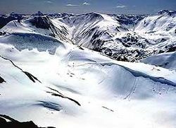
The Coast Mountains are approximately 1600 kilometres (994.2 mi) long and average 300 kilometres (186.4 mi) in width. Its southern and southeastern boundaries are surrounded by the Fraser River
and the Interior Plateau
while its far northwestern edge is delimited by the Kelsall
and Tatshenshini River
s at the north end of the Alaska Panhandle, beyond which are the Saint Elias Mountains, and by Champagne Pass
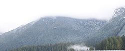
in the Yukon Territory. Covered in dense temperate rainforest on its western exposures, the range rises to heavily glaciated
peaks, including the largest temperate-latitude icefields in the world. It then tapers to the dry Interior Plateau on its eastern flanks, or to the subarctic boreal forest of the Skeena Mountains
and Stikine Plateau
.
The Coast Mountains are part of the Pacific Ring of Fire
, the ring of volcanoes and associated mountains around the Pacific Ocean
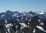
. It contains some of British Columbia's highest mountains. Mount Waddington
, northeast of the head of Knight Inlet
with an elevation of 4019 metres (13,185.7 ft), is the highest mountain of the Coast Mountains and the highest that lies entirely within British Columbia.
, the Kitimat Ranges
, and the Boundary Ranges
. The Pacific Ranges are the southernmost subdivision of the Coast Mountains, extending from the lower stretches of the Fraser River
to Bella Coola
. Included in this subdivision is four of the five major coastal icecaps in the southern Coast Mountains. These are the largest temperate-latitude icecaps in the world and fuel a number of major river
s. Other than logging and a large ski resort at the resort town
of Whistler
, most of the land in the range is completely undeveloped. Mount Waddington
, the highest mountain of the Coast Mountains, lies in the Waddington Range
of the Pacific Ranges.
Just north of the Pacific Ranges lies the central subdivision known as the Kitimat Ranges. This subdivision extends from the Bella Coola River
and Burke Channel
in the south to the Nass River
in the north.
The third and northernmost subdivision of the Coast Mountains is the Boundary Ranges
, extending from the Nass River in the south to the Kelsall River
in the north. It is also the largest subdivision of the Coast Mountains, spanning the British Columbia-Alaska border and northwards into Yukon
flanking the west side of the Yukon River
drainage as far as Champagne Pass, north of which being the Yukon Ranges
. The Boundary Ranges include several large icefields, including the Juneau Icefield
between Juneau, Alaska
and Atlin Lake
in British Columbia, and the Stikine Icecap
, which lies between the lower Stikine River
and the Whiting River
.
Because the Coast Mountains are just east of the Pacific Ocean
, they have a profound effect on British Columbia's climate by forcing moisture-laden air off the Pacific Ocean to rise, dropping heavy rainfalls on the western slopes where lush forests exist. This precipitation is among the heaviest in North America. The eastern slopes are relatively dry and less steep and protect the British Columbia Interior
from the Pacific weather systems, resulting in dry warm summers and dry cold winters.
Beyond the eastern slopes is a 154635 square kilometre plateau occupying the southern and central portions of British Columbia called the Interior Plateau
. Included within the Interior Plateau is a coalescing series of layered flood basalt
lava flows. These sequences of fluid volcanic rock
cover about 25000 square kilometre of the Interior Plateau and have a volume of about 1800 km³ (431.8 cu mi), forming a large volcanic plateau
constructed atop of the Interior Plateau. North of the Interior Plateau on the range's northeastern slopes lies a huge mountainous area known by geographers as the Interior Mountains
, which includes the neighbouring Skeena
, Cassiar
and Hazelton Mountains
.
and metamorphosed
structurally complex pre-Tertiary
rocks. These originated in diverse locations around the globe: the area is built of several different terrane
s of different ages with a broad range of tectonic origins. In addition, oceanic crust
under the Pacific Ocean
is being subducted
at the southern portion of the range to form a north-south line of volcanoes called the Garibaldi Volcanic Belt
, a northern extension of the Cascade Volcanoes
in the northwestern United States
, and contains the most explosive young volcanoes in Canada. Further north the northwesterly structural trend of the Coast Mountains lies partly in a large continental rift
responsible for the creation of several volcanoes. These volcanoes form part of the Northern Cordilleran Volcanic Province
, the most volcanically active area in Canada.
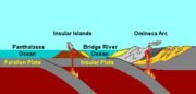
The first event began 130 million years ago when a group of active volcanic islands approached a pre-existing continental margin
and coastline of North America. These volcanic islands, known as the Insular Islands
by geoscientists, were formed on a pre-existing tectonic plate
called the Insular Plate
by subduction
of the former Farallon Plate
to the west during the early Paleozoic
era. This subduction zone records another subduction zone to the east under an ancient ocean basin between the Insular Islands and the former continental margin of North America called the Bridge River Ocean
. This arrangement of two parallel subduction zones is unusual in that very few twin subduction zones exist on Earth; the Philippine Mobile Belt
off the southeastern coast of Asia
is an example of a modern twin subduction zone. As the Insular Plate drew closer to the pre-existing continental margin by ongoing subduction under the Bridge River Ocean, the Insular Islands drew closer to the former continental margin and coastline of western North America, supporting a pre-existing volcanic arc on the former continental margin of North America called the Omineca Arc
. As the North American Plate
drifted west and the Insular Plate drifted east to the old continental margin of western North America, the Bridge River Ocean eventually closed by ongoing subduction under the Bridge River Ocean. This subduction zone eventually jammed and shut down completely 115 million years ago, ending the Omineca Arc and the Insular Islands collided, forming the Insular Belt
. Compression resulting from this collision crushed, fractured and folded
rocks along the old continental margin. The Insular Belt then welded onto the pre-existing continental margin by magma that eventually cooled to create a large mass of igneous rock
, creating a new continental margin. This large mass of igneous rock is the largest granite
outcropping in North America.

continued to subduct under the new continental margin after the Insular Plate and Insular Islands collided with the old continental margin, supporting a new continental volcanic arc called the Coast Range Arc
about 100 million years ago during the Late Cretaceous
period. Magma ascending from the Farallon Plate under the new continental margin burned their way upward through the newly accreted Insular Belt, injecting huge quantities of granite into older igneous rocks of the Insular Belt. At the surface, new volcanoes were built along the continental margin. Named after the Coast Mountains, the basement of this arc was likely Early Cretaceous and Late Jurassic
intrusions from the Insular Islands.
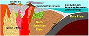 One of the major aspects that changed early during the Coast Range Arc was the status of the northern end of the Farallon Plate, a portion now known as the Kula Plate
. About 85 million years ago, the Kula Plate broke off from the Farallon Plate to form a mid-ocean ridge
known to geoscientists as the Kula-Farallon Ridge. This change apparently had some important ramifications for regional geologic evolution. When this change was completed, Coast Range Arc volcanism returned and sections of the arc were uplifted considerably in latest Cretaceous time. This started a period of mountain building that affected much of western North America called the Laramide orogeny
. In particular a large area of dextral transpression and southwest-directed thrust faulting was active from 75 to 65 million years ago. Much of the record of this deformation has been overridden by Tertiary
age structures and the zone of Cretaceous dextral thrust faulting appears to have been widespread. It was also during this period when massive amounts of molten granite intruded highly deformed ocean rocks and assorted fragments from pre-existing island arcs, largely remnants of the Bridge River Ocean. This molten granite burned the old oceanic sediments into a glittering medium-grade metamorphic rock
called schist
. The older intrusions of the Coast Range Arc were then deformed under the heat and pressure of later intrusions, turning them into layered metamorphic rock known as gneiss
. In some places, mixtures of older intrusive rocks and the original oceanic rocks have been distorted and warped under intense heat, weight and stress to create unusual swirled patters known as migmatite
, appearing to have been nearly melted in the procedure.
Volcanism began to decline along the length of the arc about 60 million years ago during the Albian
and Aptian
faunal stage
s of the Cretaceous period. This resulted from the changing geometry of the Kula Plate, which progressively developed a more northerly movement along the Pacific Northwest
. Instead of subducting beneath the Pacific Northwest, the Kula Plate began subducting underneath southwestern Yukon and Alaska and during the early Eocene
period. Volcanism along the entire length of the Coast Range Arc shut down about 50 million years ago and many of the volcanoes have disappeared from erosion. What remains of the Coast Range Arc to this day are outcrops of granite when magma intruded and cooled at depth beneath the volcanoes, forming the present Coast Mountains. During construction of intrusions 70 and 57 million years ago, the northern motion of the Kula Plate might have been between 140 mm (6 in) and 110 mm (4 in) per year. However, other geologic studies determined the Kula Plate moved at a rate as fast as 200 mm (8 in) per year.
Mountain range
A mountain range is a single, large mass consisting of a succession of mountains or narrowly spaced mountain ridges, with or without peaks, closely related in position, direction, formation, and age; a component part of a mountain system or of a mountain chain...
, in the Pacific Coast Ranges
Pacific Coast Ranges
The Pacific Coast Ranges and the Pacific Mountain System are the series of mountain ranges that stretch along the West Coast of North America from Alaska south to Northern and Central Mexico...
, of western North America
North America
North America is a continent wholly within the Northern Hemisphere and almost wholly within the Western Hemisphere. It is also considered a northern subcontinent of the Americas...
, extending from southwestern Yukon
Yukon
Yukon is the westernmost and smallest of Canada's three federal territories. It was named after the Yukon River. The word Yukon means "Great River" in Gwich’in....
through the Alaska Panhandle
Alaska Panhandle
Southeast Alaska, sometimes referred to as the Alaska Panhandle, is the southeastern portion of the U.S. state of Alaska, which lies west of the northern half of the Canadian province of British Columbia. The majority of Southeast Alaska's area is part of the Tongass National Forest, the United...
and virtually all of the Coast of British Columbia
British Columbia Coast
The British Columbia Coast or BC Coast is Canada's western continental coastline on the Pacific Ocean. The usage is synonymous with the term West Coast of Canada....
. They are so-named because of their proximity to the sea coast, and are often referred to as the Coast Range. It includes volcanic and non-volcanic mountains and the huge icefields of the Pacific
Pacific Ranges
The Pacific Ranges are the southernmost subdivision of the Coast Mountains portion of the Pacific Cordillera. Located entirely within British Columbia, Canada, they run northwest from the lower stretches of the Fraser River to Bella Coola, north of which are the Kitimat Ranges.The Pacific Ranges...
and Boundary Ranges
Boundary Ranges
The Boundary Ranges, also known in the singular and as the Alaska Boundary Range, are the largest and most northerly subrange of the Coast Mountains...
, and the northern end of the notable volcanic
Volcano
2. Bedrock3. Conduit 4. Base5. Sill6. Dike7. Layers of ash emitted by the volcano8. Flank| 9. Layers of lava emitted by the volcano10. Throat11. Parasitic cone12. Lava flow13. Vent14. Crater15...
system known as the Cascade Volcanoes
Cascade Volcanoes
The Cascade Volcanoes are a number of volcanoes in a volcanic arc in western North America, extending from southwestern British Columbia through Washington and Oregon to Northern California, a distance of well over 700 mi ...
. The Coast Mountains are part of a larger mountain system called the Pacific Coast Ranges
Pacific Coast Ranges
The Pacific Coast Ranges and the Pacific Mountain System are the series of mountain ranges that stretch along the West Coast of North America from Alaska south to Northern and Central Mexico...
or the Pacific Mountain System, which includes the Cascade Range
Cascade Range
The Cascade Range is a major mountain range of western North America, extending from southern British Columbia through Washington and Oregon to Northern California. It includes both non-volcanic mountains, such as the North Cascades, and the notable volcanoes known as the High Cascades...
, the Insular Mountains
Insular Mountains
The Insular Mountains are a range of mountains in the Pacific Coast Ranges on the coast of British Columbia, Canada, comprising the Vancouver Island Ranges and Queen Charlotte Mountains. The Insular Mountains are rugged, particularly on Vancouver Island where peaks in Strathcona Provincial Park...
, the Oregon
Oregon Coast Range
The Oregon Coast Range, often called simply the Coast Range and sometimes the Pacific Coast Range, is a mountain range, in the Pacific Coast Ranges physiographic region, in the U.S. state of Oregon along the Pacific Ocean...
and California Coast Ranges and the Saint Elias
Saint Elias Mountains
The Saint Elias Mountains are a subgroup of the Pacific Coast Ranges, located in southeastern Alaska in the United States, southwestern Yukon and the very far northwestern part of British Columbia in Canada. The range spans Wrangell-St. Elias National Park and Preserve in the USA and Kluane...
and Chugach Mountains
Chugach Mountains
The Chugach Mountains of southern Alaska are the northernmost of the several mountain ranges that make up the Pacific Coast Ranges of the western edge of North America. The range is about 500 km long, running generally east-west. Its highest point is Mount Marcus Baker, at , but most of its...
.
The Coast Mountains are approximately 1600 kilometres (994.2 mi) long and average 300 kilometres (186.4 mi) in width. Its southern and southeastern boundaries are surrounded by the Fraser River
Fraser River
The Fraser River is the longest river within British Columbia, Canada, rising at Fraser Pass near Mount Robson in the Rocky Mountains and flowing for , into the Strait of Georgia at the city of Vancouver. It is the tenth longest river in Canada...
and the Interior Plateau
Interior Plateau
The Interior Plateau comprises a large region of central British Columbia, and lies between the Cariboo and Monashee Mountains on the east, and the Hazelton Mountains, Coast Mountains and Cascade Range on the west. The continuation of the plateau into the United States is known there as the...
while its far northwestern edge is delimited by the Kelsall
Kelsall River
The Kelsall River is a river in the U.S. State of Alaska, the Canadian province of British Columbia, and Yukon Territory. It is a tributary of the Chilkat River, flowing into it in the Haines Borough of Alaska.-See also:*List of rivers of Alaska...
and Tatshenshini River
Tatshenshini River
The Tatshenshini River is a river in the southwestern Yukon and the northwestern corner of British Columbia. It originates in British Columbia, near Haines Highway...
s at the north end of the Alaska Panhandle, beyond which are the Saint Elias Mountains, and by Champagne Pass
Champagne, Yukon
Champagne Landing is a small Indian settlement on the Alaska Highway in Canada's Yukon. The few residents are citizens of the Champagne and Aishihik First Nations. The resident population was 24 in the Canada 2006 Census.Champagne is on the Dezadeash River, one of the tributaries of the Alsek...
in the Yukon Territory. Covered in dense temperate rainforest on its western exposures, the range rises to heavily glaciated
Glacier
A glacier is a large persistent body of ice that forms where the accumulation of snow exceeds its ablation over many years, often centuries. At least 0.1 km² in area and 50 m thick, but often much larger, a glacier slowly deforms and flows due to stresses induced by its weight...
peaks, including the largest temperate-latitude icefields in the world. It then tapers to the dry Interior Plateau on its eastern flanks, or to the subarctic boreal forest of the Skeena Mountains
Skeena Mountains
The Skeena Mountains, also known as the Skeenas, are a subrange of the Interior Mountains of northern British Columbia, Canada, essentially flanking the upper basin of the Skeena River. They lie just inland from the southern end of the Boundary Ranges of the Coast Mountains, and also of the...
and Stikine Plateau
Stikine Plateau
The Stikine Plateau is a plateau in northern British Columbia, Canada. It lies between the Boundary Ranges of the Coast Mountains on the west and southwest and the Cassiar Mountains along its northeast, and between the Skeena Mountains on its south and southeast and the Jennings and Nakina Rivers...
.
The Coast Mountains are part of the Pacific Ring of Fire
Pacific Ring of Fire
The Pacific Ring of Fire is an area where large numbers of earthquakes and volcanic eruptions occur in the basin of the Pacific Ocean. In a horseshoe shape, it is associated with a nearly continuous series of oceanic trenches, volcanic arcs, and volcanic belts and/or plate movements...
, the ring of volcanoes and associated mountains around the Pacific Ocean
Pacific Ocean
The Pacific Ocean is the largest of the Earth's oceanic divisions. It extends from the Arctic in the north to the Southern Ocean in the south, bounded by Asia and Australia in the west, and the Americas in the east.At 165.2 million square kilometres in area, this largest division of the World...
. It contains some of British Columbia's highest mountains. Mount Waddington
Mount Waddington
Mount Waddington, once known as Mystery Mountain, is the highest peak in the Coast Mountains of British Columbia, Canada. Although Mount Fairweather and Mount Quincy Adams, which straddle the US border between Alaska and British Columbia are taller, Mount Waddington is the highest peak that lies...
, northeast of the head of Knight Inlet
Knight Inlet
Knight Inlet is one of the principal inlets of the British Columbia Coast, and the largest of the major inlets in the southern part of the Coast...
with an elevation of 4019 metres (13,185.7 ft), is the highest mountain of the Coast Mountains and the highest that lies entirely within British Columbia.
Geography
The Coast Mountains consists of three subdivisions known as the Pacific RangesPacific Ranges
The Pacific Ranges are the southernmost subdivision of the Coast Mountains portion of the Pacific Cordillera. Located entirely within British Columbia, Canada, they run northwest from the lower stretches of the Fraser River to Bella Coola, north of which are the Kitimat Ranges.The Pacific Ranges...
, the Kitimat Ranges
Kitimat Ranges
The Kitimat Ranges are one of the three main subdivisions of the Coast Mountains in British Columbia, Canada, the other being the Pacific Ranges to the south and the Boundary Ranges to the north...
, and the Boundary Ranges
Boundary Ranges
The Boundary Ranges, also known in the singular and as the Alaska Boundary Range, are the largest and most northerly subrange of the Coast Mountains...
. The Pacific Ranges are the southernmost subdivision of the Coast Mountains, extending from the lower stretches of the Fraser River
Fraser River
The Fraser River is the longest river within British Columbia, Canada, rising at Fraser Pass near Mount Robson in the Rocky Mountains and flowing for , into the Strait of Georgia at the city of Vancouver. It is the tenth longest river in Canada...
to Bella Coola
Bella Coola, British Columbia
Bella Coola is a community of approximately 600 at the western extremity of the Bella Coola Valley. Bella Coola usually refers to the entire valley, encompassing the settlements of Bella Coola proper , Lower Bella Coola, Hagensborg, Saloompt, Nusatsum, Firvale and Stuie...
. Included in this subdivision is four of the five major coastal icecaps in the southern Coast Mountains. These are the largest temperate-latitude icecaps in the world and fuel a number of major river
River
A river is a natural watercourse, usually freshwater, flowing towards an ocean, a lake, a sea, or another river. In a few cases, a river simply flows into the ground or dries up completely before reaching another body of water. Small rivers may also be called by several other names, including...
s. Other than logging and a large ski resort at the resort town
Resort town
A resort town, sometimes called a resort city or resort destination, is a town or area where tourism or vacationing is a primary component of the local culture and economy...
of Whistler
Whistler, British Columbia
Whistler is a Canadian resort town in the southern Pacific Ranges of the Coast Mountains in the province of British Columbia, Canada, approximately north of Vancouver...
, most of the land in the range is completely undeveloped. Mount Waddington
Mount Waddington
Mount Waddington, once known as Mystery Mountain, is the highest peak in the Coast Mountains of British Columbia, Canada. Although Mount Fairweather and Mount Quincy Adams, which straddle the US border between Alaska and British Columbia are taller, Mount Waddington is the highest peak that lies...
, the highest mountain of the Coast Mountains, lies in the Waddington Range
Waddington Range
The Waddington Range is a subrange of the Pacific Ranges of the Coast Mountains in southwestern British Columbia, Canada. It is only about 4000 km² in area, relatively small in area within the expanse of the range, but it is the highest area of the Pacific Ranges and of the Coast Mountains, being...
of the Pacific Ranges.
Just north of the Pacific Ranges lies the central subdivision known as the Kitimat Ranges. This subdivision extends from the Bella Coola River
Bella Coola River
The Bella Coola River is a major river on the Pacific slope of the Coast Mountains in southern British Columbia. The town of Bella Coola, which is the historic and ancient capital of the Nuxalk people, is at its mouth on North Bentinck Arm...
and Burke Channel
Burke Channel
Burke Channel is a channel in the Central Coast region of the Canadian province of British Columbia, separating the south and east coasts of King Island from the mainland. It was first charted in 1792 by James Johnstone, one of George Vancouver’s officers during his 1791-95 expedition. Vancouver...
in the south to the Nass River
Nass River
The Nass River is a river in northern British Columbia, Canada. It flows from the Coast Mountains southwest to Nass Bay, a sidewater of Portland Inlet, which connects to the North Pacific Ocean via the Dixon Entrance...
in the north.
The third and northernmost subdivision of the Coast Mountains is the Boundary Ranges
Boundary Ranges
The Boundary Ranges, also known in the singular and as the Alaska Boundary Range, are the largest and most northerly subrange of the Coast Mountains...
, extending from the Nass River in the south to the Kelsall River
Kelsall River
The Kelsall River is a river in the U.S. State of Alaska, the Canadian province of British Columbia, and Yukon Territory. It is a tributary of the Chilkat River, flowing into it in the Haines Borough of Alaska.-See also:*List of rivers of Alaska...
in the north. It is also the largest subdivision of the Coast Mountains, spanning the British Columbia-Alaska border and northwards into Yukon
Yukon
Yukon is the westernmost and smallest of Canada's three federal territories. It was named after the Yukon River. The word Yukon means "Great River" in Gwich’in....
flanking the west side of the Yukon River
Yukon River
The Yukon River is a major watercourse of northwestern North America. The source of the river is located in British Columbia, Canada. The next portion lies in, and gives its name to Yukon Territory. The lower half of the river lies in the U.S. state of Alaska. The river is long and empties into...
drainage as far as Champagne Pass, north of which being the Yukon Ranges
Yukon Ranges
The Yukon Ranges are a mountain range comprising the mountains in the southeastern part of the U.S. state of Alaska and most of the Yukon, Canada...
. The Boundary Ranges include several large icefields, including the Juneau Icefield
Juneau Icefield
The Juneau Icefield is an ice field located just north of Juneau, Alaska and continues north through the border with British Columbia and is the fifth-largest ice field in the Western Hemisphere, extending through an area of in the Coast Range ranging north to south and east to west. The...
between Juneau, Alaska
Juneau, Alaska
The City and Borough of Juneau is a unified municipality located on the Gastineau Channel in the panhandle of the U.S. state of Alaska. It has been the capital of Alaska since 1906, when the government of the then-District of Alaska was moved from Sitka as dictated by the U.S. Congress in 1900...
and Atlin Lake
Atlin Lake
Atlin Lake is a lake in northwestern British Columbia and is that province's largest natural lake. The northern tip of the lake is in the Yukon, as is Little Atlin Lake. However, most of the lake lies within the Atlin District of British Columbia...
in British Columbia, and the Stikine Icecap
Stikine Icecap
The Stikine Icecap is a large icefield straddled on the Alaska–British Columbia boundary in the Alaska Panhandle region. It lies in the Boundary Ranges of the Coast Mountains...
, which lies between the lower Stikine River
Stikine River
The Stikine River is a river, historically also the Stickeen River, approximately 610 km long, in northwestern British Columbia in Canada and southeastern Alaska in the United States...
and the Whiting River
Whiting River
The Whiting River is a river in Alaska and British Columbia, entering the waters of Stephens Passage at the Borough of Juneau in the Alaska Panhandle between the mouths of the Taku and Stikine Rivers. The main tributary of the Whiting is the South Whiting. The river's basin is at the northern end...
.
Because the Coast Mountains are just east of the Pacific Ocean
Pacific Ocean
The Pacific Ocean is the largest of the Earth's oceanic divisions. It extends from the Arctic in the north to the Southern Ocean in the south, bounded by Asia and Australia in the west, and the Americas in the east.At 165.2 million square kilometres in area, this largest division of the World...
, they have a profound effect on British Columbia's climate by forcing moisture-laden air off the Pacific Ocean to rise, dropping heavy rainfalls on the western slopes where lush forests exist. This precipitation is among the heaviest in North America. The eastern slopes are relatively dry and less steep and protect the British Columbia Interior
British Columbia Interior
The British Columbia Interior or BC Interior or Interior of British Columbia, usually referred to only as the Interior, is one of the three main regions of the Canadian province of British Columbia, the other two being the Lower Mainland, which comprises the overlapping areas of Greater Vancouver...
from the Pacific weather systems, resulting in dry warm summers and dry cold winters.
Beyond the eastern slopes is a 154635 square kilometre plateau occupying the southern and central portions of British Columbia called the Interior Plateau
Interior Plateau
The Interior Plateau comprises a large region of central British Columbia, and lies between the Cariboo and Monashee Mountains on the east, and the Hazelton Mountains, Coast Mountains and Cascade Range on the west. The continuation of the plateau into the United States is known there as the...
. Included within the Interior Plateau is a coalescing series of layered flood basalt
Flood basalt
A flood basalt or trap basalt is the result of a giant volcanic eruption or series of eruptions that coats large stretches of land or the ocean floor with basalt lava. Flood basalts have occurred on continental scales in prehistory, creating great plateaus and mountain ranges...
lava flows. These sequences of fluid volcanic rock
Volcanic rock
Volcanic rock is a rock formed from magma erupted from a volcano. In other words, it is an igneous rock of volcanic origin...
cover about 25000 square kilometre of the Interior Plateau and have a volume of about 1800 km³ (431.8 cu mi), forming a large volcanic plateau
Volcanic plateau
A volcanic plateau is a plateau produced by volcanic activity. There are two main types: lava plateaus and pyroclastic plateaus.-Lava plateau:...
constructed atop of the Interior Plateau. North of the Interior Plateau on the range's northeastern slopes lies a huge mountainous area known by geographers as the Interior Mountains
Interior Mountains
The Interior Mountains, also called the Northern Interior Mountains and Interior Ranges, are the semi-official names for a huge area that comprises much of the northern two thirds of the Canadian province of British Columbia and a large area of southern Yukon...
, which includes the neighbouring Skeena
Skeena Mountains
The Skeena Mountains, also known as the Skeenas, are a subrange of the Interior Mountains of northern British Columbia, Canada, essentially flanking the upper basin of the Skeena River. They lie just inland from the southern end of the Boundary Ranges of the Coast Mountains, and also of the...
, Cassiar
Cassiar Mountains
The Cassiar Mountains are the most northerly group of the Northern Interior Mountains in the Canadian province of British Columbia and the Yukon Territory. They lie north and west of the Omineca Mountains, west of the northernmost Rockies and the Rocky Mountain Trench, north of the Hazelton...
and Hazelton Mountains
Hazelton Mountains
The Hazelton Mountains are a grouping of mountain ranges on the inland lee of the Kitimat Ranges of the Coast Mountains in northwestern British Columbia, Canada, spanning the area of Hazelton, British Columbia south to the Nechako Reservoir...
.
Origins and growth
The Coast Mountains consists of deformed igneousIgneous rock
Igneous rock is one of the three main rock types, the others being sedimentary and metamorphic rock. Igneous rock is formed through the cooling and solidification of magma or lava...
and metamorphosed
Metamorphic rock
Metamorphic rock is the transformation of an existing rock type, the protolith, in a process called metamorphism, which means "change in form". The protolith is subjected to heat and pressure causing profound physical and/or chemical change...
structurally complex pre-Tertiary
Tertiary
The Tertiary is a deprecated term for a geologic period 65 million to 2.6 million years ago. The Tertiary covered the time span between the superseded Secondary period and the Quaternary...
rocks. These originated in diverse locations around the globe: the area is built of several different terrane
Terrane
A terrane in geology is short-hand term for a tectonostratigraphic terrane, which is a fragment of crustal material formed on, or broken off from, one tectonic plate and accreted or "sutured" to crust lying on another plate...
s of different ages with a broad range of tectonic origins. In addition, oceanic crust
Oceanic crust
Oceanic crust is the part of Earth's lithosphere that surfaces in the ocean basins. Oceanic crust is primarily composed of mafic rocks, or sima, which is rich in iron and magnesium...
under the Pacific Ocean
Pacific Ocean
The Pacific Ocean is the largest of the Earth's oceanic divisions. It extends from the Arctic in the north to the Southern Ocean in the south, bounded by Asia and Australia in the west, and the Americas in the east.At 165.2 million square kilometres in area, this largest division of the World...
is being subducted
Subduction
In geology, subduction is the process that takes place at convergent boundaries by which one tectonic plate moves under another tectonic plate, sinking into the Earth's mantle, as the plates converge. These 3D regions of mantle downwellings are known as "Subduction Zones"...
at the southern portion of the range to form a north-south line of volcanoes called the Garibaldi Volcanic Belt
Garibaldi Volcanic Belt
The Garibaldi Volcanic Belt, also called the Canadian Cascade Arc, is a northwest-southeast trending volcanic chain in the Pacific Ranges of the Coast Mountains that extends from Watts Point in the south to the Ha-Iltzuk Icefield in the north. This chain of volcanoes is located in southwestern...
, a northern extension of the Cascade Volcanoes
Cascade Volcanoes
The Cascade Volcanoes are a number of volcanoes in a volcanic arc in western North America, extending from southwestern British Columbia through Washington and Oregon to Northern California, a distance of well over 700 mi ...
in the northwestern United States
United States
The United States of America is a federal constitutional republic comprising fifty states and a federal district...
, and contains the most explosive young volcanoes in Canada. Further north the northwesterly structural trend of the Coast Mountains lies partly in a large continental rift
Rift
In geology, a rift or chasm is a place where the Earth's crust and lithosphere are being pulled apart and is an example of extensional tectonics....
responsible for the creation of several volcanoes. These volcanoes form part of the Northern Cordilleran Volcanic Province
Northern Cordilleran volcanic province
The Northern Cordilleran Volcanic Province , formerly known as the Stikine Volcanic Belt, is a geologic province defined by the occurrence of Miocene to Holocene volcanoes in the Pacific Northwest of North America...
, the most volcanically active area in Canada.
Insular and Omineca Arc eruptive periods
The first event began 130 million years ago when a group of active volcanic islands approached a pre-existing continental margin
Continental margin
The continental margin is the zone of the ocean floor that separates the thin oceanic crust from thick continental crust. Continental margins constitute about 28% of the oceanic area....
and coastline of North America. These volcanic islands, known as the Insular Islands
Insular Islands
The Insular Islands were a giant chain of active volcanic islands somewhere in the Pacific Ocean during the Cretaceous time that rode on top a microplate called the Insular Plate, beginning around 130 million years ago. The Insular Islands were surrounded by two prehistoric oceans; the Panthalassa...
by geoscientists, were formed on a pre-existing tectonic plate
Plate tectonics
Plate tectonics is a scientific theory that describes the large scale motions of Earth's lithosphere...
called the Insular Plate
Insular Plate
The Insular Plate was an ancient oceanic plate that began subducting under the west-coast of North America around the early Cretaceous time. The Insular Plate had a chain of active volcanic islands that were called the Insular Islands...
by subduction
Subduction
In geology, subduction is the process that takes place at convergent boundaries by which one tectonic plate moves under another tectonic plate, sinking into the Earth's mantle, as the plates converge. These 3D regions of mantle downwellings are known as "Subduction Zones"...
of the former Farallon Plate
Farallon Plate
The Farallon Plate was an ancient oceanic plate, which began subducting under the west coast of the North American Plate— then located in modern Utah— as Pangaea broke apart during the Jurassic Period...
to the west during the early Paleozoic
Paleozoic
The Paleozoic era is the earliest of three geologic eras of the Phanerozoic eon, spanning from roughly...
era. This subduction zone records another subduction zone to the east under an ancient ocean basin between the Insular Islands and the former continental margin of North America called the Bridge River Ocean
Bridge River Ocean
The Bridge River Ocean was an ancient ocean that existed between North America and the Insular Islands during the Paleozoic time. Like the earlier Slide Mountain Ocean the Bridge River Ocean had a subduction zone on the ocean floor called the Insular Trench...
. This arrangement of two parallel subduction zones is unusual in that very few twin subduction zones exist on Earth; the Philippine Mobile Belt
Philippine Mobile Belt
The Philippine Mobile Belt is a complex portion of the tectonic boundary between the Eurasian Plate and the Philippine Sea Plate, comprising most of the country of the Philippines. It includes two subduction zones, the Manila Trench to the west and the Philippine Trench to the east, as well as the...
off the southeastern coast of Asia
Asia
Asia is the world's largest and most populous continent, located primarily in the eastern and northern hemispheres. It covers 8.7% of the Earth's total surface area and with approximately 3.879 billion people, it hosts 60% of the world's current human population...
is an example of a modern twin subduction zone. As the Insular Plate drew closer to the pre-existing continental margin by ongoing subduction under the Bridge River Ocean, the Insular Islands drew closer to the former continental margin and coastline of western North America, supporting a pre-existing volcanic arc on the former continental margin of North America called the Omineca Arc
Omineca Arc
The Omineca Arc or Omineca Belt was a Jurassic through Cretaceous volcanic arc terrane in western North America, extending from Alaska through Yukon and British Columbia to Washington. The Omeneca is bounded by the Foreland Belt to the east and the Intermontane Belt to the west...
. As the North American Plate
North American Plate
The North American Plate is a tectonic plate covering most of North America, Greenland, Cuba, Bahamas, and parts of Siberia, Japan and Iceland. It extends eastward to the Mid-Atlantic Ridge and westward to the Chersky Range in eastern Siberia. The plate includes both continental and oceanic crust...
drifted west and the Insular Plate drifted east to the old continental margin of western North America, the Bridge River Ocean eventually closed by ongoing subduction under the Bridge River Ocean. This subduction zone eventually jammed and shut down completely 115 million years ago, ending the Omineca Arc and the Insular Islands collided, forming the Insular Belt
Insular Belt
The Insular Belt is a physiogeological region on the north western North American coast. It consist of three major island groups and many smaller islands and stretches from southern British Columbia into Alaska and the Yukon...
. Compression resulting from this collision crushed, fractured and folded
Fold (geology)
The term fold is used in geology when one or a stack of originally flat and planar surfaces, such as sedimentary strata, are bent or curved as a result of permanent deformation. Synsedimentary folds are those due to slumping of sedimentary material before it is lithified. Folds in rocks vary in...
rocks along the old continental margin. The Insular Belt then welded onto the pre-existing continental margin by magma that eventually cooled to create a large mass of igneous rock
Igneous rock
Igneous rock is one of the three main rock types, the others being sedimentary and metamorphic rock. Igneous rock is formed through the cooling and solidification of magma or lava...
, creating a new continental margin. This large mass of igneous rock is the largest granite
Granite
Granite is a common and widely occurring type of intrusive, felsic, igneous rock. Granite usually has a medium- to coarse-grained texture. Occasionally some individual crystals are larger than the groundmass, in which case the texture is known as porphyritic. A granitic rock with a porphyritic...
outcropping in North America.
Coast Range Arc eruptive period
The final event began when the Farallon PlateFarallon Plate
The Farallon Plate was an ancient oceanic plate, which began subducting under the west coast of the North American Plate— then located in modern Utah— as Pangaea broke apart during the Jurassic Period...
continued to subduct under the new continental margin after the Insular Plate and Insular Islands collided with the old continental margin, supporting a new continental volcanic arc called the Coast Range Arc
Coast Range Arc
The Coast Range Arc was a large volcanic arc system, extending from northern Washington through British Columbia and the Alaska Panhandle to southwestern Yukon. The Coast Range Arc lies along the western margin of the North American Plate in the Pacific Northwest of western North America...
about 100 million years ago during the Late Cretaceous
Late Cretaceous
The Late Cretaceous is the younger of two epochs into which the Cretaceous period is divided in the geologic timescale. Rock strata from this epoch form the Upper Cretaceous series...
period. Magma ascending from the Farallon Plate under the new continental margin burned their way upward through the newly accreted Insular Belt, injecting huge quantities of granite into older igneous rocks of the Insular Belt. At the surface, new volcanoes were built along the continental margin. Named after the Coast Mountains, the basement of this arc was likely Early Cretaceous and Late Jurassic
Late Jurassic
The Late Jurassic is the third epoch of the Jurassic Period, and it spans the geologic time from 161.2 ± 4.0 to 145.5 ± 4.0 million years ago , which is preserved in Upper Jurassic strata. In European lithostratigraphy, the name "Malm" indicates rocks of Late Jurassic age...
intrusions from the Insular Islands.
Kula Plate
The Kula Plate is an oceanic tectonic plate under the northern Pacific Ocean south of the Near Islands segment of the Aleutian Islands. It is subducting under the North American Plate at the Aleutian Trench and is surrounded by the Pacific Plate...
. About 85 million years ago, the Kula Plate broke off from the Farallon Plate to form a mid-ocean ridge
Mid-ocean ridge
A mid-ocean ridge is a general term for an underwater mountain system that consists of various mountain ranges , typically having a valley known as a rift running along its spine, formed by plate tectonics. This type of oceanic ridge is characteristic of what is known as an oceanic spreading...
known to geoscientists as the Kula-Farallon Ridge. This change apparently had some important ramifications for regional geologic evolution. When this change was completed, Coast Range Arc volcanism returned and sections of the arc were uplifted considerably in latest Cretaceous time. This started a period of mountain building that affected much of western North America called the Laramide orogeny
Laramide orogeny
The Laramide orogeny was a period of mountain building in western North America, which started in the Late Cretaceous, 70 to 80 million years ago, and ended 35 to 55 million years ago. The exact duration and ages of beginning and end of the orogeny are in dispute, as is the cause. The Laramide...
. In particular a large area of dextral transpression and southwest-directed thrust faulting was active from 75 to 65 million years ago. Much of the record of this deformation has been overridden by Tertiary
Tertiary
The Tertiary is a deprecated term for a geologic period 65 million to 2.6 million years ago. The Tertiary covered the time span between the superseded Secondary period and the Quaternary...
age structures and the zone of Cretaceous dextral thrust faulting appears to have been widespread. It was also during this period when massive amounts of molten granite intruded highly deformed ocean rocks and assorted fragments from pre-existing island arcs, largely remnants of the Bridge River Ocean. This molten granite burned the old oceanic sediments into a glittering medium-grade metamorphic rock
Metamorphic rock
Metamorphic rock is the transformation of an existing rock type, the protolith, in a process called metamorphism, which means "change in form". The protolith is subjected to heat and pressure causing profound physical and/or chemical change...
called schist
Schist
The schists constitute a group of medium-grade metamorphic rocks, chiefly notable for the preponderance of lamellar minerals such as micas, chlorite, talc, hornblende, graphite, and others. Quartz often occurs in drawn-out grains to such an extent that a particular form called quartz schist is...
. The older intrusions of the Coast Range Arc were then deformed under the heat and pressure of later intrusions, turning them into layered metamorphic rock known as gneiss
Gneiss
Gneiss is a common and widely distributed type of rock formed by high-grade regional metamorphic processes from pre-existing formations that were originally either igneous or sedimentary rocks.-Etymology:...
. In some places, mixtures of older intrusive rocks and the original oceanic rocks have been distorted and warped under intense heat, weight and stress to create unusual swirled patters known as migmatite
Migmatite
Migmatite is a rock at the frontier between igneous and metamorphic rocks. They can also be known as diatexite.Migmatites form under extreme temperature conditions during prograde metamorphism, where partial melting occurs in pre-existing rocks. Migmatites are not crystallized from a totally...
, appearing to have been nearly melted in the procedure.
Volcanism began to decline along the length of the arc about 60 million years ago during the Albian
Albian
The Albian is both an age of the geologic timescale and a stage in the stratigraphic column. It is the youngest or uppermost subdivision of the Early/Lower Cretaceous epoch/series. Its approximate time range is 112.0 ± 1.0 Ma to 99.6 ± 0.9 Ma...
and Aptian
Aptian
The Aptian is an age in the geologic timescale or a stage in the stratigraphic column. It is a subdivision of the Early or Lower Cretaceous epoch or series and encompasses the time from 125.0 ± 1.0 Ma to 112.0 ± 1.0 Ma , approximately...
faunal stage
Faunal stage
In chronostratigraphy, a stage is a succession of rock strata laid down in a single age on the geologic timescale, which usually represents millions of years of deposition. A given stage of rock and the corresponding age of time will by convention have the same name, and the same boundaries.Rock...
s of the Cretaceous period. This resulted from the changing geometry of the Kula Plate, which progressively developed a more northerly movement along the Pacific Northwest
Pacific Northwest
The Pacific Northwest is a region in northwestern North America, bounded by the Pacific Ocean to the west and, loosely, by the Rocky Mountains on the east. Definitions of the region vary and there is no commonly agreed upon boundary, even among Pacific Northwesterners. A common concept of the...
. Instead of subducting beneath the Pacific Northwest, the Kula Plate began subducting underneath southwestern Yukon and Alaska and during the early Eocene
Eocene
The Eocene Epoch, lasting from about 56 to 34 million years ago , is a major division of the geologic timescale and the second epoch of the Paleogene Period in the Cenozoic Era. The Eocene spans the time from the end of the Palaeocene Epoch to the beginning of the Oligocene Epoch. The start of the...
period. Volcanism along the entire length of the Coast Range Arc shut down about 50 million years ago and many of the volcanoes have disappeared from erosion. What remains of the Coast Range Arc to this day are outcrops of granite when magma intruded and cooled at depth beneath the volcanoes, forming the present Coast Mountains. During construction of intrusions 70 and 57 million years ago, the northern motion of the Kula Plate might have been between 140 mm (6 in) and 110 mm (4 in) per year. However, other geologic studies determined the Kula Plate moved at a rate as fast as 200 mm (8 in) per year.
High-prominence peaks
| Mountain/Peak | Height (metres) | Prominence (metres) | Height (feet) | Prominence (feet) | Location |
|---|---|---|---|---|---|
| Mount Waddington Mount Waddington Mount Waddington, once known as Mystery Mountain, is the highest peak in the Coast Mountains of British Columbia, Canada. Although Mount Fairweather and Mount Quincy Adams, which straddle the US border between Alaska and British Columbia are taller, Mount Waddington is the highest peak that lies... |
4019 | 3289 | 13,186 | 10,791 | 51°22.3′N 125°15.7′W |
| Monarch Mountain Monarch Mountain Monarch Mountain is one of the principal summits of the Pacific Ranges subdivision of the Coast Mountains in southern British Columbia. It stands just east of a pass between the Klinaklini River and the south branch of the Atnarko River, which is a tributary of the Bella Coola River... |
3555 | 2930 | 11,663 | 9,613 | 51°54.0′N 125°52.6′W |
| Skihist Mountain Skihist Mountain Skihist Mountain is the highest mountain in the Cantilever Range and in southwestern British Columbia, Canada. It is located on the southern boundary of Stein Valley Nlaka'pamux Heritage Park, about west of Lytton.... |
2968 | 2463 | 9,738 | 8,081 | 50°11.3′N 121°54.2′W |
| Mount Ratz Mount Ratz Mount Ratz is a mountain located just west of the Stikine River, about east of the British Columbia-Alaska border. It is the highest peak in the Stikine Icecap and of the Boundary Ranges which in turn form part of the Coast Mountains. It is an extremely high-prominence summit, with a difference... |
3090 | 2430 | 10,138 | 7,972 | 57°23.6′N 132°18.2′W |
| Mount Queen Bess Mount Queen Bess Mount Queen Bess is one of the principal summits of the Pacific Ranges of the Coast Mountains of southern British Columbia. It stands west of Chilko Lake and to the south of Tatlayoko Lake, and crowns a peak-studded ridge to the north of the Homathko Icefield.... |
3298 | 2355 | 10,820 | 7,726 | 51°16.3′N 124°34.1′W |
| Razorback Mountain Razorback Mountain Razorback Mountain is located on the border of Alberta and British Columbia. It was named in 1915 for the narrow ridge on the mountain.-See also:* List of peaks on the British Columbia-Alberta border* Mountains of Alberta* Mountains of British Columbia... |
3183 | 2253 | 10,295 | 7,392 | 51°35.4′N 124°41.5′W |
| Wedge Mountain Wedge Mountain Wedge Mountain, 2892 m prominence: 2249 m, often locally referred to as The Wedge or simply "Wedge", is the highest summit in the Garibaldi Ranges and therefore also Garibaldi Provincial Park, and is among the nearest of the many peaks visible from the Whistler Blackcomb Ski Area, lying north... |
2892 | 2249 | 9,488 | 7,379 | 50°08.0′N 122°47.6′W |
| Otter Mountain | 2692 | 2242 | 8,832 | 7,356 | 56°00.4′N 129°41.6′W |
| Mount Silverthrone Mount Silverthrone Mount Silverthrone, officially named Silverthrone Mountain, is a mountain in the Regional District of Mount Waddington, British Columbia, located over northwest of the city of Vancouver and about west of Mount Waddington, British Columbia, Canada... |
2860 | 974 | 9,383 | 3,196 | 51°31.7′N 126°06.8′W |
| Kwatna Peak | 2290 | 2225 | 7,513 | 7,300 | 52°04.2′N 126°57.6′W |
| Scud Peak | 2987 | 2172 | 9,800 | 7,126 | 57°14.5′N 131°10.1′W |
Mountain ranges
| Range Name | Parent | Region(s) | Country |
|---|---|---|---|
| Boundary Ranges Boundary Ranges The Boundary Ranges, also known in the singular and as the Alaska Boundary Range, are the largest and most northerly subrange of the Coast Mountains... |
Coast Mountains | British Columbia, Yukon, Alaska | Canada, United States |
| Boundary Range Boundary Range The Boundary Range, formerly official also as the Boundary Mountains, is a subrange of the similarly named but much larger Boundary Ranges which run most of the length of the border between British Columbia, Canada, and Alaska, United States... |
Boundary Ranges | British Columbia, Alaska | Canada, United States |
| Adam Mountains Adam Mountains The Adam Mountains, sometimes called the Adam Range, are a small mountain range in the southeastern extremity of the Alaska Panhandle, in the Ketchikan Gateway Borough near the Halleck Range. It has an area of 50 km2 and is a subrange of the Boundary Ranges which in turn form part of the Coast... |
Boundary Ranges | Alaska | United States |
| Ashington Range Ashington Range The Ashington Range is a mountain range of the Boundary Ranges in northwestern British Columbia, Canada. North of the Ashington Range lies the Burniston Range.... |
Boundary Ranges | British Columbia | Canada |
| Burniston Range Burniston Range The Burniston Range is a mountain range of the Boundary Ranges in northwestern British Columbia, Canada, located on the northeast side of Portland Canal and north of the Ashington Range.... |
Boundary Ranges | British Columbia | Canada |
| Dezadeash Range Dezadeash Range The Dezadeash Range is a mountain range in southern Yukon, Canada, located east of Haines Junction and south of the Alaska Highway. It has an area of and its appearance has a triangular shape. Although it can be considered to lie within the northern Boundary Ranges of the Coast Mountains, the... |
Boundary Ranges | Yukon | Canada |
| Florence Range Florence Range The Florence Range is a small mountain range in northwestern British Columbia, Canada, located at the southern end of Taku Arm and west of Nelson Lake. It has an area of 153 km2 and is a subrange of the Boundary Ranges which in turn form part of the Coast Mountains.... |
Boundary Ranges | British Columbia | Canada |
| Halleck Range Halleck Range The Halleck Range is a small mountain range in southeastern Alaska, United States, located on the Alaskan side of the Portland Canal. It has an area of 127 km2 and is a subrange of the Boundary Ranges which in turn form part of the Coast Mountains. The range is located within the Misty Fjords... |
Boundary Ranges | Alaska | United States |
| Juneau Icefield Juneau Icefield The Juneau Icefield is an ice field located just north of Juneau, Alaska and continues north through the border with British Columbia and is the fifth-largest ice field in the Western Hemisphere, extending through an area of in the Coast Range ranging north to south and east to west. The... |
Boundary Ranges | British Columbia, Alaska | Canada, United States |
| Sawtooth Range Sawtooth Range (Alaska) The Sawtooth Range is a small mountain range in southeastern Alaska, United States, located just southwest of Warm Pass and on the north side of the East Fork of the Skagway River. It has an area of 97 km2 and is a subrange of the Boundary Ranges which in turn form part of the Coast... |
Juneau Icefield | Alaska | United States |
| Kakuhan Range Kakuhan Range The Kakuhan Range is a mountain range in southeastern Alaska, United States, located on the east side of the Lynn Canal north of Berners Bay. It has an area of 323 km2 and is a subrange of the Boundary Ranges which in turn form part of the Coast Mountains.-References:... |
Boundary Ranges | Alaska | United States |
| Lincoln Mountains Lincoln Mountains The Lincoln Mountains is a mountain range in southeastern Alaska, United States, located on the Alaskan side of the Portland Canal between the Salmon River and the Soule River, near the community of Hyder. It has an area of 235 km2 and is a subrange of the Boundary Ranges which in turn form... |
Boundary Ranges | Alaska | United States |
| Longview Range Longview Range The Longview Range is a small mountain range in northwestern British Columbia, Canada, located between Bowser Lake and Surveyors Creek. It has an area of 165 km2 and is a subrange of the Boundary Ranges which in turn form part of the Coast Mountains.... |
Boundary Ranges | British Columbia | Canada |
| Peabody Mountains Peabody Mountains The Peabody Mountains is a mountain range in southeastern Alaska, United States, located between the lower Portland Canal and the Marten River. It has an area of 1387 km2 and is a subrange of the Boundary Ranges which in turn form part of the Coast Mountains.The range is located entirely... |
Boundary Ranges | Alaska | United States |
| Rousseau Range Rousseau Range The Rousseau Range is a small mountain range in southeastern Alaska, United States, located just north of the Peabody Mountains. It has an area of 264 km2 and is a subrange of the Boundary Ranges which in turn form part of the Coast Mountains. The range is located entirely within Misty Fjords... |
Boundary Ranges | Alaska | United States |
| Seward Mountains Seward Mountains (Alaska) The Seward Mountains is a small mountain range in southeastern Alaska, United States, located on the upper Portland Canal. It has an area of 107 km2 and is a subrange of the Boundary Ranges which in turn form part of the Coast Mountains. Part of the eastern border of Misty Fjords National... |
Boundary Ranges | Alaska | United States |
| Snowslide Range Snowslide Range The Snowslide Range is a mountain range in northwestern British Columbia, Canada, located west of the Bell-Irving River, between Treaty Creek in the south and Teigen Creek in the north. It has an area of 189 km2 and is a subrange of the Boundary Ranges which in turn form part of the Coast... |
Boundary Ranges | British Columbia | Canada |
| Spectrum Range Spectrum Range The Spectrum Range, formerly called the Spectrum Mountains and the Rainbow Mountains, is a subrange of the Tahltan Highland in the Stikine Country of northwestern British Columbia, 20 km west of the Stewart-Cassiar Highway, south of Mount Edziza and north of the Arctic Lake Plateau. The... |
Boundary Ranges | British Columbia | Canada |
| Stikine Icecap Stikine Icecap The Stikine Icecap is a large icefield straddled on the Alaska–British Columbia boundary in the Alaska Panhandle region. It lies in the Boundary Ranges of the Coast Mountains... |
Boundary Ranges | British Columbia, Alaska | Canada, United States |
| Chechidla Range Chechidla Range The Chechidla Range is a mountain range in northernwestern British Columbia, Canada, located about west of Dease Lake and 125–150 km south-southeast of Atlin. It has an area of 3236 km2 and lies roughly in between the Whiting and Sutlahine Rivers on the west and northwest and the Samotua... |
Stikine Icecap | British Columbia | Canada |
| Cheja Range Cheja Range The Cheja Range is an icefield-bound mountain range on the inside perimeter of the Alaska Panhandle in northernwestern British Columbia, Canada. It has an area of 732 km2 and lies between the South Whiting River and the Samotua River. It is a subrange of the Boundary Ranges which in turn form... |
Stikine Icecap | British Columbia | Canada |
| Kitimat Ranges Kitimat Ranges The Kitimat Ranges are one of the three main subdivisions of the Coast Mountains in British Columbia, Canada, the other being the Pacific Ranges to the south and the Boundary Ranges to the north... |
Coast Mountains | British Columbia | Canada |
| Bare Top Range Bare Top Range The Bare Top Range is a small subrange of the Kitimat Ranges, running along the east side of Grenville Channel on the north side of Lowe Inlet in British Columbia, Canada.-References:* in the Canadian Mountain Encyclopedia... |
Kitimat Ranges | British Columbia | Canada |
| Countess of Dufferin Range Countess of Dufferin Range The Countess of Dufferin Range is a small subrange of the Kitimat Ranges, running along the east side of Grenville Channel on the south side of Lowe Inlet in British Columbia, Canada.-References:* in the Canadian Mountain Encyclopedia... |
Kitimat Ranges | British Columbia | Canada |
| Kitlope Range Kitlope Range The Kitlope Range is a small subrange of the Kitimat Ranges, located southeast of Kitlope Lake in British Columbia, Canada. It is surrounded by the Tezwa and Kitlope Rivers.-References:* in the Canadian Mountain Encyclopedia... |
Kitimat Ranges | British Columbia | Canada |
| North Coastal Archipelago | Kitimat Ranges | British Columbia | Canada |
| Bell Range Bell Range The Bell Range, formerly spelled Belle Range, is a small subrange of the Kitimat Ranges, located east of Welcome Harbour on Porcher Island, British Columbia, Canada.-References:* in the Canadian Mountain Encyclopedia... |
North Coastal Archipelago | British Columbia | Canada |
| Burnaby Range Burnaby Range The Burnaby Range is a small subrange of the Kitimat Ranges, located on Pit Island, British Columbia, Canada. It contains only one named mountain called Sylvan Peak.-References:* in the Canadian Mountain Encyclopedia... |
North Coastal Archipelago | British Columbia | Canada |
| Cape Range Cape Range The Cape Range is a small subrange of the Kitimat Ranges, located on the southern end of Calvert Island, British Columbia, Canada.-References:* in the Canadian Mountain Encyclopedia... |
North Coastal Archipelago | British Columbia | Canada |
| Chismore Range Chismore Range The Chismore Range is a small subrange of the Kitimat Ranges, located on the western edge of Porcher Island, British Columbia, Canada.-References:* in the Canadian Mountain Encyclopedia... |
North Coastal Archipelago | British Columbia | Canada |
| Murphy Range Murphy Range The Murphy Range is a small subrange of the Kitimat Ranges, located on the westernmost side of Princess Royal Island, British Columbia, Canada.-References:* in the Canadian Mountain Encyclopedia... |
North Coastal Archipelago | British Columbia | Canada |
| Richardson Range Richardson Range The Richardson Range is a small subrange of the Kitimat Ranges, located on the southwestern flank of Princess Royal Island east of Kent Inlet, British Columbia, Canada.-References:* in the Canadian Mountain Encyclopedia... |
North Coastal Archipelago | British Columbia | Canada |
| Spiller Range Spiller Range The Spiller Range is a small subrange of the Kitimat Ranges, located on the northeastern end of Porcher Island, British Columbia, Canada.-References:* in the Canadian Mountain Encyclopedia... |
North Coastal Archipelago | British Columbia | Canada |
| Williams Range Williams Range The Williams Range is a small subrange of the Kitimat Ranges, located on the southwestern end of Denny Island, British Columbia, Canada.-References:* in the Canadian Mountain Encyclopedia... |
North Coastal Archipelago | British Columbia | Canada |
| Wimbledon Range Wimbledon Range The Wimbledon Range is a small subrange of the Kitimat Ranges, located on the southern end of Gribbell Island, British Columbia, Canada.-References:* in the Canadian Mountain Encyclopedia... |
North Coastal Archipelago | British Columbia | Canada |
| Tenaiko Range Tenaiko Range The Tenaiko Range is a small subrange of the Kitimat Ranges in British Columbia, Canada. It is surrounded by the Gamsby River and Tenaiko Creek.-References:* in the Canadian Mountain Encyclopedia... |
Kitimat Ranges | British Columbia | Canada |
| Pacific Ranges Pacific Ranges The Pacific Ranges are the southernmost subdivision of the Coast Mountains portion of the Pacific Cordillera. Located entirely within British Columbia, Canada, they run northwest from the lower stretches of the Fraser River to Bella Coola, north of which are the Kitimat Ranges.The Pacific Ranges... |
Coast Mountains | British Columbia | Canada |
| Ashlu-Elaho Divide | Pacific Ranges | British Columbia | Canada |
| Bazalgette Range Bazalgette Range The Bazalgette Range is a small mountain range on the Coast of British Columbia, Canada, to the northwest of Loughborough Inlet in the Discovery Islands region. It is named after Captain George Bazalgette, commander of the Royal Marines Light Infantry in the Colony of British Columbia... |
Pacific Ranges | British Columbia | Canada |
| Bendor Range Bendor Range The Bendor Range is a small but once-famous subrange of the Pacific Ranges of the Coast Mountains, about It is approximately 7,000 square kilometres in area and about 40 km long and about 18 km at its widest... |
Pacific Ranges | British Columbia | Canada |
| Bridge-Lillooet Divide | Pacific Ranges | British Columbia | Canada |
| Broughton Archipelago Broughton Archipelago The Broughton Archipelago is a group of islands on the northeastern flank of the Queen Charlotte Strait on the coast of British Columbia, Canada. The largest islands in the group, which includes numerous smaller islets, are Broughton Island, North Broughton Island, Eden Island, Bonwick Island and... |
Pacific Ranges | British Columbia | Canada |
| Calliope Range Calliope Range The Calliope Range are a small low mountain range in southwestern British Columbia, Canada, located on the western end of Broughton Island and northeast of Port McNeill. It has an area of 15 km2 and is a subrange of the Pacific Ranges which in turn form part of the Coast Mountains.... |
Broughton Archipelago | British Columbia | Canada |
| Georgina Range Georgina Range The Georgina Range is a small mountain range in southwestern British Columbia, Canada, located on the south side of Gilford Island overlooking entrance to Knight Inlet. It has an area of 53 km2 and is a subrange of the Pacific Ranges which in turn form part of the Coast Mountains.... |
Broughton Archipelago | British Columbia | Canada |
| Bunster Range Bunster Range The Bunster Range are a small mountain range in southwestern British Columbia, Canada, located west of Powell Lake. It has an area of 290 km2 and is a subrange of the Pacific Ranges which in turn form part of the Coast Mountains.... |
Pacific Ranges | British Columbia | Canada |
| Cadwallader Range Cadwallader Range The Cadwallader Range, originally named the Cadwallader Mountains, is a sub-range of the Pacific Ranges of the Coast Mountains in the Bridge River-Lillooet Country of the South-Central Interior of British Columbia, Canada, located between the south end of Anderson Lake and the Hurley River... |
Pacific Ranges | British Columbia | Canada |
| Caren Range Caren Range The Caren Range is a low and mostly tree-covered mountain range in the Pacific Ranges of the Coast Mountains in southwestern British Columbia, Canada. It lies along the eastern shore of the Sechelt Peninsula, southeast of Sakinaw Lake, about 74 km northwest of Vancouver. It has an area of 169 km2... |
Pacific Ranges | British Columbia | Canada |
| Charlotte Alplands | Pacific Ranges | British Columbia | Canada |
| Douglas Ranges Douglas Ranges The Douglas Ranges are a subrange of the Pacific Ranges of the Coast Mountains of the Canadian province of British Columbia, about 70 km east of downtown Vancouver, north of the Fraser River and between the valleys of Stave and Harrison Lakes. They are approximately 4900 km² in area... |
Pacific Ranges | British Columbia | Canada |
| Chilcotin Ranges Chilcotin Ranges The Chilcotin Ranges are a subdivision of the Pacific Ranges of the Coast Mountains . They lie on the inland lea of the Pacific Ranges, abutting the Interior Plateau of British Columbia... |
Pacific Ranges | British Columbia | Canada |
| Camelsfoot Range Camelsfoot Range The Camelsfoot Range is a sub-range of the Chilcotin Ranges subdivision of the Pacific Ranges of the Coast Mountains in British Columbia.* The range is c... |
Chilcotin Ranges | British Columbia | Canada |
| Dickson Range Dickson Range The Dickson Range is a subrange of the Chilcotin Ranges subset of the Pacific Ranges of the Coast Mountains in southwest-central British Columbia. It is located just west of the town of Gold Bridge between the valley of Slim Creek to the north and Downton Lake Reservoir to the south... |
Chilcotin Ranges | British Columbia | Canada |
| Leckie Range Leckie Range The Leckie Range is a small mountain range in southwestern British Columbia, Canada, located northwest of Gun Lake between Leckie Creek and Slim Creek. It has an area of 78 km2 and is a subrange of the Chilcotin Ranges which in turn form part of the Pacific Ranges of the Coast Mountains.... |
Chilcotin Ranges | British Columbia | Canada |
| Pantheon Range Pantheon Range The Pantheon Range is a subrange of the Pacific Ranges of the Coast Mountains in British Columbia. It is located between the edge of the Chilcotin Plateau at Tatla Lake on its northeast and the Klinaklini River on its west, with a southeastern boundary along Mosley Creek, a major tributary of the... |
Chilcotin Ranges | British Columbia | Canada |
| Potato Range Potato Range The Potato Range, formerly called the Potato Mountains, is a small mountain range in southwestern British Columbia, Canada, located between Chilko Lake and Tatlayoko Lake. It has an area of 320 km2 and is a subrange of the Chilcotin Ranges which in turn form part of the Pacific Ranges of the... |
Chilcotin Ranges | British Columbia | Canada |
| Shulaps Range Shulaps Range The Shulaps Range is a subrange of the Chilcotin Ranges subset of the Pacific Ranges of the Coast Mountains in southwest-central British Columbia. The range is 55 km NW–SE and 15 km SW–NE and 2,970 km² in area.... |
Chilcotin Ranges | British Columbia | Canada |
| Clendinning Range Clendinning Range The Clendenning Range is a subrange of the Pacific Ranges of the Coast Mountains of British Columbia. About 1500 km2 in area and lies to the northwest of the better-known Tantalus Range near Squamish... |
Pacific Ranges | British Columbia | Canada |
| Colville Range Colville Range The Colville Range is a small mountain range in southwestern British Columbia, Canada, located on the north side of Mackenzie Sound and north of Broughton Island. It has an area of 20 km2 and is a subrange of the Pacific Ranges which in turn form part of the Coast Mountains.... |
Pacific Ranges | British Columbia | Canada |
| Conical Range Conical Range The Conical Range is a small mountain range in southwestern British Columbia, Canada, located between Seymour Inlet and Belize Inlet. It has an area of 13 km2 and is a subrange of the Pacific Ranges which in turn form part of the Coast Mountains.... |
Pacific Ranges | British Columbia | Canada |
| Earle Range Earle Range The Earle Range is a small mountain range in southwestern British Columbia, Canada, located on the east side of the south end of Prince of Wales Reach. It has an area of 158 km2 and is a subrange of the Pacific Ranges which in turn form part of the Coast Mountains.... |
Pacific Ranges | British Columbia | Canada |
| Edwards Range Edwards Range The Edwards Range is a small mountain range in southwestern British Columbia, Canada, located north of Gellenspetz Creek. It has an area of 179 km2 and is a sub-range of the Pacific Ranges which in turn form part of the Coast Mountains.-Name origin:... |
Pacific Ranges | British Columbia | Canada |
| Florence Range Florence Range The Florence Range is a small mountain range in northwestern British Columbia, Canada, located at the southern end of Taku Arm and west of Nelson Lake. It has an area of 153 km2 and is a subrange of the Boundary Ranges which in turn form part of the Coast Mountains.... |
Pacific Ranges | British Columbia | Canada |
| Franklyn Range Franklyn Range The Franklyn Range is a small mountain range in southwestern British Columbia, Canada, located on the west side of the entrance to Loughborough Inlet, north of Johnstone Strait northeast of Sayward. It has an area of 44 km2 and is a subrange of the Pacific Ranges which in turn form part of the... |
Pacific Ranges | British Columbia | Canada |
| Fraser Range Fraser Range The Fraser Range is a small mountain range in southwestern British Columbia, Canada, located north of the western end of Nugent Sound. It has an area of 37 km2 and is a subrange of the Pacific Ranges which in turn form part of the Coast Mountains.... |
Pacific Ranges | British Columbia | Canada |
| Garibaldi Ranges Garibaldi Ranges The Garibaldi Ranges are the next-to-southwesternmost subdivision of the Pacific Ranges of the Coast Mountains; only the North Shore Mountains are farther south. They lie between the valley formed by the pass between the Cheakamus River and Green River on the west and the valley of the Lillooet... |
Pacific Ranges | British Columbia | Canada |
| Garibaldi Névé Garibaldi Névé The Garibaldi Névé is a large icefield in the Pacific Ranges of the Coast Mountains in southwestern British Columbia, Canada, located on the eastern flank of Mount Garibaldi.-References:... |
Garibaldi Ranges | British Columbia | Canada |
| Fitzsimmons Range Fitzsimmons Range The Fitzsimmons Range is a small mountain range on the northwestern edge of the Garibaldi Ranges in southwestern British Columbia, Canada, located between the valleys of Cheakamus Lake and Fitzsimmons Creek . Its most famous summit is Whistler Mountain, which overlooks the resort town of Whistler... |
Garibaldi Ranges | British Columbia | Canada |
| McBride Range McBride Range The McBride Range is a small mountain range in southwestern British Columbia, Canada, located east of Cheakamus Lake at the northeast side of Garibaldi Provincial Park. It has an area of 228 km2 and is a subrange of the Garibaldi Ranges which in turn form part of the Pacific Ranges of the... |
Garibaldi Ranges | British Columbia | Canada |
| Spearhead Range Spearhead Range The Spearhead Range is a short subrange of the Garibaldi Ranges of southwestern British Columbia, Canada, adjacent to the resort town of Whistler, British Columbia and ending at its northwestern apex in Blackcomb Mountain, one of two mountains forming the Whistler Blackcomb ski resort... |
Garibaldi Ranges | British Columbia | Canada |
| Golden Ears Golden Ears Golden Ears may refer to:* Golden ear, a term for a person with an above-standard sense of hearing* Golden Ears a mountain in British Columbia** Golden Ears Provincial Park, a provincial park in British Columbia, Canada... |
Garibaldi Ranges | British Columbia | Canada |
| Misty Icefield Misty Icefield The Misty Icefield is a high glaciated plateau in the Garibaldi Ranges of the Pacific Ranges of the Coast Mountains. It is located in the eastern part of Garibaldi Provincial Park and the northern portion of Golden Ears Provincial Park... |
Garibaldi Ranges | British Columbia | Canada |
| Bastion Range Bastion Range The Bastion Range is a small mountain range at the northeastern corner of Garibaldi Provincial Park in the Garibaldi Ranges of the Pacific Ranges of the Coast Mountains in southwestern British Columbia, Canada. Overlooking Lillooet Lake, it has an area of 50 km2.... |
Garibaldi Ranges | British Columbia | Canada |
| Gastineau Range Gastineau Range The Gastineau Range is a small mountain range in southwestern British Columbia, Canada, located west of the Brem River. It has an area of 107 km2 and is a subrange of the Pacific Ranges which in turn form part of the Coast Mountains.... |
Pacific Ranges | British Columbia | Canada |
| Ha-Iltzuk Icefield Ha-Iltzuk Icefield The Ha-Iltzuk Icefield is an icefield in the central Pacific Ranges of the Coast Mountains in British Columbia, Canada. It is the largest icefield in the Coast Mountains south of the Alaska Panhandle, with an area of . It is located on the west side of the Klinaklini River and the Waddington Range... |
Pacific Ranges | British Columbia | Canada |
| Homathko Icefield Homathko Icefield The Homathko Icefield is an icefield in British Columbia, Canada. Officially named the Homathko Snowfield from 1950 until the current name was adopted in 1976, it is one of the largest icefields in the southern half of the Coast Mountains, with an area of over... |
Pacific Ranges | British Columbia | Canada |
| Koeye Range Koeye Range The Koeye Range is a small mountain range in southwestern British Columbia, Canada, located between the Koeye River and Elizabeth Lake. It has an area of and is a subrange of the Pacific Ranges which in turn form part of the Coast Mountains.... |
Pacific Ranges | British Columbia | Canada |
| Lewis Range Lewis Range (Coast Mountains) The Lewis Range is a small mountain range in southwestern British Columbia, Canada, located north of Mereworth Sound. It has an area of 52 km2 and is a subrange of the Pacific Ranges which in turn form part of the Coast Mountains.... |
Pacific Ranges | British Columbia | Canada |
| Lillooet Icecap Lillooet Icecap The Lillooet Icecap, also called the Lillooet Icefield or the Lillooet Crown, is a large icefield in the Pacific Ranges of the Coast Mountains in southwestern British Columbia, Canada. It is about northwest of the towns of Pemberton and Whistler, and about north of Vancouver, British Columbia... |
Pacific Ranges | British Columbia | Canada |
| Compton Névé Compton Névé The Compton Névé is an icefield in the Pacific Ranges of the Coast Mountains in southwestern British Columbia, Canada, located east of the Homathko Icefield and Mount Gilbert and to the south of the Bishop River... |
Lillooet Icefield | British Columbia | Canada |
| Lillooet Ranges Lillooet Ranges The Lillooet Ranges are the southeasternmost subdivision of the Pacific Ranges of the Coast Mountains of British Columbia. They are located between the drainage of the Lillooet River and Harrison Lake on the west and the canyon of the Fraser River on the east, and by the lowland coastal valley of... |
Pacific Ranges | British Columbia | Canada |
| Cantilever Range Cantilever Range The Cantilever Range is a subrange of the Lillooet Ranges subgrouping of the Pacific Ranges of the Coast Mountains. About 1100 km² in area and about 50 km E-W and 35 km N-S, it is located southwest of Lytton between the valleys of the Stein River and Kwoiek Creek .The Cantilever... |
Lillooet Ranges | British Columbia | Canada |
| Cayoosh Range Cayoosh Range The Cayoosh Range is the northernmost section of the Lillooet Ranges, which are a subrange of the Pacific Ranges of the Coast Mountains in British Columbia. The range is c... |
Lillooet Ranges | British Columbia | Canada |
| Mission Ridge Mission Ridge (British Columbia) Mission Ridge, also known as Mission Mountain, is a ridge in the Bridge River-Lillooet Country of the South-Central Interior of British Columbia, Canada, extending westward from the town of Lillooet along the north side of Seton Lake to Mission Pass, which is immediately above and to the north of... |
Pacific Ranges | British Columbia | Canada |
| Monarch Icefield Monarch Icefield The Monarch Icefield is the northernmost of a series of large continental icecaps studding the heights of the Pacific Ranges of the Coast Mountains in southern British Columbia... |
Pacific Ranges | British Columbia | Canada |
| North Shore Mountains North Shore Mountains The North Shore Mountains are a mountain range overlooking Vancouver in British Columbia, Canada. Their southernmost peaks are visible from most areas in Vancouver and form a distinctive backdrop for the city.... |
Pacific Ranges | British Columbia | Canada |
| Fannin Range Fannin Range The Fannin Range is a Canadian mountain range lying between the Seymour River and Indian Arm/Indian River. It is part of the Pacific Ranges of the Coast Mountains of British Columbia, Canada... |
North Shore Mountains | British Columbia | Canada |
| Britannia Range Britannia Range (Canada) The Britannia Range is a subrange of the North Shore Mountains, running along the east flank of Howe Sound just north of Vancouver, British Columbia, Canada... |
North Shore Mountains | British Columbia | Canada |
| Namu Range Namu Range The Namu Range is a small mountain range in southwestern British Columbia, Canada, located south of Namu Lake, east of Fitz Hugh Sound. It has an area of 197 km2 and is a subrange of the Pacific Ranges which in turn form part of the Coast Mountains.... |
Pacific Ranges | British Columbia | Canada |
| Nicholl Range Nicholl Range The Nicholl Range is a small mountain range in southwestern British Columbia, Canada, located between Seymour Inlet and Belize Inlet. It has an area of 21 km2 and is a subrange of the Pacific Ranges which in turn form part of the Coast Mountains.... |
Pacific Ranges | British Columbia | Canada |
| Niut Range Niut Range The Niut Range is 3600 km² in area. It is a subrange of the Pacific Ranges of the Coast Mountains of British Columbia, although in some classifications it is considered part of the Chilcotin Ranges . The Niut and is located in the angle of the Homathko River and its main west fork, Mosley... |
Pacific Ranges | British Columbia | Canada |
| Pemberton Icefield Pemberton Icefield The Pemberton Icefield, also known unofficially as the Pemberton Icecap, is the southernmost of the series of very large icefields studding the Pacific Ranges of the southern Coast Mountains in British Columbia, Canada... |
Pacific Ranges | British Columbia | Canada |
| Pembroke Range Pembroke Range The Pembroke Range is a small mountain range in southwestern British Columbia, Canada, located between Loughborough Inlet and Phillips Arm. It has an area of 75 km2 and is a subrange of the Pacific Ranges which in turn form part of the Coast Mountains.... |
Pacific Ranges | British Columbia | Canada |
| Powell Divide | Pacific Ranges | British Columbia | Canada |
| Sir Harry Range Sir Harry Range The Sir Harry Range is a small mountain range in southwestern British Columbia, Canada, located on the west side of Huaskin Lake, between Grappler Sound and Seymour Inlet, north of Port McNeill. It has an area of 18 km2 and is a subrange of the Pacific Ranges which in turn form part of the... |
Pacific Ranges | British Columbia | Canada |
| Squamish-Cheakamus Divide | Pacific Ranges | British Columbia | Canada |
| Tantalus Range Tantalus Range The Tantalus Range is a small but spectacular subrange of the Pacific Ranges of the Coast Mountains in southern British Columbia, Canada. The range is well-known to travellers to and from the ski resort at Whistler as the stunning vista on the highway to the resort from Squamish.To Sḵwxwú7mesh,... |
Pacific Ranges | British Columbia | Canada |
| The Tahumming | Pacific Ranges | British Columbia | Canada |
| Tottenham Range Tottenham Range The Tottenham Range are a small mountain range in southwestern British Columbia, Canada, located between Seymour Inlet and at the head of Belize Inlet. It has an area of 46 km2 and is a subrange of the Pacific Ranges which in turn form part of the Coast Mountains.... |
Pacific Ranges | British Columbia | Canada |
| Unwin Range Unwin Range The Unwin Range are a small mountain range in southwestern British Columbia, Canada, located on the eastern end of Homfray Channel. It has an area of 142 km2 and is a subrange of the Pacific Ranges which in turn form part of the Coast Mountains.... |
Pacific Ranges | British Columbia | Canada |
| Waddington Range Waddington Range The Waddington Range is a subrange of the Pacific Ranges of the Coast Mountains in southwestern British Columbia, Canada. It is only about 4000 km² in area, relatively small in area within the expanse of the range, but it is the highest area of the Pacific Ranges and of the Coast Mountains, being... |
Pacific Ranges | British Columbia | Canada |
| Wharncliffe Range Wharncliffe Range The Wharncliffe Range is a very small mountain range in the Pacific Ranges of the southern Coast Mountains in southwestern British Columbia, Canada, located on the north side of Forward Harbour.... |
Pacific Ranges | British Columbia | Canada |
| Whitemantle Range Whitemantle Range The Whitemantle Range is a subrange of the Pacific Ranges of the Coast Mountains in British Columbia. Located between the heads of Bute Inlet on the east and Knight Inlet on the west, it is extremely rugged and glaciated... |
Pacific Ranges | British Columbia | Canada |
See also
- Coast Range ArcCoast Range ArcThe Coast Range Arc was a large volcanic arc system, extending from northern Washington through British Columbia and the Alaska Panhandle to southwestern Yukon. The Coast Range Arc lies along the western margin of the North American Plate in the Pacific Northwest of western North America...
- Geography of British ColumbiaGeography of British ColumbiaBritish Columbia is the westernmost province of Canada, bordered by the Pacific Ocean. With an area of it is Canada's third-largest province. The province is nearly four times the size of Great Britain, two and one-half times larger than Japan and larger than every U.S. state except Alaska. It is...
- Geology of British ColumbiaGeology of British ColumbiaThe geology of British Columbia is a function of its location on the leading edge of the North American continent. The mountainous physiography and the diversity of rock types and ages hint at the complex geology, which is still undergoing revision despite a century of exploration and mapping.The...
- Volcanism of Canada
- Volcanism of Western CanadaVolcanism of Western CanadaVolcanism of Western Canada produces lava flows, lava plateaus, lava domes, cinder cones, stratovolcanoes, shield volcanoes, submarine volcanoes, calderas, diatremes and maars, along with examples of more less common volcanic forms such as tuyas and subglacial mounds.-Volcanic belts:*Anahim...
- List of mountain ranges
- Rocky MountainsRocky MountainsThe Rocky Mountains are a major mountain range in western North America. The Rocky Mountains stretch more than from the northernmost part of British Columbia, in western Canada, to New Mexico, in the southwestern United States...
- Columbia MountainsColumbia MountainsThe Columbia Mountains are a group of mountain ranges located in southeastern British Columbia, and partially in Montana, Idaho and Washington. The mountain range covers 135,952 km² . The range is bounded by the Rocky Mountain Trench on the east, and the Kootenay River on the south; their...