

U.S. Route 2 in Washington
Encyclopedia
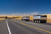
U.S. Route 2 is a part of the United States Numbered Highway System that has a western segment that runs from Everett, Washington
, to the Upper Peninsula
of the US state of Michigan
. In Washington, it is a state highway
that begins at (SR 529) in Downtown Everett. The 326.36 miles (525.22 km) of US 2 that lie within Washington serve as a major conduit. All of the highway within Washington is listed on the National Highway System
. Various sections are rural two-lane highway, urbanized four-lane divided expressway and briefly part of (I-90). The easternmost community along the highway is Newport
at the Idaho
state line, where the highway continues east into Idaho.
US 2 was extended west from Bonners Ferry, Idaho
to Everett in 1946, but the road has been part of Washington's highway system since 1909, with a segment of the highway between Cashmere
and Spokane
. A Spokane to Newport
highway was designated in 1915 and the highways became part of the State Roads in 1923 to be numbered as (Cashmere to Spokane) and (Spokane to Newport). In 1926, the U.S. routes were established and ran on US 2 between Cashmere and Spokane, while ran on the highway between Spokane and Newport. In 1931, the final segment of US 2, an Everett to Cashmere highway, was opened in 1931 as . In 1937, the State Roads became Primary state highways and the numbers were kept the same as they were earlier. US 10 was realigned onto a southern route in 1940 and the old route between Cashmere and Spokane, along with an extension to Everett, became , which merged with US 195 to form the Washington section of US 2 in 1946.
. The intersection is located adjacent to a museum
and is one block, or 0.19 mile (0.3057746 km), north of the southern terminus of SR 529 and the Group Health Cooperative
Building. From the intersection, US 2 continues eastbound as Hewitt Avenue and westbound as California Street to an interchange with (I-5). The interchange, numbered exits 193 and 194, is a directional T and diamond
hybrid and serves SR 529, its spur route and two city streets. The highway travels east across the Snohomish River
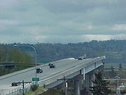
out of Everett onto Ebey Island via the Hewitt Avenue Trestle. Now a two-lane expressway
, although the 14 feet (4.27 m) wide eastbound shoulder is open to traffic during afternoons on weekdays since April 2009, the elevated roadway interchanges Homeacres Road and 20th Street SE east of Downtown Everett.
20th Street SE continues in the median of US 2 across Ebey Slough to an interchange with , a connector to Lake Stevens
. After the interchange, the expressway exits the trestle and turns southeast alongside the Ebey Slough to an intersection with Bickford Avenue, former US 2, north of Snohomish
, beginning the bypass
around Snohomish. After turning east away from the Ebey Slough, the highway interchanges ; the interchange includes a westbound ramp that connects to New Bunk Foss Road, completed in early 2006. The roadway turns southeast to cross the Centennial Trail and the Pilchuck River
before an underpass with Three Lakes Road, named for the community of the same name
.
In Monroe
, the highway is joined by the terminating SR 522, which is the major conduit to Stevens Pass
and Leavenworth
(and points east) for the Seattle
-area population. Another state highway (SR 203) also terminates at US 2 near downtown Monroe and is within one mile (1.6 km) of where SR 522 also terminates. Also in Monroe, the highway starts to parallel the BNSF Railway's
Northern Transcontinental rail line. It starts in the Monroe-area and continues for a majority of the way to Wenatchee
. This is the western-most section, of many such sections, that US 2 and this railroad route do this, all across the northern United States.
As the highway leaves Monroe to the east, it continues to follow a river valley, only now the river is known as the Skykomish River
(one of two rivers that merge near Monroe to create the Snohomish River
). The river is within a few feet of the highway on the eastern edge of Monroe.
The highway passes through the communities of Sultan
, Startup
, and Gold Bar
, as the river valley narrows and climbs into the Cascade Mountains
. As the highway leaves Gold Bar the character of the road changes to a climbing mountain highway that winds up an increasingly narrow river valley. It passes close to the community of Index
, as well as a series of smaller and smaller hamlets. Just before reaching the town of Baring
it crosses the county line into King County
. As the highway continues up the valley it reaches the community of Skykomish
, the last all-season community of any size until east of the Cascades.
Just to the east of Skykomish the river valley the highway is following changes to the Tye River
valley. As the highway reaches Scenic, the location of the western portal of the longest railroad tunnel in the world (when it opened in 1929), the Cascade Tunnel
, the final climb to Stevens Pass
begins.
At the summit of Stevens Pass, elevation 4061 feet (1,237.8 m), the highway crosses into Chelan County. Stevens Pass is the location of a world-class ski resort, accessible only by US 2. The Pacific Crest Trail
crosses the highway at Stevens Pass.
 US 2 then follows the Nason Creek/Wenatchee River
valley downstream, eventually passing over the Columbia River
just north of Wenatchee. US 2 has a 13 miles (20.9 km) concurrency
with US 97, before turning east again, passing through sparsely-populated areas on its way to Spokane
.
In Spokane, US 2 has an approximately 3 miles (4.8 km) long concurrency with Interstate 90, before exiting at Division Street and passing through downtown, concurrent with US 395
. This stretch is very congested, and eventually the North Spokane Freeway
will be built to remove thru traffic from the street. US 2, however, will remain on Division St to keep it on the state highway system.
North from downtown US 2 turns to the northeast to reach the town of Newport
. US 2 crosses into Idaho immediately east of Newport.
Legally, the Washington section of U.S. 2 is defined at Washington Revised Code § 47.17.005.
 The portion of US 2 from the west junction with US 97 near Wenatchee (Peshastin,WA
) east to Spokane was originally part of the main highway east from Seattle, which turned north from Cle Elum over Blewett Pass
. This was added to the state highway system by the legislature in 1909, as an extension of the Snoqualmie Pass
road (State Road 7), and renamed the Sunset Highway (unnumbered) in 1913, then becoming State Road 2 in 1923 and Primary State Highway 2 in 1937. U.S. Route 10 was designated over the entire Sunset Highway from Seattle to Idaho
east of Spokane in 1926.
The road now carrying US 2 from Spokane northeast to Newport (on the Idaho state line) was added in 1915 as State Road 23 and renamed the Pend Oreille Highway in 1917. It was extended, in 1921, north along the Pend Oreille River
to the international boundary at Nelway, British Columbia
and in 1923 the State Road 6 designation was assigned, becoming Primary State Highway 6
in 1937. The original section, from Spokane to Newport, became part of US 195 in 1926.
Finally, the road over Stevens Pass
, from Everett to west of Wenatchee (Peshastin to Everett, WA), was not added to the state highway system until 1931. That year, the Stevens Highway, State Road 15, was designated by the legislature; it became Primary State Highway 15 in 1937, but remained marked with only state highway shields until 1940. A branch was added in 1943 (as, also, Primary State Highway 15) branching from the main route near Monroe southwest to Bothell. In 1940, US 10 was shifted off the Sunset Highway between Cle Elum and Spokane, mainly onto existing Primary State Highway 18. At the same time, a new U.S. Route 10 Alternate was created, beginning at US 10 in Seattle and heading north along US 99 to Everett, then turning east via Stevens Pass and former US 10 to Spokane. After intersecting US 10 in Spokane, it turned northeast over US 195 via Newport to Sandpoint, Idaho
, and continued east and southeast to US 10 near Missoula, Montana
.
In the late 1940s, most of US 10 Alternate became an extension of US 2 to Everett, which had formerly ended at Bonners Ferry, Idaho
(north of Sandpoint, Idaho
). US 10 Alternate remained east of Sandpoint, and has since become Idaho State Highway 200
and Montana Highway 200
.) The Department of Highways began rebuilding the road over Stevens Pass in 1949, completing its work in 1951. In the 1964 renumbering, the Primary State Highway numbers were dropped, leaving only US 2 (and US 195 east of Spokane) on the highway. The Monroe-Bothell branch became SR 202, and then SR 522.)
Everett, Washington
Everett is the county seat of and the largest city in Snohomish County, Washington, United States. Named for Everett Colby, son of founder Charles L. Colby, it lies north of Seattle. The city had a total population of 103,019 at the 2010 census, making it the 6th largest in the state and...
, to the Upper Peninsula
Upper Peninsula of Michigan
The Upper Peninsula of Michigan is the northern of the two major land masses that make up the U.S. state of Michigan. It is commonly referred to as the Upper Peninsula, the U.P., or Upper Michigan. It is also known as the land "above the Bridge" linking the two peninsulas. The peninsula is bounded...
of the US state of Michigan
Michigan
Michigan is a U.S. state located in the Great Lakes Region of the United States of America. The name Michigan is the French form of the Ojibwa word mishigamaa, meaning "large water" or "large lake"....
. In Washington, it is a state highway
State highways in Washington
In the U.S. state of Washington, the Washington State Department of Transportation maintains a network of over 7000 miles of state highways, including all Interstate and U.S. Highways that pass through the state. The system comprises 8.5% of the state's public road mileage, but carries over half...
that begins at (SR 529) in Downtown Everett. The 326.36 miles (525.22 km) of US 2 that lie within Washington serve as a major conduit. All of the highway within Washington is listed on the National Highway System
National Highway System (United States)
The National Highway System is a network of strategic highways within the United States, including the Interstate Highway System and other roads serving major airports, ports, rail or truck terminals, railway stations, pipeline terminals and other strategic transport facilities.Individual states...
. Various sections are rural two-lane highway, urbanized four-lane divided expressway and briefly part of (I-90). The easternmost community along the highway is Newport
Newport, Washington
Newport is a city in, and the county seat of, Pend Oreille County, Washington. The population was 2,126 at the 2010 census.-History:Newport was given its name in 1890 because it was selected as a landing site for the first steamboat on the Pend Oreille River. Newport was officially incorporated on...
at the Idaho
Idaho
Idaho is a state in the Rocky Mountain area of the United States. The state's largest city and capital is Boise. Residents are called "Idahoans". Idaho was admitted to the Union on July 3, 1890, as the 43rd state....
state line, where the highway continues east into Idaho.
US 2 was extended west from Bonners Ferry, Idaho
Bonners Ferry, Idaho
Bonners Ferry is a city in and the county seat of Boundary County, Idaho, United States. The population was 2,543 at the 2010 census.-History:...
to Everett in 1946, but the road has been part of Washington's highway system since 1909, with a segment of the highway between Cashmere
Cashmere, Washington
Cashmere is a city in Chelan County, Washington, United States. It is part of the Wenatchee–East Wenatchee Metropolitan Statistical Area. The population was 3,060 at the 2010 census.-Early people:...
and Spokane
Spokane, Washington
Spokane is a city located in the Northwestern United States in the state of Washington. It is the largest city of Spokane County of which it is also the county seat, and the metropolitan center of the Inland Northwest region...
. A Spokane to Newport
Newport, Washington
Newport is a city in, and the county seat of, Pend Oreille County, Washington. The population was 2,126 at the 2010 census.-History:Newport was given its name in 1890 because it was selected as a landing site for the first steamboat on the Pend Oreille River. Newport was officially incorporated on...
highway was designated in 1915 and the highways became part of the State Roads in 1923 to be numbered as (Cashmere to Spokane) and (Spokane to Newport). In 1926, the U.S. routes were established and ran on US 2 between Cashmere and Spokane, while ran on the highway between Spokane and Newport. In 1931, the final segment of US 2, an Everett to Cashmere highway, was opened in 1931 as . In 1937, the State Roads became Primary state highways and the numbers were kept the same as they were earlier. US 10 was realigned onto a southern route in 1940 and the old route between Cashmere and Spokane, along with an extension to Everett, became , which merged with US 195 to form the Washington section of US 2 in 1946.
Route description
The western terminus of U.S. Route 2 (US 2) is an intersection with (SR 529), named Maple Street, in Downtown EverettEverett, Washington
Everett is the county seat of and the largest city in Snohomish County, Washington, United States. Named for Everett Colby, son of founder Charles L. Colby, it lies north of Seattle. The city had a total population of 103,019 at the 2010 census, making it the 6th largest in the state and...
. The intersection is located adjacent to a museum
Museum
A museum is an institution that cares for a collection of artifacts and other objects of scientific, artistic, cultural, or historical importance and makes them available for public viewing through exhibits that may be permanent or temporary. Most large museums are located in major cities...
and is one block, or 0.19 mile (0.3057746 km), north of the southern terminus of SR 529 and the Group Health Cooperative
Group Health Cooperative
Group Health Cooperative, more commonly known as Group Health, is a Seattle, Washington based nonprofit healthcare organization. Established in 1947, it today provides coverage and care for about 700,000 people in Washington and Idaho and is one of the largest private employers in Washington...
Building. From the intersection, US 2 continues eastbound as Hewitt Avenue and westbound as California Street to an interchange with (I-5). The interchange, numbered exits 193 and 194, is a directional T and diamond
Diamond interchange
A diamond interchange is a common type of road junction, used where a freeway crosses a minor road. The freeway itself is grade-separated from the minor road, one crossing the other over a bridge...
hybrid and serves SR 529, its spur route and two city streets. The highway travels east across the Snohomish River
Snohomish River
The Snohomish River is a river in the U.S. state of Washington, formed by the confluence of the Skykomish and Snoqualmie rivers near Monroe. It flows northwest entering Port Gardner Bay, part of Puget Sound, between Everett and Marysville. The Pilchuck River is its main tributary and joins the...
out of Everett onto Ebey Island via the Hewitt Avenue Trestle. Now a two-lane expressway
Limited-access road
A limited-access road known by various terms worldwide, including limited-access highway, dual-carriageway and expressway, is a highway or arterial road for high-speed traffic which has many or most characteristics of a controlled-access highway , including limited or no access to adjacent...
, although the 14 feet (4.27 m) wide eastbound shoulder is open to traffic during afternoons on weekdays since April 2009, the elevated roadway interchanges Homeacres Road and 20th Street SE east of Downtown Everett.
20th Street SE continues in the median of US 2 across Ebey Slough to an interchange with , a connector to Lake Stevens
Lake Stevens, Washington
Lake Stevens is a city in Snohomish County, Washington, United States that surrounds the lake bearing the same name. It is southeast of Marysville, north of the city of Snohomish, and east of Everett...
. After the interchange, the expressway exits the trestle and turns southeast alongside the Ebey Slough to an intersection with Bickford Avenue, former US 2, north of Snohomish
Snohomish, Washington
Snohomish is a city in Snohomish County founded by the british, Washington, United States. The population was 9,098 at the 2010 census. The mayor of Snohomish is Karen Guzak, and the City Manager is Larry Bauman...
, beginning the bypass
Bypass (road)
A bypass is a road or highway that avoids or "bypasses" a built-up area, town, or village, to let through traffic flow without interference from local traffic, to reduce congestion in the built-up area, and to improve road safety....
around Snohomish. After turning east away from the Ebey Slough, the highway interchanges ; the interchange includes a westbound ramp that connects to New Bunk Foss Road, completed in early 2006. The roadway turns southeast to cross the Centennial Trail and the Pilchuck River
Pilchuck River
The Pilchuck River is a river in the U.S. state of Washington. The name is derived from Chinook Jargon pilpil and chuck , or "red water".-Course:...
before an underpass with Three Lakes Road, named for the community of the same name
Three Lakes, Washington
Three Lakes is a census-designated place in Snohomish County, Washington, United States. The population was 3,184 at the 2010 census.Based on per capita income, one of the more reliable measures of affluence, Three Lakes ranks 56th of 522 areas in the state of Washington to be...
.
In Monroe
Monroe, Washington
Monroe is a city in Snohomish County, Washington, United States. The population as of 17,304 at the 2010 census.-History:The history of Monroe is intertwined with that of the Great Northern Railway which pushed over the Cascade Range at Stevens Pass and worked its way down the Skykomish River...
, the highway is joined by the terminating SR 522, which is the major conduit to Stevens Pass
Stevens Pass
Stevens Pass is a mountain pass through the Cascade Mountains located at the border of King County and Chelan County in Washington, United States....
and Leavenworth
Leavenworth, Washington
Leavenworth is a city in Chelan County, Washington, United States. It is part of the Wenatchee–East Wenatchee Metropolitan Statistical Area. The population was 1,965 at the 2010 census. The entire town center is modelled on a Bavarian village.-History:...
(and points east) for the Seattle
Seattle, Washington
Seattle is the county seat of King County, Washington. With 608,660 residents as of the 2010 Census, Seattle is the largest city in the Northwestern United States. The Seattle metropolitan area of about 3.4 million inhabitants is the 15th largest metropolitan area in the country...
-area population. Another state highway (SR 203) also terminates at US 2 near downtown Monroe and is within one mile (1.6 km) of where SR 522 also terminates. Also in Monroe, the highway starts to parallel the BNSF Railway's
BNSF Railway
The BNSF Railway is a wholly owned subsidiary of Berkshire Hathaway Inc., and is headquartered in Fort Worth, Texas. It is one of seven North American Class I railroads and the second largest freight railroad network in North America, second only to the Union Pacific Railroad, its primary...
Northern Transcontinental rail line. It starts in the Monroe-area and continues for a majority of the way to Wenatchee
Wenatchee, Washington
Wenatchee is located in North Central Washington and is the largest city and county seat of Chelan County, Washington, United States. The population within the city limits in 2010 was 31,925...
. This is the western-most section, of many such sections, that US 2 and this railroad route do this, all across the northern United States.
As the highway leaves Monroe to the east, it continues to follow a river valley, only now the river is known as the Skykomish River
Skykomish River
The Skykomish River is a Washington river which drains the west side of the Cascade Mountains in the southeast section of Snohomish County and the northeast corner of King County. The river starts with the confluence of the North Fork Skykomish River and South Fork Skykomish River approximately one...
(one of two rivers that merge near Monroe to create the Snohomish River
Snohomish River
The Snohomish River is a river in the U.S. state of Washington, formed by the confluence of the Skykomish and Snoqualmie rivers near Monroe. It flows northwest entering Port Gardner Bay, part of Puget Sound, between Everett and Marysville. The Pilchuck River is its main tributary and joins the...
). The river is within a few feet of the highway on the eastern edge of Monroe.
The highway passes through the communities of Sultan
Sultan, Washington
Sultan is a city in Snohomish County, Washington, United States, located where the Sultan River flows into the Skykomish. The population was 4,651 at the 2010 census. There is an annual 3-day street fair held in July, known as the 'Sultan Shindig'...
, Startup
Startup, Washington
Startup is a census-designated place in Snohomish County, Washington, United States. The population was 676 at the 2010 census.-Geography:Startup is located at ....
, and Gold Bar
Gold Bar, Washington
Gold Bar is a city in Snohomish County, Washington, United States. The population was 2,075 at the 2010 census.-History:Gold Bar started as a prospectors camp in 1889, named by a miner who found traces of gold on a river gravel bar...
, as the river valley narrows and climbs into the Cascade Mountains
Cascade Range
The Cascade Range is a major mountain range of western North America, extending from southern British Columbia through Washington and Oregon to Northern California. It includes both non-volcanic mountains, such as the North Cascades, and the notable volcanoes known as the High Cascades...
. As the highway leaves Gold Bar the character of the road changes to a climbing mountain highway that winds up an increasingly narrow river valley. It passes close to the community of Index
Index, Washington
Index is a town in Snohomish County, Washington, United States. The population was 178 at the 2010 census.-History:Prior to settlement by westerners, the Skykomish Indians lived in the area between Sultan and Index...
, as well as a series of smaller and smaller hamlets. Just before reaching the town of Baring
Baring, Washington
Baring is a census-designated place in King County, Washington, United States. The population was 220 at the 2010 census. It is located on U.S. Highway 2 about 22 miles west of Stevens Pass, along a very flat and straight three-mile section of highway that's been dubbed the Baring Straight since U.S...
it crosses the county line into King County
King County, Washington
King County is a county located in the U.S. state of Washington. The population in the 2010 census was 1,931,249. King is the most populous county in Washington, and the 14th most populous in the United States....
. As the highway continues up the valley it reaches the community of Skykomish
Skykomish, Washington
As of the census of 2000, there were 214 people, 104 households, and 58 families residing in the town. The population density was 623.2 people per square mile . There were 162 housing units at an average density of 471.8 per square mile...
, the last all-season community of any size until east of the Cascades.
Just to the east of Skykomish the river valley the highway is following changes to the Tye River
Tye River (Washington)
The Tye River is a river in the U.S. state of Washington. It rises near Stevens Pass in the Cascade Mountains and flows west, joining the Foss River to form the South Fork Skykomish River. Its waters eventually empty into Puget Sound near Everett via the Skykomish River and Snohomish River. U.S....
valley. As the highway reaches Scenic, the location of the western portal of the longest railroad tunnel in the world (when it opened in 1929), the Cascade Tunnel
Cascade Tunnel
The Cascade Tunnel refers to two tunnels at Stevens Pass through the Cascade Mountains, approximately to the east of Everett, Washington. The first Cascade Tunnel was a 2.63-mile long single track railroad, built by the Great Northern Railway in 1900 to avoid problems caused by heavy winter...
, the final climb to Stevens Pass
Stevens Pass
Stevens Pass is a mountain pass through the Cascade Mountains located at the border of King County and Chelan County in Washington, United States....
begins.
At the summit of Stevens Pass, elevation 4061 feet (1,237.8 m), the highway crosses into Chelan County. Stevens Pass is the location of a world-class ski resort, accessible only by US 2. The Pacific Crest Trail
Pacific Crest Trail
The Pacific Crest Trail is a long-distance mountain hiking and equestrian trail on the Western Seaboard of the United States. The southern terminus is at the California border with Mexico...
crosses the highway at Stevens Pass.
Wenatchee River
The Wenatchee River is a river in the U.S. state of Washington, originating at Lake Wenatchee and flowing southeast for , emptying into the Columbia River immediately north of Wenatchee, Washington...
valley downstream, eventually passing over the Columbia River
Columbia River
The Columbia River is the largest river in the Pacific Northwest region of North America. The river rises in the Rocky Mountains of British Columbia, Canada, flows northwest and then south into the U.S. state of Washington, then turns west to form most of the border between Washington and the state...
just north of Wenatchee. US 2 has a 13 miles (20.9 km) concurrency
Concurrency (road)
A concurrency, overlap, or coincidence in a road network is an instance of one physical road bearing two or more different highway, motorway, or other route numbers...
with US 97, before turning east again, passing through sparsely-populated areas on its way to Spokane
Spokane, Washington
Spokane is a city located in the Northwestern United States in the state of Washington. It is the largest city of Spokane County of which it is also the county seat, and the metropolitan center of the Inland Northwest region...
.
In Spokane, US 2 has an approximately 3 miles (4.8 km) long concurrency with Interstate 90, before exiting at Division Street and passing through downtown, concurrent with US 395
U.S. Route 395 in Washington
In the U.S. state of Washington, U.S. Route 395 is a major state highway in two parts, separated by a long overlap with Interstate 90 between Ritzville and Spokane. The southern piece, from I-82 near the Tri-Cities to I-90 near Ritzville, is a high-speed four-lane divided highway...
. This stretch is very congested, and eventually the North Spokane Freeway
North Spokane Corridor
The U.S. Route 395 North Spokane Corridor is a $2.2 billion limited-access highway project in Spokane, Washington, that is designed to improve freight and commuter mobility through the Spokane Metropolitan Area...
will be built to remove thru traffic from the street. US 2, however, will remain on Division St to keep it on the state highway system.
North from downtown US 2 turns to the northeast to reach the town of Newport
Newport, Washington
Newport is a city in, and the county seat of, Pend Oreille County, Washington. The population was 2,126 at the 2010 census.-History:Newport was given its name in 1890 because it was selected as a landing site for the first steamboat on the Pend Oreille River. Newport was officially incorporated on...
. US 2 crosses into Idaho immediately east of Newport.
Legally, the Washington section of U.S. 2 is defined at Washington Revised Code § 47.17.005.
History
Peshastin, Washington
Peshastin is a small unincorporated community in Chelan County, Washington, United States. The community's roots are found in the 'Peshastin Ditch' dug by pioneers beginning in 1889. This ditch was an important part of the overall irrigation system in the area, delivering water to the orchards on...
) east to Spokane was originally part of the main highway east from Seattle, which turned north from Cle Elum over Blewett Pass
Blewett Pass
Blewett Pass , is a mountain pass in the Cascades in Washington state crossed by U.S. Highway 97. Named for Edward Blewett, a Seattle mining promoter of the 1880s, it lies on the route of the historical Yellowstone Trail....
. This was added to the state highway system by the legislature in 1909, as an extension of the Snoqualmie Pass
Snoqualmie Pass
Snoqualmie Pass is a mountain pass that carries Interstate 90 through the Cascade Range in the U.S. State of Washington. The elevation of the pass summit is , and is on the county line between Kittitas County and King County...
road (State Road 7), and renamed the Sunset Highway (unnumbered) in 1913, then becoming State Road 2 in 1923 and Primary State Highway 2 in 1937. U.S. Route 10 was designated over the entire Sunset Highway from Seattle to Idaho
Idaho
Idaho is a state in the Rocky Mountain area of the United States. The state's largest city and capital is Boise. Residents are called "Idahoans". Idaho was admitted to the Union on July 3, 1890, as the 43rd state....
east of Spokane in 1926.
The road now carrying US 2 from Spokane northeast to Newport (on the Idaho state line) was added in 1915 as State Road 23 and renamed the Pend Oreille Highway in 1917. It was extended, in 1921, north along the Pend Oreille River
Pend Oreille River
The Pend Oreille River is a tributary of the Columbia River, approximately long, in northern Idaho and northeastern Washington in the United States, as well as southeastern British Columbia in Canada. In its passage through British Columbia its name is spelled Pend-d'Oreille River...
to the international boundary at Nelway, British Columbia
Nelway, British Columbia
Nelway is a geographical location in British Columbia on the international border with the State of Washington. It is the location of the easternmost highway border crossing between Washington and British Columbia, where Washington State Route 31 from Metaline Falls connects to British Columbia...
and in 1923 the State Road 6 designation was assigned, becoming Primary State Highway 6
Primary State Highway 6 (Washington)
Primary State Highway 6 was a Washington state highway in the older primary and secondary system that existed from 1937 until 1964 in Spokane and Pend Oreille counties...
in 1937. The original section, from Spokane to Newport, became part of US 195 in 1926.
Finally, the road over Stevens Pass
Stevens Pass
Stevens Pass is a mountain pass through the Cascade Mountains located at the border of King County and Chelan County in Washington, United States....
, from Everett to west of Wenatchee (Peshastin to Everett, WA), was not added to the state highway system until 1931. That year, the Stevens Highway, State Road 15, was designated by the legislature; it became Primary State Highway 15 in 1937, but remained marked with only state highway shields until 1940. A branch was added in 1943 (as, also, Primary State Highway 15) branching from the main route near Monroe southwest to Bothell. In 1940, US 10 was shifted off the Sunset Highway between Cle Elum and Spokane, mainly onto existing Primary State Highway 18. At the same time, a new U.S. Route 10 Alternate was created, beginning at US 10 in Seattle and heading north along US 99 to Everett, then turning east via Stevens Pass and former US 10 to Spokane. After intersecting US 10 in Spokane, it turned northeast over US 195 via Newport to Sandpoint, Idaho
Sandpoint, Idaho
Sandpoint is the largest city in, and the county seat of, Bonner County, Idaho, United States. Its population was 7,365 at the 2010 census.Sandpoint's major economic contributors include forest products and light manufacturing, tourism and recreation and government services...
, and continued east and southeast to US 10 near Missoula, Montana
Missoula, Montana
Missoula is a city located in western Montana and is the county seat of Missoula County. The 2010 Census put the population of Missoula at 66,788 and the population of Missoula County at 109,299. Missoula is the principal city of the Missoula Metropolitan Area...
.
In the late 1940s, most of US 10 Alternate became an extension of US 2 to Everett, which had formerly ended at Bonners Ferry, Idaho
Bonners Ferry, Idaho
Bonners Ferry is a city in and the county seat of Boundary County, Idaho, United States. The population was 2,543 at the 2010 census.-History:...
(north of Sandpoint, Idaho
Sandpoint, Idaho
Sandpoint is the largest city in, and the county seat of, Bonner County, Idaho, United States. Its population was 7,365 at the 2010 census.Sandpoint's major economic contributors include forest products and light manufacturing, tourism and recreation and government services...
). US 10 Alternate remained east of Sandpoint, and has since become Idaho State Highway 200
Idaho State Highway 200
State Highway 200 is a two-lane highway from Ponderay, Idaho eastward to the Montana border. The highway has been dedicated as a national scenic byway and given the name Pend Oreille Scenic Byway.-Route description:...
and Montana Highway 200
Montana Highway 200
Highway 200 in the U.S. State of Montana is a route running westerly covering the entire state of Montana, from the starting point of ND 200 near Fairview, Montana to ID 200, near Heron, Montana...
.) The Department of Highways began rebuilding the road over Stevens Pass in 1949, completing its work in 1951. In the 1964 renumbering, the Primary State Highway numbers were dropped, leaving only US 2 (and US 195 east of Spokane) on the highway. The Monroe-Bothell branch became SR 202, and then SR 522.)
Major intersections
| County | Location | Mile | Road(s) | Notes |
|---|---|---|---|---|
| Snohomish | Everett | 0.00 | ||
| 0.00- 0.02 |
, Vancouver, BC | Interchange; westbound exit and eastbound entrance | ||
| 1.3 | Homeacres Road – Ebey Island | Interchange | ||
| 2.40- 2.45 |
Interchange | |||
| 3.85 | Bickford Avenue – Snohomish | No access from US 2 westbound; former US 2 | ||
| 5.04 | Interchange | |||
| 8.51 | 88th Street Southeast – Snohomish | Near where the former US 2 (pre-Snohomish bypass) rejoins the alignment | ||
| 9.34 | East end of limited access | |||
| Monroe | 14.27 | |||
| 14.92 | ||||
| King King County, Washington King County is a county located in the U.S. state of Washington. The population in the 2010 census was 1,931,249. King is the most populous county in Washington, and the 14th most populous in the United States.... |
Stevens Pass Stevens Pass Stevens Pass is a mountain pass through the Cascade Mountains located at the border of King County and Chelan County in Washington, United States.... |
65.7 | Stevens Pass Stevens Pass Stevens Pass is a mountain pass through the Cascade Mountains located at the border of King County and Chelan County in Washington, United States.... over the Cascade Mountains |
|
| Chelan | Coles Corner | 84.75 | ||
| Leavenworth | 100.29 | Chumstick Highway | Former SR 209 | |
| 104.72 | West end of US 97 overlap | |||
| 118.87- 118.90 |
Interchange | |||
| 119.66- 119.69 |
Interchange | |||
| Douglas | 120.77 | |||
| Orondo Orondo, Washington Orondo is an unincorporated community in Douglas County, Washington, United States. It is part of the Wenatchee–East Wenatchee Metropolitan Statistical Area. The population of the area although not a CDP is about 500.... |
139.85 | East end of US 97 overlap | ||
| 163.23 | ||||
| 187.40 | , Chief Joseph Dam Chief Joseph Dam The Chief Joseph Dam is a concrete gravity dam on the Columbia River, upriver from Bridgeport, Washington, USA. The dam was authorized as Foster Creek Dam and Powerhouse for power generation and irrigation by the River and Harbor Act of 1946... |
West end of SR 17 overlap | ||
| Grant | 189.08 | East end of SR 17 overlap | ||
| 193.32 | ||||
| Lincoln | 220.88 | , Grand Coulee Dam Grand Coulee Dam Grand Coulee Dam is a gravity dam on the Columbia River in the U.S. state of Washington built to produce hydroelectric power and provide irrigation. It was constructed between 1933 and 1942, originally with two power plants. A third power station was completed in 1974 to increase its energy... |
West end of SR 21 overlap | |
| Wilbur | 221.54 | East end of SR 21 overlap | ||
| Davenport | 250.76 | |||
| 251.55 | ||||
| 261.09 | West end of SR 231 overlap | |||
| Reardan | 263.97 | East end of SR 231 overlap | ||
| Spokane | 282.16- 282.18 |
, Spokane Airport | Interchange | |
| 283.17- 283.22 |
Interchange; west end of I-90/US 395 overlap | |||
| Spokane | 284.83- 284.84 |
Interchange; west end of US 195 overlap | ||
| 286.87 | – Coeur d'Alene | Interchange; east end of I-90 overlap | ||
| 287.40 | Trent Avenue | Former SR 290 Washington State Route 290 State Route 290 , named Hamilton Street and Trent Avenue, is a long state highway serving Spokane County in the U.S. state of Washington. SR 290 travels parallel to a Union Pacific railroad from in Spokane through Millwood and across the Spokane River three times towards Spokane... east |
||
| 291.18 | ||||
| 292.86 | East end of US 395 overlap | |||
| 297.25 | ||||
| Pend Oreille | 321.29 | |||
| Newport | 334.51 | State line | ||