

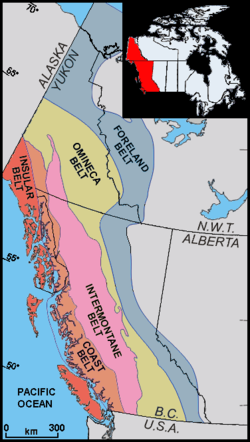
Intermontane Belt
Encyclopedia
Pacific Northwest
The Pacific Northwest is a region in northwestern North America, bounded by the Pacific Ocean to the west and, loosely, by the Rocky Mountains on the east. Definitions of the region vary and there is no commonly agreed upon boundary, even among Pacific Northwesterners. A common concept of the...
of North America
North America
North America is a continent wholly within the Northern Hemisphere and almost wholly within the Western Hemisphere. It is also considered a northern subcontinent of the Americas...
, stretching from northern Washington into British Columbia
British Columbia
British Columbia is the westernmost of Canada's provinces and is known for its natural beauty, as reflected in its Latin motto, Splendor sine occasu . Its name was chosen by Queen Victoria in 1858...
, Yukon
Yukon
Yukon is the westernmost and smallest of Canada's three federal territories. It was named after the Yukon River. The word Yukon means "Great River" in Gwich’in....
, and Alaska
Alaska
Alaska is the largest state in the United States by area. It is situated in the northwest extremity of the North American continent, with Canada to the east, the Arctic Ocean to the north, and the Pacific Ocean to the west and south, with Russia further west across the Bering Strait...
. It comprises rolling hill
Hill
A hill is a landform that extends above the surrounding terrain. Hills often have a distinct summit, although in areas with scarp/dip topography a hill may refer to a particular section of flat terrain without a massive summit A hill is a landform that extends above the surrounding terrain. Hills...
s, high plateau
Plateau
In geology and earth science, a plateau , also called a high plain or tableland, is an area of highland, usually consisting of relatively flat terrain. A highly eroded plateau is called a dissected plateau...
s and deeply cut valley
Valley
In geology, a valley or dale is a depression with predominant extent in one direction. A very deep river valley may be called a canyon or gorge.The terms U-shaped and V-shaped are descriptive terms of geography to characterize the form of valleys...
s. The rocks in the belt have very little similarities with the North American continent.
Geology
The formation of the Intermontane Belt is complex. It began forming during the early JurassicJurassic
The Jurassic is a geologic period and system that extends from about Mya to Mya, that is, from the end of the Triassic to the beginning of the Cretaceous. The Jurassic constitutes the middle period of the Mesozoic era, also known as the age of reptiles. The start of the period is marked by...
period when an island arc
Volcanic arc
A volcanic arc is a chain of volcanoes positioned in an arc shape as seen from above. Offshore volcanoes form islands, resulting in a volcanic island arc. Generally they result from the subduction of an oceanic tectonic plate under another tectonic plate, and often parallel an oceanic trench...
collided against a pre-existing continental margin
Continental margin
The continental margin is the zone of the ocean floor that separates the thin oceanic crust from thick continental crust. Continental margins constitute about 28% of the oceanic area....
called the Intermontane Islands
Intermontane Islands
The Intermontane Islands were a giant chain of active volcanic islands somewhere in the Pacific Ocean during the Triassic time beginning around 245 million years ago. They were 600 to long and rode atop a microplate known as the Intermontane Plate...
. This island arc is believed to have formed on a pre-existing tectonic plate
Plate tectonics
Plate tectonics is a scientific theory that describes the large scale motions of Earth's lithosphere...
called the Intermontane Plate
Intermontane Plate
The Intermontane Plate was an ancient oceanic tectonic plate that lay on the west coast of North America about 195 million years ago. The Intermontane Plate had a chain of volcanic islands called the Intermontane Islands. The Intermontane Islands had been accumulating as a volcanic chain in the...
about 245 million years ago by subduction
Subduction
In geology, subduction is the process that takes place at convergent boundaries by which one tectonic plate moves under another tectonic plate, sinking into the Earth's mantle, as the plates converge. These 3D regions of mantle downwellings are known as "Subduction Zones"...
of the former Insular Plate
Insular Plate
The Insular Plate was an ancient oceanic plate that began subducting under the west-coast of North America around the early Cretaceous time. The Insular Plate had a chain of active volcanic islands that were called the Insular Islands...
during the Triassic
Triassic
The Triassic is a geologic period and system that extends from about 250 to 200 Mya . As the first period of the Mesozoic Era, the Triassic follows the Permian and is followed by the Jurassic. Both the start and end of the Triassic are marked by major extinction events...
period. This subduction zone records another subduction zone called the Intermontane Trench
Intermontane Trench
The Intermontane Trench was an ancient oceanic trench during the Triassic time. The trench was probably 600 to 800 miles long, parallel to the west coast of North America. The ocean that the trench was located in was called the Slide Mountain Ocean....
under an ancient ocean between the Intermontane Islands and the former continental margin of North America called the Slide Mountain Ocean
Slide Mountain Ocean
The Slide Mountain Ocean was an ancient ocean that existed between the Intermontane Islands and North America in the Triassic time beginning around 245 million years ago. Its name origin comes from the Slide Mountain Terrane, a region made of rocks from the floor of the ancient ocean...
. This arrangement of two parallel subduction zones is unusual because very few twin subduction zones exist on Earth; the Philippine Mobile Belt
Philippine Mobile Belt
The Philippine Mobile Belt is a complex portion of the tectonic boundary between the Eurasian Plate and the Philippine Sea Plate, comprising most of the country of the Philippines. It includes two subduction zones, the Manila Trench to the west and the Philippine Trench to the east, as well as the...
off the eastern coast of Asia
Asia
Asia is the world's largest and most populous continent, located primarily in the eastern and northern hemispheres. It covers 8.7% of the Earth's total surface area and with approximately 3.879 billion people, it hosts 60% of the world's current human population...
is an example of a modern twin subduction zone. As the Intermontane Plate drew closer to the pre-existing continental margin by ongoing subduction
Subduction
In geology, subduction is the process that takes place at convergent boundaries by which one tectonic plate moves under another tectonic plate, sinking into the Earth's mantle, as the plates converge. These 3D regions of mantle downwellings are known as "Subduction Zones"...
under the Slide Mountain Ocean, the Intermontane Islands drew closer to the former continental margin and coastline of western North America, supporting a pre-existing volcanic arc on the former continental margin of North America. As the North American Plate
North American Plate
The North American Plate is a tectonic plate covering most of North America, Greenland, Cuba, Bahamas, and parts of Siberia, Japan and Iceland. It extends eastward to the Mid-Atlantic Ridge and westward to the Chersky Range in eastern Siberia. The plate includes both continental and oceanic crust...
drifted west and the Intermontane Plate drifted east to the ancient continental margin of western North America, the Slide Mountain Ocean eventually closed by ongoing subduction under the Slide Mountain Ocean. The subduction zone eventually jammed and shut down completely about 180 million years ago, ending the volcanic arc on the ancient continental margin of western North America and the Intermontane Islands collided, forming the Intermontane Belt. This collision crushed and fold
Fold (geology)
The term fold is used in geology when one or a stack of originally flat and planar surfaces, such as sedimentary strata, are bent or curved as a result of permanent deformation. Synsedimentary folds are those due to slumping of sedimentary material before it is lithified. Folds in rocks vary in...
ed sedimentary
Sedimentary rock
Sedimentary rock are types of rock that are formed by the deposition of material at the Earth's surface and within bodies of water. Sedimentation is the collective name for processes that cause mineral and/or organic particles to settle and accumulate or minerals to precipitate from a solution....
and igneous rock
Igneous rock
Igneous rock is one of the three main rock types, the others being sedimentary and metamorphic rock. Igneous rock is formed through the cooling and solidification of magma or lava...
s, creating a mountain range
Mountain range
A mountain range is a single, large mass consisting of a succession of mountains or narrowly spaced mountain ridges, with or without peaks, closely related in position, direction, formation, and age; a component part of a mountain system or of a mountain chain...
called the Kootenay Fold Belt which existed in far eastern Washington State and British Columbia.
After the sedimentary and igneous rocks were folded and crushed, it resulted in the creation of a new continental shelf and coastline. This coastline and continental shelf was located adjacent to the eastern margin of Methow Valley. The Insular Plate continued to subduct under the new continental shelf and coastline about 130 million years ago during the mid Cretaceous
Cretaceous
The Cretaceous , derived from the Latin "creta" , usually abbreviated K for its German translation Kreide , is a geologic period and system from circa to million years ago. In the geologic timescale, the Cretaceous follows the Jurassic period and is followed by the Paleogene period of the...
period after the formation of the Intermontane Belt, supporting a new continental volcanic arc called the Omineca Arc
Omineca Arc
The Omineca Arc or Omineca Belt was a Jurassic through Cretaceous volcanic arc terrane in western North America, extending from Alaska through Yukon and British Columbia to Washington. The Omeneca is bounded by the Foreland Belt to the east and the Intermontane Belt to the west...
. Magma rising from the Omineca Arc successfully connected the Intermontane Belt to the mainland of North America, forming a chain of volcanoes from Washington to British Columbia that existed for about 60 million years. The ocean lying offshore during this period is called the Bridge River Ocean
Bridge River Ocean
The Bridge River Ocean was an ancient ocean that existed between North America and the Insular Islands during the Paleozoic time. Like the earlier Slide Mountain Ocean the Bridge River Ocean had a subduction zone on the ocean floor called the Insular Trench...
. About 115 million years ago, another island arc collided with the Pacific Northwest
Pacific Northwest
The Pacific Northwest is a region in northwestern North America, bounded by the Pacific Ocean to the west and, loosely, by the Rocky Mountains on the east. Definitions of the region vary and there is no commonly agreed upon boundary, even among Pacific Northwesterners. A common concept of the...
called the Insular Islands
Insular Islands
The Insular Islands were a giant chain of active volcanic islands somewhere in the Pacific Ocean during the Cretaceous time that rode on top a microplate called the Insular Plate, beginning around 130 million years ago. The Insular Islands were surrounded by two prehistoric oceans; the Panthalassa...
and caused the Bridge River Ocean to close. Like the earlier buildup of the Intermontane Islands, this island arc connected to the Intermontane Belt as magma solidified and rose beneath the arc. The compression of the collision created fractures and folds in the Intermontane Belt.
See also
- Geology of British ColumbiaGeology of British ColumbiaThe geology of British Columbia is a function of its location on the leading edge of the North American continent. The mountainous physiography and the diversity of rock types and ages hint at the complex geology, which is still undergoing revision despite a century of exploration and mapping.The...
- Insular BeltInsular BeltThe Insular Belt is a physiogeological region on the north western North American coast. It consist of three major island groups and many smaller islands and stretches from southern British Columbia into Alaska and the Yukon...
- Interior Platform
- Volcanism of Canada
- Volcanism of Western CanadaVolcanism of Western CanadaVolcanism of Western Canada produces lava flows, lava plateaus, lava domes, cinder cones, stratovolcanoes, shield volcanoes, submarine volcanoes, calderas, diatremes and maars, along with examples of more less common volcanic forms such as tuyas and subglacial mounds.-Volcanic belts:*Anahim...