

Noachian
Encyclopedia
The Noachian is a geologic system and early time period on the planet Mars
characterized by high rates of meteorite
and asteroid
impacts
and the presence of abundant surface water
. The absolute age of the Noachian period is uncertain but probably corresponds to the lunar Pre-Nectarian
to Early Imbrian periods of 4100 to 3700 million years ago, during the interval known as the Late Heavy Bombardment
. Many of the large impact basins on the Moon
and Mars formed at this time. The Noachian Period is roughly equivalent to the Earth’s Hadean
and early Archean
eons when the first life forms likely arose.
Noachian-aged terrains on Mars are prime spacecraft
landing sites to search for fossil
evidence of life
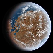
. During the Noachian, the atmosphere
of Mars was denser than it is today, and the climate possibly warm enough to allow rainfall. Large lakes and rivers were present in the southern hemisphere, and an ocean may have covered the low-lying northern plains. Extensive volcanism
occurred in the Tharsis
region, building up enormous masses of volcanic material (the Tharsis bulge) and releasing large quantities of gases into the atmosphere. Weathering
of surface rocks produced a diversity of clay minerals
(phyllosilicates) that formed under chemical conditions conducive to microbial life
.
Noachian chronology
Martian time periods are based on geologic mapping
of surface units from spacecraft images
. A surface unit is a terrain with a distinct texture, color, albedo
, spectral
property, or set of landforms that distinguish it from other surface units and is large enough to be shown on a map. Mappers use a stratigraphic
approach pioneered in the early 1960s for photogeologic studies of the Moon
. Although based on surface characteristics, a surface unit is not the surface itself or group of landform
s. It is an inferred geologic unit (e.g., formation) representing a sheetlike, wedgelike, or tabular body of rock that underlies the surface. A surface unit may be a crater ejecta deposit, lava flow, or any surface that can be represented in three dimensions as a discrete stratum
bound above or below by adjacent units (illustrated right). Using principles such as superpositioning
(illustrated left), cross-cutting relationships, and the relationship of impact crater density to age, geologists can place the units into an relative age
sequence from oldest to youngest. Units of similar age are grouped globally into larger, time-stratigraphic (chronostratigraphic
) units, called systems. For Mars, three systems are defined: the Noachian, Hesperian, and Amazonian. Geologic units lying below (older than) the Noachian are informally designated Pre-Noachian. The geologic time (geochronologic
) equivalent of the Noachian System is the Noachian Period. Rock or surface units of the Noachian System were formed or deposited during the Noachian Period.
Martian Time Periods (Millions of Years Ago)
, a heavily cratered highland region west of the Hellas
basin. The type area
of the Noachian System is in the Noachis quadrangle
(MC-27) around lat. 45°S, long. 20°E. At a large scale (>100 m), Noachian surfaces are very hilly and rugged, superficially resembling the lunar highlands. Noachian terrains consist of overlapping and interbedded ejecta blanket
s of many old craters. Mountainous rim materials and uplifted basement rock
from large impact basins are also common. (See Anseris Mons
, for example.) The number-density of large impact craters is very high, with about 400 craters greater than 8 km in diameter per million km2. Noachian-aged units cover roughly 40% of the Martian surface; they occur mainly in the southern highlands of the planet, but are also present over large areas in the north, such as in Tempe
and Xanthe
Terrae, Acheron Fossae
, and around the Isidis basin (Libya Montes
).
based on the physical rock record of a type area
(type section) correlated with rocks sections from many different locations planetwide. A system is bound above and below by strata
with distinctly different characteristics (on Earth, usually index fossil
s) that indicate dramatic (often abrupt) changes in the dominant fauna or environmental conditions. (See K-T Boundary as example.)
At any location, rock sections in a given system are apt to contain gaps (unconformities
) analogous to missing pages from a book. In some places, rocks from the system are absent entirely due to nondeposition or later erosion. For example, rocks of the Cretaceous
System are absent throughout much of the eastern central interior of the United States. However, the time interval of the Cretaceous (Cretaceous Period) still occurred there. Thus, a geologic period represents the time interval over which the strata
of a system were deposited, including any unknown amounts of time present in gaps. Periods are measured in years, determined by radioactive dating. On Mars, radiometric ages are not available except from Martian meteorites whose provenance
and stratigraphic context are unknown. Instead, absolute ages on Mars are determined by impact crater density, which is heavily dependent upon models
of crater formation over time. Accordingly, the beginning and end dates for Martian periods are uncertain, especially for Hesperian/Amazonian boundary, which may be in error by a factor of 2 or 3.
s similar in makeup to the lunar maria. These ridged plains form the base of the younger Hesperian System (pictured right). The lower stratigraphic boundary of the Noachian System is not formally defined. The system was conceived originally to encompass rock units dating back to the formation of the crust 4500 million years ago. However, work by Herbert Frey at NASA’s Goddard Spaceflight Center using Mars Orbital Laser Altimeter (MOLA) data indicates that the southern highlands of Mars contain numerous buried impact basins (called quasi-circular depressions, or QCDs) that are older than the visible Noachian-aged surfaces and which pre-date the Hellas impact. He suggests that the Hellas impact should mark the base of the Noachian System. If Frey is correct, then much of the bedrock in the Martian highlands is pre-Noachian in age, dating back to over 4100 million years ago.
The Noachian System is subdivided into three chronostratigraphic series
: Lower Noachian, Middle Noachian, and Upper Noachian. The series are based on referents or locations on the planet where surface units indicate a distinctive geological episode, recognizable in time by cratering age and stratigraphic position. For example, the referent for the Upper Noachian is an area of smooth intercrater plains east of the Argyre
basin. The plains overlie (are younger than) the more rugged cratered terrain of the Middle Noachian and underlie (are older than) the less cratered, ridged plains of the Lower Hesperian Series. The corresponding geologic time (geochronological) units of the three Noachian series are the Early Noachian, Mid Noachian, and Late Noachian Epochs
. Note that an epoch is a subdivision of a period; the two terms are not synonymous in formal stratigraphy.
Noachian Epochs (Millions of Years Ago)
Stratigraphic terms are often confusing to geologists and non-geologists alike. One way to sort through the difficulty is by the following example: You can easily go to Cincinnati, Ohio
and visit a rock outcrop
in the Upper Ordovician
Series of the Ordovician System. You can even collect a fossil trilobite
there. However, you cannot visit the Late Ordovician Epoch in the Ordovician Period and collect an actual trilobite (unless you have a time machine
).
The Earth-based scheme of formal stratigraphic nomenclature has been successfully applied to Mars for several decades now but has numerous flaws. The scheme will no doubt become refined or replaced as more and better data become available. (See mineralogical timeline below as example of alternative.) Obtaining radiometric ages on samples from identified surface units is clearly necessary for a more complete understanding of Martian history and chronology.
 The Noachian Period is distinguished from later periods by high rates of impacts, erosion, valley formation, volcanic activity, and weathering of surface rocks to produce abundant phyllosilicates (clay minerals). These processes imply a wetter global climate with at least episodic warm conditions.
to depths of several kilometers and left thick ejecta
deposits across the planet’s surface. Large impacts would have profoundly affected the climate by releasing huge quantities of hot ejecta that heated the atmosphere and surface to high temperatures. High impact rates probably played a role in removing much of Mars’ early atmosphere through impact erosion.
By analogy with the Moon, frequent impacts produced a zone of fractured bedrock
and breccia
s in the upper crust called the megaregolith
. The high porosity
and permeability
of the megaregolith permitted the deep infiltration of groundwater
. Impact-generated heat reacting with the groundwater produced long-lived hydrothermal systems that could have been exploited by thermophilic microorganisms, if any existed. Computer models of heat and fluid transport in the ancient Martian crust suggest that the lifetime of an impact-generated hydrothermal system could be hundreds of thousands to millions of years after impact.
The high erosion rates during the Noachian may have been due to precipitation
and surface runoff
. Many (but not all) Noachian-aged terrains on Mars are densely dissected by valley networks
. Valley networks are branching systems of valleys that superficially resemble terrestrial river drainage basin
s. Although their principal origin (rainfall erosion, groundwater sapping
, or snow melt) is still debated, valley networks are rare in subsequent Martian time periods, indicating unique climatic conditions in Noachian times.
At least two separate phases of valley network formation have been identified in the southern highlands. Valleys that formed in the Early to Mid Noachian show a dense, well-integrated pattern of tributaries that closely resemble drainage patterns
formed by rainfall in desert regions of Earth. Younger valleys from the Late Noachian to Early Hesperian commonly have only a few stubby tributaries with interfluvial regions (upland areas between tributaries) that are broad and undissected. These characteristics suggest that the younger valleys were formed mainly by groundwater sapping
. If this trend of changing valley morphologies with time is real, it would indicate a change in climate from a relatively wet and warm Mars, where rainfall was occasionally possible, to a colder and more arid world where rainfall was rare or absent.
or the Caspian Sea
on Earth. Many Noachian craters show channels entering on one side and exiting on the other. This indicates that large lakes had to be present inside the crater at least temporarily for the water to reach a high enough level to breach the opposing crater rim. Deltas
or fans
are commonly present where a valley enters the crater floor. Particularly striking examples occur in Eberswalde Crater, Holden Crater, and in Nili Fossae
region (Jezero Crater
). Other large craters (e.g., Gale Crater
) show finely layered, interior deposits or mounds that probably formed from sediments deposited on lake bottoms.
Much of the northern hemisphere of Mars lies about 5 km lower in elevation than the southern highlands. This dichotomy
has existed since the Pre-Noachian. Water draining from the southern highlands during the Noachian would be expected to pool in the northern hemisphere, forming an ocean (Oceanus Borealis). Unfortunately, the existence and nature of a Noachian ocean remains uncertain because subsequent geologic activity has erased much of the geomorphic
evidence. The traces of several possible Hesperian-aged shorelines have been identified along the dichotomy boundary, but this evidence has been challenged. Paleoshorelines mapped within Hellas Planitia
, along with other geomorphic evidence, suggest that large, ice-covered lakes or a sea covered the interior of the Hellas basin during Noachian time. In 2010, researchers used the global distribution of deltas and valley networks to argue for the existence of a Noachian shoreline in the northern hemisphere. Despite the paucity of geomorphic evidence, if Noachian Mars had a large inventory of water and warm conditions, as suggested by other lines of evidence, then large bodies of water would have almost certainly accumulated in regional lows such as the northern lowland basin and Hellas.
region. The bulk of the Tharsis bulge is thought to have accumulated by the end of the Noachian Period. The growth of Tharsis probably played a significant role in producing the planet's atmosphere and the weathering of rocks on the surface. By one estimate, the Tharsis bulge contains around 300 million km3 of igneous material. Assuming the magma that formed Tharsis contained carbon dioxide
(CO2) and water vapor in percentages comparable to that observed in Hawaiian basalt
ic lava
, then the total amount of gases released from Tharsis magma
s could have produced a 1.5-bar CO2 atmosphere and a global layer of water 120 m deep.
Extensive volcanism
also occurred in the cratered highlands outside of the Tharsis region, but little geomorphologic
evidence remains because surfaces have been intensely reworked by impact. Spectral evidence from orbit indicates that highland rocks are primarily basalt
ic in composition, consisting of the mineral
s pyroxene
, plagioclase feldspar, and olivine
. Rocks examined in the Columbia Hills by the Mars Exploration Rover
(MER) Spirit
may be typical of Noachian-aged highland rocks across the planet. The rocks are mainly degraded basalt
s with a variety of textures indicating severe fracturing and breccia
tion from impact and alteration by hydrothermal fluids. Some of the Columbia Hills rocks may have formed from pyroclastic flows.
pings from orbit indicate that olivine is mostly restricted to rocks of the Upper (Late) Noachian Series. In many areas of the planet (most notably Nili Fossae
and Mawrth Vallis
), subsequent erosion or impacts have exposed older Pre-Noachian and Lower Noachian units that are rich in phyllosilicates. Phyllosilicates require a water-rich, alkaline environment to form. In 2006, researchers using the OMEGA instrument on the Mars Express
spacecraft proposed a new Martian era called the Phyllocian, corresponding to the Pre-Noachian/Early Noachian in which surface water and aqueous
weathering was common. Two subsequent eras, the Theiikian and Siderikian, were also proposed. The Phyllocian era correlates with the age of early valley network formation on Mars. It is thought that deposits from this era are the best candidates in which to search for evidence of past life on the planet.
Mars
Mars is the fourth planet from the Sun in the Solar System. The planet is named after the Roman god of war, Mars. It is often described as the "Red Planet", as the iron oxide prevalent on its surface gives it a reddish appearance...
characterized by high rates of meteorite
Meteorite
A meteorite is a natural object originating in outer space that survives impact with the Earth's surface. Meteorites can be big or small. Most meteorites derive from small astronomical objects called meteoroids, but they are also sometimes produced by impacts of asteroids...
and asteroid
Asteroid
Asteroids are a class of small Solar System bodies in orbit around the Sun. They have also been called planetoids, especially the larger ones...
impacts
Impact event
An impact event is the collision of a large meteorite, asteroid, comet, or other celestial object with the Earth or another planet. Throughout recorded history, hundreds of minor impact events have been reported, with some occurrences causing deaths, injuries, property damage or other significant...
and the presence of abundant surface water
Surface water
Surface water is water collecting on the ground or in a stream, river, lake, wetland, or ocean; it is related to water collecting as groundwater or atmospheric water....
. The absolute age of the Noachian period is uncertain but probably corresponds to the lunar Pre-Nectarian
Pre-Nectarian
The Pre-Nectarian Period of the lunar geologic timescale runs from 4533 million years ago to 3920 million years ago, when the Nectaris Basin was formed by a large impact. It is followed by the Nectarian period...
to Early Imbrian periods of 4100 to 3700 million years ago, during the interval known as the Late Heavy Bombardment
Late Heavy Bombardment
The Late Heavy Bombardment is a period of time approximately 4.1 to 3.8 billion years ago during which a large number of impact craters are believed to have formed on the Moon, and by inference on Earth, Mercury, Venus, and Mars as well...
. Many of the large impact basins on the Moon
Moon
The Moon is Earth's only known natural satellite,There are a number of near-Earth asteroids including 3753 Cruithne that are co-orbital with Earth: their orbits bring them close to Earth for periods of time but then alter in the long term . These are quasi-satellites and not true moons. For more...
and Mars formed at this time. The Noachian Period is roughly equivalent to the Earth’s Hadean
Hadean
The Hadean is the geologic eon before the Archean. It started with the formation of the Earth about 4.7 Ga and ended roughly 3.8 Ga, though the latter date varies according to different sources. The name "Hadean" derives from Hades, Greek for "Underworld", referring to the "hellish"...
and early Archean
Archean
The Archean , also spelled Archeozoic or Archæozoic) is a geologic eon before the Paleoproterozoic Era of the Proterozoic Eon, before 2.5 Ga ago. Instead of being based on stratigraphy, this date is defined chronometrically...
eons when the first life forms likely arose.
Noachian-aged terrains on Mars are prime spacecraft
Lander (spacecraft)
A lander is a spacecraft which descends toward and comes to rest on the surface of an astronomical body. For bodies with atmospheres, the landing is called atmospheric reentry and the lander descends as a re-entry vehicle...
landing sites to search for fossil
Fossil
Fossils are the preserved remains or traces of animals , plants, and other organisms from the remote past...
evidence of life
Extraterrestrial life
Extraterrestrial life is defined as life that does not originate from Earth...
. During the Noachian, the atmosphere
Atmosphere
An atmosphere is a layer of gases that may surround a material body of sufficient mass, and that is held in place by the gravity of the body. An atmosphere may be retained for a longer duration, if the gravity is high and the atmosphere's temperature is low...
of Mars was denser than it is today, and the climate possibly warm enough to allow rainfall. Large lakes and rivers were present in the southern hemisphere, and an ocean may have covered the low-lying northern plains. Extensive volcanism
Volcanism
Volcanism is the phenomenon connected with volcanoes and volcanic activity. It includes all phenomena resulting from and causing magma within the crust or mantle of a planet to rise through the crust and form volcanic rocks on the surface....
occurred in the Tharsis
Tharsis
The Tharsis region on Mars is a vast volcanic plateau centered near the equator in Mars’ western hemisphere. The region is home to the largest volcanoes in the Solar System, including the three enormous shield volcanoes Arsia Mons, Pavonis Mons, and Ascraeus Mons, which are collectively known as...
region, building up enormous masses of volcanic material (the Tharsis bulge) and releasing large quantities of gases into the atmosphere. Weathering
Weathering
Weathering is the breaking down of rocks, soils and minerals as well as artificial materials through contact with the Earth's atmosphere, biota and waters...
of surface rocks produced a diversity of clay minerals
Clay minerals
Clay minerals are hydrous aluminium phyllosilicates, sometimes with variable amounts of iron, magnesium, alkali metals, alkaline earths, and other cations. Clays have structures similar to the micas and therefore form flat hexagonal sheets. Clay minerals are common weathering products and low...
(phyllosilicates) that formed under chemical conditions conducive to microbial life
Microorganism
A microorganism or microbe is a microscopic organism that comprises either a single cell , cell clusters, or no cell at all...
.
Noachian chronologyChronologyChronology is the science of arranging events in their order of occurrence in time, such as the use of a timeline or sequence of events. It is also "the determination of the actual temporal sequence of past events".Chronology is part of periodization...
and stratigraphyStratigraphyStratigraphy, a branch of geology, studies rock layers and layering . It is primarily used in the study of sedimentary and layered volcanic rocks....
Martian time periods are based on geologic mappingGeologic map
A geologic map or geological map is a special-purpose map made to show geological features. Rock units or geologic strata are shown by color or symbols to indicate where they are exposed at the surface...
of surface units from spacecraft images
Remote sensing
Remote sensing is the acquisition of information about an object or phenomenon, without making physical contact with the object. In modern usage, the term generally refers to the use of aerial sensor technologies to detect and classify objects on Earth by means of propagated signals Remote sensing...
. A surface unit is a terrain with a distinct texture, color, albedo
Albedo
Albedo , or reflection coefficient, is the diffuse reflectivity or reflecting power of a surface. It is defined as the ratio of reflected radiation from the surface to incident radiation upon it...
, spectral
Thermal infrared spectroscopy
Thermal infrared spectroscopy is the subset of infrared spectroscopy that deals with radiation emitted in the infrared part of the electromagnetic spectrum. The emitted infrared radiation, though similar to blackbody radiation, is different in that the radiation is banded at characteristic...
property, or set of landforms that distinguish it from other surface units and is large enough to be shown on a map. Mappers use a stratigraphic
Stratigraphy
Stratigraphy, a branch of geology, studies rock layers and layering . It is primarily used in the study of sedimentary and layered volcanic rocks....
approach pioneered in the early 1960s for photogeologic studies of the Moon
Geology of the Moon
The geology of the Moon is quite different from that of the Earth...
. Although based on surface characteristics, a surface unit is not the surface itself or group of landform
Landform
A landform or physical feature in the earth sciences and geology sub-fields, comprises a geomorphological unit, and is largely defined by its surface form and location in the landscape, as part of the terrain, and as such, is typically an element of topography...
s. It is an inferred geologic unit (e.g., formation) representing a sheetlike, wedgelike, or tabular body of rock that underlies the surface. A surface unit may be a crater ejecta deposit, lava flow, or any surface that can be represented in three dimensions as a discrete stratum
Stratum
In geology and related fields, a stratum is a layer of sedimentary rock or soil with internally consistent characteristics that distinguish it from other layers...
bound above or below by adjacent units (illustrated right). Using principles such as superpositioning
Law of superposition
The law of superposition is a key axiom based on observations of natural history that is a foundational principle of sedimentary stratigraphy and so of other geology dependent natural sciences:...
(illustrated left), cross-cutting relationships, and the relationship of impact crater density to age, geologists can place the units into an relative age
Relative dating
Relative dating is the science determining the relative order of past events, without necessarily determining their absolute age.In geology rock or superficial deposits, fossils and lithologies can be used to correlate one stratigraphic column with another...
sequence from oldest to youngest. Units of similar age are grouped globally into larger, time-stratigraphic (chronostratigraphic
Chronostratigraphy
Chronostratigraphy is the branch of stratigraphy that studies the age of rock strata in relation to time.The ultimate aim of chronostratigraphy is to arrange the sequence of deposition and the time of deposition of all rocks within a geological region, and eventually, the entire geologic record of...
) units, called systems. For Mars, three systems are defined: the Noachian, Hesperian, and Amazonian. Geologic units lying below (older than) the Noachian are informally designated Pre-Noachian. The geologic time (geochronologic
Geochronology
Geochronology is the science of determining the age of rocks, fossils, and sediments, within a certain degree of uncertainty inherent to the method used. A variety of dating methods are used by geologists to achieve this, and schemes of classification and terminology have been proposed...
) equivalent of the Noachian System is the Noachian Period. Rock or surface units of the Noachian System were formed or deposited during the Noachian Period.
Description and name origin
The Noachian System is named after Noachis TerraNoachis Terra
Noachis Terra is an extensive southern landmass of the planet Mars. It lies west of the giant Hellas impact basin, roughly between the latitudes −20° and −80° and longitudes 30° west and 30° east, centered on ....
, a heavily cratered highland region west of the Hellas
Hellas Planitia
Hellas Planitia, also known as the Hellas Impact Basin, is a huge, roughly circular impact basin located in the southern hemisphere of the planet Mars. It is the second or third largest impact crater and the largest visible impact crater known in the Solar System...
basin. The type area
Type locality (geology)
Type locality , also called type area or type locale, is the where a particular rock type, stratigraphic unit, fossil or mineral species is first identified....
of the Noachian System is in the Noachis quadrangle
Noachis quadrangle
The Noachis quadrangle is one of a series of 30 quadrangle maps of Mars used by the United States Geological Survey Astrogeology Research Program. The Noachis quadrangle is also referred to as MC-27 ....
(MC-27) around lat. 45°S, long. 20°E. At a large scale (>100 m), Noachian surfaces are very hilly and rugged, superficially resembling the lunar highlands. Noachian terrains consist of overlapping and interbedded ejecta blanket
Ejecta blanket
An ejecta blanket is a generally symmetrical apron of ejecta that surrounds crater; it is layered thickly at the crater’s rim and thin to discontinuous at the blanket’s outer edge....
s of many old craters. Mountainous rim materials and uplifted basement rock
Basement (geology)
In geology, the terms basement and crystalline basement are used to define the rocks below a sedimentary platform or cover, or more generally any rock below sedimentary rocks or sedimentary basins that are metamorphic or igneous in origin...
from large impact basins are also common. (See Anseris Mons
Anseris Mons
Anseris Mons is an isolated massif in the southern highlands of Mars, located at the northeastern edge of Hellas Planitia at longitude 86.6°E and latitude 29.81°S. The mountain is in diameter and rises to an elevation of approximately 4,200 m above datum or about 6,200 m above the surrounding...
, for example.) The number-density of large impact craters is very high, with about 400 craters greater than 8 km in diameter per million km2. Noachian-aged units cover roughly 40% of the Martian surface; they occur mainly in the southern highlands of the planet, but are also present over large areas in the north, such as in Tempe
Tempe Terra
Tempe Terra is a heavily cratered highland region in the northern hemisphere of the planet Mars. Located at the northeastern edge of the Tharsis volcanic province, Tempe Terra is notable for its high degree of crustal fracturing and deformation...
and Xanthe
Xanthe Terra
Xanthe Terra is a large area on Mars, centered just north of the Martian equator. Its coordinates are and it covers 2465 km at its broadest extent. Its name means "golden-yellow land." It is in the Lunae Palus quadrangle and the Oxia Palus quadrangle....
Terrae, Acheron Fossae
Acheron Fossae
Acheron Fossae is a trough in the Diacria quadrangle of Mars. Its location is centered at 37.67° north latitude and 135.87° west longitude. It is 718 km long and is named after a classical albedo feature at 35°N, 140°W ....
, and around the Isidis basin (Libya Montes
Libya Montes
The Libya Montes are a ring of mountains on Mars up-lifted by the giant impact that created the Isidis basin to the north. During 1999, this region became one of the top two that were being considered for the now-canceled Mars Surveyor 2001 Lander. The Isidis basin is very, very ancient...
).
System vs. Period
System and period are not interchangeable terms in formal stratigraphic nomenclature, although they are frequently confused in popular literature. A system is an idealized stratigraphic columnGeologic record
The geologic record in stratigraphy, paleontology and other natural sciences refers to the entirety of the layers of rock strata — deposits laid down in volcanism or by sediment deposition of weathering detritus including all its fossil content and the information it yields about the history...
based on the physical rock record of a type area
Type locality (geology)
Type locality , also called type area or type locale, is the where a particular rock type, stratigraphic unit, fossil or mineral species is first identified....
(type section) correlated with rocks sections from many different locations planetwide. A system is bound above and below by strata
Stratum
In geology and related fields, a stratum is a layer of sedimentary rock or soil with internally consistent characteristics that distinguish it from other layers...
with distinctly different characteristics (on Earth, usually index fossil
Index fossil
Index fossils are fossils used to define and identify geologic periods . They work on the premise that, although different sediments may look different depending on the conditions under which they were laid down, they may include the remains of the same species of fossil...
s) that indicate dramatic (often abrupt) changes in the dominant fauna or environmental conditions. (See K-T Boundary as example.)
At any location, rock sections in a given system are apt to contain gaps (unconformities
Unconformity
An unconformity is a buried erosion surface separating two rock masses or strata of different ages, indicating that sediment deposition was not continuous. In general, the older layer was exposed to erosion for an interval of time before deposition of the younger, but the term is used to describe...
) analogous to missing pages from a book. In some places, rocks from the system are absent entirely due to nondeposition or later erosion. For example, rocks of the Cretaceous
Cretaceous
The Cretaceous , derived from the Latin "creta" , usually abbreviated K for its German translation Kreide , is a geologic period and system from circa to million years ago. In the geologic timescale, the Cretaceous follows the Jurassic period and is followed by the Paleogene period of the...
System are absent throughout much of the eastern central interior of the United States. However, the time interval of the Cretaceous (Cretaceous Period) still occurred there. Thus, a geologic period represents the time interval over which the strata
Stratum
In geology and related fields, a stratum is a layer of sedimentary rock or soil with internally consistent characteristics that distinguish it from other layers...
of a system were deposited, including any unknown amounts of time present in gaps. Periods are measured in years, determined by radioactive dating. On Mars, radiometric ages are not available except from Martian meteorites whose provenance
Provenance
Provenance, from the French provenir, "to come from", refers to the chronology of the ownership or location of an historical object. The term was originally mostly used for works of art, but is now used in similar senses in a wide range of fields, including science and computing...
and stratigraphic context are unknown. Instead, absolute ages on Mars are determined by impact crater density, which is heavily dependent upon models
Scientific modelling
Scientific modelling is the process of generating abstract, conceptual, graphical and/or mathematical models. Science offers a growing collection of methods, techniques and theory about all kinds of specialized scientific modelling...
of crater formation over time. Accordingly, the beginning and end dates for Martian periods are uncertain, especially for Hesperian/Amazonian boundary, which may be in error by a factor of 2 or 3.
Boundaries and subdivisions
Across many areas of the planet, the top of the Noachian System is overlain by more sparsely cratered, ridged plains materials interpreted to be vast flood basaltFlood basalt
A flood basalt or trap basalt is the result of a giant volcanic eruption or series of eruptions that coats large stretches of land or the ocean floor with basalt lava. Flood basalts have occurred on continental scales in prehistory, creating great plateaus and mountain ranges...
s similar in makeup to the lunar maria. These ridged plains form the base of the younger Hesperian System (pictured right). The lower stratigraphic boundary of the Noachian System is not formally defined. The system was conceived originally to encompass rock units dating back to the formation of the crust 4500 million years ago. However, work by Herbert Frey at NASA’s Goddard Spaceflight Center using Mars Orbital Laser Altimeter (MOLA) data indicates that the southern highlands of Mars contain numerous buried impact basins (called quasi-circular depressions, or QCDs) that are older than the visible Noachian-aged surfaces and which pre-date the Hellas impact. He suggests that the Hellas impact should mark the base of the Noachian System. If Frey is correct, then much of the bedrock in the Martian highlands is pre-Noachian in age, dating back to over 4100 million years ago.
The Noachian System is subdivided into three chronostratigraphic series
Series (stratigraphy)
Series are subdivisions of rock layers made based on the age of the rock and corresponding to the dating system unit called an epoch, both being formally defined international conventions of the geological timescale. A series is therefore a sequence of rock depositions defining a...
: Lower Noachian, Middle Noachian, and Upper Noachian. The series are based on referents or locations on the planet where surface units indicate a distinctive geological episode, recognizable in time by cratering age and stratigraphic position. For example, the referent for the Upper Noachian is an area of smooth intercrater plains east of the Argyre
Argyre Planitia
Argyre Planitia is a plain located in the Argyre impact basin in the southern highlands of Mars. Its name comes from a map produced by Giovanni Schiaparelli in 1877; it refers to Argyre, a mythical island of silver in Greek mythology....
basin. The plains overlie (are younger than) the more rugged cratered terrain of the Middle Noachian and underlie (are older than) the less cratered, ridged plains of the Lower Hesperian Series. The corresponding geologic time (geochronological) units of the three Noachian series are the Early Noachian, Mid Noachian, and Late Noachian Epochs
Epoch (geology)
An epoch is a subdivision of the geologic timescale based on rock layering. In order, the higher subdivisions are periods, eras and eons. We are currently living in the Holocene epoch...
. Note that an epoch is a subdivision of a period; the two terms are not synonymous in formal stratigraphy.
Stratigraphic terms are often confusing to geologists and non-geologists alike. One way to sort through the difficulty is by the following example: You can easily go to Cincinnati, Ohio
Cincinnati, Ohio
Cincinnati is a city in the U.S. state of Ohio. Cincinnati is the county seat of Hamilton County. Settled in 1788, the city is located to north of the Ohio River at the Ohio-Kentucky border, near Indiana. The population within city limits is 296,943 according to the 2010 census, making it Ohio's...
and visit a rock outcrop
Outcrop
An outcrop is a visible exposure of bedrock or ancient superficial deposits on the surface of the Earth. -Features:Outcrops do not cover the majority of the Earth's land surface because in most places the bedrock or superficial deposits are covered by a mantle of soil and vegetation and cannot be...
in the Upper Ordovician
Ordovician
The Ordovician is a geologic period and system, the second of six of the Paleozoic Era, and covers the time between 488.3±1.7 to 443.7±1.5 million years ago . It follows the Cambrian Period and is followed by the Silurian Period...
Series of the Ordovician System. You can even collect a fossil trilobite
Trilobite
Trilobites are a well-known fossil group of extinct marine arthropods that form the class Trilobita. The first appearance of trilobites in the fossil record defines the base of the Atdabanian stage of the Early Cambrian period , and they flourished throughout the lower Paleozoic era before...
there. However, you cannot visit the Late Ordovician Epoch in the Ordovician Period and collect an actual trilobite (unless you have a time machine
Time Machine
A time machine is a fictional/hypothetical device used to achieve time travel. The term may also refer to:-Novels and films:* The Time Machine, an 1895 novel by H. G...
).
The Earth-based scheme of formal stratigraphic nomenclature has been successfully applied to Mars for several decades now but has numerous flaws. The scheme will no doubt become refined or replaced as more and better data become available. (See mineralogical timeline below as example of alternative.) Obtaining radiometric ages on samples from identified surface units is clearly necessary for a more complete understanding of Martian history and chronology.
Mars during the Noachian Period
Impact cratering
The lunar cratering record suggests that the rate of impacts in the inner solar system 4000 million years ago was 500 times higher than today. During the Noachian, about one 100-km diameter crater formed on Mars every million years, with the rate of smaller impacts exponentially higher. Such high impact rates would have fractured the crustCrust (geology)
In geology, the crust is the outermost solid shell of a rocky planet or natural satellite, which is chemically distinct from the underlying mantle...
to depths of several kilometers and left thick ejecta
Ejecta
Ejecta can mean:*In volcanology, particles that came out of a volcanic vent, traveled through the air or under water, and fell back on the ground surface or on the ocean floor...
deposits across the planet’s surface. Large impacts would have profoundly affected the climate by releasing huge quantities of hot ejecta that heated the atmosphere and surface to high temperatures. High impact rates probably played a role in removing much of Mars’ early atmosphere through impact erosion.
By analogy with the Moon, frequent impacts produced a zone of fractured bedrock
Bedrock
In stratigraphy, bedrock is the native consolidated rock underlying the surface of a terrestrial planet, usually the Earth. Above the bedrock is usually an area of broken and weathered unconsolidated rock in the basal subsoil...
and breccia
Breccia
Breccia is a rock composed of broken fragments of minerals or rock cemented together by a fine-grained matrix, that can be either similar to or different from the composition of the fragments....
s in the upper crust called the megaregolith
Regolith
Regolith is a layer of loose, heterogeneous material covering solid rock. It includes dust, soil, broken rock, and other related materials and is present on Earth, the Moon, some asteroids, and other terrestrial planets and moons.-Etymology:...
. The high porosity
Porosity
Porosity or void fraction is a measure of the void spaces in a material, and is a fraction of the volume of voids over the total volume, between 0–1, or as a percentage between 0–100%...
and permeability
Permeability
Permeability, permeable and semipermeable may refer to:*Permeability , the degree of magnetization of a material in response to a magnetic field...
of the megaregolith permitted the deep infiltration of groundwater
Groundwater
Groundwater is water located beneath the ground surface in soil pore spaces and in the fractures of rock formations. A unit of rock or an unconsolidated deposit is called an aquifer when it can yield a usable quantity of water. The depth at which soil pore spaces or fractures and voids in rock...
. Impact-generated heat reacting with the groundwater produced long-lived hydrothermal systems that could have been exploited by thermophilic microorganisms, if any existed. Computer models of heat and fluid transport in the ancient Martian crust suggest that the lifetime of an impact-generated hydrothermal system could be hundreds of thousands to millions of years after impact.
Erosion and valley networks
Most large Noachian craters have a worn appearance, with highly eroded rims and sediment-filled interiors. The degraded state of Noachian craters, compared with the nearly pristine appearance of Hesperian craters only a few hundred million years younger, indicates that erosion rates were higher (approximately 1000 to 100,000 times) in the Noachian than in subsequent periods. The presence of partially eroded (etched) terrain in the southern highlands indicates that up to 1 km of material was eroded during the Noachian Period. These high erosion rates, though still lower than average terrestrial rates, are thought to reflect wetter and perhaps warmer environmental conditions.The high erosion rates during the Noachian may have been due to precipitation
Precipitation (meteorology)
In meteorology, precipitation In meteorology, precipitation In meteorology, precipitation (also known as one of the classes of hydrometeors, which are atmospheric water phenomena is any product of the condensation of atmospheric water vapor that falls under gravity. The main forms of precipitation...
and surface runoff
Surface runoff
Surface runoff is the water flow that occurs when soil is infiltrated to full capacity and excess water from rain, meltwater, or other sources flows over the land. This is a major component of the water cycle. Runoff that occurs on surfaces before reaching a channel is also called a nonpoint source...
. Many (but not all) Noachian-aged terrains on Mars are densely dissected by valley networks
Valley networks (Mars)
Valley networks are branching networks of valleys on Mars that superficially resemble terrestrial river drainage basins. They are found mainly incised into the terrain of the martian southern highlands, and are typically - though not always - of Noachian age...
. Valley networks are branching systems of valleys that superficially resemble terrestrial river drainage basin
Drainage basin
A drainage basin is an extent or an area of land where surface water from rain and melting snow or ice converges to a single point, usually the exit of the basin, where the waters join another waterbody, such as a river, lake, reservoir, estuary, wetland, sea, or ocean...
s. Although their principal origin (rainfall erosion, groundwater sapping
Groundwater sapping
Groundwater sapping is the geomorphic process in which groundwater exits a bank or hillslope laterally as seeps and springs and erodes soil from the slope. This often causes the slope to be undermined and undergo mass wasting, hence the word sapping....
, or snow melt) is still debated, valley networks are rare in subsequent Martian time periods, indicating unique climatic conditions in Noachian times.
At least two separate phases of valley network formation have been identified in the southern highlands. Valleys that formed in the Early to Mid Noachian show a dense, well-integrated pattern of tributaries that closely resemble drainage patterns
Drainage system (Geomorphology)
In geomorphology, a drainage system is the pattern formed by the streams, rivers, and lakes in a particular drainage basin. They are governed by the topography of the land, whether a particular region is dominated by hard or soft rocks, and the gradient of the land. Geomorphologists and...
formed by rainfall in desert regions of Earth. Younger valleys from the Late Noachian to Early Hesperian commonly have only a few stubby tributaries with interfluvial regions (upland areas between tributaries) that are broad and undissected. These characteristics suggest that the younger valleys were formed mainly by groundwater sapping
Groundwater sapping
Groundwater sapping is the geomorphic process in which groundwater exits a bank or hillslope laterally as seeps and springs and erodes soil from the slope. This often causes the slope to be undermined and undergo mass wasting, hence the word sapping....
. If this trend of changing valley morphologies with time is real, it would indicate a change in climate from a relatively wet and warm Mars, where rainfall was occasionally possible, to a colder and more arid world where rainfall was rare or absent.
Lakes and oceans
Water draining through the valley networks ponded in the low-lying interiors of craters and in the regional hollows between craters to form large lakes. Over 200 Noachian lake beds have been identified in the southern highlands, some as large as Lake BaikalLake Baikal
Lake Baikal is the world's oldest at 30 million years old and deepest lake with an average depth of 744.4 metres.Located in the south of the Russian region of Siberia, between Irkutsk Oblast to the northwest and the Buryat Republic to the southeast, it is the most voluminous freshwater lake in the...
or the Caspian Sea
Caspian Sea
The Caspian Sea is the largest enclosed body of water on Earth by area, variously classed as the world's largest lake or a full-fledged sea. The sea has a surface area of and a volume of...
on Earth. Many Noachian craters show channels entering on one side and exiting on the other. This indicates that large lakes had to be present inside the crater at least temporarily for the water to reach a high enough level to breach the opposing crater rim. Deltas
River delta
A delta is a landform that is formed at the mouth of a river where that river flows into an ocean, sea, estuary, lake, reservoir, flat arid area, or another river. Deltas are formed from the deposition of the sediment carried by the river as the flow leaves the mouth of the river...
or fans
Alluvial fan
An alluvial fan is a fan-shaped deposit formed where a fast flowing stream flattens, slows, and spreads typically at the exit of a canyon onto a flatter plain. A convergence of neighboring alluvial fans into a single apron of deposits against a slope is called a bajada, or compound alluvial...
are commonly present where a valley enters the crater floor. Particularly striking examples occur in Eberswalde Crater, Holden Crater, and in Nili Fossae
Nili Fossae
Nili Fossae is a fracture in the surface of Mars that has been eroded and partly filled in by sediments and clay-rich ejecta from a nearby crater. It is located at approximately 22°N, 75°E, and has an elevation of...
region (Jezero Crater
Jezero (crater)
Jezero is a crater on Mars. Once flooded with water, the crater contains a fan-delta deposit rich in clays.In several Slavic languages including Bosnian, Croatian, Czech, Serbian, and Slovenian, the word jezero means "lake".-Mars Science Laboratory:...
). Other large craters (e.g., Gale Crater
Gale (crater)
Gale is a crater on Mars, near the border of the lowlands of Elysium Planitia at . It is 154 km in diameter and believed to be about 3.5 to 3.8 billion years old...
) show finely layered, interior deposits or mounds that probably formed from sediments deposited on lake bottoms.
Much of the northern hemisphere of Mars lies about 5 km lower in elevation than the southern highlands. This dichotomy
Martian dichotomy
The most conspicuous feature of Martian surface geology is a sharp contrast, known as the Martian dichotomy, between the rugged southern highlands and the relatively smooth northern basins. The two hemispheres differ in elevation by 1 to 3 km...
has existed since the Pre-Noachian. Water draining from the southern highlands during the Noachian would be expected to pool in the northern hemisphere, forming an ocean (Oceanus Borealis). Unfortunately, the existence and nature of a Noachian ocean remains uncertain because subsequent geologic activity has erased much of the geomorphic
Geomorphology
Geomorphology is the scientific study of landforms and the processes that shape them...
evidence. The traces of several possible Hesperian-aged shorelines have been identified along the dichotomy boundary, but this evidence has been challenged. Paleoshorelines mapped within Hellas Planitia
Hellas Planitia
Hellas Planitia, also known as the Hellas Impact Basin, is a huge, roughly circular impact basin located in the southern hemisphere of the planet Mars. It is the second or third largest impact crater and the largest visible impact crater known in the Solar System...
, along with other geomorphic evidence, suggest that large, ice-covered lakes or a sea covered the interior of the Hellas basin during Noachian time. In 2010, researchers used the global distribution of deltas and valley networks to argue for the existence of a Noachian shoreline in the northern hemisphere. Despite the paucity of geomorphic evidence, if Noachian Mars had a large inventory of water and warm conditions, as suggested by other lines of evidence, then large bodies of water would have almost certainly accumulated in regional lows such as the northern lowland basin and Hellas.
Volcanism
The Noachian was also a time of intense volcanic activity, most of it centered in the TharsisTharsis
The Tharsis region on Mars is a vast volcanic plateau centered near the equator in Mars’ western hemisphere. The region is home to the largest volcanoes in the Solar System, including the three enormous shield volcanoes Arsia Mons, Pavonis Mons, and Ascraeus Mons, which are collectively known as...
region. The bulk of the Tharsis bulge is thought to have accumulated by the end of the Noachian Period. The growth of Tharsis probably played a significant role in producing the planet's atmosphere and the weathering of rocks on the surface. By one estimate, the Tharsis bulge contains around 300 million km3 of igneous material. Assuming the magma that formed Tharsis contained carbon dioxide
Carbon dioxide
Carbon dioxide is a naturally occurring chemical compound composed of two oxygen atoms covalently bonded to a single carbon atom...
(CO2) and water vapor in percentages comparable to that observed in Hawaiian basalt
Basalt
Basalt is a common extrusive volcanic rock. It is usually grey to black and fine-grained due to rapid cooling of lava at the surface of a planet. It may be porphyritic containing larger crystals in a fine matrix, or vesicular, or frothy scoria. Unweathered basalt is black or grey...
ic lava
Lava
Lava refers both to molten rock expelled by a volcano during an eruption and the resulting rock after solidification and cooling. This molten rock is formed in the interior of some planets, including Earth, and some of their satellites. When first erupted from a volcanic vent, lava is a liquid at...
, then the total amount of gases released from Tharsis magma
Magma
Magma is a mixture of molten rock, volatiles and solids that is found beneath the surface of the Earth, and is expected to exist on other terrestrial planets. Besides molten rock, magma may also contain suspended crystals and dissolved gas and sometimes also gas bubbles. Magma often collects in...
s could have produced a 1.5-bar CO2 atmosphere and a global layer of water 120 m deep.
Extensive volcanism
Volcanism
Volcanism is the phenomenon connected with volcanoes and volcanic activity. It includes all phenomena resulting from and causing magma within the crust or mantle of a planet to rise through the crust and form volcanic rocks on the surface....
also occurred in the cratered highlands outside of the Tharsis region, but little geomorphologic
Geomorphology
Geomorphology is the scientific study of landforms and the processes that shape them...
evidence remains because surfaces have been intensely reworked by impact. Spectral evidence from orbit indicates that highland rocks are primarily basalt
Basalt
Basalt is a common extrusive volcanic rock. It is usually grey to black and fine-grained due to rapid cooling of lava at the surface of a planet. It may be porphyritic containing larger crystals in a fine matrix, or vesicular, or frothy scoria. Unweathered basalt is black or grey...
ic in composition, consisting of the mineral
Mineral
A mineral is a naturally occurring solid chemical substance formed through biogeochemical processes, having characteristic chemical composition, highly ordered atomic structure, and specific physical properties. By comparison, a rock is an aggregate of minerals and/or mineraloids and does not...
s pyroxene
Pyroxene
The pyroxenes are a group of important rock-forming inosilicate minerals found in many igneous and metamorphic rocks. They share a common structure consisting of single chains of silica tetrahedra and they crystallize in the monoclinic and orthorhombic systems...
, plagioclase feldspar, and olivine
Olivine
The mineral olivine is a magnesium iron silicate with the formula 2SiO4. It is a common mineral in the Earth's subsurface but weathers quickly on the surface....
. Rocks examined in the Columbia Hills by the Mars Exploration Rover
Mars Exploration Rover
NASA's Mars Exploration Rover Mission is an ongoing robotic space mission involving two rovers, Spirit and Opportunity, exploring the planet Mars...
(MER) Spirit
Spirit rover
Spirit, MER-A , is a robotic rover on Mars, active from 2004 to 2010. It was one of two rovers of NASA's ongoing Mars Exploration Rover Mission. It landed successfully on Mars at 04:35 Ground UTC on January 4, 2004, three weeks before its twin, Opportunity , landed on the other side of the planet...
may be typical of Noachian-aged highland rocks across the planet. The rocks are mainly degraded basalt
Basalt
Basalt is a common extrusive volcanic rock. It is usually grey to black and fine-grained due to rapid cooling of lava at the surface of a planet. It may be porphyritic containing larger crystals in a fine matrix, or vesicular, or frothy scoria. Unweathered basalt is black or grey...
s with a variety of textures indicating severe fracturing and breccia
Breccia
Breccia is a rock composed of broken fragments of minerals or rock cemented together by a fine-grained matrix, that can be either similar to or different from the composition of the fragments....
tion from impact and alteration by hydrothermal fluids. Some of the Columbia Hills rocks may have formed from pyroclastic flows.
Weathering products
The abundance of olivine in Noachian-aged rocks is significant because olivine rapidly weathers to clay minerals (phyllosilicates) when exposed to water. Therefore, the presence of olivine suggests that prolonged water erosion did not occur globally on early Mars. However, spectral and stratigraphic studies of Noachian outcropOutcrop
An outcrop is a visible exposure of bedrock or ancient superficial deposits on the surface of the Earth. -Features:Outcrops do not cover the majority of the Earth's land surface because in most places the bedrock or superficial deposits are covered by a mantle of soil and vegetation and cannot be...
pings from orbit indicate that olivine is mostly restricted to rocks of the Upper (Late) Noachian Series. In many areas of the planet (most notably Nili Fossae
Nili Fossae
Nili Fossae is a fracture in the surface of Mars that has been eroded and partly filled in by sediments and clay-rich ejecta from a nearby crater. It is located at approximately 22°N, 75°E, and has an elevation of...
and Mawrth Vallis
Mawrth Vallis
Mawrth Vallis is a valley on Mars at 22.3°N, 343.5°E with an elevation approximately two kilometres below datum. It is an ancient water outflow channel with light-colored clay-rich rocks.Mawrth Vallis is one of the oldest valleys on Mars...
), subsequent erosion or impacts have exposed older Pre-Noachian and Lower Noachian units that are rich in phyllosilicates. Phyllosilicates require a water-rich, alkaline environment to form. In 2006, researchers using the OMEGA instrument on the Mars Express
Mars Express
Mars Express is a space exploration mission being conducted by the European Space Agency . The Mars Express mission is exploring the planet Mars, and is the first planetary mission attempted by the agency. "Express" originally referred to the speed and efficiency with which the spacecraft was...
spacecraft proposed a new Martian era called the Phyllocian, corresponding to the Pre-Noachian/Early Noachian in which surface water and aqueous
Aqueous solution
An aqueous solution is a solution in which the solvent is water. It is usually shown in chemical equations by appending aq to the relevant formula, such as NaCl. The word aqueous means pertaining to, related to, similar to, or dissolved in water...
weathering was common. Two subsequent eras, the Theiikian and Siderikian, were also proposed. The Phyllocian era correlates with the age of early valley network formation on Mars. It is thought that deposits from this era are the best candidates in which to search for evidence of past life on the planet.