
Libya Montes
Encyclopedia
The Libya Montes are a ring of mountains on Mars
up-lifted by the giant impact that created the Isidis basin to the north. During 1999, this region became one of the top two that were being considered for the now-canceled Mars Surveyor 2001 Lander
. The Isidis basin is very, very ancient. Thus, the mountains that form its rims would contain some of the oldest rocks available at the Martian surface, and a landing in this region might potentially provide information about conditions on early Mars. After they formed by giant impact, the Libya Mountains and valleys were subsequently modified and eroded by other processes, including wind, impact cratering, and flow of liquid water to make the many small valleys.
(this also happened in the Cydonia region). It can be found in the Mars Global Surveyor
, MOC narrow-angle image M02-03051, located here (MSSS) or here (by USGS) (Crop).
Mars
Mars is the fourth planet from the Sun in the Solar System. The planet is named after the Roman god of war, Mars. It is often described as the "Red Planet", as the iron oxide prevalent on its surface gives it a reddish appearance...
up-lifted by the giant impact that created the Isidis basin to the north. During 1999, this region became one of the top two that were being considered for the now-canceled Mars Surveyor 2001 Lander
Mars Surveyor 2001 Lander
The NASA Mars Surveyor 2001 Lander was a planned Mars probe which was canceled in May 2000 in the wake of the failures of the Mars Climate Orbiter and Mars Polar Lander missions in late 1999...
. The Isidis basin is very, very ancient. Thus, the mountains that form its rims would contain some of the oldest rocks available at the Martian surface, and a landing in this region might potentially provide information about conditions on early Mars. After they formed by giant impact, the Libya Mountains and valleys were subsequently modified and eroded by other processes, including wind, impact cratering, and flow of liquid water to make the many small valleys.
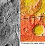
Libya Montes "face"
Libya Montes has a formation that can trigger facial pareidoliaPareidolia
Pareidolia is a psychological phenomenon involving a vague and random stimulus being perceived as significant. Common examples include seeing images of animals or faces in clouds, the man in the moon or the Moon rabbit, and hearing hidden messages on records played in reverse...
(this also happened in the Cydonia region). It can be found in the Mars Global Surveyor
Mars Global Surveyor
The Mars Global Surveyor was a US spacecraft developed by NASA's Jet Propulsion Laboratory and launched November 1996. It began the United States's return to Mars after a 10-year absence. It completed its primary mission in January 2001 and was in its third extended mission phase when, on 2...
, MOC narrow-angle image M02-03051, located here (MSSS) or here (by USGS) (Crop).