

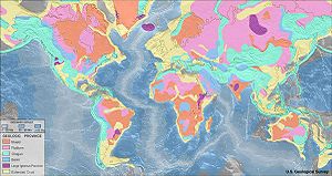
Geologic map
Encyclopedia
Map
A map is a visual representation of an area—a symbolic depiction highlighting relationships between elements of that space such as objects, regions, and themes....
made to show geological features. Rock
Rock (geology)
In geology, rock or stone is a naturally occurring solid aggregate of minerals and/or mineraloids.The Earth's outer solid layer, the lithosphere, is made of rock. In general rocks are of three types, namely, igneous, sedimentary, and metamorphic...
units or geologic strata
Stratum
In geology and related fields, a stratum is a layer of sedimentary rock or soil with internally consistent characteristics that distinguish it from other layers...
are shown by color or symbols to indicate where they are exposed at the surface. Bedding planes
Bed (geology)
In geology a bed is the smallest division of a geologic formation or stratigraphic rock series marked by well-defined divisional planes separating it from layers above and below. A bed is the smallest lithostratigraphic unit, usually ranging in thickness from a centimeter to several meters and...
and structural features such as faults, folds
Fold (geology)
The term fold is used in geology when one or a stack of originally flat and planar surfaces, such as sedimentary strata, are bent or curved as a result of permanent deformation. Synsedimentary folds are those due to slumping of sedimentary material before it is lithified. Folds in rocks vary in...
, foliations
Foliation (geology)
Foliation is any penetrative planar fabric present in rocks. Foliation is common to rocks affected by regional metamorphic compression typical of orogenic belts. Rocks exhibiting foliation include the standard sequence formed by the prograde metamorphism of mudrocks; slate, phyllite, schist and...
, and lineations are shown with strike and dip
Strike and dip
Strike and dip refer to the orientation or attitude of a geologic feature. The strike line of a bed, fault, or other planar feature is a line representing the intersection of that feature with a horizontal plane. On a geologic map, this is represented with a short straight line segment oriented...
or trend and plunge symbols which give these features' three-dimensional orientations.
Stratigraphic
Stratigraphy
Stratigraphy, a branch of geology, studies rock layers and layering . It is primarily used in the study of sedimentary and layered volcanic rocks....
contour line
Contour line
A contour line of a function of two variables is a curve along which the function has a constant value. In cartography, a contour line joins points of equal elevation above a given level, such as mean sea level...
s may be used to illustrate the surface of a selected stratum
Stratum
In geology and related fields, a stratum is a layer of sedimentary rock or soil with internally consistent characteristics that distinguish it from other layers...
illustrating the subsurface topographic
Topography
Topography is the study of Earth's surface shape and features or those ofplanets, moons, and asteroids...
trends of the strata. Isopach map
Isopach map
An isopach map is a map illustrating variation of thickness within a tabular unit or stratum. Isopachs are contour lines of equal thickness over an area. Isopach maps are utilized in hydrographic survey, stratigraphy, sedimentology, structural geology, petroleum geology and volcanology....
s detail the variations in thickness of stratigraphic units. It is not always possible to properly show this when the strata are extremely fractured, mixed, in some discontinuities, or where they are otherwise disturbed.
Lithologies
Rock units are typically represented by colors. Instead of (or in addition to) colors, certain symbols can be used. Different geologic mapping agencies and authorities have different standards for the colors and symbols to be used for rocks of differing types and ages.Orientations
Geologists take two major types of orientation measurements (using a hand compassHand compass
A hand compass is a term for any compact magnetic compass capable of one-hand use and fitted with a sighting device to record a precise bearing or azimuth to a given target or to determine a location...
like a Brunton compass
Brunton compass
A Brunton compass, properly known as the Brunton Pocket Transit, is a type of precision compass made by Brunton, Inc. of Riverton, Wyoming. The instrument was patented in 1894 by a Canadian-born Colorado geologist named David W. Brunton. Unlike most modern compasses, the Brunton Pocket Transit...
): orientations of planes and orientations of lines. Orientations of planes are often measured as a "strike" and "dip", while orientations of lines are often measured as a "trend" and "plunge".
Strike and dip symbols consist of a long "strike" line, which is perpendicular to the direction of greatest slope along the surface of the bed, and a shorter "dip" line on side of the strike line where the bed is going downwards. The angle that the bed makes with the horizontal is along the dip direction is written next to the dip line. In the azimuthal system, strike and dip are often given as "STRIKE / DIP" (for example: 347/15, for a strike that is slightly West of North and a dip of 15 degrees below the horizontal).
Trend and plunge are used for linear features, and their symbol is a single arrow on the map. The arrow is oriented in the downgoing direction of the linear feature (the "trend") an at the end of the arrow, the number of degrees that the feature lies below the horizontal (the "plunge") is noted. Trend and plunge are often notated as PLUNGE → TREND (for example: 34 → 86 indicates a feature that is angled at 34 degrees below the horizontal at an angle that is just East of true South).
History
The oldest preserved geologic map is the Turin papyrusTurin Papyrus
Turin Papyrus refers to any papyrus manuscript in the collection of the Museo Egizio at Turin, Italy. The best known of these manuscripts include:* Turin Papyrus Map* Turin King List* Judicial Papyrus of Turin* Turin Erotic Papyrus...
, made around 1150 BCE for gold
Gold
Gold is a chemical element with the symbol Au and an atomic number of 79. Gold is a dense, soft, shiny, malleable and ductile metal. Pure gold has a bright yellow color and luster traditionally considered attractive, which it maintains without oxidizing in air or water. Chemically, gold is a...
deposits in Egypt.
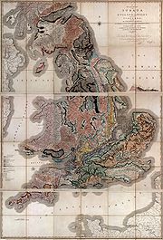
The first geologic map of Great Britain
Great Britain
Great Britain or Britain is an island situated to the northwest of Continental Europe. It is the ninth largest island in the world, and the largest European island, as well as the largest of the British Isles...
was created by William Smith
William Smith (geologist)
William 'Strata' Smith was an English geologist, credited with creating the first nationwide geological map. He is known as the "Father of English Geology" for collating the geological history of England and Wales into a single record, although recognition was very slow in coming...
in 1815.
Maps and mapping across the globe

United States
In the United StatesUnited States
The United States of America is a federal constitutional republic comprising fifty states and a federal district...
, geologic maps are usually superimposed over a topographic map
Topographic map
A topographic map is a type of map characterized by large-scale detail and quantitative representation of relief, usually using contour lines in modern mapping, but historically using a variety of methods. Traditional definitions require a topographic map to show both natural and man-made features...
(and at times over other base maps) with the addition of a color mask with letter symbols to represent the kind of geologic unit
Geologic unit
A geological unit is a volume of rock or ice of identifiable origin and age range that is defined by the distinctive and dominant, easily mapped and recognizable petrographic, lithologic or paleontologic features that characterize it....
. The color mask denotes the exposure of the immediate bedrock
Bedrock
In stratigraphy, bedrock is the native consolidated rock underlying the surface of a terrestrial planet, usually the Earth. Above the bedrock is usually an area of broken and weathered unconsolidated rock in the basal subsoil...
, even if obscured by soil or other cover. Each area of color denotes a geologic unit or particular rock
Rock (geology)
In geology, rock or stone is a naturally occurring solid aggregate of minerals and/or mineraloids.The Earth's outer solid layer, the lithosphere, is made of rock. In general rocks are of three types, namely, igneous, sedimentary, and metamorphic...
formation (as more information is gathered new geologic units may be defined). However, in areas where the bedrock is overlain by a significantly thick unconsolidated burden of till
Till
thumb|right|Closeup of glacial till. Note that the larger grains in the till are completely surrounded by the matrix of finer material , and this characteristic, known as matrix support, is diagnostic of till....
, terrace sedimentss, loess
Loess
Loess is an aeolian sediment formed by the accumulation of wind-blown silt, typically in the 20–50 micrometre size range, twenty percent or less clay and the balance equal parts sand and silt that are loosely cemented by calcium carbonate...
deposits, or other important feature, these are shown instead. Stratigraphic
Stratigraphy
Stratigraphy, a branch of geology, studies rock layers and layering . It is primarily used in the study of sedimentary and layered volcanic rocks....
contour lines, fault lines, strike and dip symbols, are represented with various symbols as indicated by the map key. Whereas topographic maps are produced by the United States Geological Survey
United States Geological Survey
The United States Geological Survey is a scientific agency of the United States government. The scientists of the USGS study the landscape of the United States, its natural resources, and the natural hazards that threaten it. The organization has four major science disciplines, concerning biology,...
in conjunction with the states, geologic maps are usually produced by the individual states. There are almost no geologic map resources for some states, while a few states, such as Kentucky
Kentucky
The Commonwealth of Kentucky is a state located in the East Central United States of America. As classified by the United States Census Bureau, Kentucky is a Southern state, more specifically in the East South Central region. Kentucky is one of four U.S. states constituted as a commonwealth...
, are extensively mapped geologically.
United Kingdom
In the United KingdomUnited Kingdom
The United Kingdom of Great Britain and Northern IrelandIn the United Kingdom and Dependencies, other languages have been officially recognised as legitimate autochthonous languages under the European Charter for Regional or Minority Languages...
the term geological map is used. The UK and Isle of Man
Isle of Man
The Isle of Man , otherwise known simply as Mann , is a self-governing British Crown Dependency, located in the Irish Sea between the islands of Great Britain and Ireland, within the British Isles. The head of state is Queen Elizabeth II, who holds the title of Lord of Mann. The Lord of Mann is...
have been extensively mapped by the British Geological Survey
British Geological Survey
The British Geological Survey is a partly publicly funded body which aims to advance geoscientific knowledge of the United Kingdom landmass and its continental shelf by means of systematic surveying, monitoring and research. The BGS headquarters are in Keyworth, Nottinghamshire, but other centres...
since 1835; a separate Geological Survey of Northern Ireland (drawing on BGS staff) has operated since 1947.
Two 1:625,000 scale maps cover the basic geology for the UK. More detailed sheets are available at scales of 1:250,000, 1:50,000 and 1:10,000. The 1:625,000 and 1:250,000 scales show both onshore and offshore geology (the 1:250,000 series covers the entire UK continental shelf
Continental shelf
The continental shelf is the extended perimeter of each continent and associated coastal plain. Much of the shelf was exposed during glacial periods, but is now submerged under relatively shallow seas and gulfs, and was similarly submerged during other interglacial periods. The continental margin,...
), whilst other scales generally cover exposures on land only.
Sheets of all scales (though not for all areas) fall into two categories:
-
-
- Superficial depositSuperficial depositsSuperficial deposits refer to geological deposits typically of Quaternary age. These recent unconsolidated sediments may include stream channel and floodplain deposits, beach sands, talus gravels and glacial drift and moraine...
maps (previously known as solid and drift maps) show both bedrock and the deposits on top of it. - BedrockBedrockIn stratigraphy, bedrock is the native consolidated rock underlying the surface of a terrestrial planet, usually the Earth. Above the bedrock is usually an area of broken and weathered unconsolidated rock in the basal subsoil...
maps (previously known as solid maps) show the underlying rock, without superficial deposits.
- Superficial deposit
-
The maps are superimposed over a topographic map base produced by Ordnance Survey
Ordnance Survey
Ordnance Survey , an executive agency and non-ministerial government department of the Government of the United Kingdom, is the national mapping agency for Great Britain, producing maps of Great Britain , and one of the world's largest producers of maps.The name reflects its creation together with...
, and use symbols to represent fault lines, strike and dip or geological units, borehole
Borehole
A borehole is the generalized term for any narrow shaft bored in the ground, either vertically or horizontally. A borehole may be constructed for many different purposes, including the extraction of water or other liquid or gases , as part of a geotechnical investigation, environmental site...
s etc. Colors are used to represent different geological units. Explanatory booklets (memoirs) are produced for many sheets at the 1:50,000 scale.
Small scale thematic map
Thematic map
A thematic map is a type of map or chart especially designed to show a particular theme connected with a specific geographic area. These maps "can portray physical, social, political, cultural, economic, sociological, agricultural, or any other aspects of a city, state, region,nation , or...
s (1:1,000,000 to 1:100,000) are also produced covering geochemistry
Geochemistry
The field of geochemistry involves study of the chemical composition of the Earth and other planets, chemical processes and reactions that govern the composition of rocks, water, and soils, and the cycles of matter and energy that transport the Earth's chemical components in time and space, and...
, gravity anomaly
Gravity anomaly
A gravity anomaly is the difference between the observed acceleration of Earth's gravity and a value predicted from a model.-Geodesy and geophysics:...
, magnetic anomaly
Magnetic anomaly
In geophysics, a magnetic anomaly is a local variation in the Earth's magnetic field resulting from variations in the chemistry or magnetism of the rocks. Mapping of variation over an area is valuable in detecting structures obscured by overlying material...
, groundwater
Groundwater
Groundwater is water located beneath the ground surface in soil pore spaces and in the fractures of rock formations. A unit of rock or an unconsolidated deposit is called an aquifer when it can yield a usable quantity of water. The depth at which soil pore spaces or fractures and voids in rock...
, etc.
Although BGS maps show the National Grid
British national grid reference system
The Ordnance Survey National Grid reference system is a system of geographic grid references used in Great Britain, different from using latitude and longitude....
and employ an OS base map, sheet boundaries are not based on the grid. The 1:50,000 sheets originate from earlier 'one inch to the mile' (1:63,630) coverage utilising the pre-grid Ordnance Survey One Inch Third Edition as the base map. Current sheets are a mixture of modern field mapping at 1:10,000 redrawn at the 1:50,000 scale and older 1:63,630 maps reproduced on a modern base map at 1:50,000. In both cases the original OS Third Edition sheet margins and numbers are retained. The 1:250,000 sheets are defined using lines of latitude and longitude, each extending 1° north-south and 2° east-west.
Singapore
The first geologic map of Singapore was produced in 1974, produced by the then Public Work Department. The publication include a locality map, 8 map sheets detailing the topography and geological units, and a sheet containing cross sections of the island.Since 1974, for 30 years, there were many finding reported in various technical conferences on new found geology islandwide, but no new publication was produced. In 2006, Defence Science & Technology Agency, with their developments in underground space
promptly started a re-publication of the Geology of Singapore, second edition. The new edition that was published in 2009, contains a 1:75,000 geology map of the island, 6 maps (1:25,000) containing topography, street directory and geology, a sheet of cross section and a locality map.
The difference found between the 1976 Geology of Singapore report include numerous formations found in literature between 1976 and 2009. These include the Fort Canning Boulder Beds and stretches of limestones.
See also
- GeologyGeologyGeology is the science comprising the study of solid Earth, the rocks of which it is composed, and the processes by which it evolves. Geology gives insight into the history of the Earth, as it provides the primary evidence for plate tectonics, the evolutionary history of life, and past climates...
- GeographyGeographyGeography is the science that studies the lands, features, inhabitants, and phenomena of Earth. A literal translation would be "to describe or write about the Earth". The first person to use the word "geography" was Eratosthenes...
- CartographyCartographyCartography is the study and practice of making maps. Combining science, aesthetics, and technique, cartography builds on the premise that reality can be modeled in ways that communicate spatial information effectively.The fundamental problems of traditional cartography are to:*Set the map's...
- OneGeologyOneGeologyOneGeology is an international collaborative project in the field of geology supported by 113 countries, UNESCO and major global geoscience bodies. It is an International Year of Planet Earth flagship initiative that aims to enable online access to dynamic digital geological map of the world for...
- Digital geologic mappingDigital geologic mappingDigital geologic mapping is the process by which geologic features are observed, analyzed, and recorded in the field and displayed in real-time on a computer or personal digital assistant...
External links
- Geologic Maps from USGS National Park Service
- USGS National Geologic Map Database