

Valley networks (Mars)
Encyclopedia
Valley networks are branching networks of valleys on Mars
that superficially resemble terrestrial river
drainage basins
. They are found mainly incised
into the terrain of the martian southern highlands, and are typically - though not always - of Noachian
age (approximately four billion years old). The individual valleys are typically less than 5 kilometers wide, though they may extend for up to hundreds or even thousands of kilometers across the martian surface.
The form, distribution, and implied evolution of the valley networks are of great importance for what they may tell us about the history of liquid water
on the martian surface, and hence Mars' climate
history. Some authors have argued that the properties of the networks demand that a hydrological cycle must have been active on ancient Mars, though this remains contentious. Objections chiefly arise from repeated results from models of martian paleoclimate
suggesting high enough temperatures and pressures to sustain liquid water on the surface have not ever been possible on Mars.
The advent of very high resolution images of the surface from the HiRISE
, THEMIS
and Context
(CTX) satellite cameras as well as the Mars Orbital Laser Altimeter (MOLA) digital terrain models have drastically improved our understanding of the networks in the last decade.
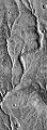 The valleys of the networks are typically narrow (<0.5-4 km) and 50-200 m deep, with neither value changing consistently along their lengths. Their cross-sectional form tends to evolve from V-shaped in the headwaters to U-shaped in the lower reaches. The individual valleys form interconnected branching networks, typically less than 200km long and draining into local topographic lows.. The form of the tributary valleys is commonly described as "stubby" or a similar term, implying short lengths away from the trunk streams and amphitheater-like terminations at their heads. Many authors have described the drainage density
of the networks as typically much lower than would be seen on Earth, though the extent to which this may an artifact of image resolution, landscape degradation or observer bias has also been raised in the literature.
However, more recent imagery has also emphasized that the term "valley network" incorporates a large variety of different valley forms across a number of different scales in different martian geological settings. Any branched valley system on a scale smaller than an outflow channel can be termed a valley network, probably incorporating a large variety of geomorphological
formation processes. Some valley networks run for over 2000 km across the martian landscape. Some may change width downstream. Some have drainage densities which do match some terrestrial values. Narrower, less deep valley networks are present, but probably are more rare than their larger equivalents.
In most valley networks, later aeolian processes have deposited wind-blown sediments in the bottoms of the valleys, obscuring the nature of the channel which must have cut them. On Earth, a valley is a depression with a flat floor, across which migrates a channel, which carries the water discharge. Due to the later deposits on Mars, however, in almost all cases it is unclear whether the valley floors contain individual channel structures or whether they are fully inundated in flow events. Nanedi Valles
is a rare example where a channel has been identified, though new higher resolution imagery again continues to reveal more such structures with time. This accounts for the preference in the literature for the term "valley network" rather than "channel network", though some work tends to confuse the two in interpretation of these structures.
-age lava
plains of the northern hemisphere are in general almost entirely undissected. However, there are significant numbers of exceptions to this generalization - in particular, many of the Hesperian and younger volcanoes
carry networks, as well as several other areas. These valleys also appear qualitatively "fresher" and less degraded than those in the highlands (e.g., Nanedi Vallis).
However, at finer scales than this the distribution of the valleys where present is highly patchy and discontinuous. Within the highlands, it is not unusual to find heavily dissected slopes immediately adjacent to almost entirely unmodified surfaces, both at valley and catchment scales. The valleys are also regionally clustered, with little dissection in Northwest Arabia
and southwest and southeast of Hellas
, but much in Terra Cimmeria
and just south of the equator from 20°E to 180°E. They are also much more prominent on steeper slopes, for example on crater rims, but again may only be present on one side of such a rim.
Unfortunately, the generally small size of individual catchments and the relative narrowness of their constituent valleys means that dating the valley networks by conventional crater counting
techniques is extremely difficult (though not impossible). The concentration of the valleys in the Noachian
-age southern highlands and their sparsity on the northern Hesperian plains, circumstantially combined with independent estimates of a multi-order of magnitude decrease in global martian erosion rates at the end of the Noachian, probably indicates that most of the networks were cut during this early interval. However, the channels on Hesperian surfaces unambiguously demonstrate that valley-forming processes did continue at least in some locations at least some of the time after the Noachian. Some crater counting evidence even suggests some highland networks may have formed in the Amazonian.
) that almost uniquely allow it to flow thousands of kilometers downhill as streams. Channel features on what are interpreted as eroded deltas at the foot of some networks (e.g., in Eberswalde crater
) are also uniquely associated with formation by flowing water - for example, meandering, sinuous channels with meander cutoffs, which have internally consistent hydraulic geometries corresponding very closely to what would be expected in fluvial channels on Earth. Independent lines of evidence also suggest the existence of liquid water at or very near the surface at various times in martian history, for example, evaporites at Meridiani Planum
and pervasive aqueous alteration of rocks in the Columbia Hills, both investigated by the Mars Exploration Rovers.
Beyond this, there are several different scenarios that have been advanced to account for the form and distribution in both space and time of the valleys. Each has its own set of implications regarding the paleoclimate of Mars at the time of formation of the networks. Some of these are summarized below. It is also worth emphasizing that, as on Earth, different formation mechanisms are likely to operate at different times and places on the surface of Mars.
insulates the molten lava inside it.
The valleys typically have many features that on Earth are commonly (though not exclusively) associated with groundwater sapping
- for instance, amphitheater-like headwalls, constant valley width downstream, flat or U-shaped floors and steep walls. However, without some recharge mechanism for the putative aquifers producing this seepage, i.e., a hydrologic cycle of some kind, it is extremely unlikely that enough water could seep to cut all of the valleys formed in the Noachian. In spite of this, this basic model may remain useful in understanding the more limited valleys formed later in the Hesperian and Amazonian.
. This means Mars need not be warm (i.e., above freezing) in its early history, in accordance with current climate models.
could be recharged on geological time scales by a sequence of sublimation of the frozen seeps, atmospheric circulation of the vapor to the southern polar ice cap, redeposition of this onto the cap, basal melting under the ice mass, and groundwater circulation on a global scale. This mechanism is appealing as it requires little conjecture about radically different past climate, and fits well with independent theories on the origins of the martian outflow channels
at chaos terrains
as major aquifer breaches. However, the hydrostatic head
supplied by this mechanism could not feed the numerous channels at elevations greater than the base of the southern polar cap.
or snow
(with subsequent melt on the ground), but either demands a significantly more humid, and thus warmer and thicker, atmosphere than presently exists. A warmer, wetter Noachian is also supported by independent observations of rock weathering rates, Noachian-age crater lakes
, and Noachian geology at the lander sites.
The chief difficulty with this model is that no martian climate simulation can reliably simulate a warm, wet Noachian, largely due to the distance between the sun and Mars compared to the Earth, and the inferred weaker Sun in the early solar system. Furthermore, a CO2-H2O greenhouse atmosphere to warm the climate should have left extensive deposits of carbonate
rocks, which have not been found. Problems also exist with sustaining such an atmosphere for long enough to allow the valleys to form, as the unweathered basalts so prevalent on Mars should form extremely effective carbon sinks, especially if the surface is wet, and continuing impacts from space in Mars' early history should quickly strip any atmosphere away.
Solutions to this apparent contradiction may include exotic mechanisms that do not require a sustained CO2-H2O greenhouse, such as episodic heating due to volcanism or impacts. Other possibilities (other than misinterpretation of the geology and geomorphology) are defects in the physics of, or boundary conditions for, the climate models - a stronger Sun than current theory predicts, defective assumptions about trace (but powerful) greenhouse gases, or failings in the parameterization of CO2 clouds.
Mars
Mars is the fourth planet from the Sun in the Solar System. The planet is named after the Roman god of war, Mars. It is often described as the "Red Planet", as the iron oxide prevalent on its surface gives it a reddish appearance...
that superficially resemble terrestrial river
River
A river is a natural watercourse, usually freshwater, flowing towards an ocean, a lake, a sea, or another river. In a few cases, a river simply flows into the ground or dries up completely before reaching another body of water. Small rivers may also be called by several other names, including...
drainage basins
Drainage basin
A drainage basin is an extent or an area of land where surface water from rain and melting snow or ice converges to a single point, usually the exit of the basin, where the waters join another waterbody, such as a river, lake, reservoir, estuary, wetland, sea, or ocean...
. They are found mainly incised
Erosion
Erosion is when materials are removed from the surface and changed into something else. It only works by hydraulic actions and transport of solids in the natural environment, and leads to the deposition of these materials elsewhere...
into the terrain of the martian southern highlands, and are typically - though not always - of Noachian
Noachian
The Noachian is a geologic system and early time period on the planet Mars characterized by high rates of meteorite and asteroid impacts and the presence of abundant surface water...
age (approximately four billion years old). The individual valleys are typically less than 5 kilometers wide, though they may extend for up to hundreds or even thousands of kilometers across the martian surface.
The form, distribution, and implied evolution of the valley networks are of great importance for what they may tell us about the history of liquid water
Water on Mars
Water on Mars is a psychedelic rock and electronic music group from Quebec City, Québec, Canada. The music trio is led by Philippe Navarro, guitarist, vocalist, arranger, producer, principal lyricist, and music composer....
on the martian surface, and hence Mars' climate
Climate
Climate encompasses the statistics of temperature, humidity, atmospheric pressure, wind, rainfall, atmospheric particle count and other meteorological elemental measurements in a given region over long periods...
history. Some authors have argued that the properties of the networks demand that a hydrological cycle must have been active on ancient Mars, though this remains contentious. Objections chiefly arise from repeated results from models of martian paleoclimate
Climate of Mars
The climate of Mars has been an issue of scientific curiosity for centuries, not least because Mars is the only terrestrial planet whose surface can be directly observed in detail from the Earth....
suggesting high enough temperatures and pressures to sustain liquid water on the surface have not ever been possible on Mars.
The advent of very high resolution images of the surface from the HiRISE
HiRISE
High Resolution Imaging Science Experiment is a camera on board the Mars Reconnaissance Orbiter. The 65 kg , $40 million instrument was built under the direction of the University of Arizona's Lunar and Planetary Laboratory by Ball Aerospace & Technologies Corp....
, THEMIS
Thermal Emission Imaging System
The Thermal Emission Imaging System is a camera on board the 2001 Mars Odyssey orbiter. It images Mars in the visible and infrared parts of the electromagnetic spectrum in order to determine the thermal properties of the surface and to refine the distribution of minerals on the surface of Mars as...
and Context
Mars Reconnaissance Orbiter
Mars Reconnaissance Orbiter is a NASA multipurpose spacecraft designed to conduct reconnaissance and Exploration of Mars from orbit...
(CTX) satellite cameras as well as the Mars Orbital Laser Altimeter (MOLA) digital terrain models have drastically improved our understanding of the networks in the last decade.
Form
Drainage density
Drainage density is the total length of all the streams and rivers in a drainage basin divided by the total area of the drainage basin. It is a measure of how well or how poorly a watershed is drained by stream channels...
of the networks as typically much lower than would be seen on Earth, though the extent to which this may an artifact of image resolution, landscape degradation or observer bias has also been raised in the literature.
However, more recent imagery has also emphasized that the term "valley network" incorporates a large variety of different valley forms across a number of different scales in different martian geological settings. Any branched valley system on a scale smaller than an outflow channel can be termed a valley network, probably incorporating a large variety of geomorphological
Geomorphology
Geomorphology is the scientific study of landforms and the processes that shape them...
formation processes. Some valley networks run for over 2000 km across the martian landscape. Some may change width downstream. Some have drainage densities which do match some terrestrial values. Narrower, less deep valley networks are present, but probably are more rare than their larger equivalents.
In most valley networks, later aeolian processes have deposited wind-blown sediments in the bottoms of the valleys, obscuring the nature of the channel which must have cut them. On Earth, a valley is a depression with a flat floor, across which migrates a channel, which carries the water discharge. Due to the later deposits on Mars, however, in almost all cases it is unclear whether the valley floors contain individual channel structures or whether they are fully inundated in flow events. Nanedi Valles
Nanedi Valles
Nanedi Valles is a large valley in the Lunae Palus quadrangle of Mars, located at4.9° N and 49.0° W. It is 508.0 km long and was named for the word for "planet" in Sesotho, the national language of Lesotho, Africa....
is a rare example where a channel has been identified, though new higher resolution imagery again continues to reveal more such structures with time. This accounts for the preference in the literature for the term "valley network" rather than "channel network", though some work tends to confuse the two in interpretation of these structures.
Distribution and Age
Valley networks are very strongly concentrated in the cratered southern uplands of Mars. The HesperianHesperian
The Hesperian is a geologic system and time period on the planet Mars characterized by widespread volcanic activity and catastrophic flooding that carved immense outflow channels across the surface. The Hesperian is an intermediate and transitional period of Martian history...
-age lava
Lava
Lava refers both to molten rock expelled by a volcano during an eruption and the resulting rock after solidification and cooling. This molten rock is formed in the interior of some planets, including Earth, and some of their satellites. When first erupted from a volcanic vent, lava is a liquid at...
plains of the northern hemisphere are in general almost entirely undissected. However, there are significant numbers of exceptions to this generalization - in particular, many of the Hesperian and younger volcanoes
Volcanism on Mars
Volcanic activity, or volcanism, has played a significant role in the geologic evolution of Mars. Scientists have known since the Mariner 9 mission in 1972 that volcanic features cover large portions of the Martian surface. These features include extensive lava flows, vast volcanic plains, and the...
carry networks, as well as several other areas. These valleys also appear qualitatively "fresher" and less degraded than those in the highlands (e.g., Nanedi Vallis).
However, at finer scales than this the distribution of the valleys where present is highly patchy and discontinuous. Within the highlands, it is not unusual to find heavily dissected slopes immediately adjacent to almost entirely unmodified surfaces, both at valley and catchment scales. The valleys are also regionally clustered, with little dissection in Northwest Arabia
Arabia Terra
Arabia Terra is a large upland region in the north of Mars in that lies mostly in the Arabia quadrangle. It is densely cratered and heavily eroded. This battered topography indicates great age, and Arabia Terra is presumed to be one of the oldest terrains on the planet...
and southwest and southeast of Hellas
Hellas Planitia
Hellas Planitia, also known as the Hellas Impact Basin, is a huge, roughly circular impact basin located in the southern hemisphere of the planet Mars. It is the second or third largest impact crater and the largest visible impact crater known in the Solar System...
, but much in Terra Cimmeria
Terra Cimmeria
Terra Cimmeria is a large Martian region, centered at and covering 5400 km at its broadest extent. It covers latitudes 15 N to 75 S and longitudes 170 to 260 W. Terra Cimmeria is one part of the heavily cratered, southern highland region of the planet...
and just south of the equator from 20°E to 180°E. They are also much more prominent on steeper slopes, for example on crater rims, but again may only be present on one side of such a rim.
Unfortunately, the generally small size of individual catchments and the relative narrowness of their constituent valleys means that dating the valley networks by conventional crater counting
Crater counting
Crater counting is a method for estimating the age of a planet's surface. The method is based upon the assumptions that a new surface forms with zero impact craters, and that impact craters accumulate at some constant rate...
techniques is extremely difficult (though not impossible). The concentration of the valleys in the Noachian
Noachian
The Noachian is a geologic system and early time period on the planet Mars characterized by high rates of meteorite and asteroid impacts and the presence of abundant surface water...
-age southern highlands and their sparsity on the northern Hesperian plains, circumstantially combined with independent estimates of a multi-order of magnitude decrease in global martian erosion rates at the end of the Noachian, probably indicates that most of the networks were cut during this early interval. However, the channels on Hesperian surfaces unambiguously demonstrate that valley-forming processes did continue at least in some locations at least some of the time after the Noachian. Some crater counting evidence even suggests some highland networks may have formed in the Amazonian.
Formation and implications for martian climate history
Mechanisms and implied environments for the formation of the valleys remain contentious. Processes as diverse as glaciation, mass wasting, faulting, and erosion by CO2, wind and lava have all been invoked at some point in the formation of some networks, and may play important roles locally in some regions on Mars. Most authors however agree that liquid water must have played a role in the formation of the bulk of the valleys, largely on the basis of both the known widespread distribution of ice on Mars and also the physical properties of liquid water (e.g., viscosityViscosity
Viscosity is a measure of the resistance of a fluid which is being deformed by either shear or tensile stress. In everyday terms , viscosity is "thickness" or "internal friction". Thus, water is "thin", having a lower viscosity, while honey is "thick", having a higher viscosity...
) that almost uniquely allow it to flow thousands of kilometers downhill as streams. Channel features on what are interpreted as eroded deltas at the foot of some networks (e.g., in Eberswalde crater
Eberswalde (crater)
Eberswalde, formerly known as Holden NE, is a partially buried impact crater in Margaritifer Terra, Mars. Eberswalde Crater lies just to the north of Holden Crater, a large crater that may have been a lake...
) are also uniquely associated with formation by flowing water - for example, meandering, sinuous channels with meander cutoffs, which have internally consistent hydraulic geometries corresponding very closely to what would be expected in fluvial channels on Earth. Independent lines of evidence also suggest the existence of liquid water at or very near the surface at various times in martian history, for example, evaporites at Meridiani Planum
Meridiani Planum
Meridiani Planum is a plain located 2 degrees south of Mars' equator , in the westernmost portion of Terra Meridiani. It hosts a rare occurrence of gray crystalline hematite...
and pervasive aqueous alteration of rocks in the Columbia Hills, both investigated by the Mars Exploration Rovers.
Beyond this, there are several different scenarios that have been advanced to account for the form and distribution in both space and time of the valleys. Each has its own set of implications regarding the paleoclimate of Mars at the time of formation of the networks. Some of these are summarized below. It is also worth emphasizing that, as on Earth, different formation mechanisms are likely to operate at different times and places on the surface of Mars.
1. Business as usual, groundwater under ice: Cold, dry Mars
This scenario seeks to describe the formation of the valley networks without appeal to conditions or processes different to those already known to exist on Mars today. Modeling indicates that seeps of groundwater could occur on the surface even under modern conditions, but will freeze very quickly. However, under this suggestion ice cover could insulate the water flowing beneath it well enough to allow long distance transport (and associated erosion), much like a lava tubeLava tube
Lava tubes are natural conduits through which lava travels beneath the surface of a lava flow, expelled by a volcano during an eruption. They can be actively draining lava from a source, or can be extinct, meaning the lava flow has ceased and the rock has cooled and left a long, cave-like...
insulates the molten lava inside it.
The valleys typically have many features that on Earth are commonly (though not exclusively) associated with groundwater sapping
Groundwater sapping
Groundwater sapping is the geomorphic process in which groundwater exits a bank or hillslope laterally as seeps and springs and erodes soil from the slope. This often causes the slope to be undermined and undergo mass wasting, hence the word sapping....
- for instance, amphitheater-like headwalls, constant valley width downstream, flat or U-shaped floors and steep walls. However, without some recharge mechanism for the putative aquifers producing this seepage, i.e., a hydrologic cycle of some kind, it is extremely unlikely that enough water could seep to cut all of the valleys formed in the Noachian. In spite of this, this basic model may remain useful in understanding the more limited valleys formed later in the Hesperian and Amazonian.
2. Groundwater sources, hydrological cycle: Cold, wet Mars
These models expand upon the cold, dry Mars model by envisioning mechanisms whereby subsurface aquifers providing groundwater might be recharged in early Mars history. They thus require a sustained water cycle of some sort on the long term in the Noachian, but do not explicitly require that this water be liquid or fall as precipitationPrecipitation (meteorology)
In meteorology, precipitation In meteorology, precipitation In meteorology, precipitation (also known as one of the classes of hydrometeors, which are atmospheric water phenomena is any product of the condensation of atmospheric water vapor that falls under gravity. The main forms of precipitation...
. This means Mars need not be warm (i.e., above freezing) in its early history, in accordance with current climate models.
Global groundwater circulation
It has been proposed that the aquifersAquifer
An aquifer is a wet underground layer of water-bearing permeable rock or unconsolidated materials from which groundwater can be usefully extracted using a water well. The study of water flow in aquifers and the characterization of aquifers is called hydrogeology...
could be recharged on geological time scales by a sequence of sublimation of the frozen seeps, atmospheric circulation of the vapor to the southern polar ice cap, redeposition of this onto the cap, basal melting under the ice mass, and groundwater circulation on a global scale. This mechanism is appealing as it requires little conjecture about radically different past climate, and fits well with independent theories on the origins of the martian outflow channels
Outflow channels
Outflow channels is the term used to describe extremely long, wide swathes of scoured ground on Mars, commonly containing the streamlined remnants of pre-existing topography and other linear erosive features indicating sculpting by fluids moving downslope...
at chaos terrains
Chaos terrain
Chaos terrain is an astrogeological term used to denote planetary surface areas where features such as ridges, cracks, and plains appear jumbled and enmeshed with one another. Chaos terrain is a notable feature of the planet Mars and Jupiter's moon Europa...
as major aquifer breaches. However, the hydrostatic head
Hydrostatic head
When generating hydropower, the head is a general term used to describe the distance that a given water source has to fall before the point where power is generated. Ultimately the force responsible for hydropower is gravity, so a hydroelectricity plant with a tall/high head can produce more...
supplied by this mechanism could not feed the numerous channels at elevations greater than the base of the southern polar cap.
Local groundwater circulation
A related model suggests that locally generated heat could produce local scale groundwater seepage and recharge, either by intrusive volcanism or impact heating. However, this version struggles to explain the longer, larger valley networks - if water flows hundreds or thousands of kilometers away from the heat source, ground will again be frozen and recharge will not be possible once again.3. Full active hydrological cycle: Warm, wet Mars
Many of the Noachian valley networks have features strongly indicative of an origin from distributed precipitation: branched networks, valleys starting at narrow crests, V-shaped cross profiles, diffusional behavior of hillslopes. Conversely, using only geomorphic evidence, it is very challenging to build a strong argument against origin by precipitation. Precipitation also provides a straightforward recharge mechanism for subsurface aquifers, which doubtlessly do exist and are important in some cases (as on Earth). This precipitation may have occurred as rainRain
Rain is liquid precipitation, as opposed to non-liquid kinds of precipitation such as snow, hail and sleet. Rain requires the presence of a thick layer of the atmosphere to have temperatures above the melting point of water near and above the Earth's surface...
or snow
Snow
Snow is a form of precipitation within the Earth's atmosphere in the form of crystalline water ice, consisting of a multitude of snowflakes that fall from clouds. Since snow is composed of small ice particles, it is a granular material. It has an open and therefore soft structure, unless packed by...
(with subsequent melt on the ground), but either demands a significantly more humid, and thus warmer and thicker, atmosphere than presently exists. A warmer, wetter Noachian is also supported by independent observations of rock weathering rates, Noachian-age crater lakes
Crater lake
A crater lake is a lake that forms in a volcanic crater or caldera, such as a maar; less commonly and with lower association to the term a lake may form in an impact crater caused by a meteorite. Sometimes lakes which form inside calderas are called caldera lakes, but often this distinction is not...
, and Noachian geology at the lander sites.
The chief difficulty with this model is that no martian climate simulation can reliably simulate a warm, wet Noachian, largely due to the distance between the sun and Mars compared to the Earth, and the inferred weaker Sun in the early solar system. Furthermore, a CO2-H2O greenhouse atmosphere to warm the climate should have left extensive deposits of carbonate
Carbonate
In chemistry, a carbonate is a salt of carbonic acid, characterized by the presence of the carbonate ion, . The name may also mean an ester of carbonic acid, an organic compound containing the carbonate group C2....
rocks, which have not been found. Problems also exist with sustaining such an atmosphere for long enough to allow the valleys to form, as the unweathered basalts so prevalent on Mars should form extremely effective carbon sinks, especially if the surface is wet, and continuing impacts from space in Mars' early history should quickly strip any atmosphere away.
Solutions to this apparent contradiction may include exotic mechanisms that do not require a sustained CO2-H2O greenhouse, such as episodic heating due to volcanism or impacts. Other possibilities (other than misinterpretation of the geology and geomorphology) are defects in the physics of, or boundary conditions for, the climate models - a stronger Sun than current theory predicts, defective assumptions about trace (but powerful) greenhouse gases, or failings in the parameterization of CO2 clouds.