
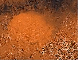
Hellas Planitia
Encyclopedia

Plain
In geography, a plain is land with relatively low relief, that is flat or gently rolling. Prairies and steppes are types of plains, and the archetype for a plain is often thought of as a grassland, but plains in their natural state may also be covered in shrublands, woodland and forest, or...
, also known as the Hellas Impact Basin, is a huge, roughly circular impact basin located in the southern hemisphere
Sphere
A sphere is a perfectly round geometrical object in three-dimensional space, such as the shape of a round ball. Like a circle in two dimensions, a perfect sphere is completely symmetrical around its center, with all points on the surface lying the same distance r from the center point...
of the planet
Planet
A planet is a celestial body orbiting a star or stellar remnant that is massive enough to be rounded by its own gravity, is not massive enough to cause thermonuclear fusion, and has cleared its neighbouring region of planetesimals.The term planet is ancient, with ties to history, science,...
Mars
Mars
Mars is the fourth planet from the Sun in the Solar System. The planet is named after the Roman god of war, Mars. It is often described as the "Red Planet", as the iron oxide prevalent on its surface gives it a reddish appearance...
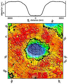
. It is the second or third largest impact crater and the largest visible impact crater known in the Solar System. The basin floor is about 7152-meters deep, 3 km deeper than the moon's South Pole-Aitken basin
South Pole-Aitken basin
The South Pole-Aitken basin is an impact crater on Earth's Moon. Roughly in diameter and deep, it is one of the largest known impact craters in the Solar System. It is the largest, oldest and deepest basin recognized on the Moon. This moon basin was named for two features on opposing sides; the...
, and extends about 2,300 km east to west. It is centered at 42.7°S 70°E
Description
With a diameterDiameter
In geometry, a diameter of a circle is any straight line segment that passes through the center of the circle and whose endpoints are on the circle. The diameters are the longest chords of the circle...
of about 2300 kilometres (1,429.2 mi), it is the largest unambiguous impact structure on the planet, though a distant second if the Borealis Basin
North Polar Basin (Mars)
The North Polar Basin, or Borealis basin, is a large basin in the northern hemisphere of Mars that covers 40% of the planet. Chryse Planitia, the landing site of the Viking 1 lander, is a bay which opens into this basin....
proves to be an impact crater. The basin is thought to have been formed during the Late Heavy Bombardment
Late Heavy Bombardment
The Late Heavy Bombardment is a period of time approximately 4.1 to 3.8 billion years ago during which a large number of impact craters are believed to have formed on the Moon, and by inference on Earth, Mercury, Venus, and Mars as well...
period of the Solar System
Solar System
The Solar System consists of the Sun and the astronomical objects gravitationally bound in orbit around it, all of which formed from the collapse of a giant molecular cloud approximately 4.6 billion years ago. The vast majority of the system's mass is in the Sun...
, approximately 4.1 to 3.8 billion years ago, when a large asteroid hit the surface.
The altitude difference between the rim
Rim (craters)
The rim of a crater is the part that extends above the height of the local surface, usually in a circular or elliptical pattern. In a more specific sense, the rim may refer to the circular or elliptical edge that represents the uppermost tip of this raised portion...
and the bottom is ~9 km (30,000 ft). The depth of the crater (7152-meters (23,000 ft) below the standard topographic datum of Mars) explains the atmospheric pressure at the bottom: 1,155 Pa
Pascal (unit)
The pascal is the SI derived unit of pressure, internal pressure, stress, Young's modulus and tensile strength, named after the French mathematician, physicist, inventor, writer, and philosopher Blaise Pascal. It is a measure of force per unit area, defined as one newton per square metre...
(11.55 mbar, 0.17 psi, or 0.01 atm). This is 89% higher than the pressure at the topographical datum (610 Pa, or 6.1 mbar or 0.09 psi) and above the triple point
Triple point
In thermodynamics, the triple point of a substance is the temperature and pressure at which the three phases of that substance coexist in thermodynamic equilibrium...
of water
Water
Water is a chemical substance with the chemical formula H2O. A water molecule contains one oxygen and two hydrogen atoms connected by covalent bonds. Water is a liquid at ambient conditions, but it often co-exists on Earth with its solid state, ice, and gaseous state . Water also exists in a...
, suggesting that the liquid phase
Phase (matter)
In the physical sciences, a phase is a region of space , throughout which all physical properties of a material are essentially uniform. Examples of physical properties include density, index of refraction, and chemical composition...
would be transient (would evaporate over time) if the temperature would rise above 0 °C (32 °F).
Some of the low elevation outflow channels extend into Hellas from the volcanic Hadriacus Mons complex to the northeast, two of which Mars Orbiter Camera
Mars Orbiter Camera
The Mars Orbiter Camera or Mars Observer Camera was a scientific instrument on board the Mars Observer and Mars Global Surveyor spacecrafts...
images show contain gullies: Dao Vallis
Dao Vallis
Dao Vallis is a valley on Mars that appears to have been carved by water. It runs southwestward into Hellas Planitia, and has been identified as an outflow channel. It and its tributary, Niger Vallis, extend for about 1200 km. It is named after the Thai word for star...
and Reull Vallis
Reull Vallis
Reull Vallis is a valley on Mars that appears to have been carved by water. It runs westward into the Channels of Reull Vallis which runs north westwards into Hellas Planitia. It is named after the Gaelic word for planet.- Lineated Floor Deposits :...
. These gullies are also low enough for liquid water to be transient around Martian noon, if the temperature would rise above 0 Celsius.
Hellas Planitia is antipodal to Alba Patera. It and the somewhat smaller Isidis Planitia
Isidis Planitia
Isidis Planitia is a plain located inside a giant impact basin on Mars, centered at . It is the third biggest impact structure on the planet after the Hellas and Argyre basins – it is about 1500 km in diameter...
together are roughly antipodal to the Tharsis Bulge, with its enormous shield volcanoes, while Argyre Planitia
Argyre Planitia
Argyre Planitia is a plain located in the Argyre impact basin in the southern highlands of Mars. Its name comes from a map produced by Giovanni Schiaparelli in 1877; it refers to Argyre, a mythical island of silver in Greek mythology....
is roughly antipodal to Elysium Planitia
Elysium Planitia
Elysium Planitia is the second largest volcanic region on Mars, after Tharsis Montes. It is centered at . It includes volcanoes, from north to south, Hecates Tholus, Elysium Mons and Albor Tholus. Another large volcano, Apollinaris Mons, lies south of the others. Besides having large volcanoes,...
, the other major uplifted region of shield volcanoes on Mars. Whether the shield volcanoes were actually caused by antipodal impacts like that which produced Hellas, or if it is mere coincidence, is presently unknown.
Discovery and naming
Due to its size and its light coloring, which contrasts with the rest of the planet, Hellas Planitia was one of the first Martian features discovered from Earth by telescopeTelescope
A telescope is an instrument that aids in the observation of remote objects by collecting electromagnetic radiation . The first known practical telescopes were invented in the Netherlands at the beginning of the 1600s , using glass lenses...
. Before Giovanni Schiaparelli
Giovanni Schiaparelli
Giovanni Virginio Schiaparelli was an Italian astronomer and science historian. He studied at the University of Turin and Berlin Observatory. In 1859-1860 he worked in Pulkovo Observatory and then worked for over forty years at Brera Observatory...
gave it the name Hellas (which in Greek means 'Greece
Greece
Greece , officially the Hellenic Republic , and historically Hellas or the Republic of Greece in English, is a country in southeastern Europe....
'), it was known as 'Lockyer Land', having been named by Richard Anthony Proctor
Richard Anthony Proctor
Richard Anthony Proctor was an English astronomer.He is best remembered for having produced one of the earliest maps of Mars in 1867 from 27 drawings by the English observer William Rutter Dawes....
in 1867 in honor of Sir Joseph Norman Lockyer
Joseph Norman Lockyer
Sir Joseph Norman Lockyer, FRS , known simply as Norman Lockyer, was an English scientist and astronomer. Along with the French scientist Pierre Janssen he is credited with discovering the gas helium...
, an English astronomer who, using a 6.25-inch (16-cm) refractor
Refracting telescope
A refracting or refractor telescope is a type of optical telescope that uses a lens as its objective to form an image . The refracting telescope design was originally used in spy glasses and astronomical telescopes but is also used for long focus camera lenses...
, produced "the first really truthful representation of the planet" (in the estimation of E. M. Antoniadi
Eugène Michel Antoniadi
Eugène Michel Antoniadi was a Greek astronomer, born in Asia Minor, who spent most of his life in France. He was also known as Eugenios Antoniadis...
).
Possible glaciers
Radar images by the Mars Reconnaissance OrbiterMars Reconnaissance Orbiter
Mars Reconnaissance Orbiter is a NASA multipurpose spacecraft designed to conduct reconnaissance and Exploration of Mars from orbit...
(MRO) spacecraft's SHARAD
SHARAD
SHARAD is a subsurface sounding radar embarked on the Mars Reconnaissance Orbiter probe. It complements the MARSIS instrument on Mars Express, providing lower penetration capabilities but much finer resolution .SHARAD is developed under the responsibility of the Italian Space Agency SHARAD (Mars...
radar sounder suggest that features called lobate debris apron
Lobate Debris Apron
Lobate debris aprons are geological features on Mars, first seen by the Viking Orbiters, consisting of piles of rock debris below cliffs. These features have a convex topography and a gentle slope from cliffs or escarpments, which suggest flow away from the steep source cliff...
s in three craters in the eastern region of Hellas Planitia are actually glaciers of water ice lying buried beneath layers of dirt and rock. The buried ice in these craters as measured by SHARAD is ~ 250 meters thick on the upper crater and ~ 300 and 450 meters on the middle and lower levels respectively. Scientists believe that snow and ice accumulated on higher topography, flowed downhill, and is now protected from sublimation by a layer of rock debris and dust. Furrows and ridges on the surface were caused by deforming ice.
Also, the shapes of many features in Hellas Planitia and other parts of Mars are strongly suggestive of glaciers. The surface looks as if movement has taken place.
See also
- Argyre PlanitiaArgyre PlanitiaArgyre Planitia is a plain located in the Argyre impact basin in the southern highlands of Mars. Its name comes from a map produced by Giovanni Schiaparelli in 1877; it refers to Argyre, a mythical island of silver in Greek mythology....
- List of plains on Mars
- Geography of Mars
- Glaciers
- Water on MarsWater on MarsWater on Mars is a psychedelic rock and electronic music group from Quebec City, Québec, Canada. The music trio is led by Philippe Navarro, guitarist, vocalist, arranger, producer, principal lyricist, and music composer....
External links
- The Hellas Of Catastroph, Peter Ravenscroft, 2000-08-16, Space Daily
- Google Mars scrollable map - centered on Hellas