
New Zealand State Highway 6
Encyclopedia
New Zealand
New Zealand is an island country in the south-western Pacific Ocean comprising two main landmasses and numerous smaller islands. The country is situated some east of Australia across the Tasman Sea, and roughly south of the Pacific island nations of New Caledonia, Fiji, and Tonga...
State Highway
New Zealand State Highway network
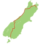
The New Zealand State Highway network is the major national highway network in New Zealand. Just under 100 roads in both the North and South Islands are State Highways...
. It extends from the northeastern corner of the South Island
South Island
The South Island is the larger of the two major islands of New Zealand, the other being the more populous North Island. It is bordered to the north by Cook Strait, to the west by the Tasman Sea, to the south and east by the Pacific Ocean...
across the top of the island, then down the length of the island, initially along the West Coast and then across the Southern Alps
Southern Alps
The Southern Alps is a mountain range extending along much of the length of New Zealand's South Island, reaching its greatest elevations near the island's western side...
through inland Otago and finally across the Southland Plains
Southland Plains
The Southland Plains is a general name given to several areas of low-lying land in the South Island of New Zealand, separated by the rise of the Hokonui Hills in the north. It forms a sizeable area of Southland Region and encompasses its two principal settlements the city of Invercargill and the...
to the island's south coast. Distances are measured from north to south.
The highway is the longest single highway in the country, though it is shorter than the combined totals of the two highways that comprise State Highway 1
State Highway 1 (New Zealand)
State Highway 1 is the longest and most significant road in the New Zealand roading network, running the length of both main islands. It appears on road maps as SH 1 and on road signs as a white number 1 on a red shield, but it has the official designations SH 1N in the North Island, SH 1S in the...
, SHs 1N and 1S.
For most of its length SH6 is a two-lane single carriageway, except for 5.4 km of dual carriageway
Dual carriageway
A dual carriageway is a class of highway with two carriageways for traffic travelling in opposite directions separated by a central reservation...
in Invercargill, and passing lanes
2+1 road
2+1 road is a specific category of three-lane road, consisting of two lanes in one direction and one lane in the other, alternating every few kilometres, and separated usually with a steel cable barrier. Traditional roads of at least width can be converted to 2+1 roads and reach near-motorway...
in Invercargill and Nelson, with at-grade intersections and property accesses, both in rural and urban areas. Roundabouts are common in major towns, with traffic signals only found in Invercargill, Richmond, and Nelson, with signals controlling the Kawarau Bridge in Queenstown and Hawks Crag near Westport.
Nelson/Marlborough
The highway leaves SH1 at BlenheimBlenheim, New Zealand
Blenheim is the most populous town in the region of Marlborough, in the north east of the South Island of New Zealand, and the seat of the regional council. It has a population of The area which surrounds the town is well known as a centre of New Zealand's wine industry...
, initially heading northeastward across the rugged hills at the base of the Marlborough Sounds
Marlborough Sounds
The Marlborough Sounds are an extensive network of sea-drowned valleys created by a combination of land subsidence and rising sea levels at the north of the South Island of New Zealand...
. it reaches the sounds briefly at Havelock
Havelock, New Zealand
Havelock is a coastal village in the Marlborough region of New Zealand. It sits at the head of Pelorus Sound, one of the Marlborough Sounds. The population was 486 in the 2006 Census, an increase of 12 from 2001....
, then heads inland up the valley of the Pelorus River
Pelorus River
The Pelorus River is a river at the northern end of South Island of New Zealand in the region of Marlborough. It flows from the Richmond Range into Pelorus Sound. This area is fantastic for camping and is renowned for its magnificent river swimming where the Pelorus River runs through a gorge....
. At Pelorus Bridge the highway again turns north, then tends southwest as it approaches the coast of Tasman Bay
Tasman Bay
Tasman Bay is a large V-shaped bay at the north end of New Zealand's South Island. Located in the centre of the island's northern coast, it stretches along of coastline and is across at its widest point. It is an arm of the Tasman Sea, lying on the western approach to Cook Strait.At the bay's...
. The highway travels through the city of Nelson
Nelson, New Zealand
Nelson is a city on the eastern shores of Tasman Bay, and is the economic and cultural centre of the Nelson-Tasman region. Established in 1841, it is the second oldest settled city in New Zealand and the oldest in the South Island....
and nearby town of Richmond
Richmond, New Zealand
Richmond, the seat of the Tasman District Council, lies 13 km south of Nelson in the South Island of New Zealand, close to the southern extremity of Tasman Bay...
, continuing southwest across the plains of the Wairoa
Wairoa River
Wairoa is the name of several rivers and streams in New Zealand. Wairoa is Māori for long water.* Wairoa River * Wairoa River * Wairoa River * Wairoa River * Wairoa River...
and Motueka River
Motueka River
The Motueka River is located in the north of the South Island of New Zealand and is a popular tourist destination for watersports and fishing. The Motueka flows from the mountains 40 km west of the city of Nelson in the southeast of the catchment and flows north to the Tasman...
s.
From these plains, the road ascends rapidly to the 613-metre Hope Saddle
Hope Saddle
Hope Saddle is a saddle located in the Hope Range of the northern South Island. It lies above the Clark Valley....
. From here, the highway heads generally westward, along the valley of the Buller River
Buller River
The Buller River is in the South Island of New Zealand. One of the country's longest rivers, it flows for 170 kilometres from Lake Rotoiti through the Buller Gorge and into the Tasman Sea near the town of Westport...
and its tributaries. Beyond Murchison
Murchison, New Zealand
Murchison is a town in the Tasman Region of the South Island of New Zealand. It is near the western end of the "Four Rivers Plain", at the confluence of the Buller River and the Matakitaki River...
, this valley narrows to become the scenic Buller Gorge
Buller Gorge
The Buller Gorge is a gorge located in the northwest of the South Island of New Zealand. The Buller River flows through the deep canyon between Murchison and Westport. Land Information New Zealand lists two sections for the gorge, Upper Buller Gorge and Lower Buller Gorge. State Highway 6 runs...
, and the highway twists its way high above the waters of the river.
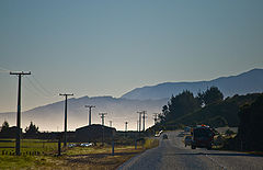
West Coast
The highway leaves the river as its valley broadens, turning south six kilometres from WestportWestport, New Zealand
-Economy:Economic activity is based around fishing, coal mining and dairy farming. Historically, gold mining was a major industry, and coal mining was much more extensive than today . However, the region still is home to New Zealand's largest opencast mining operation in Stockton...
, where the river reaches the sea. From here, the highway keeps close to the Tasman coast from Charleston
Charleston, New Zealand
Charleston is a village in the South Island of New Zealand located 30 km south of Westport. It was founded as a goldmining town after a major goldrush in 1867, and is now an adventure tourist village noted for its extensive limestone caves and caving experiences.- History :Charleston’s origins...
for over 100 kilometres, turning inland only briefly near Runanga
Runanga, New Zealand
Runanga is a small town on the West Coast of the South Island of New Zealand. It is located ten kilometres to the northwest of Greymouth, to the north of the Grey River. Barrytown is 21 kilometres further north...
. This 100-kilometre stretch includes two of the coast's larger towns, Greymouth
Greymouth
Greymouth is the largest town in the West Coast region in the South Island of New Zealand, and the seat of the Grey District Council. The population of the whole Grey District is , which accounts for % of the West Coast's inhabitants...
and Hokitika.
From Hokitika, the highway moves away from the coast, though still generally keeps within five kilometres of the sea. The highway continues south past Ross
Ross, New Zealand
Ross is a small town located on the West Coast of New Zealand's South Island.It lies 27 kilometres south-west of Hokitika and 46 kilometres north-east of Harihari...
and Harihari
Harihari
Hari Hari -Maori Meaning, from Te Aka Maori/English Dictionary is "To Take/Carry Joy" or, as local legend suggests, "Come together in Unison" from a Maori canoe paddling chant/song. In recent years, Hari Hari has been increasingly referred to as "Harihari" – Maori Meaning is "Ambulance"...
, moving through state forests as it crosses several fast-moving rivers. Seventy kilometres south of Harihari, the highway skirts Lake Mapourika
Lake Mapourika
Lake Mapourika is located on the West Coast of New Zealand's South Island. It lies north of Franz Josef Glacier, and drains into the Okarito Lagoon. It is the largest of the West Coast lakes, a glacier formation from the last ice age...
and reaches the tourist settlement of Franz Josef Glacier
Franz Josef Glacier
The Franz Josef is a long glacier located in Westland Tai Poutini National Park on the West Coast of New Zealand's South Island...
. The glacier itself, one of two within easy walking distance of the highway, lies nearby in the Southern Alps
Southern Alps
The Southern Alps is a mountain range extending along much of the length of New Zealand's South Island, reaching its greatest elevations near the island's western side...
, which here come very close to the Tasman coast. The second glacier, Fox Glacier
Fox Glacier
The Fox Glacier is a long glacier located in Westland Tai Poutini National Park on the West Coast of New Zealand's South Island...
is located some 20 kilometres further south. The highway again briefly touches the coast at Bruce Bay
Bruce Bay
Bruce Bay or Mahitahi is a bay in South Westland, New Zealand, New Zealand on the Tasman Sea. It is south of the mouth of the Mahitahi River, 80 km from Haast Junction and 224 km from Hokitika...
before heading inland past Lake Paringa
Lake Paringa
Lake Paringa is a small lake 30 kilometres north of Haast on the West Coast of New Zealand's South Island. It is set in rugged but picturesque terrain close to State Highway 6, six kilometres inland from the coast of the Tasman Sea...
, before reemerging on the Tasman coast at Knights Point. The 30 km stretch of highway from here south to Haast
Haast, New Zealand
Haast is an area in the Westland District territorial authority on the west coast of New Zealand's South Island. The Haast region covers over ....
is noted for its rugged scenery.
After crossing the Haast River
Haast River
The Haast River has its terminus on the West Coast of the South Island of New Zealand.The Haast River drains the western watershed of the Haast Pass. It is 100 kilometres in length, and enters the Tasman Sea near Haast township. The river's main tributary is the Landsborough River.The grassy flats...
, the highway turns eastward and inland up the river's valley, climbing past the Gates of Haast and crossing the 563-metre Haast Pass
Haast Pass
Haast Pass is a mountain pass in the Southern Alps of the South Island of New Zealand. It is named for Julius von Haast, a 19th century explorer who was also geologist for the Provincial government of Canterbury...
, the southernmost of the three main road passes across the Southern Alps.
Otago
From here, the highway again turns south, following the Makarora RiverMakarora River
-Geography:The headwaters are in Mount Aspiring National Park, on the eastern flanks of the Southern Alps near Haast Pass, which is the saddle between the Makarora and Haast River valleys. The Makarora flows south into the northern end of Lake Wanaka after passing the small community of Makarora...
valley to the northern tip of Lake Wanaka
Lake Wanaka
Lake Wanaka is located in the Otago region of New Zealand, at an altitude of 300 metres. Covering an area of , it is New Zealand's fourth largest lake, and estimated to be more than deep...
. The highway skirts the eastern coast of the lake before crossing The Neck, a saddle in the mountains that lie between Lakes Wanaka and Hawea
Lake Hawea
Lake Hawea is located in the Otago Region of New Zealand, at an altitude of 348 metres. It covers an area of some 141 km² and is, at its deepest, 392 metres deep...
. The highway continues along the western shore of Hawea, then south along the Cardrona River
Cardrona River
The Cardrona River is found in Otago in the South Island of New Zealand. It is one of the first tributaries of the Clutha River, which it meets only five kilometres from the latter's origin at the outflow of Lake Wanaka....
to Albert Town
Albert Town, New Zealand
Albert Town is located to the east of Wanaka in Otago, New Zealand. Until recently only a farming settlement, the population boom in this area has led to much new development. The confluence of the Clutha and Cardrona Rivers is located here. The town was named after Prince Albert of Saxe-Coburg and...
, close to the tourist centre of Wanaka
Wanaka
Wanaka is a town in the Otago region of the South Island of New Zealand. It is situated at the southern end of Lake Wanaka, adjacent to the outflow of the lake to the Clutha River. It is the gateway to Mount Aspiring National Park. Wanaka is primarily a resort town but has both summer and winter...
.
Lake Dunstan
Lake Dunstan is a man-made lake and reservoir in the South Island of New Zealand.The lake was formed on the Clutha River as a result of the construction of the Clyde Dam, filling in four controlled stages beginning in April 1992 and completed the next year...
. SH 6 continues south along the western shore of the Lake, paralleling SH 8 which lies on the eastern shore. Close to Cromwell
Cromwell, New Zealand
Cromwell is a town in Central Otago in the Otago region of New Zealand.It is situated between State Highway 6 and State Highway 8 leading to the Lindis Pass, 75 km northeast, and Alexandra, 33 km south. The road to Alexandra winds through the Cromwell Gorge...
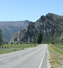
, a second spur, SH 8B, connects the two highways. From here, SH6 turns west, following the narrow and twisting Kawarau Gorge
Kawarau Gorge
The Kawarau Gorge is a major river gorge, located in Central Otago, in the South Island of New Zealand. The Kawarau River flows through the gorge, which is located between the towns of Queenstown and Cromwell, and part of the route of State Highway 6 also follows the gorge.The gorge begins some 30...
, emerging close to the wine-producing area of Gibbston.
At the western end of the Kawarau Gorge, midway between Cromwell and Queenstown, the highway passes the Nevis Bluff, a steep schist rock outcrop rising 100 m above the Kawarau River
Kawarau River
Kawarau River drains Lake Wakatipu, in northwestern Otago, New Zealand. The river flows generally eastwards for about 60 km and passes through the steep Kawarau Gorge until it joins Lake Dunstan near Cromwell. The Shotover River enters it from the north; the Nevis River enters it from the south...
. The highway has a history of being disrupted and closed at this point due to instability and rock falls from the bluff. The first road around the bluff was constructed in 1866, opening access to the Wakatipu goldfields. Significant slips occurred at the bluff on 1940-02-20, and blocking SH6 in June 1975. On 17 September 2000, a large-scale rock fall buried the highway at the bluff, and several motorists narrowly avoided being killed. The fall was caught on video and showed a volume of 10,000 m³ for the main fall; the resulting dust cloud was seen 5 km away. Transit New Zealand
Transit New Zealand
Transit New Zealand was, from 1989 to 2008, the New Zealand Crown entity responsible for operating and planning the New Zealand State Highway network...
conducted stabilisation drilling and blasting at the bluff twice in 2006 and again in 2007.
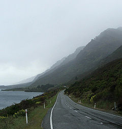
From the Nevis Bluff, the highway continues west, reaching Frankton
Frankton, Otago
Frankton is a settlement close to and effectively part of the town of Queenstown in the South Island of New Zealand.Frankton is located at the end of a large inlet in the northeastern shore of Lake Wakatipu known as the Frankton Arm on State Highway 6...
, close to the shore of Lake Wakitipu. The highway turns south to follow the southeastern shore of the lake, skirting the foot of The Remarkables and the Hector Mountains. This stretch of the highway is in part tortuously winding, and rises and falls over a stretch known as "The Devil's Staircase".
Southland
The highway leaves the lake's shore at KingstonKingston, New Zealand
Kingston is a small town at the southernmost end of Lake Wakatipu on the border of Otago and Southland, in New Zealand's South Island. It is 47 kilometres south of Queenstown by a road which winds between the lake to the west and The Remarkables mountains to the east...
, continuing south to Garston, where, the highway briefly follows the course of the infant Mataura River
Mataura River
The Mataura River is in the Southland Region of the South Island of New Zealand. It is 190 kilometres in length.The river's headwaters are located in mountains to the south of Lake Wakatipu. From there it flows southeast towards Gore, where it turns southward...
before heading across rolling hill country to the upper reaches of the Oreti River
Oreti River
The Oreti River is one of the main rivers of Southland, New Zealand, and is 170 kilometres in length.The Oreti has its headwaters close to the Mavora Lakes between Lake Te Anau and Lake Wakatipu, and flows south across the Southland Plains to its outflow into Foveaux Strait at the southeastern end...
near Lowther. The highway continues to follow the Oreti south across the Southland Plains
Southland Plains
The Southland Plains is a general name given to several areas of low-lying land in the South Island of New Zealand, separated by the rise of the Hokonui Hills in the north. It forms a sizeable area of Southland Region and encompasses its two principal settlements the city of Invercargill and the...
, past the towns of Lumsden
Lumsden, New Zealand
Lumsden is a town in Southland, New Zealand. Lying in a gap in the surrounding hills, it is the location of a major junction halfway along the north-south road from Queenstown to Invercargill, where it is crossed by the east-west road from Gore to Te Anau. The town had a population of 453 as of the...
and Winton
Winton, New Zealand
Winton is a town in Southland, New Zealand. It is located close to the east bank of the Oreti River, 30 kilometres north of Invercargill and 50 kilometres south of Lumsden. It is named after Thomas Winton, a local stockman who lived in the area in the 1850s...
before reaching its terminus at a junction with SH 1
State Highway 1 (New Zealand)
State Highway 1 is the longest and most significant road in the New Zealand roading network, running the length of both main islands. It appears on road maps as SH 1 and on road signs as a white number 1 on a red shield, but it has the official designations SH 1N in the North Island, SH 1S in the...
in central Invercargill
Invercargill
Invercargill is the southernmost and westernmost city in New Zealand, and one of the southernmost cities in the world. It is the commercial centre of the Southland region. It lies in the heart of the wide expanse of the Southland Plains on the Oreti or New River some 18 km north of Bluff,...
.
State Highway 6 spurs
SH6 has one spur, designated State Highway 6A (also part of the Southern Scenic Route
Southern Scenic Route
The Southern Scenic Route is a tourist highway in New Zealand linking Queenstown, Fiordland, Te Anau and the iconic Milford Road to Dunedin via, Riverton, Invercargill and The Catlins...
). This 6.9 km highway links Frankton
Frankton, Otago
Frankton is a settlement close to and effectively part of the town of Queenstown in the South Island of New Zealand.Frankton is located at the end of a large inlet in the northeastern shore of Lake Wakatipu known as the Frankton Arm on State Highway 6...
with the tourist centre of Queenstown
Queenstown, New Zealand
Queenstown is a resort town in Otago in the south-west of New Zealand's South Island. It is built around an inlet called Queenstown Bay on Lake Wakatipu, a long thin Z-shaped lake formed by glacial processes, and has spectacular views of nearby mountains....
.
Engineering features
- Hawk's Crag is a single-lane half tunnel blasted out of a solid rock bluff in the Buller Gorge. It was constructed before 1900.
- The highway featured a number of combined road-rail bridges, but several have now been replaced.
- The Haast RiverHaast RiverThe Haast River has its terminus on the West Coast of the South Island of New Zealand.The Haast River drains the western watershed of the Haast Pass. It is 100 kilometres in length, and enters the Tasman Sea near Haast township. The river's main tributary is the Landsborough River.The grassy flats...
bridge (km 750.0) is now the longest single-lane bridge in the country, with two passing bays.
Major junctions
| Territorial authority | Location | km | Destinations | Notes |
|---|---|---|---|---|
| Malborough District Malborough Malborough is a village located in the South Hams region of Devon. The village is located on the A381 between Kingsbridge and Salcombe, and is a popular village for tourists with many holiday homes located around the village.... |
Blenheim Blenheim, New Zealand Blenheim is the most populous town in the region of Marlborough, in the north east of the South Island of New Zealand, and the seat of the regional council. It has a population of The area which surrounds the town is well known as a centre of New Zealand's wine industry... |
0 |   SH 1/Classic New Zealand Wine Trail north SH 1/Classic New Zealand Wine Trail north (Grove Road) Picton Picton, New Zealand Picton is a town in the Marlborough region of New Zealand. It is close to the head of Queen Charlotte Sound near the north-east corner of the South Island. The population was 2928 in the 2006 Census, a decrease of 72 from 2001... , Wellington Wellington Wellington is the capital city and third most populous urban area of New Zealand, although it is likely to have surpassed Christchurch due to the exodus following the Canterbury Earthquake. It is at the southwestern tip of the North Island, between Cook Strait and the Rimutaka Range... Ferry |
SH 6 begins |
| SH 1/Classic New Zealand Wine Trail south (Sinclair Street) Kaikoura Kaikoura Kaikoura is a town on the east coast of the South Island of New Zealand. It is located on State Highway 1 180 km north of Christchurch.Kaikoura became the first local authority to reach the Green Globe tourism certification standard.... , Christchurch Christchurch Christchurch is the largest city in the South Island of New Zealand, and the country's second-largest urban area after Auckland. It lies one third of the way down the South Island's east coast, just north of Banks Peninsula which itself, since 2006, lies within the formal limits of... |
||||
| Renwick Renwick, New Zealand Renwick is a small town in Marlborough, New Zealand, close to the south bank of the Wairau River. It is located on State Highway 6, 12 km west of Blenheim. Havelock is 31 km north... |
10 |  SH 63 SH 63New Zealand State Highway 63 State Highway 63 is a New Zealand State Highway located in the northern parts of the South Island of New Zealand. It is 117 km long and runs between the settlements of Renwick and Kawatiri Junction via Saint Arnaud, providing a bypass of the city of Nelson.-Route:SH 63 begins just to the... St Arnaud Saint Arnaud, New Zealand Saint Arnaud is a small alpine village located in the north of New Zealand's South Island, west of the mountains of the Saint Arnaud Range and 90 kilometres southwest of Nelson near the historic Tophouse Settlement... , Westport Westport, New Zealand -Economy:Economic activity is based around fishing, coal mining and dairy farming. Historically, gold mining was a major industry, and coal mining was much more extensive than today . However, the region still is home to New Zealand's largest opencast mining operation in Stockton... |
Alternative route to Westport Westport, New Zealand -Economy:Economic activity is based around fishing, coal mining and dairy farming. Historically, gold mining was a major industry, and coal mining was much more extensive than today . However, the region still is home to New Zealand's largest opencast mining operation in Stockton... , bypassing Nelson Nelson, New Zealand Nelson is a city on the eastern shores of Tasman Bay, and is the economic and cultural centre of the Nelson-Tasman region. Established in 1841, it is the second oldest settled city in New Zealand and the oldest in the South Island.... |
|
 SH 62 SH 62 (Rapaura Road) Picton Picton, New Zealand Picton is a town in the Marlborough region of New Zealand. It is close to the head of Queen Charlotte Sound near the north-east corner of the South Island. The population was 2928 in the 2006 Census, a decrease of 72 from 2001... |
Alternative route to Picton Picton, New Zealand Picton is a town in the Marlborough region of New Zealand. It is close to the head of Queen Charlotte Sound near the north-east corner of the South Island. The population was 2928 in the 2006 Census, a decrease of 72 from 2001... , bypassing Blenheim Blenheim, New Zealand Blenheim is the most populous town in the region of Marlborough, in the north east of the South Island of New Zealand, and the seat of the regional council. It has a population of The area which surrounds the town is well known as a centre of New Zealand's wine industry... |
|||
| Wairau River Wairau River The Wairau River is one of the longest rivers in New Zealand's South Island. It flows for 170 kilometres from the Spenser Mountains , firstly in a northwards direction and then northeast down a long, straight valley in inland Marlborough.The river's lower reaches are noted for the surrounding... |
||||
| Nelson City Nelson, New Zealand Nelson is a city on the eastern shores of Tasman Bay, and is the economic and cultural centre of the Nelson-Tasman region. Established in 1841, it is the second oldest settled city in New Zealand and the oldest in the South Island.... |
District contains no major junctions | |||
| Tasman District | Richmond Richmond, New Zealand Richmond, the seat of the Tasman District Council, lies 13 km south of Nelson in the South Island of New Zealand, close to the southern extremity of Tasman Bay... |
 SH 60 SH 60 (Appleby Highway) Motueka Motueka The town of Motueka in the South Island of New Zealand lies close to the mouth of the Motueka River, on the western shore of Tasman Bay. It is, after Nelson and Richmond, the third largest centre in the Tasman Region, with a population of 7125... , Collingwood Collingwood, New Zealand Collingwood is a town in the north-west corner of the South Island of New Zealand. It is located in the hub of the Aorere Valley, in the western half of the Golden Bay area.-Geography:The town lies at the end of State Highway 60 in Golden Bay... |
||
| Kawatiri | 209 | SH 63 New Zealand State Highway 63 State Highway 63 is a New Zealand State Highway located in the northern parts of the South Island of New Zealand. It is 117 km long and runs between the settlements of Renwick and Kawatiri Junction via Saint Arnaud, providing a bypass of the city of Nelson.-Route:SH 63 begins just to the... St Arnaud Saint Arnaud, New Zealand Saint Arnaud is a small alpine village located in the north of New Zealand's South Island, west of the mountains of the Saint Arnaud Range and 90 kilometres southwest of Nelson near the historic Tophouse Settlement... , Picton Picton, New Zealand Picton is a town in the Marlborough region of New Zealand. It is close to the head of Queen Charlotte Sound near the north-east corner of the South Island. The population was 2928 in the 2006 Census, a decrease of 72 from 2001... |
Alternative route to Blenheim Blenheim, New Zealand Blenheim is the most populous town in the region of Marlborough, in the north east of the South Island of New Zealand, and the seat of the regional council. It has a population of The area which surrounds the town is well known as a centre of New Zealand's wine industry... , bypassing Nelson Nelson, New Zealand Nelson is a city on the eastern shores of Tasman Bay, and is the economic and cultural centre of the Nelson-Tasman region. Established in 1841, it is the second oldest settled city in New Zealand and the oldest in the South Island.... |
|
| Longford | 238 | Longford Bridge Buller River Buller River The Buller River is in the South Island of New Zealand. One of the country's longest rivers, it flows for 170 kilometres from Lake Rotoiti through the Buller Gorge and into the Tasman Sea near the town of Westport... |
||
| Ariki | 255 |  SH 65 SH 65 Springs Junction, Christchurch Christchurch Christchurch is the largest city in the South Island of New Zealand, and the country's second-largest urban area after Auckland. It lies one third of the way down the South Island's east coast, just north of Banks Peninsula which itself, since 2006, lies within the formal limits of... (via Lewis Pass Lewis Pass Lewis Pass is a mountain pass in the South Island of New Zealand.The northernmost of the three main passes across the Southern Alps, it is higher than the Haast Pass, but slightly lower than Arthur's Pass... ) |
||
| O'Sullivan's Bridge Buller River Buller River The Buller River is in the South Island of New Zealand. One of the country's longest rivers, it flows for 170 kilometres from Lake Rotoiti through the Buller Gorge and into the Tasman Sea near the town of Westport... |
||||
| Buller District Buller District 200px|rightBuller District, administered by the Buller District Council is an administrative region in the West Coast Region of New Zealand. It covers Westport, Karamea, Reefton and Inangahua Junction. Its land area is 7,953.12 km²... |
Lyell Lyell, New Zealand Lyell is the site of a historic gold mining town in the Buller Gorge in the South Island of New Zealand. It lies on State Highway 6The location is now a campsite maintained by the Department of Conservation. None of the original buildings remain but a track from the campsite leads to a cemetery and... |
282 | Iron Bridge Buller River Buller River The Buller River is in the South Island of New Zealand. One of the country's longest rivers, it flows for 170 kilometres from Lake Rotoiti through the Buller Gorge and into the Tasman Sea near the town of Westport... |
|
| Inangahua Junction Inangahua Junction Inangahua Junction is a small town in the northwest of New Zealand's South Island. It is located at the confluence of the Inangahua and Buller Rivers, 34 kilometres north of Reefton and 46 kilometres southeast of Westport. Murchison is 52 kilometres to the east. The town of Inangahua is just to the... |
297 |  SH 69 SH 69 Reefton Reefton, New Zealand Reefton is a small town on New Zealand's West Coast region, some 80 km northeast of Greymouth, in the valley of the Inangahua River. State Highway 7 passes through the southern part of the town, and State Highway 69 runs north to connect to State Highway 6... , Greymouth, Christchurch Christchurch Christchurch is the largest city in the South Island of New Zealand, and the country's second-largest urban area after Auckland. It lies one third of the way down the South Island's east coast, just north of Banks Peninsula which itself, since 2006, lies within the formal limits of... (via Lewis Pass Lewis Pass Lewis Pass is a mountain pass in the South Island of New Zealand.The northernmost of the three main passes across the Southern Alps, it is higher than the Haast Pass, but slightly lower than Arthur's Pass... ) |
Alternative route to Greymouth, bypassing Westport Westport, New Zealand -Economy:Economic activity is based around fishing, coal mining and dairy farming. Historically, gold mining was a major industry, and coal mining was much more extensive than today . However, the region still is home to New Zealand's largest opencast mining operation in Stockton... |
|
| Westport |  SH 67 SH 67New Zealand State Highway 67 State Highway 67 is a New Zealand State Highway located in the northern parts of the South Island of New Zealand. It is 51.2 km long and connects State Highway 6 with the settlement of Mokihinui. It used to be 96 kilometres long and ran the entire length of the road to Karamea... Westport Westport, New Zealand -Economy:Economic activity is based around fishing, coal mining and dairy farming. Historically, gold mining was a major industry, and coal mining was much more extensive than today . However, the region still is home to New Zealand's largest opencast mining operation in Stockton... , Karamea Karamea Karamea is a town on the West Coast of the South Island of New Zealand.It is the northernmost settlement of any real size on the West Coast, and is located 96 kilometres north-east by road from Westport. There is no other connecting road to the town - the road north ends at the Kohaihai River some... |
|||
| Grey District Grey District Grey District Council in the West Coast region of New Zealand is a municipality that covers Greymouth, Runanga, Blackball, Cobden and settlements along the Grey River. It has a land area of 3,516.48 km²... |
Greymouth Greymouth Greymouth is the largest town in the West Coast region in the South Island of New Zealand, and the seat of the Grey District Council. The population of the whole Grey District is , which accounts for % of the West Coast's inhabitants... |
430 |  SH 7 SH 7New Zealand State Highway 7 State Highway 7 is a major New Zealand State Highway. One of the eight national highways, it crosses the Southern Alps to link the West Coast Region with Canterbury and to form a link between the South Island's two longest highways, State Highway 1 and State Highway 6... (Omoto Road) Reefton Reefton, New Zealand Reefton is a small town on New Zealand's West Coast region, some 80 km northeast of Greymouth, in the valley of the Inangahua River. State Highway 7 passes through the southern part of the town, and State Highway 69 runs north to connect to State Highway 6... , Nelson Nelson, New Zealand Nelson is a city on the eastern shores of Tasman Bay, and is the economic and cultural centre of the Nelson-Tasman region. Established in 1841, it is the second oldest settled city in New Zealand and the oldest in the South Island.... , Christchurch Christchurch Christchurch is the largest city in the South Island of New Zealand, and the country's second-largest urban area after Auckland. It lies one third of the way down the South Island's east coast, just north of Banks Peninsula which itself, since 2006, lies within the formal limits of... (via Lewis Pass Lewis Pass Lewis Pass is a mountain pass in the South Island of New Zealand.The northernmost of the three main passes across the Southern Alps, it is higher than the Haast Pass, but slightly lower than Arthur's Pass... ) |
Alternative route to Nelson, bypassing Westport Westport, New Zealand -Economy:Economic activity is based around fishing, coal mining and dairy farming. Historically, gold mining was a major industry, and coal mining was much more extensive than today . However, the region still is home to New Zealand's largest opencast mining operation in Stockton... |
| Westland District Westland District Westland District is a territorial authority on the west coast of New Zealand's South Island. Its population is - Government :The Westland District is governed by an elected Council, headed by an elected Mayor. The Mayor is elected at large. The current Mayor is Maureen Pugh. Councillors are... |
Kumara Junction | 448 |  SH 73 SH 73New Zealand State Highway 73 State Highway 73 is a major east-west South Island State Highway in New Zealand connecting Christchurch on the east coast with Greymouth/Hokitika on the west coast via the Southern Alps... (Otira Highway) Arthur's Pass (mountain pass), Christchurch Christchurch Christchurch is the largest city in the South Island of New Zealand, and the country's second-largest urban area after Auckland. It lies one third of the way down the South Island's east coast, just north of Banks Peninsula which itself, since 2006, lies within the formal limits of... |
|
| No major intersections for 367 km | ||||
| 815 | Haast Pass Haast Pass Haast Pass is a mountain pass in the Southern Alps of the South Island of New Zealand. It is named for Julius von Haast, a 19th century explorer who was also geologist for the Provincial government of Canterbury... 564 m (1,850.4 ft) |
|||
| Queenstown Lakes District Queenstown, New Zealand Queenstown is a resort town in Otago in the south-west of New Zealand's South Island. It is built around an inlet called Queenstown Bay on Lake Wakatipu, a long thin Z-shaped lake formed by glacial processes, and has spectacular views of nearby mountains.... |
||||
| Albert Town Albert Town, New Zealand Albert Town is located to the east of Wanaka in Otago, New Zealand. Until recently only a farming settlement, the population boom in this area has led to much new development. The confluence of the Clutha and Cardrona Rivers is located here. The town was named after Prince Albert of Saxe-Coburg and... |
891 | Clutha River Clutha River The Clutha River / Mata-Au is the second longest river in New Zealand flowing south-southeast through Central and South Otago from Lake Wanaka in the Southern Alps to the Pacific Ocean, south west of Dunedin. It is the highest volume river in New Zealand, and the swiftest, with a catchment of ,... |
||
| Mt Iron | 893 |  SH 84 SH 84New Zealand State Highway 84 State Highway 84 is a South Island State Highway in New Zealand. It connects the popular holiday resort of Wanaka to State Highway 6, the main north-south highway servicing the western part of the South Island.-Route:... (Wanaka Luggate Highway) Wanaka Wanaka Wanaka is a town in the Otago region of the South Island of New Zealand. It is situated at the southern end of Lake Wanaka, adjacent to the outflow of the lake to the Clutha River. It is the gateway to Mount Aspiring National Park. Wanaka is primarily a resort town but has both summer and winter... |
||
| Central Otago District | Luggate | 901 |  SH 8A SH 8ANew Zealand State Highway 8 State Highway 8 is one of New Zealand's eight national highways. It forms an anticlockwise loop through the southern scenic regions of the Mackenzie Basin and Central Otago, starting and terminating in junctions with State Highway 1... (Shortcut Road) Aoraki/Mount Cook Aoraki/Mount Cook Aoraki / Mount Cook is the highest mountain in New Zealand, reaching .It lies in the Southern Alps, the mountain range which runs the length of the South Island. A popular tourist destination, it is also a favourite challenge for mountain climbers... , Christchurch Christchurch Christchurch is the largest city in the South Island of New Zealand, and the country's second-largest urban area after Auckland. It lies one third of the way down the South Island's east coast, just north of Banks Peninsula which itself, since 2006, lies within the formal limits of... |
via Lindis Pass Lindis Pass Lindis Pass is located in the South Island of New Zealand.It lies between the towns of Cromwell in Central Otago and Omarama in North Otago, on the main inland route to the Mackenzie Basin in Canterbury.... |
| Cromwell Cromwell, New Zealand Cromwell is a town in Central Otago in the Otago region of New Zealand.It is situated between State Highway 6 and State Highway 8 leading to the Lindis Pass, 75 km northeast, and Alexandra, 33 km south. The road to Alexandra winds through the Cromwell Gorge... |
942 |  SH 8B SH 8BNew Zealand State Highway 8 State Highway 8 is one of New Zealand's eight national highways. It forms an anticlockwise loop through the southern scenic regions of the Mackenzie Basin and Central Otago, starting and terminating in junctions with State Highway 1... Cromwell, Aoraki/Mount Cook Aoraki/Mount Cook Aoraki / Mount Cook is the highest mountain in New Zealand, reaching .It lies in the Southern Alps, the mountain range which runs the length of the South Island. A popular tourist destination, it is also a favourite challenge for mountain climbers... , Dunedin Dunedin Dunedin is the second-largest city in the South Island of New Zealand, and the principal city of the Otago Region. It is considered to be one of the four main urban centres of New Zealand for historic, cultural, and geographic reasons. Dunedin was the largest city by territorial land area until... |
||
| Queenstown Lakes District Queenstown, New Zealand Queenstown is a resort town in Otago in the south-west of New Zealand's South Island. It is built around an inlet called Queenstown Bay on Lake Wakatipu, a long thin Z-shaped lake formed by glacial processes, and has spectacular views of nearby mountains.... |
Frankton Frankton, Otago Frankton is a settlement close to and effectively part of the town of Queenstown in the South Island of New Zealand.Frankton is located at the end of a large inlet in the northeastern shore of Lake Wakatipu known as the Frankton Arm on State Highway 6... |
996 | SH 6A/ Southern Scenic Route Southern Scenic Route The Southern Scenic Route is a tourist highway in New Zealand linking Queenstown, Fiordland, Te Anau and the iconic Milford Road to Dunedin via, Riverton, Invercargill and The Catlins... (Frankton Road) Queenstown Queenstown, New Zealand Queenstown is a resort town in Otago in the south-west of New Zealand's South Island. It is built around an inlet called Queenstown Bay on Lake Wakatipu, a long thin Z-shaped lake formed by glacial processes, and has spectacular views of nearby mountains.... |
SH 6/Southern Scenic Route concurrency begins |
| Southland District Southland District Southland District is a territorial authority in the South Island of New Zealand. Southland District covers the majority of the land area of Southland Region, although the region also covers Gore District, Invercargill City and adjacent territorial waters... |
Athol Athol, New Zealand Athol is a small town in Southland, New Zealand. It is located 55 km south of Queenstown, half way between Lumsden and Kingston. The name of Athol, is rumored to be derived from either Harry Athol, the owner of the township's first public house, or after Athol, Perthshire, Scotland, the home... |
1061 | Mataura River Mataura River The Mataura River is in the Southland Region of the South Island of New Zealand. It is 190 kilometres in length.The river's headwaters are located in mountains to the south of Lake Wakatipu. From there it flows southeast towards Gore, where it turns southward... |
|
| Five Rivers | 1082 |  SH 97/ Southern Scenic Route SH 97/ Southern Scenic RouteSouthern Scenic Route The Southern Scenic Route is a tourist highway in New Zealand linking Queenstown, Fiordland, Te Anau and the iconic Milford Road to Dunedin via, Riverton, Invercargill and The Catlins... (Mossburn Five Rivers Road) Te Anau Te Anau Te Anau is a town in the South Island of New Zealand. It is on the eastern shore of Lake Te Anau in Fiordland. Lake Te Anau is the largest lake in the South Island and second only within New Zealand to Lake Taupo. The 2001 census recorded the town's population as 1,857... , Milford Sound/Piopiotahi Milford Sound Milford Sound is a fjord in the south west of New Zealand's South Island, within Fiordland National Park, Piopiotahi Marine Reserve, and the Te Wahipounamu World Heritage site... |
Alternative route to Te Anau, bypassing Lumsden Lumsden, New Zealand Lumsden is a town in Southland, New Zealand. Lying in a gap in the surrounding hills, it is the location of a major junction halfway along the north-south road from Queenstown to Invercargill, where it is crossed by the east-west road from Gore to Te Anau. The town had a population of 453 as of the... SH 6/Southern Scenic Route concurrency ends |
|
| Lumsden Lumsden, New Zealand Lumsden is a town in Southland, New Zealand. Lying in a gap in the surrounding hills, it is the location of a major junction halfway along the north-south road from Queenstown to Invercargill, where it is crossed by the east-west road from Gore to Te Anau. The town had a population of 453 as of the... |
1093 |  SH 94 SH 94New Zealand State Highway 94 State Highway 94 is a New Zealand State Highway connecting the large Southland town of Gore with one of New Zealand's most popular destinations Milford Sound. It also passes the significant townships of Lumsden and Te Anau as well going through the Homer Tunnel... west (Mossburn Lumsden Highway) Te Anau Te Anau Te Anau is a town in the South Island of New Zealand. It is on the eastern shore of Lake Te Anau in Fiordland. Lake Te Anau is the largest lake in the South Island and second only within New Zealand to Lake Taupo. The 2001 census recorded the town's population as 1,857... , Milford Sound/Piopiotahi Milford Sound Milford Sound is a fjord in the south west of New Zealand's South Island, within Fiordland National Park, Piopiotahi Marine Reserve, and the Te Wahipounamu World Heritage site... |
SH 6/SH 94 concurrency begins | |
| 1095 | SH 94 New Zealand State Highway 94 State Highway 94 is a New Zealand State Highway connecting the large Southland town of Gore with one of New Zealand's most popular destinations Milford Sound. It also passes the significant townships of Lumsden and Te Anau as well going through the Homer Tunnel... east (Flora Road) Gore Gore, New Zealand Gore is a town, surrounding borough, and district in the Southland region of the South Island of New Zealand.-Geography:The Gore District has a land area of 1,251.62 km² and a resident population of... |
SH 6/SH 94 concurrency ends | ||
| Winton Winton, New Zealand Winton is a town in Southland, New Zealand. It is located close to the east bank of the Oreti River, 30 kilometres north of Invercargill and 50 kilometres south of Lumsden. It is named after Thomas Winton, a local stockman who lived in the area in the 1850s... |
 SH 96 SH 96New Zealand State Highway 96 State Highway 96 is a New Zealand State Highway connecting the Southland communities of Mataura, Winton, and Ohai. Starting at State Highway 1 the highway is 92 kilometers in length and runs in a general east-west direction. In Winton State Highway 96 runs concurrently with State Highway 6 for 1.6... west (Winton Wreys Bush Highway) Nightcaps Nightcaps Nightcaps is a town in the Southland Region of New Zealand's South Island. According to the 2001 New Zealand Census of Population and Dwellings, its population is 339, consisting of 186 males and 153 females. This represents a decline of 13.6% or 54 people since the 1996 census. State Highway 96... , Ohai Ohai Ohаi is a town in the Southland Region of New Zealand's South Island. It is located 65 kilometres northwest of Invercargill and 25 kilometres west of Winton. The 2001 New Zealand Census of Population and Dwellings gave its population as 399, a decline of 22.2% or 114 people since the 1996... |
SH 6/SH 96 concurrency begins | ||
| SH 96 New Zealand State Highway 96 State Highway 96 is a New Zealand State Highway connecting the Southland communities of Mataura, Winton, and Ohai. Starting at State Highway 1 the highway is 92 kilometers in length and runs in a general east-west direction. In Winton State Highway 96 runs concurrently with State Highway 6 for 1.6... east (Winton Hedgehope Highway) Mataura |
SH 6/SH 96 concurrency ends | |||
| Invercargill City Invercargill Invercargill is the southernmost and westernmost city in New Zealand, and one of the southernmost cities in the world. It is the commercial centre of the Southland region. It lies in the heart of the wide expanse of the Southland Plains on the Oreti or New River some 18 km north of Bluff,... |
Lorneville |  SH 98 SH 98 (Lorne Dacre Road) Dacre, Gore Gore, New Zealand Gore is a town, surrounding borough, and district in the Southland region of the South Island of New Zealand.-Geography:The Gore District has a land area of 1,251.62 km² and a resident population of... |
Alternative route to Gore Gore, New Zealand Gore is a town, surrounding borough, and district in the Southland region of the South Island of New Zealand.-Geography:The Gore District has a land area of 1,251.62 km² and a resident population of... , bypassing Invercargill Invercargill Invercargill is the southernmost and westernmost city in New Zealand, and one of the southernmost cities in the world. It is the commercial centre of the Southland region. It lies in the heart of the wide expanse of the Southland Plains on the Oreti or New River some 18 km north of Bluff,... |
|
 SH 99/ Southern Scenic Route SH 99/ Southern Scenic RouteSouthern Scenic Route The Southern Scenic Route is a tourist highway in New Zealand linking Queenstown, Fiordland, Te Anau and the iconic Milford Road to Dunedin via, Riverton, Invercargill and The Catlins... (Wallacetown Lorneville Highway) Riverton/Aparima Riverton, New Zealand Riverton or Aparima is a small town at the south of the South Island of New Zealand. It is in the Southland region and lies at the western end of Oreti Beach, 30 kilometres west of Invercargill on the Southern Scenic Route. It is approx. 45 km from Stewart Island and provides a safe harbour... , Tuatapere Tuatapere Tuatapere is a small rural town in Southland, New Zealand . It is located eight kilometres from the southern coast. The Waiau River flows through the town before reaching Te Waewae Bay, where it has its outflow into Foveaux Strait... |
SH 6/Southern Scenic Route concurrency begins | |||
| Invercargill Invercargill Invercargill is the southernmost and westernmost city in New Zealand, and one of the southernmost cities in the world. It is the commercial centre of the Southland region. It lies in the heart of the wide expanse of the Southland Plains on the Oreti or New River some 18 km north of Bluff,... |
SH 1 north/ Southern Scenic Route Southern Scenic Route The Southern Scenic Route is a tourist highway in New Zealand linking Queenstown, Fiordland, Te Anau and the iconic Milford Road to Dunedin via, Riverton, Invercargill and The Catlins... east (Tay Street) Gore Gore, New Zealand Gore is a town, surrounding borough, and district in the Southland region of the South Island of New Zealand.-Geography:The Gore District has a land area of 1,251.62 km² and a resident population of... , Dunedin Dunedin Dunedin is the second-largest city in the South Island of New Zealand, and the principal city of the Otago Region. It is considered to be one of the four main urban centres of New Zealand for historic, cultural, and geographic reasons. Dunedin was the largest city by territorial land area until... |
SH 6 ends | ||
| SH 1 south (Clyde Street) Bluff Bluff, New Zealand Bluff is a town and seaport in the Southland region, on the southern coast of the South Island of New Zealand. It is the southern-most town in New Zealand and, despite Slope Point being further to the south, is colloquially used to refer to the southern extremity of the country... |
||||
See also
- List of New Zealand State Highways
- List of roads and highways, for notable or famous roads worldwide