
Greymouth
Encyclopedia
Greymouth is the largest town in the West Coast
region in the South Island
of New Zealand
, and the seat of the Grey District Council. The population of the whole Grey District is , which accounts for % of the West Coast's inhabitants. The Greymouth urban area had an estimated population of The District Council expects growth of 1.5% per year between 2006 and 2016.
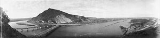
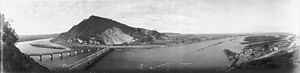
. In clear weather, Aoraki/Mount Cook
can be clearly seen to the south from near the town. The mouth of the river divides the town into three areas: Blaketown, close to the river's mouth on the south bank; Karoro, to the southeast, separated from Blaketown by a series of small estuarine lakes; and Cobden, formerly a separate town, on the river's north bank.
Greymouth is on State Highway 6
, which connects it with Hokitika in the south and Westport
in the north. It also stands at the terminus of State Highway 7
, which runs through Dobson
and Reefton
, eventually reaching North Canterbury
and its junction with State Highway 1 at Waipara (55 km north of Christchurch) via Lewis Pass
.Highway 73 is accessed just 20 kilometers south of Greymouth, which is the most direct route to or from Christchurch.
The town is also the western terminus of the Midland line
from Christchurch. Large coal trains often operate from Greymouth on this line to Christchurch. The famous TranzAlpine
train also terminates at Greymouth.
in 1846. Brunner discovered coal in the Grey valley, and several places in the region (notably the town of Brunner
and Lake Brunner
) bear his name. Brunner himself named the Grey River after prominent 19th century New Zealand politician Sir George Grey
. Together with gold, coal mining was a major impetus in the town's early European history.
From 1853 until the abolition of provinces in 1876, Greymouth was first part of Canterbury Province
(the West Coast part of the Province was known as West Canterbury) and then part of an independent Westland Province
. However Cobden, on the north (or right) bank of the Grey River was a part of Nelson Province
from 1853 to 1876. At one point in this period Greymouth tried to join Nelson Province
but this movement was ultimately unsuccessful.
 Greymouth has a history of coal
and gold
mining
. When the mining industry started to decline, forestry became a new staple industry. Fishing has long been important to the town, despite the fact that the entrance to the Grey River has two notoriously dangerous sandbars; an inner and outer bar.
Greymouth also has an historic World War II gun emplacement at Cobden. The Grey District Council destroyed part of this site, without consultation, in 2007 to make way for a sewer line.
On 10 March 2005, a major tornado
, which started as a waterspout
, made landfall in Blaketown, a suburb of Greymouth. It quickly moved through the town passing just south of the main town centre. The tornado was one of the largest reported in recent history in the West Coast region and caused millions of dollars in damage and injured several people.
On 19 November 2010, there was an explosion at the Pike River Mine
, trapping 29 miners. Attempts to rescue the trapped miners were repeatedly delayed due to high levels of methane gas until a second explosion on the 24th November was believed to dash all hope of survival for the miners.
, mining
, forestry
, and ecotourism
, the latter two of these industries holding an uneasy relationship with each other. The Pancake Rocks at Punakaiki
, 45 km to the north are a popular local tourist attraction, while many also pass through on the route to or from the glaciers to the south.
Greymouth is also known for its Pounamu ("Greenstone", a form of Jade
) carving industry which goes back to Māori origins. The town also has a local brewery, Monteith's
, which produces beer since 1868, now sold countrywide.
The planned opening of the Pike River mine
in early 2008 spurred new investments into upgrading port facilities at the town. Without the development, a closure of the port had been mooted, and hopes are now that the coal barges travelling to and from reshipment facilities in Taranaki can also carry containerised cargo to the town. The opening of the new mine, as well as the planned Spring Creek mine, was called the biggest investment happening in the area for a hundred years.
, Cobden
and Karoro
.
Greymouth High School
is a secondary (years 9-13) school with a roll of 655. Greymouth Main School is a full primary (years 1-8) school with a roll of 407.
John Paul II High School
is a secondary (years 9-13) school with a roll of 138. The school was formed in 1980 from the merger of Marist Brothers Boys’ School and St Mary’s High School. St Patrick's School is a full primary (years 1-8) school with a roll of 135. Both are state integrated Catholic schools. The schools are adjacent to each other and have a shared Board of Trustees.
West Coast, New Zealand
The West Coast is one of the administrative regions of New Zealand, located on the west coast of the South Island, and is one of the more remote and most sparsely populated areas of the country. It is made up of three districts: Buller, Grey and Westland...
region in the South Island
South Island
The South Island is the larger of the two major islands of New Zealand, the other being the more populous North Island. It is bordered to the north by Cook Strait, to the west by the Tasman Sea, to the south and east by the Pacific Ocean...
of New Zealand
New Zealand
New Zealand is an island country in the south-western Pacific Ocean comprising two main landmasses and numerous smaller islands. The country is situated some east of Australia across the Tasman Sea, and roughly south of the Pacific island nations of New Caledonia, Fiji, and Tonga...
, and the seat of the Grey District Council. The population of the whole Grey District is , which accounts for % of the West Coast's inhabitants. The Greymouth urban area had an estimated population of The District Council expects growth of 1.5% per year between 2006 and 2016.
Location
The town is located at the mouth of the Grey River, on a narrow coastal plain close to the foot of the Southern AlpsSouthern Alps
The Southern Alps is a mountain range extending along much of the length of New Zealand's South Island, reaching its greatest elevations near the island's western side...
. In clear weather, Aoraki/Mount Cook
Aoraki/Mount Cook
Aoraki / Mount Cook is the highest mountain in New Zealand, reaching .It lies in the Southern Alps, the mountain range which runs the length of the South Island. A popular tourist destination, it is also a favourite challenge for mountain climbers...
can be clearly seen to the south from near the town. The mouth of the river divides the town into three areas: Blaketown, close to the river's mouth on the south bank; Karoro, to the southeast, separated from Blaketown by a series of small estuarine lakes; and Cobden, formerly a separate town, on the river's north bank.
Greymouth is on State Highway 6
New Zealand State Highway 6
State Highway 6 is a major New Zealand State Highway. It extends from the northeastern corner of the South Island across the top of the island, then down the length of the island, initially along the West Coast and then across the Southern Alps through inland Otago and finally across the Southland...
, which connects it with Hokitika in the south and Westport
Westport, New Zealand
-Economy:Economic activity is based around fishing, coal mining and dairy farming. Historically, gold mining was a major industry, and coal mining was much more extensive than today . However, the region still is home to New Zealand's largest opencast mining operation in Stockton...
in the north. It also stands at the terminus of State Highway 7
New Zealand State Highway 7
State Highway 7 is a major New Zealand State Highway. One of the eight national highways, it crosses the Southern Alps to link the West Coast Region with Canterbury and to form a link between the South Island's two longest highways, State Highway 1 and State Highway 6...
, which runs through Dobson
Dobson, New Zealand
Dobson is a small town on the banks of the Grey River in the South Island of New Zealand. It is 10 kilometres east from the river's mouth at Greymouth. The settlement of Taylorville is across the river from Dobson, but no bridge directly connects the two...
and Reefton
Reefton, New Zealand
Reefton is a small town on New Zealand's West Coast region, some 80 km northeast of Greymouth, in the valley of the Inangahua River. State Highway 7 passes through the southern part of the town, and State Highway 69 runs north to connect to State Highway 6...
, eventually reaching North Canterbury
Canterbury, New Zealand
The New Zealand region of Canterbury is mainly composed of the Canterbury Plains and the surrounding mountains. Its main city, Christchurch, hosts the main office of the Christchurch City Council, the Canterbury Regional Council - called Environment Canterbury - and the University of Canterbury.-...
and its junction with State Highway 1 at Waipara (55 km north of Christchurch) via Lewis Pass
Lewis Pass
Lewis Pass is a mountain pass in the South Island of New Zealand.The northernmost of the three main passes across the Southern Alps, it is higher than the Haast Pass, but slightly lower than Arthur's Pass...
.Highway 73 is accessed just 20 kilometers south of Greymouth, which is the most direct route to or from Christchurch.
The town is also the western terminus of the Midland line
Midland Line, New Zealand
The Midland line is a 212 km section of railway between Rolleston and Greymouth in the South Island of New Zealand. The line features five major bridges, five viaducts and 17 tunnels, the longest of which is the Otira tunnel.-Freight services:...
from Christchurch. Large coal trains often operate from Greymouth on this line to Christchurch. The famous TranzAlpine
TranzAlpine
The TranzAlpine Express is a passenger train operated by Tranz Scenic in the South Island of New Zealand. This trip is often regarded to be one of the world's great train journeys for the scenery through which it passes . The journey is one-way, taking about four and a half hours...
train also terminates at Greymouth.
History
Māori had lived in Greymouth for considerable time before European settlement, and called the area Mawhera (for 'wide spread river mouth', still an alternative name for the Grey River). The first European to visit the site of what is now Greymouth was Thomas BrunnerThomas Brunner
Thomas Brunner was an English-born surveyor and explorer remembered for his exploration of the western coastal areas of New Zealand's South Island....
in 1846. Brunner discovered coal in the Grey valley, and several places in the region (notably the town of Brunner
Brunner, New Zealand
Brunner is a town in the northwest of New Zealand's South Island. Together with Taylorville and Dobson to the south-west, it had a population of 672 at the 2006 census. It is 12 kilometres to the east of Greymouth, on the south bank of the Grey River. It is on the Midland Line railway near its...
and Lake Brunner
Lake Brunner
Lake Brunner is the largest lake in the northwestern South Island of New Zealand, covering an area of 40 km². The lake's outflow is the Arnold River, a tributary of the Grey River. The lake lies 31 kilometres to the southeast of Greymouth...
) bear his name. Brunner himself named the Grey River after prominent 19th century New Zealand politician Sir George Grey
George Grey
George Grey may refer to:*Sir George Grey, 2nd Baronet , British politician*George Grey, 2nd Earl of Kent *Sir George Grey , Governor of Cape Colony, South Australia and New Zealand...
. Together with gold, coal mining was a major impetus in the town's early European history.
From 1853 until the abolition of provinces in 1876, Greymouth was first part of Canterbury Province
Canterbury Province
The Canterbury Province was a province of New Zealand from 1853 until the abolition of provincial government in 1876. On the east coast the province was bounded by the Hurunui River in the north and the Waitaki River in the south...
(the West Coast part of the Province was known as West Canterbury) and then part of an independent Westland Province
Westland Province
The Westland Province was a province of New Zealand from 1873 until the abolition of provincial government in 1876. The capital was Hokitika.-Area:...
. However Cobden, on the north (or right) bank of the Grey River was a part of Nelson Province
Nelson Province
The Nelson Province was a province of New Zealand from 1853 until the abolition of provincial government in 1876.-History:The Marlborough Province split away from the Nelson Province on 1 November 1859 because the majority of the income of the Provincial Council came from land sales in the...
from 1853 to 1876. At one point in this period Greymouth tried to join Nelson Province
Nelson Province
The Nelson Province was a province of New Zealand from 1853 until the abolition of provincial government in 1876.-History:The Marlborough Province split away from the Nelson Province on 1 November 1859 because the majority of the income of the Provincial Council came from land sales in the...
but this movement was ultimately unsuccessful.
Coal
Coal is a combustible black or brownish-black sedimentary rock usually occurring in rock strata in layers or veins called coal beds or coal seams. The harder forms, such as anthracite coal, can be regarded as metamorphic rock because of later exposure to elevated temperature and pressure...
and gold
Gold
Gold is a chemical element with the symbol Au and an atomic number of 79. Gold is a dense, soft, shiny, malleable and ductile metal. Pure gold has a bright yellow color and luster traditionally considered attractive, which it maintains without oxidizing in air or water. Chemically, gold is a...
mining
Mining
Mining is the extraction of valuable minerals or other geological materials from the earth, from an ore body, vein or seam. The term also includes the removal of soil. Materials recovered by mining include base metals, precious metals, iron, uranium, coal, diamonds, limestone, oil shale, rock...
. When the mining industry started to decline, forestry became a new staple industry. Fishing has long been important to the town, despite the fact that the entrance to the Grey River has two notoriously dangerous sandbars; an inner and outer bar.
Greymouth also has an historic World War II gun emplacement at Cobden. The Grey District Council destroyed part of this site, without consultation, in 2007 to make way for a sewer line.
On 10 March 2005, a major tornado
Tornado
A tornado is a violent, dangerous, rotating column of air that is in contact with both the surface of the earth and a cumulonimbus cloud or, in rare cases, the base of a cumulus cloud. They are often referred to as a twister or a cyclone, although the word cyclone is used in meteorology in a wider...
, which started as a waterspout
Waterspout
A waterspout is an intense columnar vortex that occurs over a body of water and is connected to a cumuliform cloud. In the common form, it is a non-supercell tornado over water. While it is often weaker than most of its land counterparts, stronger versions spawned by mesocyclones do occur...
, made landfall in Blaketown, a suburb of Greymouth. It quickly moved through the town passing just south of the main town centre. The tornado was one of the largest reported in recent history in the West Coast region and caused millions of dollars in damage and injured several people.
On 19 November 2010, there was an explosion at the Pike River Mine
Pike River Mine disaster
The Pike River Mine disaster was a coal mining accident that began on 19 November 2010 in the Pike River Mine, northeast of Greymouth, in the West Coast Region of New Zealand's South Island. A first explosion occurred in the mine at approximately 3:44 pm . At the time of the explosion 31...
, trapping 29 miners. Attempts to rescue the trapped miners were repeatedly delayed due to high levels of methane gas until a second explosion on the 24th November was believed to dash all hope of survival for the miners.
Economy
The town's major industries include fishingFishing
Fishing is the activity of trying to catch wild fish. Fish are normally caught in the wild. Techniques for catching fish include hand gathering, spearing, netting, angling and trapping....
, mining
Mining
Mining is the extraction of valuable minerals or other geological materials from the earth, from an ore body, vein or seam. The term also includes the removal of soil. Materials recovered by mining include base metals, precious metals, iron, uranium, coal, diamonds, limestone, oil shale, rock...
, forestry
Forestry
Forestry is the interdisciplinary profession embracing the science, art, and craft of creating, managing, using, and conserving forests and associated resources in a sustainable manner to meet desired goals, needs, and values for human benefit. Forestry is practiced in plantations and natural stands...
, and ecotourism
Ecotourism
Ecotourism is a form of tourism visiting fragile, pristine, and usually protected areas, intended as a low impact and often small scale alternative to standard commercial tourism...
, the latter two of these industries holding an uneasy relationship with each other. The Pancake Rocks at Punakaiki
Punakaiki
Punakaiki is a small community on the West Coast of the South Island of New Zealand, between Westport and Greymouth. The community lies on the edge of the Paparoa National Park....
, 45 km to the north are a popular local tourist attraction, while many also pass through on the route to or from the glaciers to the south.
Greymouth is also known for its Pounamu ("Greenstone", a form of Jade
Jade
Jade is an ornamental stone.The term jade is applied to two different metamorphic rocks that are made up of different silicate minerals:...
) carving industry which goes back to Māori origins. The town also has a local brewery, Monteith's
Monteith's
Monteith's Brewery Company was originally a family-owned brewing company until it was bought by DB Breweries. It continued to brew its beers on the West Coast of New Zealand until DB decided that the cost of keeping production there was no longer viable...
, which produces beer since 1868, now sold countrywide.
The planned opening of the Pike River mine
Pike River mine
The Pike River Mine is a coal mine operated by Pike River Coal north-northeast of Greymouth in the West Coast Region of New Zealand's South Island....
in early 2008 spurred new investments into upgrading port facilities at the town. Without the development, a closure of the port had been mooted, and hopes are now that the coal barges travelling to and from reshipment facilities in Taranaki can also carry containerised cargo to the town. The opening of the new mine, as well as the planned Spring Creek mine, was called the biggest investment happening in the area for a hundred years.
Education
There are four schools in the central Greymouth area, and other schools in the suburbs or adjoining areas of BlaketownBlaketown
Blaketown is a suburb to the west of Greymouth on the West Coast of New Zealand. The Grey River separates Blaketown from Cobden, and the Blaketown Lagoon separates it from the centre of Greymouth....
, Cobden
Cobden, New Zealand
Cobden is a suburb to the north of Greymouth on the West Coast of New Zealand. The Grey River separates Cobden from the rest of Greymouth. To the north is the Rapahoe Range, also called the Twelve Apostles Range...
and Karoro
Karoro, New Zealand
Karoro is a suburb to the south-west of Greymouth on the West Coast of New Zealand.The population was 879 in the 2006 Census, a decrease of 15 from 2001..-Education:...
.
Greymouth High School
Greymouth High School
Greymouth High School is the largest school on the West Coast of New Zealand with a roll of 649 sutdents. The school has a national distance learning division, Karoro Learning. The Mawhera Services Academy , a military orientated course, is a division of Greymouth High School.-External links:****...
is a secondary (years 9-13) school with a roll of 655. Greymouth Main School is a full primary (years 1-8) school with a roll of 407.
John Paul II High School
John Paul II High School (Greymouth)
John Paul II High School, Greymouth is an integrated Catholic, co-educational Year 9 to Year 13 secondary school located in Greymouth, New Zealand...
is a secondary (years 9-13) school with a roll of 138. The school was formed in 1980 from the merger of Marist Brothers Boys’ School and St Mary’s High School. St Patrick's School is a full primary (years 1-8) school with a roll of 135. Both are state integrated Catholic schools. The schools are adjacent to each other and have a shared Board of Trustees.
External links
- The district council's website
- Greymouth Street Map
- Photo of the road and rail bridges c1930
- Photo of SS Opouri off Greymouth bar c1948