
New Zealand State Highway 94
Encyclopedia
State Highway 94 is a New Zealand
State Highway
connecting the large Southland
town of Gore
with one of New Zealand's most popular destinations Milford Sound
. It also passes the significant townships of Lumsden
and Te Anau
as well going through the Homer Tunnel
(in this area it is also called the 'Milford Road', with the section from Te Anau up to the Sound being 119 km). The road also goes through Fiordland
and crosses the Main Divide of the Southern Alps
.
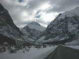
It is regarded as one of the most scenic roads in New Zealand, and with a peak elevation of 940m, also one of the country's highest. However, the "Milford Road" part is also one of the more dangerous public roads in New Zealand, with injury crash rates around 65% higher than the rest of New Zealand's network, and a fatality crash rate of almost twice average (per vehicle kilometre travelled), making it the third most dangerous section of New Zealand's State Highway network (as of 2008).
. Holmes initially preferred a route starting at Lake Wakatipu
and running northwest, but the decision was instead made to start from Te Anau.
However, the project then languished in planning for 40 years, possibly because in 1889 road building had been removed from the brief of the Public Works Department, and only reinstated with much more limited authority in 1909.
It took until 1935, to construct a rough road to the entrance of what would become Homer Tunnel
.
, SH 94 begins as Hokonui Drive and passes through the northern parts of Gore. Outside of Gore, the highway changes name to Waimea Highway and passes to the north of the Hokonui Hills
, a place historically known for illicit moonshine distilling. On the other side of the hills lies Mandeville
. The road then veers right and bisects the Waimea Plains
to pass through the settlements of Riversdale
(where the road names changes to Newcastle Street and then Lumsden Riversdale Highway once leaving the town) and Balfour
. The road proceeds in a northwesterly direction to arrive in Lumsden
(where it changes name to Flora Road).
From Lumsden, as Flora Road and Five Rivers Lumsden Highway, SH 94 merges with SH 6
and runs concurrently with SH 6 towards Queenstown
for 2.5 kilometres between the Oreti River
and the hills to the east before turning left to cross the river and back onto the plains as Mossburn Lumsden Highway. The road runs for a further 20 km towards Mossburn
, the self-proclaimed deer capital of New Zealand (name change to Devon Street). Tourist traffic from Queenstown turn onto SH 94 here from SH 97. Beyond Mossburn, the road changes name to Te Anau Mossburn Highway, and runs underneath a terrace carved by the Oreti River to the north before passing through more arable farmland and the turnoff to go to Mavora Lakes
, one of the locations used in the Lord of the Rings film trilogy. After the turnoff, the road heads into the hills and passes through undulating tussocklands and valleys before emerging back onto the plains at The Key. From The Key, the road proceeds on a more-or-less north-westerly direction across the plains before arriving at the lakeside resort of Te Anau
.
for about 29 km until it reaches Te Anau Downs. From Te Anau Downs, the road veers right and enters the Eglinton Valley
. The road then runs parallel to the right side of the Eglinton River
for 33 km while it passes through Knobs Flat. At Cascade Creek, the road emerges onto the shorelines of Lake Gunn
and Lake Fergus
. The road then passes through a saddle and emerges at the upper section of the Hollyford Valley
.
After Hollyford, the road veers to the west and rises steadily along the valley to its highest point at the Homer Tunnel
. At 1270 metres long it is the second-longest road tunnel in New Zealand (after the Lyttelton road tunnel
). The road then emerges at the head of the Cleddau Valley
and the road spends its last 16 kilometres descending along the valley to Milford Sound
.
, the Avenue of Disappearing Mountain, Lake Gunn
, the Key Summit, Mount Christina, Mount Talbot
, the Homer Tunnel
, The Chasm, Mount Tutoko
and Mitre Peak. Before the sealing of the road in the 1980s it was treated as a day's adventure from the township of Te Anau and Milford Sound
the climax of the journey. Modern marketing and faster buses have made Milford Sound a destination from Queenstown
involving 8 hours of bus transit, a round trip with few stops.
This route is part of the Te Wai Pounamu
Wilderness Area.
The Eglinton Mountains above Lake Gunn
were used as a location in the Peter Jackson
movie The Fellowship of the Ring
where the actors walk along a mountain path with the Key Summit evident in the distance. The mountains here were also used in the Fellowship of the Ring introduction to represent the Misty Mountains
. Emily Peak on the Routeburn Track
can also be seen in this movie, as well as the Mavora Lakes near Mossburn. Ironically, Peter Jackson picked an area that once contained New Zealand
's only place names from J. R. R. Tolkien
that were removed from the official maps in the 1980s, as they were deemed inappropriate for this region.
 There are many places of Local History not signposted by Transit New Zealand
, such as the Cleddau Horse Bridge, the Hollyford Hydro Powerstation remains, the Old Homer Tunnel
construction village site, however Transit New Zealand
has kept the historic White Mile Posts that are a feature of the early days of the Milford Road Construction. The Department of Conservation has kept up the Latitude 45 South Marker but has abandoned the Avenue of the Disappearing Mountain to history as the avenue of trees beside the Road has become over grown.
Outside of the Milford Road, Mandeville is the site of the Croydon Aircraft Company
Link, and the local aerodrome
is home to several rare vintage aircraft. Mossburn is the closest settlement to the Mount White Wind Farm which at full capacity can power almost all the entire Southland region. The Oreti
, Mataura
and Waiau
Rivers that dominate the flatter regions of SH 94 between Gore and Te Anau are popular fishing spots for brown trout
. Care should be taken while fishing to prevent the spread of Didymosphenia geminata
.
arrive mainly via coach
over the length of SH 94 from Mossburn, a predominantly high mountain road which is prone to avalanche
s in winter. The road was only opened in 1953, after the Homer Tunnel
was finished, after almost 20 years of intermittent work. The road is one of the more dangerous public roads in New Zealand, with injury crash rates around 65% higher than the rest of New Zealand's network, and a fatality crash rate of almost twice average (per vehicle kilometre travelled), making it the third most dangerous section of New Zealand's State Highway network (as of 2008). Stopping is prohibited on long stretches due to rock or snow avalanche dangers, and the road is often closed in winter, with the carrying of snow chains mandatory during snow conditions. Helicopters are used during winter to drop explosives onto snow buildup zones above the road in order to cause controlled avalanches. However this does not eliminate the danger that road traffic may be hit by an uncontrolled event, especially in the area of the Homer Tunnel portals.
There are no petrol stations on the length of the road from Te Anau to Milford Sound, meaning that vehicles need to take enough fuel for a return trip. All of this does not discourage up to 50 coaches and hundreds of private cars daily from making the 546 km trip from the nearest city Invercargill
, and the 572 km trip from popular tourist destination Queenstown
. Almost 60% of tourists travel via coach, which is regarded as being safer than attempting the road on your own.

 Avalanches are a winter hazard in the high mountains above the Milford Road and Snow and Ice effect the Road Surface in Winter Months, Transit Signs inform motorists of conditions and a Transit New Zealand
check point has been built to make sure road users carry chains for safe passage to Milford Sound
. Metal Gates are positioned across the Milford Road In the Hollyford and Cleddau Valleys when the road is closed at times of peak avalanche probability. Due to the nature of the Fiordland
Environment, the road can be closed at any time of year from landslips treefalls and washouts. Snow can fall on higher parts of the road any time of the year.
However the entire length of SH 94 is susceptible to snowfall during the winter months and care should be taken at any time of the year, especially on the hillier regions between Mossburn and Milford Sound. Flooding can also occur at anytime along the road especially around rivers.
and has been the subject of several books: Harold Anderson’s 1975 Men of the Milford Road, a detailed account of the project from his perspective as a Public Works Department Paymaster; Wilson Campbell’s 2000 Novel When stars were brightly shining about a fictional murder in one of the works camps; John Hall-Jones’s, Milford Sound An Illustrated History of the Sound, the Track and the Road, which covers in detail the history of the road with ample historic photographs; and Amy McDonalds 2005 Below the Mountains, a young girl's diary of living on the Milford Road 1935 to 1936.
And there are mountain climbing books that cover this area in detail, such as Jack Ede’s 1988 “Mountain Men of Milford” and Anita Crozier’s 1950 Beyond the Southern Lakes.
News
New Zealand
New Zealand is an island country in the south-western Pacific Ocean comprising two main landmasses and numerous smaller islands. The country is situated some east of Australia across the Tasman Sea, and roughly south of the Pacific island nations of New Caledonia, Fiji, and Tonga...
State Highway
New Zealand State Highway network
The New Zealand State Highway network is the major national highway network in New Zealand. Just under 100 roads in both the North and South Islands are State Highways...
connecting the large Southland
Southland Region
Southland is New Zealand's southernmost region and is also a district within that region. It consists mainly of the southwestern portion of the South Island and Stewart Island / Rakiura...
town of Gore
Gore, New Zealand
Gore is a town, surrounding borough, and district in the Southland region of the South Island of New Zealand.-Geography:The Gore District has a land area of 1,251.62 km² and a resident population of...
with one of New Zealand's most popular destinations Milford Sound
Milford Sound
Milford Sound is a fjord in the south west of New Zealand's South Island, within Fiordland National Park, Piopiotahi Marine Reserve, and the Te Wahipounamu World Heritage site...
. It also passes the significant townships of Lumsden
Lumsden, New Zealand
Lumsden is a town in Southland, New Zealand. Lying in a gap in the surrounding hills, it is the location of a major junction halfway along the north-south road from Queenstown to Invercargill, where it is crossed by the east-west road from Gore to Te Anau. The town had a population of 453 as of the...
and Te Anau
Te Anau
Te Anau is a town in the South Island of New Zealand. It is on the eastern shore of Lake Te Anau in Fiordland. Lake Te Anau is the largest lake in the South Island and second only within New Zealand to Lake Taupo. The 2001 census recorded the town's population as 1,857...
as well going through the Homer Tunnel
Homer Tunnel
The Homer Tunnel is a road tunnel in the Fiordland region of the South Island of New Zealand, opened in 1954. New Zealand State Highway 94 passes through the tunnel, linking Milford Sound to Te Anau and Queenstown, by piercing the Main Divide at the Homer Saddle...
(in this area it is also called the 'Milford Road', with the section from Te Anau up to the Sound being 119 km). The road also goes through Fiordland
Fiordland
Fiordland is a geographic region of New Zealand that is situated on the south-western corner of the South Island, comprising the western-most third of Southland. Most of Fiordland is dominated by the steep sides of the snow-capped Southern Alps, deep lakes and its ocean-flooded, steep western valleys...
and crosses the Main Divide of the Southern Alps
Southern Alps
The Southern Alps is a mountain range extending along much of the length of New Zealand's South Island, reaching its greatest elevations near the island's western side...
.
It is regarded as one of the most scenic roads in New Zealand, and with a peak elevation of 940m, also one of the country's highest. However, the "Milford Road" part is also one of the more dangerous public roads in New Zealand, with injury crash rates around 65% higher than the rest of New Zealand's network, and a fatality crash rate of almost twice average (per vehicle kilometre travelled), making it the third most dangerous section of New Zealand's State Highway network (as of 2008).
History
The alignment road was first surveyed in 1890 by London-born engineer Robert Holmes, who later became the Engineer-in-Chief of the Public Works DepartmentNew Zealand Ministry of Works
The New Zealand Ministry of Works, formerly the Department of Public Works and sometimes referred to as the Public Works Department or PWD, was founded in 1876 and disestablished and privatised in 1988...
. Holmes initially preferred a route starting at Lake Wakatipu
Lake Wakatipu
Lake Wakatipu is an inland lake in the South Island of New Zealand. It is in the southwest corner of Otago Region, near its boundary with Southland.With a length of , it is New Zealand's longest lake, and, at , its third largest...
and running northwest, but the decision was instead made to start from Te Anau.
However, the project then languished in planning for 40 years, possibly because in 1889 road building had been removed from the brief of the Public Works Department, and only reinstated with much more limited authority in 1909.
It took until 1935, to construct a rough road to the entrance of what would become Homer Tunnel
Homer Tunnel
The Homer Tunnel is a road tunnel in the Fiordland region of the South Island of New Zealand, opened in 1954. New Zealand State Highway 94 passes through the tunnel, linking Milford Sound to Te Anau and Queenstown, by piercing the Main Divide at the Homer Saddle...
.
Gore to Te Anau
In GoreGore, New Zealand
Gore is a town, surrounding borough, and district in the Southland region of the South Island of New Zealand.-Geography:The Gore District has a land area of 1,251.62 km² and a resident population of...
, SH 94 begins as Hokonui Drive and passes through the northern parts of Gore. Outside of Gore, the highway changes name to Waimea Highway and passes to the north of the Hokonui Hills
Hokonui Hills
The Hokonui Hills, also known as The Hokonui Mountains or simply The Hokonui, are a range of hills in northern Southland, New Zealand. They rise to 600 metres above the surrounding Southland Plains, of which the hills mark a northern extremity....
, a place historically known for illicit moonshine distilling. On the other side of the hills lies Mandeville
Mandeville, New Zealand
Mandeville is a settlement in the Southland region of the South Island of New Zealand.Mandeville is 17 km north west of Gore. Dunedin and Invercargill are the nearest cities.-External links:* *...
. The road then veers right and bisects the Waimea Plains
Waimea Plains
The Waimea Plains is the name of two areas of land at opposite ends of the South Island of New Zealand.-Waimea Plains, Tasman:The northern area with this name is a small but fertile area of low-lying land south of the city of Nelson...
to pass through the settlements of Riversdale
Riversdale, New Zealand
Riversdale is a small town in the Southland region of New Zealand. The population of Riversdale in the 2006 Census was 393, an increase of 30 people, or 8.3%, since the 2001 Census.- Geography :...
(where the road names changes to Newcastle Street and then Lumsden Riversdale Highway once leaving the town) and Balfour
Balfour, New Zealand
Balfour is a small town located in the Southland Region of New Zealand. According to the 2001 New Zealand Census of Population and Dwellings, it has a usually resident population of 135, unchanged from the previous census in 1996....
. The road proceeds in a northwesterly direction to arrive in Lumsden
Lumsden, New Zealand
Lumsden is a town in Southland, New Zealand. Lying in a gap in the surrounding hills, it is the location of a major junction halfway along the north-south road from Queenstown to Invercargill, where it is crossed by the east-west road from Gore to Te Anau. The town had a population of 453 as of the...
(where it changes name to Flora Road).
From Lumsden, as Flora Road and Five Rivers Lumsden Highway, SH 94 merges with SH 6
New Zealand State Highway 6
State Highway 6 is a major New Zealand State Highway. It extends from the northeastern corner of the South Island across the top of the island, then down the length of the island, initially along the West Coast and then across the Southern Alps through inland Otago and finally across the Southland...
and runs concurrently with SH 6 towards Queenstown
Queenstown, New Zealand
Queenstown is a resort town in Otago in the south-west of New Zealand's South Island. It is built around an inlet called Queenstown Bay on Lake Wakatipu, a long thin Z-shaped lake formed by glacial processes, and has spectacular views of nearby mountains....
for 2.5 kilometres between the Oreti River
Oreti River
The Oreti River is one of the main rivers of Southland, New Zealand, and is 170 kilometres in length.The Oreti has its headwaters close to the Mavora Lakes between Lake Te Anau and Lake Wakatipu, and flows south across the Southland Plains to its outflow into Foveaux Strait at the southeastern end...
and the hills to the east before turning left to cross the river and back onto the plains as Mossburn Lumsden Highway. The road runs for a further 20 km towards Mossburn
Mossburn
Mossburn is a small town in the northern Southland Region of New Zealand, south of Queenstown and east of Te Anau. In 2001, it had a usually resident population of 240, consisting of 129 males and 111 females. This constituted a 12.1% decrease in population since the previous New Zealand Census of...
, the self-proclaimed deer capital of New Zealand (name change to Devon Street). Tourist traffic from Queenstown turn onto SH 94 here from SH 97. Beyond Mossburn, the road changes name to Te Anau Mossburn Highway, and runs underneath a terrace carved by the Oreti River to the north before passing through more arable farmland and the turnoff to go to Mavora Lakes
Mavora Lakes
The Mavora Lakes are located in the South Island of New Zealand.They consist of two lakes named North Mavora and South Mavora. The area has rudimentary camping sites and is maintained by the Department of Conservation. This park was also used as a film location for the Lord of the Rings movie...
, one of the locations used in the Lord of the Rings film trilogy. After the turnoff, the road heads into the hills and passes through undulating tussocklands and valleys before emerging back onto the plains at The Key. From The Key, the road proceeds on a more-or-less north-westerly direction across the plains before arriving at the lakeside resort of Te Anau
Te Anau
Te Anau is a town in the South Island of New Zealand. It is on the eastern shore of Lake Te Anau in Fiordland. Lake Te Anau is the largest lake in the South Island and second only within New Zealand to Lake Taupo. The 2001 census recorded the town's population as 1,857...
.
Te Anau to Milford Sound - The Milford Road
In Te Anau, the road changes name to Luxmore Drive as it proceeds towards the town centre. Once there, the road swings to the right and becomes Milford Road, once outside the town limits the road changes name to Te Anau Milford Highway. The road then hugs the shoreline of Lake Te AnauLake Te Anau
Lake Te Anau is in the southwestern corner of the South Island of New Zealand. Its name was originally Te Ana-au, Maori for 'The cave of swirling water'. The lake covers an area of 344 km², making it the second-largest lake by surface area in New Zealand and the largest in the South Island...
for about 29 km until it reaches Te Anau Downs. From Te Anau Downs, the road veers right and enters the Eglinton Valley
Eglinton River
The Eglinton River is located in the region of Southland in the southwest of New Zealand. It flows through Fiordland National Park for 50 kilometres...
. The road then runs parallel to the right side of the Eglinton River
Eglinton River
The Eglinton River is located in the region of Southland in the southwest of New Zealand. It flows through Fiordland National Park for 50 kilometres...
for 33 km while it passes through Knobs Flat. At Cascade Creek, the road emerges onto the shorelines of Lake Gunn
Lake Gunn
Lake Gunn is a lake in the South Island of New Zealand, located at .A small lake between Lake Te Anau and Milford Sound, it lies close to the State Highway 94 . The small tramping camp of Cascade Creek lies close to the lake's southern end...
and Lake Fergus
Lake Fergus
Lake Fergus is a lake in the South Island of New Zealand, located at .A small lake between Lake Te Anau and Milford Sound, it lies adjacent to the State Highway 94 . The lake is within the boundary of the Fiordland National Park, and is surrounded by native bush...
. The road then passes through a saddle and emerges at the upper section of the Hollyford Valley
Hollyford Valley
Hollyford Valley is a valley in Fiordland, New Zealand, in the southwest of the South Island. It is named for the Hollyford River, which runs north-north-west along its length from the Southern Alps to the Tasman Sea...
.
After Hollyford, the road veers to the west and rises steadily along the valley to its highest point at the Homer Tunnel
Homer Tunnel
The Homer Tunnel is a road tunnel in the Fiordland region of the South Island of New Zealand, opened in 1954. New Zealand State Highway 94 passes through the tunnel, linking Milford Sound to Te Anau and Queenstown, by piercing the Main Divide at the Homer Saddle...
. At 1270 metres long it is the second-longest road tunnel in New Zealand (after the Lyttelton road tunnel
Lyttelton Road Tunnel
The Lyttelton road tunnel links the New Zealand city of Christchurch and its seaport, Lyttelton. It opened in 1964 and carries just over 10,000 vehicles/day...
). The road then emerges at the head of the Cleddau Valley
Cleddau River
The Cleddau River is a river of New Zealand. It flows into the head of Milford Sound-References:* - Search for Place Names...
and the road spends its last 16 kilometres descending along the valley to Milford Sound
Milford Sound
Milford Sound is a fjord in the south west of New Zealand's South Island, within Fiordland National Park, Piopiotahi Marine Reserve, and the Te Wahipounamu World Heritage site...
.
Tourist attractions
The Milford Road section began in 1926 when John Chartres, a local Station Owner, started making his own road from Te Anau Downs Harbour south to the Te Anau Hotel, starting a project which turned into the most scenic highway in New Zealand including iconic landmarks the Mirror LakesMirror Lakes
Mirror Lakes are a set of lakes on the road from Te Anau to Milford Sound in New Zealand....
, the Avenue of Disappearing Mountain, Lake Gunn
Lake Gunn
Lake Gunn is a lake in the South Island of New Zealand, located at .A small lake between Lake Te Anau and Milford Sound, it lies close to the State Highway 94 . The small tramping camp of Cascade Creek lies close to the lake's southern end...
, the Key Summit, Mount Christina, Mount Talbot
Mount Talbot
Mount Talbot is located on the border of Alberta and British Columbia. It was named in 1923 after Talbot, F.A..-See also:* List of peaks on the British Columbia-Alberta border* Mountains of Alberta* Mountains of British Columbia...
, the Homer Tunnel
Homer Tunnel
The Homer Tunnel is a road tunnel in the Fiordland region of the South Island of New Zealand, opened in 1954. New Zealand State Highway 94 passes through the tunnel, linking Milford Sound to Te Anau and Queenstown, by piercing the Main Divide at the Homer Saddle...
, The Chasm, Mount Tutoko
Mount Tutoko
Mount Tutoko is the highest peak in Fiordland National Park, in southwest New Zealand. It lies between the Hollyford Valley and Milford Sound, 15 kilometres due north of the Homer Tunnel, and rises to a height of 2756 m...
and Mitre Peak. Before the sealing of the road in the 1980s it was treated as a day's adventure from the township of Te Anau and Milford Sound
Milford Sound
Milford Sound is a fjord in the south west of New Zealand's South Island, within Fiordland National Park, Piopiotahi Marine Reserve, and the Te Wahipounamu World Heritage site...
the climax of the journey. Modern marketing and faster buses have made Milford Sound a destination from Queenstown
Queenstown, New Zealand
Queenstown is a resort town in Otago in the south-west of New Zealand's South Island. It is built around an inlet called Queenstown Bay on Lake Wakatipu, a long thin Z-shaped lake formed by glacial processes, and has spectacular views of nearby mountains....
involving 8 hours of bus transit, a round trip with few stops.
This route is part of the Te Wai Pounamu
Te Wai Pounamu
Te Wai Pounamu is a Māori name for New Zealand's South Island which is also sometimes referred to as Te Waka a Maui , from mythology....
Wilderness Area.
The Eglinton Mountains above Lake Gunn
Lake Gunn
Lake Gunn is a lake in the South Island of New Zealand, located at .A small lake between Lake Te Anau and Milford Sound, it lies close to the State Highway 94 . The small tramping camp of Cascade Creek lies close to the lake's southern end...
were used as a location in the Peter Jackson
Peter Jackson
Sir Peter Robert Jackson, KNZM is a New Zealand film director, producer, actor, and screenwriter, known for his The Lord of the Rings film trilogy , adapted from the novel by J. R. R...
movie The Fellowship of the Ring
The Fellowship of the Ring
The Fellowship of the Ring is the first of three volumes of the epic novel The Lord of the Rings by the English author J. R. R. Tolkien. It takes place in the fictional universe Middle-earth. It was originally published on July 29, 1954 in the United Kingdom...
where the actors walk along a mountain path with the Key Summit evident in the distance. The mountains here were also used in the Fellowship of the Ring introduction to represent the Misty Mountains
Misty Mountains
In J. R. R. Tolkien's fantasy world of Middle-earth, the Misty Mountains is a mountain range, running for 795 miles from north to south, between Eriador and the valley of the Great River, Anduin, and...
. Emily Peak on the Routeburn Track
Routeburn Track
The Routeburn Track is a world-renowned tramping track found in the South Island of New Zealand. The track is usually completed by starting on the Queenstown side of the Southern Alps, at the northern end of Lake Wakatipu, and finishing on the Te Anau side, at the Divide, several kilometres from...
can also be seen in this movie, as well as the Mavora Lakes near Mossburn. Ironically, Peter Jackson picked an area that once contained New Zealand
New Zealand
New Zealand is an island country in the south-western Pacific Ocean comprising two main landmasses and numerous smaller islands. The country is situated some east of Australia across the Tasman Sea, and roughly south of the Pacific island nations of New Caledonia, Fiji, and Tonga...
's only place names from J. R. R. Tolkien
J. R. R. Tolkien
John Ronald Reuel Tolkien, CBE was an English writer, poet, philologist, and university professor, best known as the author of the classic high fantasy works The Hobbit, The Lord of the Rings, and The Silmarillion.Tolkien was Rawlinson and Bosworth Professor of Anglo-Saxon at Pembroke College,...
that were removed from the official maps in the 1980s, as they were deemed inappropriate for this region.
Transit New Zealand
Transit New Zealand was, from 1989 to 2008, the New Zealand Crown entity responsible for operating and planning the New Zealand State Highway network...
, such as the Cleddau Horse Bridge, the Hollyford Hydro Powerstation remains, the Old Homer Tunnel
Homer Tunnel
The Homer Tunnel is a road tunnel in the Fiordland region of the South Island of New Zealand, opened in 1954. New Zealand State Highway 94 passes through the tunnel, linking Milford Sound to Te Anau and Queenstown, by piercing the Main Divide at the Homer Saddle...
construction village site, however Transit New Zealand
Transit New Zealand
Transit New Zealand was, from 1989 to 2008, the New Zealand Crown entity responsible for operating and planning the New Zealand State Highway network...
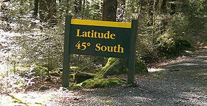
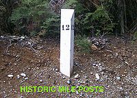
has kept the historic White Mile Posts that are a feature of the early days of the Milford Road Construction. The Department of Conservation has kept up the Latitude 45 South Marker but has abandoned the Avenue of the Disappearing Mountain to history as the avenue of trees beside the Road has become over grown.
Outside of the Milford Road, Mandeville is the site of the Croydon Aircraft Company
Croydon Aircraft Company
The Croydon Aircraft Company is an aircraft company in New Zealand. Its main activities include restoring vintage aircraft, providing scenic and aerial experience flights in vintage aircraft, and providing pilot training in vintage aircraft....
Link, and the local aerodrome
Mandeville Aerodrome
Mandeville Aerodrome is an airport at Mandeville, New Zealand. It is the home of the Croydon Aircraft Company which restores vintage aircraft, provides training scenic and aerial experience flights in vintage aircraft.-References:*NZAIP Volume 4 AD*...
is home to several rare vintage aircraft. Mossburn is the closest settlement to the Mount White Wind Farm which at full capacity can power almost all the entire Southland region. The Oreti
Oreti River
The Oreti River is one of the main rivers of Southland, New Zealand, and is 170 kilometres in length.The Oreti has its headwaters close to the Mavora Lakes between Lake Te Anau and Lake Wakatipu, and flows south across the Southland Plains to its outflow into Foveaux Strait at the southeastern end...
, Mataura
Mataura River
The Mataura River is in the Southland Region of the South Island of New Zealand. It is 190 kilometres in length.The river's headwaters are located in mountains to the south of Lake Wakatipu. From there it flows southeast towards Gore, where it turns southward...
and Waiau
Waiau River, Southland
Waiau River is the largest river in the Southland Region of New Zealand. It is the outflow of Lake Te Anau, flowing from it into Lake Manapouri 10 kilometres to the south, and from there flows south for 70 kilometres before reaching the Foveaux Strait eight kilometres south of Tuatapere...
Rivers that dominate the flatter regions of SH 94 between Gore and Te Anau are popular fishing spots for brown trout
Brown trout
The brown trout and the sea trout are fish of the same species....
. Care should be taken while fishing to prevent the spread of Didymosphenia geminata
Didymosphenia geminata
Didymosphenia geminata, commonly known as didymo or rock snot, is a species of diatom that grows in warm and shallow water. If it overgrows, it can form large mats on the bottom of lakes, rivers and streams. It is not considered a significant human health risk, but it can affect stream habitats and...
.
Driving State Highway 94
Tourists to Milford SoundMilford Sound
Milford Sound is a fjord in the south west of New Zealand's South Island, within Fiordland National Park, Piopiotahi Marine Reserve, and the Te Wahipounamu World Heritage site...
arrive mainly via coach
Coach (vehicle)
A coach is a large motor vehicle, a type of bus, used for conveying passengers on excursions and on longer distance express coach scheduled transport between cities - or even between countries...
over the length of SH 94 from Mossburn, a predominantly high mountain road which is prone to avalanche
Avalanche
An avalanche is a sudden rapid flow of snow down a slope, occurring when either natural triggers or human activity causes a critical escalating transition from the slow equilibrium evolution of the snow pack. Typically occurring in mountainous terrain, an avalanche can mix air and water with the...
s in winter. The road was only opened in 1953, after the Homer Tunnel
Homer Tunnel
The Homer Tunnel is a road tunnel in the Fiordland region of the South Island of New Zealand, opened in 1954. New Zealand State Highway 94 passes through the tunnel, linking Milford Sound to Te Anau and Queenstown, by piercing the Main Divide at the Homer Saddle...
was finished, after almost 20 years of intermittent work. The road is one of the more dangerous public roads in New Zealand, with injury crash rates around 65% higher than the rest of New Zealand's network, and a fatality crash rate of almost twice average (per vehicle kilometre travelled), making it the third most dangerous section of New Zealand's State Highway network (as of 2008). Stopping is prohibited on long stretches due to rock or snow avalanche dangers, and the road is often closed in winter, with the carrying of snow chains mandatory during snow conditions. Helicopters are used during winter to drop explosives onto snow buildup zones above the road in order to cause controlled avalanches. However this does not eliminate the danger that road traffic may be hit by an uncontrolled event, especially in the area of the Homer Tunnel portals.
There are no petrol stations on the length of the road from Te Anau to Milford Sound, meaning that vehicles need to take enough fuel for a return trip. All of this does not discourage up to 50 coaches and hundreds of private cars daily from making the 546 km trip from the nearest city Invercargill
Invercargill
Invercargill is the southernmost and westernmost city in New Zealand, and one of the southernmost cities in the world. It is the commercial centre of the Southland region. It lies in the heart of the wide expanse of the Southland Plains on the Oreti or New River some 18 km north of Bluff,...
, and the 572 km trip from popular tourist destination Queenstown
Queenstown, New Zealand
Queenstown is a resort town in Otago in the south-west of New Zealand's South Island. It is built around an inlet called Queenstown Bay on Lake Wakatipu, a long thin Z-shaped lake formed by glacial processes, and has spectacular views of nearby mountains....
. Almost 60% of tourists travel via coach, which is regarded as being safer than attempting the road on your own.
Weather conditions
Transit New Zealand
Transit New Zealand was, from 1989 to 2008, the New Zealand Crown entity responsible for operating and planning the New Zealand State Highway network...
check point has been built to make sure road users carry chains for safe passage to Milford Sound
Milford Sound
Milford Sound is a fjord in the south west of New Zealand's South Island, within Fiordland National Park, Piopiotahi Marine Reserve, and the Te Wahipounamu World Heritage site...
. Metal Gates are positioned across the Milford Road In the Hollyford and Cleddau Valleys when the road is closed at times of peak avalanche probability. Due to the nature of the Fiordland
Fiordland
Fiordland is a geographic region of New Zealand that is situated on the south-western corner of the South Island, comprising the western-most third of Southland. Most of Fiordland is dominated by the steep sides of the snow-capped Southern Alps, deep lakes and its ocean-flooded, steep western valleys...
Environment, the road can be closed at any time of year from landslips treefalls and washouts. Snow can fall on higher parts of the road any time of the year.
However the entire length of SH 94 is susceptible to snowfall during the winter months and care should be taken at any time of the year, especially on the hillier regions between Mossburn and Milford Sound. Flooding can also occur at anytime along the road especially around rivers.
Literature on the Milford Road
Building the Milford Road section of SH 94 has been a classic story of danger, hardship and Kiwi ingenuity in the Depression Yearsand has been the subject of several books: Harold Anderson’s 1975 Men of the Milford Road, a detailed account of the project from his perspective as a Public Works Department Paymaster; Wilson Campbell’s 2000 Novel When stars were brightly shining about a fictional murder in one of the works camps; John Hall-Jones’s, Milford Sound An Illustrated History of the Sound, the Track and the Road, which covers in detail the history of the road with ample historic photographs; and Amy McDonalds 2005 Below the Mountains, a young girl's diary of living on the Milford Road 1935 to 1936.
And there are mountain climbing books that cover this area in detail, such as Jack Ede’s 1988 “Mountain Men of Milford” and Anita Crozier’s 1950 Beyond the Southern Lakes.
Major junctions
| Territorial authority | Location | km | Destinations | Notes |
|---|---|---|---|---|
| Gore District Gore, New Zealand Gore is a town, surrounding borough, and district in the Southland region of the South Island of New Zealand.-Geography:The Gore District has a land area of 1,251.62 km² and a resident population of... |
Gore | 0 |  SH 1 north SH 1 north (Medway Street) Dunedin Dunedin Dunedin is the second-largest city in the South Island of New Zealand, and the principal city of the Otago Region. It is considered to be one of the four main urban centres of New Zealand for historic, cultural, and geographic reasons. Dunedin was the largest city by territorial land area until... |
SH 94 begins |
| SH 1 south (Main Street) Invercargill Invercargill Invercargill is the southernmost and westernmost city in New Zealand, and one of the southernmost cities in the world. It is the commercial centre of the Southland region. It lies in the heart of the wide expanse of the Southland Plains on the Oreti or New River some 18 km north of Bluff,... |
||||
| Southland District Southland District Southland District is a territorial authority in the South Island of New Zealand. Southland District covers the majority of the land area of Southland Region, although the region also covers Gore District, Invercargill City and adjacent territorial waters... |
Lumsden Lumsden, New Zealand Lumsden is a town in Southland, New Zealand. Lying in a gap in the surrounding hills, it is the location of a major junction halfway along the north-south road from Queenstown to Invercargill, where it is crossed by the east-west road from Gore to Te Anau. The town had a population of 453 as of the... |
61 |  SH 6 SH 6New Zealand State Highway 6 State Highway 6 is a major New Zealand State Highway. It extends from the northeastern corner of the South Island across the top of the island, then down the length of the island, initially along the West Coast and then across the Southern Alps through inland Otago and finally across the Southland... south (Diana Street) Invercargill Invercargill Invercargill is the southernmost and westernmost city in New Zealand, and one of the southernmost cities in the world. It is the commercial centre of the Southland region. It lies in the heart of the wide expanse of the Southland Plains on the Oreti or New River some 18 km north of Bluff,... |
SH 94/SH 6 concurrency begins |
| 64 | SH 6 New Zealand State Highway 6 State Highway 6 is a major New Zealand State Highway. It extends from the northeastern corner of the South Island across the top of the island, then down the length of the island, initially along the West Coast and then across the Southern Alps through inland Otago and finally across the Southland... north (Five Rivers Lumsden Highway) Queenstown Queenstown, New Zealand Queenstown is a resort town in Otago in the south-west of New Zealand's South Island. It is built around an inlet called Queenstown Bay on Lake Wakatipu, a long thin Z-shaped lake formed by glacial processes, and has spectacular views of nearby mountains.... |
SH 94/SH 6 concurrency ends | ||
| Oreti River Oreti River The Oreti River is one of the main rivers of Southland, New Zealand, and is 170 kilometres in length.The Oreti has its headwaters close to the Mavora Lakes between Lake Te Anau and Lake Wakatipu, and flows south across the Southland Plains to its outflow into Foveaux Strait at the southeastern end... |
||||
| Mossburn | 80 |  SH 97 SH 97 (Essex Street) Queenstown Queenstown, New Zealand Queenstown is a resort town in Otago in the south-west of New Zealand's South Island. It is built around an inlet called Queenstown Bay on Lake Wakatipu, a long thin Z-shaped lake formed by glacial processes, and has spectacular views of nearby mountains.... |
||
| The Key | 124 | (Hillside Manapouri Road) Manapouri Manapouri Manapouri is a small town in Southland / Fiordland, in the southwest corner of the South Island, in New Zealand. Located at the edge of the Fiordland National Park, on the eastern shore of Lake Manapouri, close to its outflow into the Waiau River, tourist boat services are based in the... |
||
| Te Anau Te Anau Te Anau is a town in the South Island of New Zealand. It is on the eastern shore of Lake Te Anau in Fiordland. Lake Te Anau is the largest lake in the South Island and second only within New Zealand to Lake Taupo. The 2001 census recorded the town's population as 1,857... |
138 |  SH 95/Southern Scenic Route SH 95/Southern Scenic RouteSouthern Scenic Route The Southern Scenic Route is a tourist highway in New Zealand linking Queenstown, Fiordland, Te Anau and the iconic Milford Road to Dunedin via, Riverton, Invercargill and The Catlins... (Manapouri Te Anau Highway) Lake Te Anau Lake Te Anau Lake Te Anau is in the southwestern corner of the South Island of New Zealand. Its name was originally Te Ana-au, Maori for 'The cave of swirling water'. The lake covers an area of 344 km², making it the second-largest lake by surface area in New Zealand and the largest in the South Island... , Manapouri Manapouri Manapouri is a small town in Southland / Fiordland, in the southwest corner of the South Island, in New Zealand. Located at the edge of the Fiordland National Park, on the eastern shore of Lake Manapouri, close to its outflow into the Waiau River, tourist boat services are based in the... |
||
| 238 | Homer Tunnel Homer Tunnel The Homer Tunnel is a road tunnel in the Fiordland region of the South Island of New Zealand, opened in 1954. New Zealand State Highway 94 passes through the tunnel, linking Milford Sound to Te Anau and Queenstown, by piercing the Main Divide at the Homer Saddle... 1270 m (4,166.7 ft) length |
|||
| Milford Sound Milford Sound Milford Sound is a fjord in the south west of New Zealand's South Island, within Fiordland National Park, Piopiotahi Marine Reserve, and the Te Wahipounamu World Heritage site... |
256 | SH 94 ends |
Further reading
- Ian Brodie. (2003) The Lord of the Rings Location Guidebook, Harper Collins, ISBN 1-86950-491-7, 126 pages
- John Hall Jones. (2000) Milford Sound, Illustrated History, Harper Collins, ISBN 0-908629-54-0, 144 pages
External links
- Milford Road at the Department of Conservation
- State Highway 94 on GoogleMaps
News